Could the Houston area see snow on Sunday? The answer is somewhat complicated

As a Jersey transplant, having a bonafide winter storm to forecast feels like a Super Bowl or something to me. So in this post, we’re going to go under the hood a bit on the ways it may or may not snow in the Houston area.

How it happens

First, let’s just tackle the big picture story. Why are we even talking about this? More often than not this time of year, we see storm systems pass by to our north and drag cold fronts through. And we get some rain or storms, and then it turns windy and cold but much drier behind the front. On Sunday and Monday, things happen a bit differently. First off, on Sunday morning, the air mass over Texas is quite chilly. This is a map of temperature anomalies 5,000 feet above our heads as forecast by the European model on Sunday morning.

A colder than normal air mass will be in place over Texas on Sunday and Monday, with an upper level storm passing across West Texas, the first ingredients necessary for a winter weather event here. (Pivotal Weather)

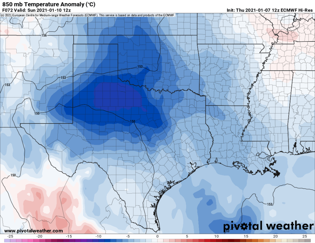
The air mass isn’t super cold, but it’s a few degrees colder than normal, colder still in West Texas with an upper level storm system passing by at 20,000 feet above their heads. While this certainly keeps things appetizing, the best word to describe the air mass over Texas is marginally cold. I’d like to see it colder to be more excited about snow chances. Alas, we’ll work with this.

What do we need next? Ideally, a coastal low pressure system at the surface. And we get just that on Sunday evening. By 6 PM or so, the European model shows the surface low just off Corpus Christi.

On Sunday evening, the European model shows a surface low pressure system off Corpus Christi. Rain has broken across the region, with pockets of sleet or snow mixed in along or north of Highway 105. (Pivotal Weather)

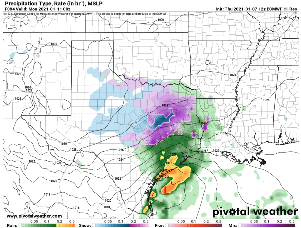
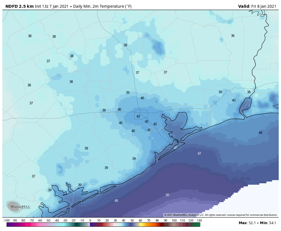
Keeping it to our south is critical because that will limit or inhibit warm air from being drawn into our area. So at this point in the game, widespread cold rain should be breaking out across the region. Temperatures will begin to fall toward the dew point as rain cools the air, and we may have temperatures down into the upper-30s to near 40 in Houston and south by evening, with mid to upper-30s north. It’s plausible that some sleet or snow could mix in with the rain at times, mainly along or north of Highway 105; think Lake Livingston, Conroe, Cleveland, Navasota.

Ultimately, how far north or south both the surface low and upper low (which is expected to be just east of the Caprock on Sunday evening) matter. If they shift farther south, colder air is possible and that rain/snow mix may start off farther south. The opposite is true if they’re farther north. Here’s an example. You see the European model above. The GFS model is very similar looking. The NAM model earlier this morning showed the surface low about 50 to 75 miles farther east at this same time, and it has the upper low south of Abilene, or about 175 miles farther south of where the Euro has it at this time. As a result, it would explicitly be showing snow as far south as Montgomery County at this point and pockets of a rain/snow mix closer to Houston. The most recent NAM model just came out, and it has the surface low about 25-50 miles farther north, which makes Houston warmer and keeps snow bottled up north of Highway 105. Which model is right? We have no idea right now. But this will be critical in determining how far south snow can get early on. We will watch this tonight and tomorrow into Saturday closely.

The other way to get snow

As we go into Sunday night, the storm will progress off to the east and northeast. For Houston and points south, again, mainly a cold rain with temps steady in the 30s or low-40s. North of Houston, it should be rain, periodically mixed with snow. Here’s the interesting thing about the chance of snow north of Houston, up along highway 105 or so though with this storm. I think it’s actually really legitimate. One of the hallmarks of this system showing up on the models this week is how “dynamic” it seems. There are several ways to get snow. Above, we talk about getting enough cold air via a favorable storm track. Now, let’s talk about dynamics. When you get enough vertical motion within a storm system, basically a lot of rising air, you tend to drop temperatures. We call this “dynamic cooling.” In winter storms like this, another way to get snow is for it to essentially rain so hard that the air cools enough for the rain to flip over to snow. I think we are close to having a case be made with this storm that we could see enough dynamic cooling occur that, in spots, heavy rain could suddenly flip to heavy snow at the height of the storm Sunday evening. Thundersnow can’t be ruled out either.

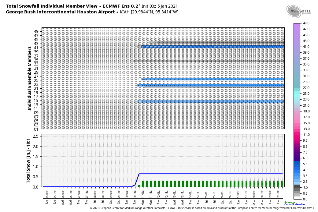
Let’s get even more technical. If we look at the latest NAM model from this afternoon, we can see how this might occur. The image below is what we call a time-height cross-section. It’s basically taking a specific location, in this case Conroe, and looking at how vertical velocity (VV, or rising air) and the dendritic growth zone (DGZ, or where air temperatures cool to roughly -10 to -20°C, good for snowflake production) change over time.

A time-height cross-section from the NAM model at Conroe that shows we are not far away from being in a favorable environment for some snow to develop dynamically. Click to enlarge. (BUFKIT/NOAA)

You can click the image to enlarge it. In that image above, one thing stands out to me. We have a lot of vertical velocity with this storm, and the strongest VVs come close to punching the heart of the dendritic growth zone at times. In English? That creates a very sloppy setup where, yes, we may see rain most of the time, but if it rains hard enough, there will be pockets anywhere (mainly north of I-10 though) that could change from rain to accumulating snow or sleet and back to rain at times.

This means that it will be difficult to near-impossible to give you a snowfall forecast right now, as those sorts of processes are very small scale. I come from the Northeast, and they’re difficult to forecast this far out up there; they’re next to impossible to forecast this far out in the South.

As the storm pulls away early on Monday morning, enough colder air may drift in to have the rain end as some light snow or flurries/drizzle across parts of the area, again mainly north of I-10. No accumulation would be expected from that. Monday will likely be a gray, cold day.

So let’s summarize what we’ve got quickly.

  • Snow, and accumulating snow at that is becoming more likely across the northern stretches of Southeast Texas, particularly along and north of Highway 105.
  • Accumulating snow can’t be ruled out anywhere north of I-10 just yet, but it’s more likely that some places maybe flip back and forth from rain to snow/sleet to rain with little to no accumulation. 
  • Ice is not likely with this storm, though well north of Houston, some roads could be slick at times (think Huntsville or Lake Livingston areas). 
  • There is still sizable uncertainty on specifics regarding the details of this storm and significant forecast changes may occur between now and Sunday.
  • Locally heavy rain is possible south of Houston, along with some thunder.
  • It will likely be a bit windy as well, and there is the potential for some coastal flooding along the Gulf, with rough seas and strong rip currents.

More for you tomorrow morning!

After three sunny days rain will return to Houston. And up north, some snow too

After Wednesday evening’s line of storms, the Houston region will see several days of placid weather before another front arrives later on Sunday. This will bring with it a stronger shot of colder air and, for areas just north of Houston, the potential for snow. Cold weather will prevail throughout the period.

Thursday

Temperatures have dropped into the 40s across much of the area this morning, and in concert with northwesterly winds it feels brisk outside. Winds should slacken this afternoon, but even with mostly sunny skies our high temperatures are unlikely to climb above the mid- to upper-50s. Lows tonight will drop down to around 40 in the city of Houston with partly cloudy skies and light northerly winds.

Friday will bring another chilly morning into Houston. (Weather Bell)

Friday

This will be another mostly sunny and cold day, as northerly winds continue to bring dry air into the region. Expect highs generally in the mid-50s, and with clear skies overnight temperatures may be a few degrees cooler on Friday night than Thursday night.

Saturday

This will be our third chilly, sunny day in a row with highs again in the 50s. As winds shift to come from the east clouds may begin to build during the afternoon or overnight hours, but lows should still get down to around 40 in Houston overnight.

Sunday and Sunday night

An approaching front will combine with surface low pressure over the northwestern Gulf of Mexico to produce healthy rain chances on Sunday and Sunday night. We can be pretty confident this will be a cold and gray day, during which highs will struggle to climb above 50 degrees. Rain chances will increase as the day goes on. For now, it appears as though the greater rain accumulations will remain to the south of Houston, where totals could be on the order of 1-2 inches. However, north of a line from Wharton to Alvin to League City will probably see less, perhaps 0.5 to 1 inch of rain with this front. We’ll have to iron out those details in future forecasts.

It’s going to snow in Texas this weekend. The question is, how close will it get to Houston? Here’s the European model’s guess this morning. (Weather Bell)

We think things will be warm enough in Houston to keep this precipitation rain throughout the day and overnight hours, but there will be a dividing line—perhaps somewhere in Montgomery County?—where this precipitation turns into snow or sleet on Sunday evening. Matt will provide an update on the region’s snow chances with a post later today.

Next week

Our region will be cold and sunny next week in the wake of the front, with highs generally in the 50s and lows in the 30s. The urban core of Houston may remain above freezing, but there will almost certainly be freezing temperatures in the vicinity of the city, if not the entire metro area itself.

Virtual Houston Marathon

Due to the pandemic, the Houston Marathon is a virtual event this year. So instead of being run as a single event on January 17, participants can run their half and full marathons on any day between Friday, January 8 and Sunday, January 17. If you have some flexibility in your schedule, you will have options for weather. (My ideal conditions are temperatures in the 40s, clouds, and light winds, but we’re all different!) Both this Saturday and Sunday look chilly, and if you complete your run before noon on Sunday you should miss the rain. The absolute coldest temperatures in the week ahead should come on Tuesday morning, January 12, when I expect a freeze for most of Houston.

Then we’ll see a slight warming trend through Friday, with mostly sunny skies throughout. Next weekend looks a bit warmer, but basically every morning during the virtual marathon period is likely to see lows in the 30s or 40s for Houston. If you prefer warmer weather, then the coming Friday, Saturday, or Sunday afternoons—January 15-17—may be your best bet as highs get into the upper 60s, perhaps. Rain chances seem fairly low throughout the running period, aside from the Sunday, January 10th mess described in the forecast above.

Storms will cross Houston later today, chilly weather to stay awhile

Houston will see a front bull through the area this afternoon and evening, and this could briefly bring strong showers and thunderstorms into the region. The front will move from west to east, clearing quickly. We’ll then see calm and cool weather until another front arrives Sunday. This second front will bring near freezing conditions to the metro area and a slight chance of snow north and west of the city.

Wednesday

Lows across much of Houston have only fallen to around 60 degrees, with a southeasterly wind providing a moderating flow of air. Skies are cloudy, and will remain so throughout the day due to elevated moisture levels in the atmosphere. Highs will get into the low 70s for most. We may see some scattered showers during the daytime hours, but the big event—the front—will come later. In terms of timing, I expect it to reach a line from Katy to Conroe between 3 and 6 pm today, central Houston an hour later, and to be off the coast between 6 and 9 pm tonight. The main threats are brief, heavy rainfall, and strong wind gusts. There is a very slight chance of an isolated tornado. Total rainfall amounts will likely average 1 to 1.5 inches north of interstate 10, and 0.5 to 1 inch closer to the coast.

NOAA severe weather outlook for Wednesday.

Thursday and Friday

Thursday morning will see gusty winds, perhaps as high as 30 mph, as colder and drier air moves into the region. However, winds should subside somewhat during the afternoon hours. Expect mostly sunny skies and temperatures in the mid- to upper-50s on Thursday and Friday, with lows dropping to around 40 degrees in the city—colder north, and warmer near the coast.

Saturday

This should be another winter-like day for Houston, with highs in the 50s and a chilly night down around 40, with mostly sunny skies.

The next 10 days look rather chilly for Houston. (Weather Bell)

Sunday and beyond

The forecast for our second front this week remains uncertain. However, at this point we can probably pencil in cold, gray, and wet conditions for the second half of the weekend. This front could bring an additional 0.5 to 1 inch of rain to the Houston area on Sunday, but that is not set in stone. Nor can we entirely rule out the possibility of snow or sleet. However, right now it appears the track of air cold enough to allow for wintry precipitation will pass just north of Houston. Bottom line, we’re going to have to watch and see how the forecast evolves.

Anyway, Sunday will be chilly, with highs perhaps in the 50s, depending on the timing of the front. After it passes, much of next week looks cold and sunny, with highs in the 50s, and lows in the 30s and 40s.

Houston may see storms Wednesday, and much colder weather this weekend

Good morning. After several days of calm weather and sunshine, Houston’s forecast will soon turn a bit more dynamic for the rest of the week. We could see some storms with a frontal passage on Wednesday, and then more inclement weather with a front coming this weekend. With the latter front we think there is even a slight chance of wintry precipitation, including possibly snow, which we’ll discuss below.

Tuesday

This morning we have some fog issues for coastal areas, but this should clear up pretty quickly. Highs will reach about 70 degrees later today under mostly sunny skies. As winds come from the southeast later today, tonight will be the warmest one of the year so far, and probably for at least the next week. Lows probably will only drop into the mid-50s for much of the region.

Lows on Wednesday morning will be the warmest of the week. (Weather Bell)

Wednesday

We still have some questions about the timing and speed of the front, but the most likely time for its passage is around sunset in Houston, and a little bit later along the coast. Daytime temperatures therefore should reach about 70 degrees, with mostly cloudy skies and scattered showers. A line of storms is expected to move along with the front, and how fast the front moves will determine rainfall amounts. We probably will see accumulations of about 1 inch or so north of Interstate 10, and approximately 0.5 to 1 inch closer to the coast. Rains will end quickly with the front’s passage, as cooler and drier air moves in during the evening and overnight hours.

Thursday and Friday

The end of the week will be sunny and cool, with highs of around 60 degrees and lows near 40 in the city of Houston—cooler inland and warmer along the coast.

Saturday

The first half of the weekend should be similarly pleasant, with highs of around 60 degrees and partly to mostly sunny skies.

Sunday and beyond

The next front looks set to arrive on Sunday. The details are sketchy, but there is at least the potential for some wintry precipitation. As the front pushes into Houston there will be plenty of moisture along with a southerly storm track, and enough lift to generate precipitation. (Rain accumulations with the front probably will be on the order of 0.5 to 1 inch). The question is whether there will be enough really cold air in the atmosphere for freezing conditions almost all the way to the surface. That’s more likely the further north along Interstates 45 and 69 one goes. Right now I’d estimate that snow chances are decent for places like Huntsville and Livingston. However, we’re probably still at 20 percent, or less, for the city of Houston itself. But it will be something to watch.

There is a little bit of support for snow on Sunday in Houston in the European model ensemble forecast. (Weather Bell)

Temperatures should be cold in the wake of Sunday’s front, with daytime highs generally in the 50s, and nighttime lows in the 30s and 40s to start next week.