We’ve upgraded our hardware and software to meet your needs

Space City Weather is growing—our traffic exceeded 12.5 million page views in 2020—and this morning we took the steps needed to ensure the back-end of the site can keep up with demand.

Our previous server, nicknamed Garak, was two years old. So we moved to new, faster hardware that can accommodate our growing demands. Specifically, we’ve upgraded to a new dedicated server running Ubuntu 20.04, which lets us take advantage of the latest improvements to all the software that runs Space City Weather (including TLS 1.3 support, which is a big deal).

The new server is nicknamed Dukat. The nerds among you will get the reference, I am sure. If you want more details about the site’s technical back end, Lee Hutchinson wrote an excellent piece in August about how he keeps things running for us.

We also changed Word Press themes, which has led to a very modest site redesign. Our original theme, “Jennifer,” was nearly a decade old. The new theme is much more customizable and should allow for a better reading experience with a wider web width. Please bear with us while we shake a few gremlins out of the site redesign over the next few days. In the end, it should look better on both mobile and desktop.

Expect more announcements in the coming weeks in terms of improving our offerings to meet your needs. This was all made possible thanks to Reliant and the generous support of our readers.

Another cold front this weekend keeps Houston temperate

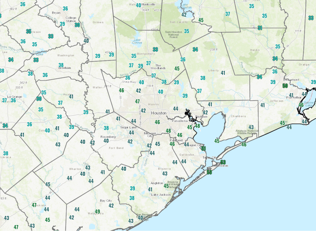
Good morning, and it’s a cool one across the region. Temperatures this morning ranged from the 30s north of Houston to the lower and middle 40s in the city to the low to mid-50s at the coast.

Friday morning temperatures range from the 30s north of Houston to the lower and mid-50s at the coast. (NOAA)

That cool weather will be departing later today and tonight — temporarily.

Today

We are already seeing broad onshore flow begin to resume at the coast, with low clouds moving into Galveston and southeast Harris Counties and humidity inching upward. That will be the trend today. Expect sunshine with some periods of clouds at times, perhaps becoming a bit more noticeable later today. We should manage the low-60s or a touch warmer in spots for highs.

Tonight & Saturday

Clouds become more established tonight, and we could see some light rain or drizzle in spots, in addition to some patchy fog late tonight at the coast. Temperatures won’t go very far tonight, and in fact they may rise out of the mid-50s toward daybreak across the region. We’ll end up in the upper-60s to low-70s tomorrow despite a good bit of cloud cover.

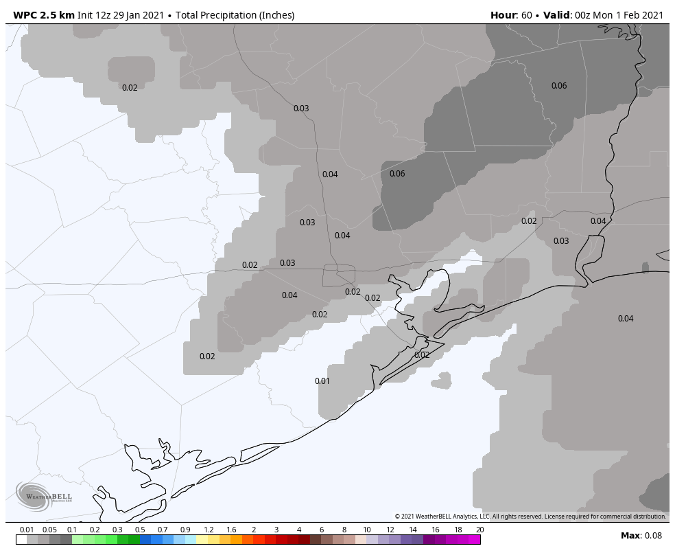
Our next cold front will approach the region late tomorrow. Expect showers to accompany it, but we are unlikely to see any sort of significant rain from this. It’s also entirely possible that your neighborhood sees no rain at all.

You may get rain later Saturday and Saturday night, but you won’t get much. (NOAA via Weather Bell)

The current official forecast calls for no one seeing more than a tenth of an inch of rain. We think that’s reasonable, as this front will mostly just serve to usher in cooler, drier air and gusty winds for Sunday. Speaking of…

Sunday

On Sunday, you’ll definitely know that a cold front has moved through. It will be breezy to windy and cooler. Sunday’s temperatures will warm from the low-50s in the morning to the mid-60s, give or take in the afternoon. Winds will be blustery out of the north at 15 to 20 mph inland, gusting to perhaps 25 mph or so over the water. The better news is that it looks bright and sunny for Sunday!

Monday & Tuesday

More sunshine is expected on Monday. It will be a cool morning, with lows in the 30s and 40s, similar to today and yesterday. Afternoon highs will get up into the 50s or lower 60s. Tuesday looks very similar to Monday with sunshine and temperatures about the same in the morning but perhaps a few degrees warmer in the afternoon.

Later next week

We should see a warming trend and return to onshore flow on Wednesday and Thursday. Clouds return, as do some fog and rain chances. But our next cold front is slated to arrive Friday, which should bring some widespread rain and then cooler, drier weather for the weekend. More on this one Monday!

Houston to continue riding that winter roller coaster

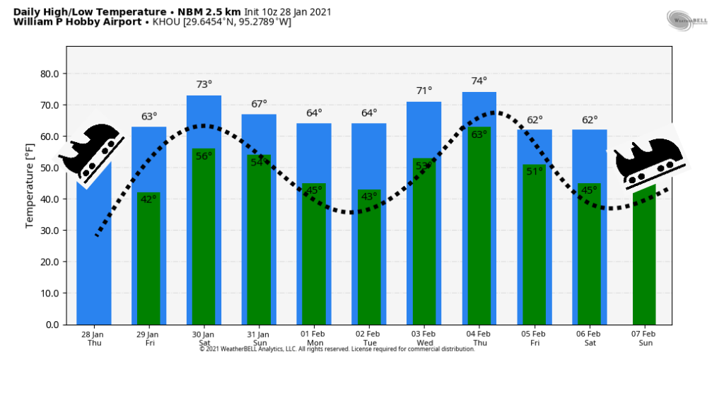
Yesterday, I talked about the merry-go-round nature of Houston’s weather during the winter—the ebb and flow of cold fronts, then warm fronts, and then cold fronts—and that pattern will very much remain with us for the foreseeable future. So strap in to ride that winter roller coaster, y’all!

Thursday

Today will definitely be on the cooler side. Lows have generally fallen into the low 40s across most of the metro area, and we’ll be slow to warm up with a persistent northeasterly flow. High temperatures for some locations may not even reach 60 degrees, despite partly to mostly sunny skies. Winds will shift to come from the east overnight, and this will allow for some clouds to form. Lows on Thursday night should be similar to those of Wednesday night.

Friday

As high pressure moves away, winds will start to blow from offshore. However, given the dry airmass in place, Friday should still be a sunny, relatively cool affair with highs in the mid-60s. The more moist flow from offshore will really make its presence felt by Friday night, with mostly cloudy skies, and lows only dropping into the upper 50s.

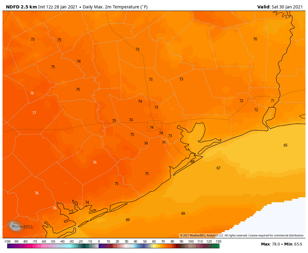
Saturday will be a warm day, for January. (Weather Bell)

Saturday

After the warmer night, Saturday could start out with some fog, especially near the coast. This will be a warmer day, with highs nudging up into the mid-70s, despite mostly cloudy skies. Later in the day, or during the evening hours, very light rain may fall across parts of the city, but this should be more of a misting than an accumulating rainfall for most. Saturday night’s low temperatures will depend on the timing of the front, which is likely to move through between midnight Saturday, and sunrise on Sunday, give or take. A broken line of showers may accompany the front’s passage.

Sunday and Monday

This should be a sunny, breezy day, with highs in the upper 60s. Lows will drop into the 40s, and Monday should be clear and cool as well, with afternoon temperatures in the low- to mid-60s. After that temperatures will be back on the upswing!

Houston’s magical roller coaster ride. (Weather Bell)

Next week

It sure looks like we’ll see a warm-up during the second half of next week, before yet another cold front. This one may, or may not, be pretty strong. (How’s that for helpful!) For now I’d bet on next weekend being fairly cool—but precisely how cold is impossible to say.

Temperatures up, then down—it’s the Houston weather merry-go-round

Good morning! A second, stronger cold front moved into Houston overnight and this will set the stage for more winter-like conditions through the end of the work week. Then temperatures will begin to rise again this weekend, before the arrival of yet another front. So it goes in Houston, during the winter.

Wednesday

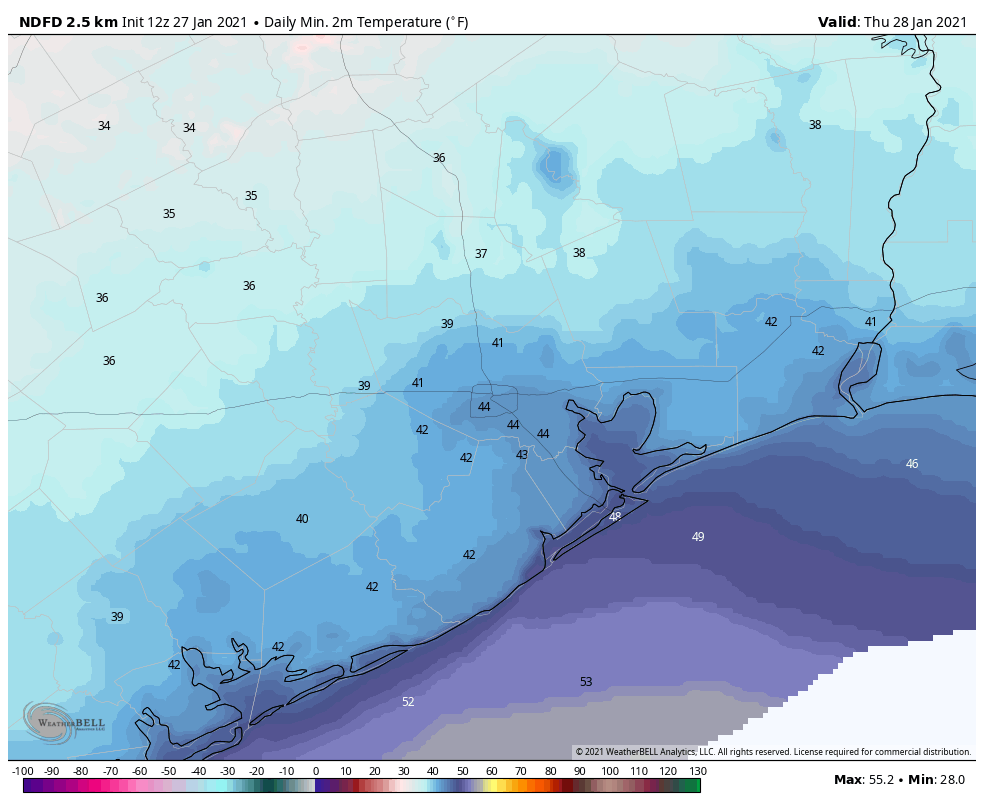
Today will be breezy as the cooler, dry air bulls into Houston behind the front. Expect gusts as high as 20 mph at times, perhaps even a bit stronger right along the coast. Skies should gradually clear out, with highs working themselves into the mid-60s or so for most areas. Winds should gradually subside this evening, as lows drop into the low- to mid-40s in the city of Houston—colder inland, and warmer along the coast.

Forecast low temperatures for Houston on Thursday morning. (Weather Bell)

Thursday

This should be the coldest day of the week. Combined with the cold air, a few clouds may help to limit high temperatures to about 60 degrees. It should be another chilly night, with lows dropping into the mid-40s in Houston.

Friday

After dominating our weather for a few days, high pressure should begin to slide off to the east, and this will eventually induce a more southerly flow. However, I think Friday will still see mostly sunny skies, and with its cold start highs probably will only get into the mid-60s. Lows Friday night will be warmer, perhaps dropping into the mid- to upper-50s.

When high pressure dominates during the winter, Houston typically has clear and calm conditions. (National Weather Service)

Saturday

The first half of the weekend will be warmer, with highs somewhere in the 70s, and mostly cloudy skies. As atmospheric moisture levels creep up, rain chances will rise during the afternoon and evening hours, perhaps to 40 or 50 percent. However, any rain that falls on Saturday evening or during the overnight hours will very probably be light, with overall accumulations for most areas likely around one-tenth of an inch. A cold front should push through during the overnight hours, although whether that happens around midnight, or later at sunrise on Sunday, is anyone’s guess right now.

Sunday

This should be a pleasant, breezy, sunny day with highs of around 70 degrees in the wake of the front. Lows on Sunday night should drop into the 40s for most.

Next week

And so it goes during winter. High pressure should dominate through Tuesday, or so, with its attendant sunny skies. Then we’ll be back into a warmer, more humid pattern until the next front arrives. It seems possible that this one—arriving around February 5 or 6—may have more oomph than the last few. Temperatures may flirt with freezing levels again in Houston, although that’s just speculation for now.