Conditions are very warm and muggy this morning, with lows across Houston in the 70s. This will change in a few hours, however, as a blustery cold front moves through and makes for a very windy afternoon and overnight period. This front will knock lows into the 40s across much of the area—probably the last time that will happen for some locations this spring.
Wednesday
The aforementioned front should reach the College Station area around sunrise, central Houston around Noon, and push off the coast by mid-afternoon. A broken line of light showers may strengthen as it nears the coast, and finds more moisture. Thunderstorms will be possible immediately along the coast.
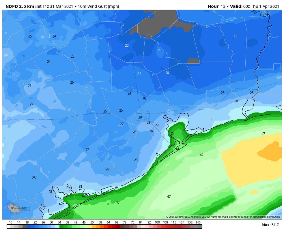
Forecast for wind gusts shortly before sunset on Wednesday. (Weather Bell)
Temperatures will drop into the upper 50s to 60 degrees after the front’s passage, and winds will likely gust above 30 mph. Those winds will taper off a bit after sunset for areas north of Interstate 10, but blow along the coast for most of the night. Lows will drop into the 40s, even in Galveston, after midnight.
Thursday
Winds will drop back some on Thursday, although northerly gusts in the low 20s will be possible. Highs will rise into the mid- to upper-60s along with sunny skies. Overnight lows will drop again into the 40s, with some areas in Montgomery County possibly seeing the upper 30s.
Friday
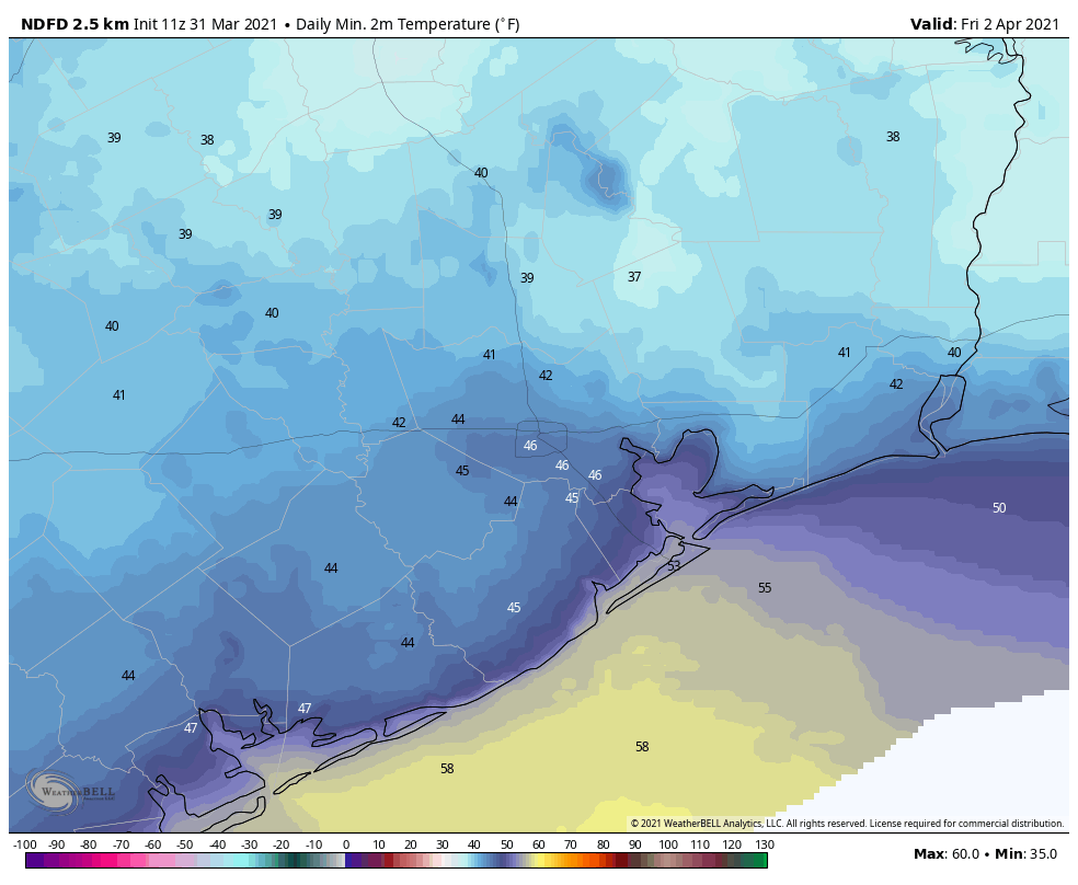
This will be another sunny day, with highs likely slotting somewhere into the upper 60s. Winds will shift to come from offshore later in the day, and this should moderate overnight temperatures a bit.
Forecast low temperatures for Friday morning. (Weather Bell)
Saturday
Clouds return, and even with southerly winds this should help to limit highs to around 70 degrees.
Easter Sunday and beyond
Sunrise temperatures will start in the 50s for most, with the coast a little bit warmer. Sunday should bring a little more sunshine, although the afternoon will probably still see partly to mostly cloudy skies. Highs will reach the mid-70s. We also can’t entirely rule out a few scattered, light showers during the afternoon and early evening hours, but most of us will probably remain dry.
As high pressure builds over the region, temperatures will begin climbing into the mid-80s next week, with at least partly cloudy skies. We’ll start to get familiar with our old friend humidity again.
Good morning. Houston’s forecast remains on track, with warm, humid weather before a strong front moves into the region on Wednesday. This will clear out our skies, and cool down our temperatures for most of the rest of the week. Enjoy this spell of cooler weather, as April is right around the corner.
Tuesday
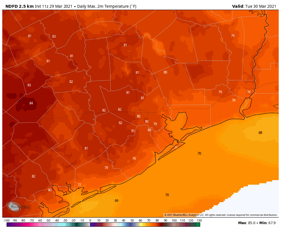
It’s a misty, warm morning for much of the region, with temperatures in the mid- to upper-60s. Humidity is near 100 percent. Some of these clouds will depart later today, and a little sunshine may peak through as highs reach into the low 80s. We could see a few very scattered, very light showers later today and tonight as temperatures remain in the low 70s near the coast, and maybe fall into the upper 60s for inland areas. It will be a warm night, a promise of things to come as the region edges closer to summer.
Tuesday will be quite warm for the region. (Weather Bell)
Wednesday
But it’s not summer yet, as a front on Wednesday will attest! In terms of timing, the front should reach far western and northern parts of the Houston metro area around sunrise, push into the central city by around Noon, and move off the coast during the early afternoon hours. A line of light showers will probably accompany the front, but accumulations should measure only about a tenth of an inch for most. Temperatures will drop about 15 degrees with the front’s passage, into the 50s. Winds will be quite strong out of the north, with some areas seeing 30 mph or greater gusts.
Thursday and Friday
These will be colder and sunnier days. Look for highs in the 60s (perhaps low 60s on Thursday) and lows generally in the 40s for most of the region, and much drier air. We won’t be seeing many more days in the 60s until next fall at the earliest, I suspect.
Low temperatures Thursday morning will be quite chilly. (Weather Bell)
Saturday and Sunday
By Friday night the onshore flow should return, and this will likely push high temperatures to around 70 degrees by Saturday, and the mid-70s on Easter Sunday. Skies will be partly sunny. The real question is whether we see any rain as atmospheric moisture levels creep back up. For now I think an atmospheric inversion will prevent enough rising air to produce showers, which in any case would be light and scattered were they to develop on Saturday evening or Sunday. Bottom line: Your outdoor Easter plans are probably safe.
Next week
The trend for next week will be one of warming, as highs rise into the 80s, and perhaps even the mid-80s. After Wednesday’s front we’re not seeing any strong indications of another cold front next week. That probably will change at some point, but the warming trend seems clear.
Good morning. Temperatures have generally dropped into the 40s and lower 50s this morning across much of the region, but this flirtation with cooler weather will soon end as winds return from offshore. A stronger front arrives Wednesday, which will bring sunny days and chilly nights heading into Easter weekend. The holiday itself looks pleasant, although we can’t have complete confidence in the forecast this far out.
Monday
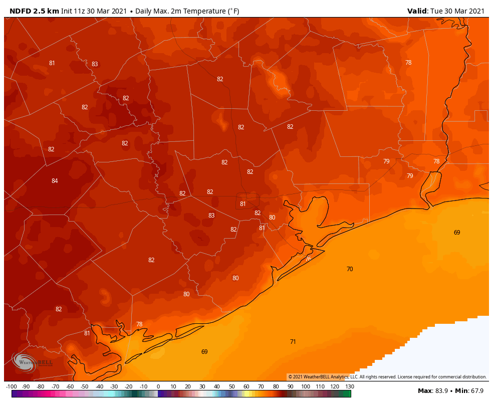
Temperatures will rise into the low- to mid-70s today, and really, it’s going to be a rather nice spring day. Skies will be mostly sunny, and winds light, shifting from the north to come from offshore later today. This will be most noticeable in Brazoria and Galveston counties, where some clouds may develop after noon, with a slight chance of showers as well south of Houston. The change in winds will also make for a warmer night, with lows only falling to around 60 degrees in Houston.
High temperatures on Tuesday will be the warmest of the week. (Weather Bell)
Tuesday
Southerly winds will become more noticeable on Tuesday, with mostly cloudy skies. We may see some gusts in the low 20s. The warmer, more humid flow will push temperatures to about 80 degrees, and may produce some very light, scattered showers across the region. Tuesday night’s lows will only drop into the upper 60s.
Wednesday
After a warm night, a cold front will swoop into Houston on Wednesday morning. We still have some questions about timing, but as a best guess the front probably reaches Katy and The Woodlands around sunrise, pushes into the central part of Houston by mid-morning, and off the coast by noon. It looks like a line of light showers will accompany the front, perhaps bringing a tenth of an inch of rain, or so, to most. Temperatures will drop into the 50s behind the front, with blustery northerly winds. Wednesday night’s lows should fall into the 40s for most areas but coastal counties.
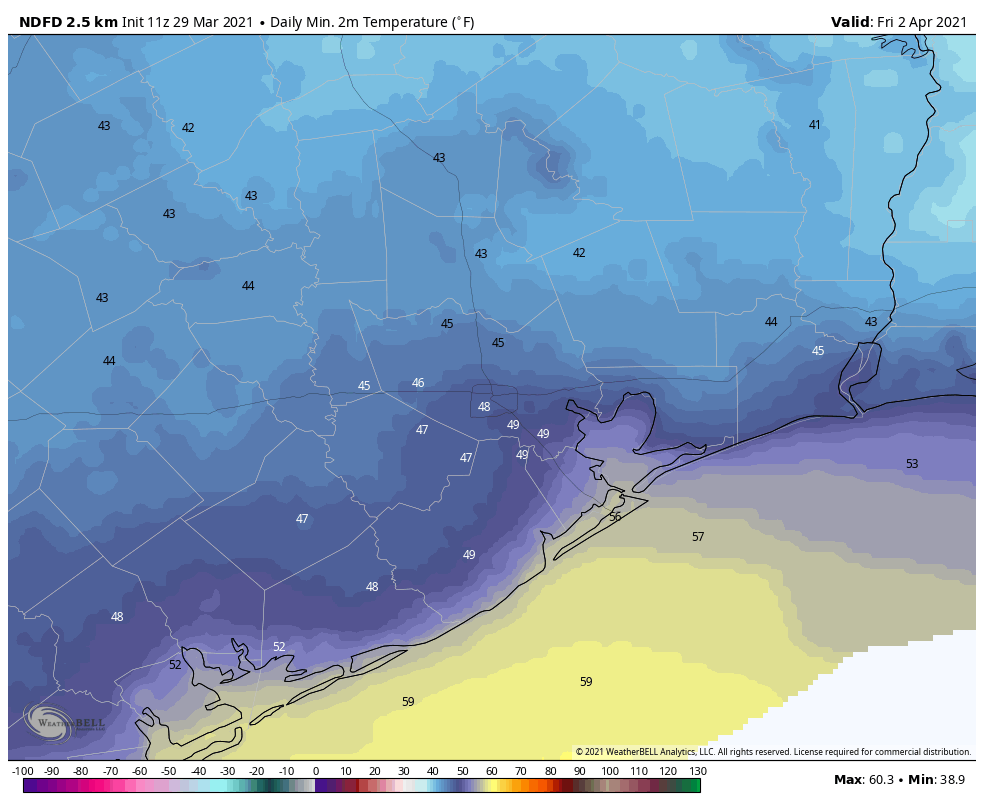
Thursday and Friday
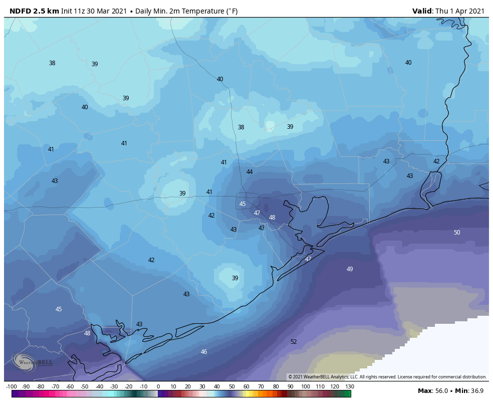
We’ll see a sunny and chilly end of the week, with highs on Thursday and Friday in the 60s, and overnight lows Thursday night in the 40s, and low 50s on Friday night. We do not anticipate any freezing temperatures, even for well inland areas. Enjoy!
Thursday night’s temperatures will probably be the coldest of the week. (Weather Bell)
Easter weekend
Our confidence in the weekend forecast is not particularly high yet. I think we’ll see a mix of sunshine and clouds as the onshore flow returns. Saturday probably will see highs in the 60s, and Sunday will rise to around 70 degrees. While we can rule out any rain chances, for now I think the holiday weekend will probably remain dry.
It’s another pleasantly cool morning in the Houston area, with morning lows in the 40s and 50s today. This weekend will present a mixed bag of weather, with a lovely start to Friday, followed by warmer, more humid, and drearier conditions heading into Saturday. A cold front Sunday will bring us a chance of rain and thunderstorms. We are growing more confident that a very robust cold front will slice through the area later next week, ushering some pretty cool temperatures for early April just ahead of Easter weekend.
Today
Look for outstanding weather today. Sunshine and blue skies to start, and we’ll watch for clouds to build in later today. We should see high temperatures approaching or exceeding 80 degrees this afternoon in many locations.
Saturday
Clouds will thicken up and begin to lower tonight as onshore flow ramps up behind a warm front. This should mean fog and drizzle overnight. So expect Saturday to start off a bit dreary in much of the area. We could see partial clearing Saturday afternoon, and as we do, a few showers may develop mainly north of I-10 in the afternoon. We will see highs likely in the 80s after morning lows in the 60s.
Sunday
A cold front will drop into the northern part of the area on Saturday night. Showers and a few thunderstorms may begin to develop out ahead of the front across the Houston area overnight and early Sunday. Weather models are still split on exactly how far offshore how fast this front gets on Sunday. Some hang the front back over Houston, while others push it offshore. It’s easy to see the model differences just by looking at the rain forecast on Sunday in our area from each of them
Clearly the Euro & Canadian hold back the front, generating more rain, while the NAM & GFS are much more progressive, pushing most rain well offshore.
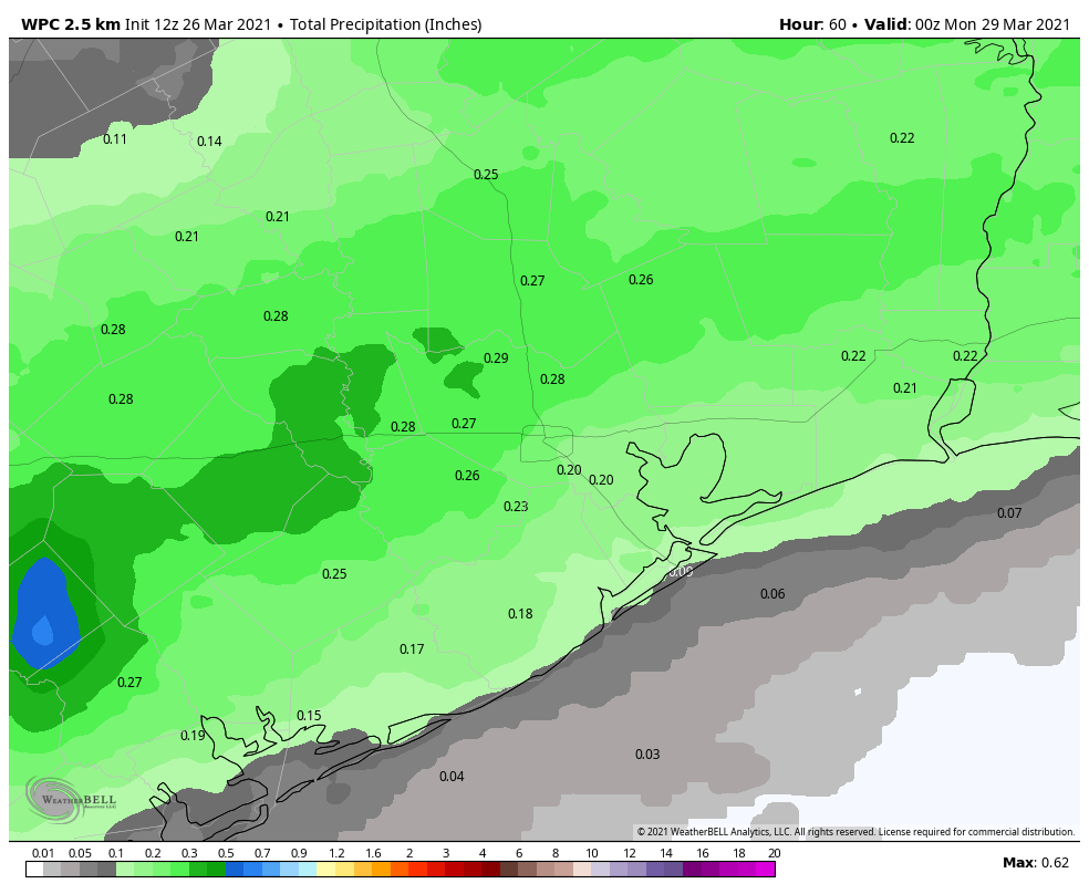
The NWS rainfall forecast sort of splits the difference with about a quarter-inch through Sunday evening. Some places will see little to no rain aside from Saturday’s drizzle. Other areas could see some heavier downpours on Sunday. (Weather Bell)
While there’s clearly a bit of uncertainty still, I would probably argue for splitting the difference right now: The best chance of showers should be south and east of Houston, while areas north and west see little to no rain on Sunday. I would say about a quarter-inch of rain on average. Higher amounts can’t be ruled out if the front stalls onshore, but at the same time, the rain will be sporadic enough that some places may see little to no rain at all.
Temperatures will also be tricky to pin down. Everyone should see highs somewhere in the 70s on Sunday. Morning lows, however, may range from the upper 50s northwest of Houston to upper 60s in the city and toward the coast.
Early Next Week
By Monday morning, even the Euro and Canadian models have pushed the front offshore, and the area should see a fairly nice day with highs in the 70s after morning lows in the 50s. Onshore flow kicks back into gear Tuesday with more clouds, a slight chance of drizzle or light rain, and high temperatures ramping back up into the 80s probably.
Big pre-Easter cold front
Weather models seem to be in pretty good agreement overall regarding later next week. Onshore flow really begins to ramp Tuesday night into Wednesday. A cold front will approach later Wednesday or early Thursday. This one has a little more muscle behind it than most recent fronts, so expect to see a pretty substantial drop in temperatures once it clears.
What we are confident in: A cold front with some showers, followed by much cooler, drier air sometime Wednesday or Thursday lingering into the weekend.
What we are not confident in: The exact timing of the front, how much rain, exactly how cool the air will be behind the front, the odds of a light freeze in northwestern parts of the area, and whether or not we can keep the pleasant weather going all the way to Easter Sunday.
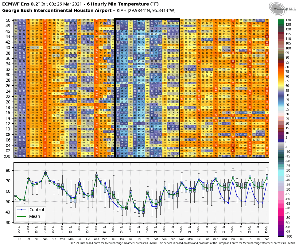
Given the model data right now, once it clears our area, we’ll likely see something on the order of highs in the upper-60s with lows in the 40s for late next week. There are a number of European ensemble members even pushing lows into the 30s for Houston next weekend! It’s too soon to talk about a late season light freeze in northwest parts of the area, but it’s worth monitoring if you have things planted. Each model run this week has progressed a couple degrees colder with the air mass late next week, so our confidence in this has nudged up a little also.
A chart of forecast lows from the 51 different European ensemble members shows strong agreement in a much cooler air mass late next week with lows likely in the 40s, possibly even a little colder.
Can the nice weather keep going into Easter Sunday? Maybe. I think the smart money is on the air mass starting to warm up a bit by then with some added cloud cover, but at this point we don’t see a significant risk of rain at least. Eric will have the latest on this for you on Monday.