Unsettled start to Houston’s Memorial Day weekend will likely evolve into a pretty nice one

Happy Friday! Before we dive into the forecast, I just want to give a shoutout to Tim Zacharias at Cougar USA. I sat down with him a few weeks back on their Building Value podcast, and I got to talk a bit about Space City Weather, flooding, the freeze, and hurricane season. You can check it out on YouTube, iTunes, or Spotify. If you watch on YouTube, you get the added bonus of seeing Mullet Matt’s pandemic hair (which is now gone, thankfully!).

On to the forecast, as we have some things to discuss.

Today

Things are quiet around Houston this morning. Lingering storms from last night are moving southeast up north of us, across Walker, Trinity, and Polk Counties. These storms will weaken, but the boundary they’re leaving behind is likely to become the focal point for thunderstorm development this afternoon closer to Houston.
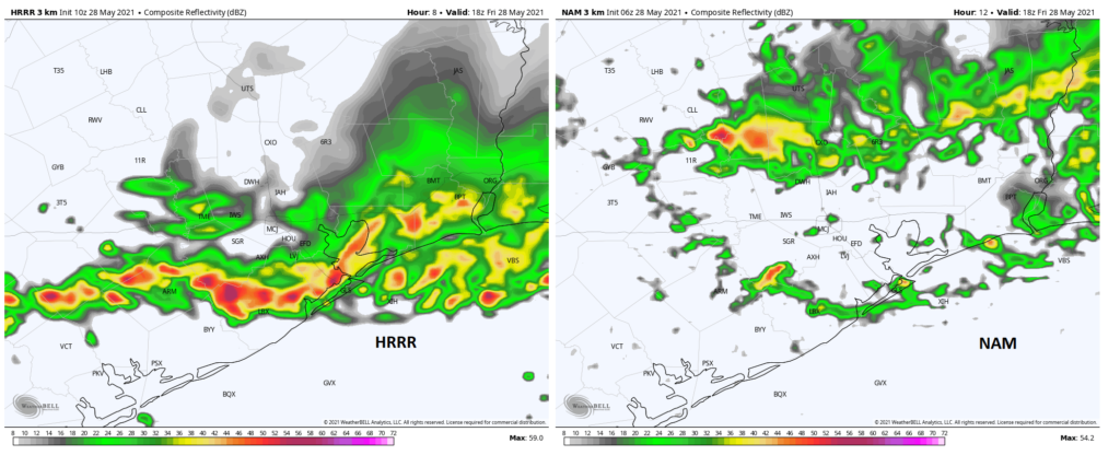
Two models, two different outcomes forecast for 1 PM CT, with the HRRR aggressively developing storms this afternoon, and the NAM being a bit less excited. Both models do suggest storms will develop in spots though. (WeatherBell)

Storms today could become fairly strong and locally severe, so don’t be shocked if you see a couple warnings in a few spots get triggered this afternoon, particularly for hail or strong winds. Some models are more aggressive than others with storm development this afternoon, so it’s certainly possible that some neighborhoods don’t see much of anything today, but a majority of the ingredients we need for storm development today are in place, so I wouldn’t go umbrella-free this afternoon. High temperatures will likely top off in the mid to upper-80s.

Tonight into Saturday

Additional storms are going to develop across northern or central Texas later today, likely congealing into a cluster of organized storms. Those should advance into parts of our area tonight, with the timing somewhat in flux. Early evening plans may see lingering isolated showers or storms, while late evening plans risk running into this more organized activity. Either way, have an umbrella. Storms tonight could again be strong to locally severe, with wind gusts being the main thing to watch.

Those storms will likely ease up Saturday morning, but with lingering boundaries, and yes, a bonafide cold front in the neighborhood, we should see additional isolated to scattered storms tomorrow through the day. Clouds, showers, and a slightly cooler air mass should allow morning lows in the 60s & 70s to only warm into the lower or maybe middle 80s.
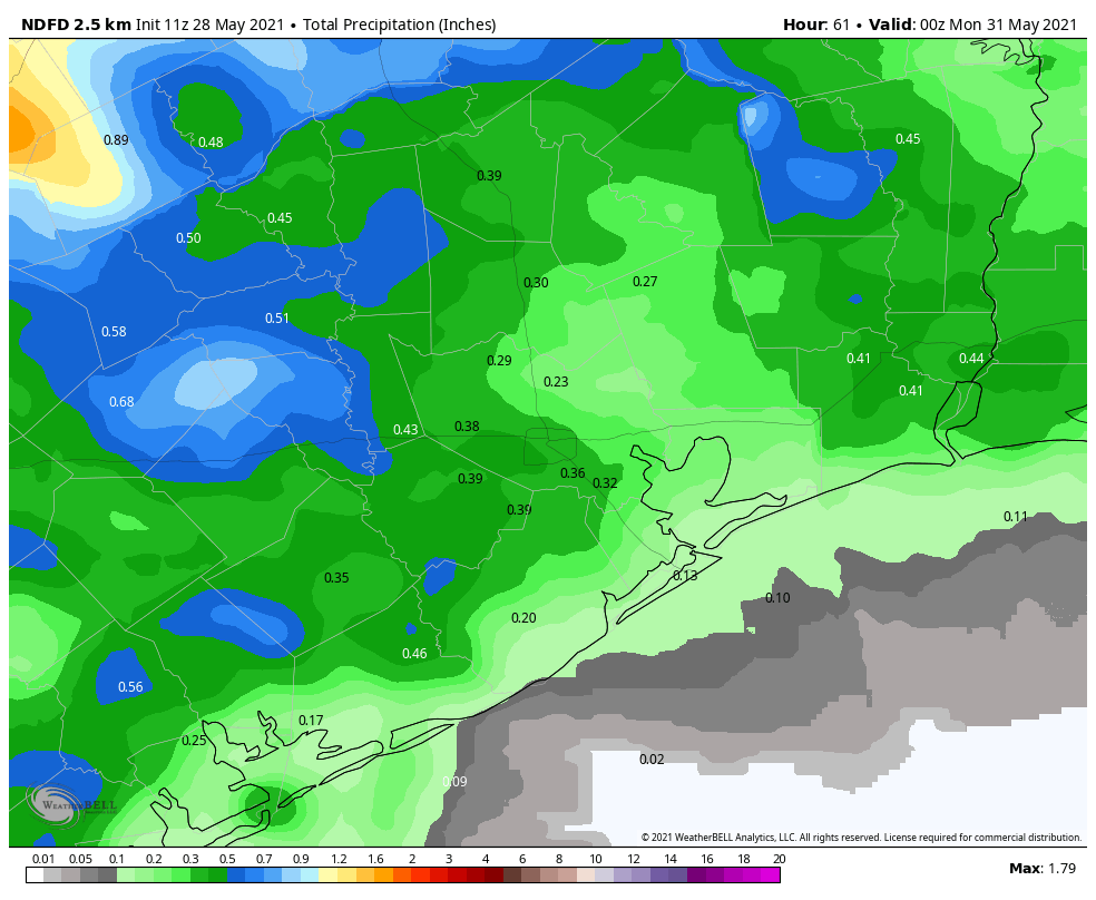
Total rainfall the next couple days will be quite sporadic, with some areas seeing under a quarter inch, possibly near-zero, and other areas seeing as much as an inch or so. The map of NWS Houston’s forecast here should be considered an “average.” (WeatherBell)

How much rain? It will vary. I wouldn’t be shocked to see some places end up with next to nothing from this and others perhaps seeing an inch or two. We don’t expect any serious flooding concerns at this time.

Sunday & Memorial Day

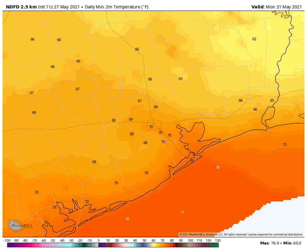
Alright, good news. Both Sunday and Monday still look good. We should see sunshine on Sunday and maybe a bit more cloud cover for Memorial Day. That cold front won’t usher in super refreshing air, but it will skim just enough off the top with respect to humidity that Sunday should be kind of comfortable for Houston in late May. Monday should be similar, but it will be a little warmer. Look for low to mid-80s on Sunday and mid-80s on Monday. Both mornings should see lows in the 60s away from the coast.

Later Next Week

Look for any vestiges of comfortable weather to disappear by Tuesday, with lows in the 70s and highs in the mid-80s. Rain chances will begin to inch up, probably just a little on Tuesday but more on Wednesday, Thursday, and Friday. It’s tough to determine the details, but another slow moving upper level system is likely boost rain chances in our area as the week rolls along. This will keep temperatures cooler than average (mostly mid-80s), but hopefully we’re able to avoid heavier rains. We’ll update this for you certainly on Tuesday, but perhaps Monday if we have any more clarity.

Meanwhile, enjoy the nicer weather later this weekend!
More sunshine today before a reasonably nice Memorial Day weekend

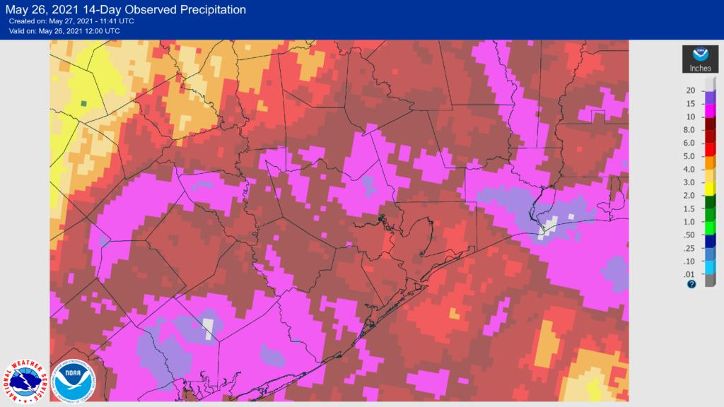
Now that we’re completely past the heavy rainfall, I want to take a look back at our totals since the beginning on May 16. From that day through Wednesday, most weather stations in the Houston region recorded at least a trace of rain, and often more than 1 inch a day. Here are the 14-day totals for the upper Texas coast. Areas in white show 20 inches of accumulation, Barney purple is more than 10 inches.

14-day rainfall accumulation map. (NOAA)

In addition to ending our region’s emerging drought, another effect of these rains has been cooler-than-normal temperatures for the month of May. Our monthly average temperature is running about 1 degree below normal, and our average high has been in the low 80s. This will soon change as June is around the corner, but it has been kind of nice.

Thursday

Houston enjoyed sunny weather on Wednesday, and that should continue today with a mix of sunshine and clouds. A few very scattered showers will be possible this afternoon as highs crank up into the upper 80s, but the vast majority of us will remain dry. Overnight temperatures will be muggy, with lows only dropping into the mid-70s.

Friday

Conditions should be similar on Friday, with continued partly sunny skies and highs pushing into the upper 80s. Sometime beginning Friday evening, or possibly not until the overnight hours into Saturday morning, rain chances will start to increase in response to an upper-level disturbance.

Saturday

Said rain chances will likely peak on Saturday morning, although we can’t be sure about timing. Overall accumulations should be higher north of Interstate 10, with 0.5 to 1 inches of rain, whereas most areas closer to the coast will likely see less than one-half inch. A few of these thunderstorms could be strong. After the rains I expect at least partly sunny skies Saturday afternoon as a (very) weak front pushes into Houston and off the coast. Highs will be in the mid-80s.

Sunday

Right now I have Sunday as the pick of the litter for the weekend. With a smidge of drier air, partly to mostly sunny skies, and highs in the mid-80s, this should be a really nice day for outdoor activities. Rain chances should be near zero.

Thanks to drier air, some locations may see lows in the 60s on Memorial Day morning. (Weather Bell)

Memorial Day and next week

Memorial Day should see a continuation of Sunday’s weather, albeit with perhaps a bit more humidity. For now I’d expect highs in the mid-80s, with a mix of sunshine and clouds. Some rain chances return on Tuesday, but for now our confidence in the forecast at that point is pretty low, and it may be Wednesday or Thursday before any rain really returns to the forecast. Most of next week will probably see highs in the upper 80s.

Only scattered showers today, with the return of sunny skies

We’re done with the organized, heavy rainfall. Really. We may still see some scattered showers today, but we’re heading toward sunnier skies and warmer weather. The forecast for the weekend remains somewhat in flux, with a chance of showers on Saturday, but overall it looks reasonably nice for the Memorial Day period.

Wednesday

The radar is quiet across the region this morning, and moisture levels have fallen. We still may see a few scattered, short-lived showers pop up this afternoon, as temperatures approach their highs in the mid- to upper-80s, but I think most of us will stay dry. Skies will see a mix of sunshine and clouds, with lows tonight dropping into the low 70s.

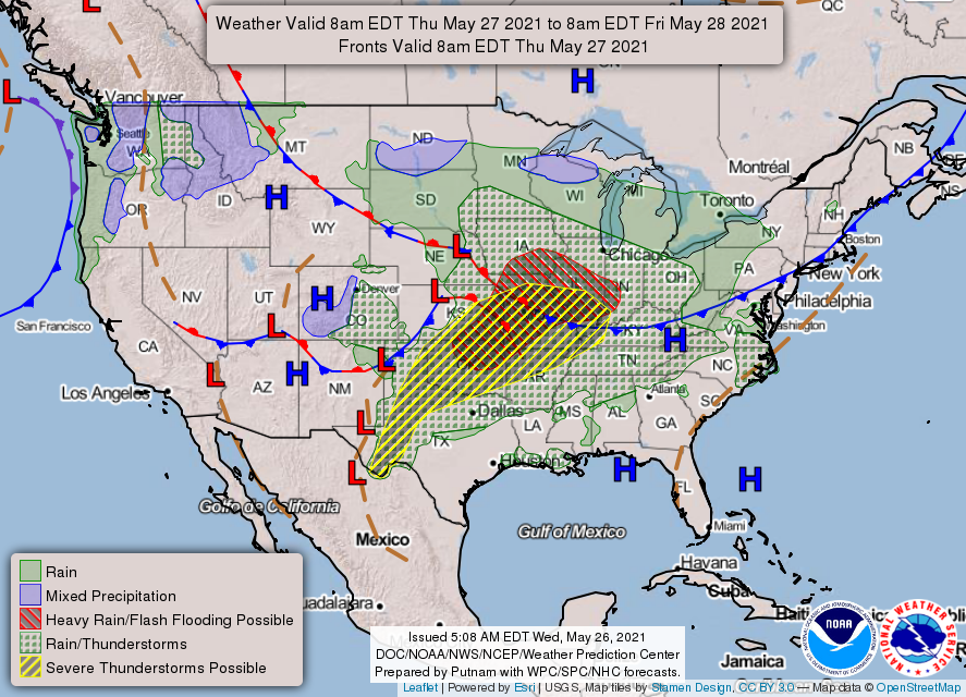
High pressure over the southeastern United States will expand into our region this week. (NOAA)

Thursday

As the atmosphere stabilizes, and high pressure expands westward into Texas, our rain chances will drop even lower on Thursday to less than 10 percent. With partly to mostly sunny skies, highs should climb into the upper 80s with only light southerly winds. Lows Thursday night will again be warm, only dropping into the low 70s.

Friday

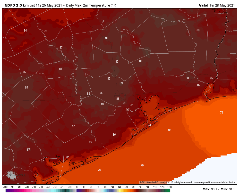
With partly sunny skies, highs on Friday may work themselves toward 90 degrees for some inland parts of the metro area on Friday. The big question is how far a weak front will get on Friday night, and what that means for our weather this weekend. For Friday, this will bring a slight chance of showers during the afternoon and evening hours for areas north of Interstate 10.

High temperatures on Friday will likely be the warmest of the week. (National Weather Service)

Saturday, Sunday, and Memorial Day

This front, and a passing disturbance, will probably drive more widespread showers and thunderstorms on Saturday morning as it pushes closer to the Houston area. In terms of accumulations, I think we’re talking tenths of an inch for most, with the better rain chances north of Interstate 10. I don’t think the showers will persist all day, as the disturbance driving them should move on.

The question, again, is what happens to the front. I think it will get shoved to the coast, of not off. If this happens we can probably expect partly sunny skies on Saturday afternoon, with highs in the mid-80s. Sunday would be rather pleasant, with drier air and highs in the mid-80s and sunny skies. Some clouds may return for Memorial Day. Rain chances look low for Sunday and Monday, as high pressure fills in, and don’t really return until the middle of next week.

Heavy rains possible again for inland areas of Houston today

Good morning. Not going to lie, the intensity of storms on Monday surprised me. First, some areas northwest of Houston saw as much as 6 inches of rainfall. Then, early on Monday evening parts of Austin County—only about 60 miles west of Houston—saw about 10 inches in a short period of time. So it’s with more than a little trepidation that I approach the forecast today.

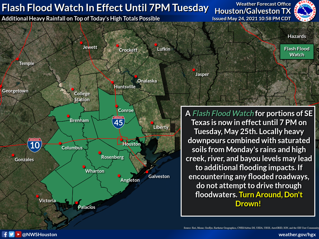
Generally, we should see fairly calm conditions this morning, with storm coverage increasing this afternoon as temperatures warm. A flash flood watch is in effect for central and western parts of our region due to the potential for additional heavy rainfall today.

Flash flood watch in effect for now through Tuesday evening. (National Weather Service)

Tuesday

The atmosphere remains plenty moist to support heavy rainfall today, particularly north and west of the Highway 59/Interstate 69 corridor. This includes the particularly hard hit areas of Austin County. In this general area we are likely to see widespread accumulations of 1 to 3 inches today, with higher isolated totals approaching 5 inches. Given the sodden soils well west of Houston, this could cause some problems both on roadways and along swollen creeks. These storms are likely to develop after noon, and wane during the evening as the sun begins to set. Highs will otherwise be about 80 degrees.

NOAA rainfall accumulation forecast for Tuesday. (Weather Bell)

Wednesday

Atmospheric moisture levels should begin to fall on Wednesday, and accordingly we expect much less coverage of showers, and less intensity where rain does fall. Overall, perhaps 30 percent of the area will see rain on Wednesday, with highs reaching perhaps the mid-80s. Skies remain partly to mostly cloudy.

Thursday and Friday

As high pressure continues to build over the area, we expect these to be mostly sunny days, with highs in the mid- to upper-80s. This should allow for the region to begin to dry out.

Saturday, Sunday and Memorial Day

Let’s start with the fact that we have questions about the weekend forecast. It will be complicated by an approaching, weak front that appears likely to stall out just north of Houston. Skies will probably start out at least partly cloudy on Saturday, and depending on the movement of the front, areas north of Interstate 10 could see some scattered showers during the afternoon and evening hours. These may even spread across the entire region. Not helpful, I know.

Sunday’s weather will also depend on the front’s position, but there is a better chance for more sunshine on Sunday. Both days should produce highs in the upper 80s. Memorial Day will probably fall on the partly to mostly sunny side of things, but overall confidence is low. Sorry, I know everyone has weekend plans, and would like some certainty.