Good evening! One of the things we’re trying hard to do this year is meet more readers in ways that are comfortable for them or they find to be the most useful for getting weather information. We’ve developed an app and started a Spanish language site, spearheaded by Houston meteorologist Maria Sotolongo. With Maria’s background in television, we’re also going to try to provide some more video content when possible. As we head into Labor Day weekend, we wanted to provide you with a quick video update on the outlook for the weekend, the latest on the Gulf tropical mischief next week, and musings about our first fall front.
Maria and Matt discuss the holiday weekend, the tropics, and longing for the first front of autumn (Space City Weather)
We certainly aren’t going to pivot away from what we do each day on both the English and Spanish language sites, which is post our morning updates and more frequent updates when it counts. That’s our bread and butter and we know it. And we definitely won’t constantly bombard you with notifications. But we are efforting to reach Houston-area folks in more ways and meet you where you are, so we will experiment with some videos like this from time to time. Please feel free to share your feedback with us in the comments or the feedback link above. I will say that it is great to have Maria here with us, and she’s been full of great ideas to continue serving you!
Just as a quick note: There was nothing earth-shattering about today’s model guidance regarding next week’s potential tropical system in the Gulf. We’re still in wait and see mode, and there is nothing too alarming at this point. But it’s September, so we’ll be watching. Look for a post probably Sunday with the latest. Meanwhile, enjoy the holiday weekend if you are able!
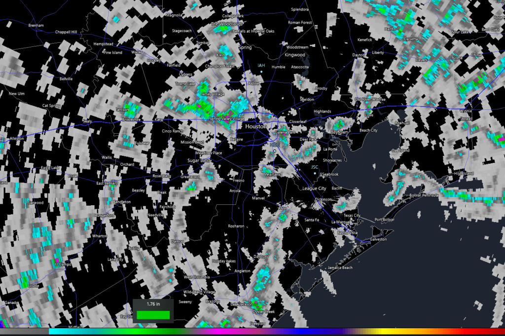
We saw some heavy rain in spots yesterday, with Spring Branch picking up almost 3 inches of rain, while the areas near Addicks, Oak Forest, and just west of The Woodlands saw 1 to 2 inches of rain.
Yesterday’s rainfall was a patchwork of nothing and 1 to 2 inch lollipops across the area. The areas is green saw 1 to 2 inches. Pink/purple indicates over 2 inches. (RadarScope)
Another mini-bullseye occurred along the Houston Ship Channel in Galena Park, as well as down near Clute in Brazoria County and in Baytown. Basically, you either got a torrential downpour yesterday or you just heard distant thunder. We’ll start the holiday weekend off on a similar note, before we turn mostly dry and hot for a couple days.
Friday
We will probably experience a similar sort of day today as we saw on Thursday. Already, there are some showers along the coast south of Galveston this morning. Watch for isolated hefty downpours across the area, but there’s probably an equal or better chance you see absolutely nothing today. Outside of the scattered downpours it will be sunny and hot. Look for generally mid-90s today with plenty of humidity.
Saturday & Sunday
Both days look primarily sunny and hot. Expect high temperatures in the mid to upper-90s, with a couple spots testing 100° or so. Morning lows will be in the 70s. Rain chances? Well, they don’t look especially high this weekend, so if you are one of the few to catch a cooling downpour, consider yourself lucky.
Labor Day
Between a weak front trying nudge in from the north (sorry, not our first autumn cold front) and increasing amounts of moisture off the Gulf, we should see rain chances perk up some on Monday. It will start off like the rest of the weekend, but watch for building rain chances in the afternoon. High temperatures will be in at least the mid-90s on Monday, possibly a tick or two hotter. Morning lows will be in the 70s once more.
Next week/Invest 91L
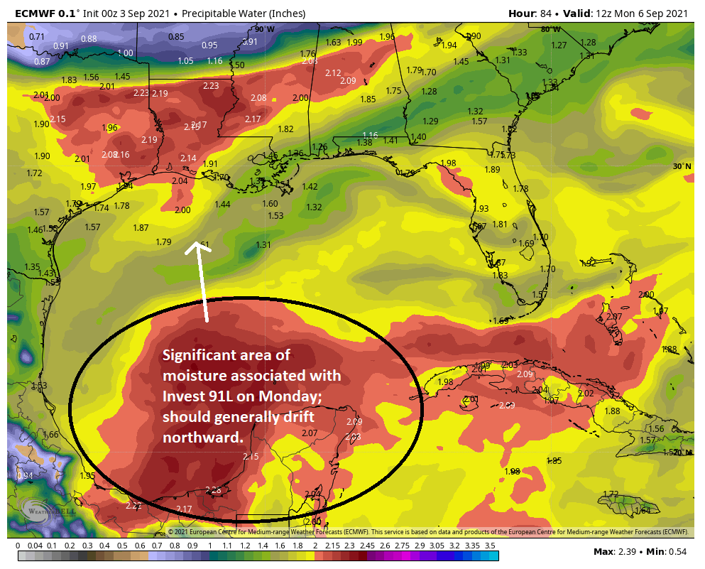
Beyond Monday, forecast confidence drops off some. We have a combination of factors contributing to this. For one, that weak front in interior Texas will still be there. Second, that area we’ve been discussing for the tropics in the southwest Caribbean is expected to move into the Gulf next week. Models continue to wax and wane on development potential with this one (dubbed Invest 91L). Last night’s models were a bit more aggressive, with both the GFS & Euro showing a likely tropical storm. But the timing is all over the place, as is the track, so we honestly can’t read much into specifics right now. But with all that moisture just sitting offshore, it does present some modest forecast challenges.
While we are unsure of what will ultimately happen with Invest 91L, we know development will probably be a bit sluggish at first and it will be dragging a significant slug of moisture north, probably just offshore of Texas through next week. (Weather Bell)
So what is the best thinking on this right now? The signals we’ve gotten from ensemble guidance and our modeling is that development of 91L, if any, should be a bit sluggish, especially early next week. The system will be bringing a healthy amount of moisture north as it drifts this way, and although most modeling shows that offshore or staying to our east, it’s much too close to write off this far in advance. We could see a couple days of more scattered storms, then a drying trend. Or we could see several days of scattered heavier storms, similar to what has occurred during a couple periods this summer. Or, yes, we could see a tropical storm type impact. Really, we don’t yet know. Our intent was to take the weekend off, but given this thing lurking, look for a post on either Sunday or Monday morning with the latest.
Regardless of what happens here, expect temperatures to step back a notch, so more like low to mid-90s, but we should continue to see warm morning and overnights. There are no signs of a meaningful autumn cold front for at least the next 10 days. But it is still a bit early.
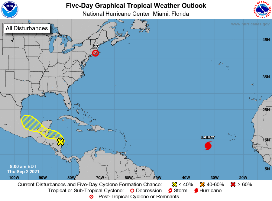
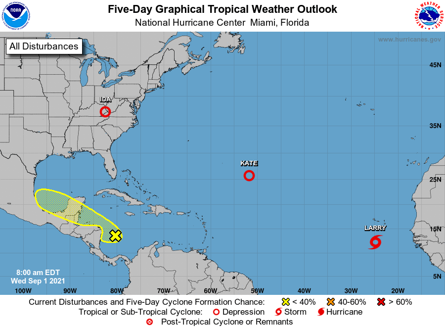
Tropics
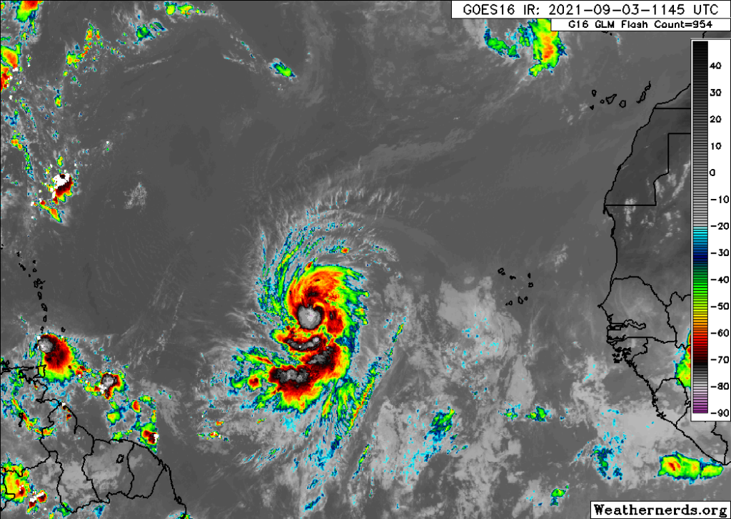
The main area for us to watch will remain Invest 91L, as discussed above. Outside of that, Hurricane Larry has 90 mph winds this morning out in the open Atlantic. Interests in Bermuda and perhaps Atlantic Canada should keep an eye on Larry.
Hurricane Larry is gathering steam, and it’s expected to become a major hurricane this weekend in the open waters of the Atlantic, no threat to the Gulf. (Weathernerds.org)
The disturbance immediately behind Larry is struggling, so for us, there are no other concerns at this time. Again, look for an update from us on Sunday or Monday. Otherwise, have a safe Labor Day weekend!
Good morning. Houston will remain in a hot, late-summer pattern with the potential for afternoon thunderstorms. Rain chances will not go to zero, but they should remain quite low over the Labor Day weekend.
In response to yesterday’s post about whether August or September had the worst weather in Houston, I conducted an informal poll on Twitter. About 70 percent of respondents chose August, compared to 26 percent who selected September. Four percent said some other month was worse.
Thursday
Temperatures this morning are quite muggy, with lows only in the low 80s for some locations. With high pressure building to the north of our region, showers will again be most likely today along and south of Interstate 10. These areas closer to the coast may have about a 50 percent chance of rain later today compared to 20 percent or so inland. Highs will generally get into the mid-90s this afternoon with mostly sunny skies. Winds will be light, out of the southeast at 5 to 10 mph.
Friday
A similar day to Thursday, with rain chances higher along the coast and lesser inland. Highs again should slot somewhere in the mid-90s.
High pressure will build over the southern United States for this weekend. (Weather Bell)
Saturday, Sunday, and Monday
Labor Day weekend looks mostly sunny and hot, with high temperatures in the mid- to upper-90s, and rain chances of 20 percent or less as high pressure more directly influences our weather.
Next week
By Tuesday or so of next week we should start to see pressures fall, which will lead to a few more clouds and should bump rain chances up into the 30 to 50 percent chance each day. This will also probably knock temperatures down into the low-90s. If you’re wondering when fall’s first real cold front might arrive, there’s still no real sign of it in the global models. Typically it comes around the third or fourth week of September.
Tropics
The remnants of Ida absolutely drenched the northeastern United States on Wednesday and Wednesday night, spawning tornadoes and causing major flooding in New Jersey and New York. While 7 to 8 inches of rain may not seem like a lot to a Houston resident, those are historic rainfall amounts for areas not designed to drain quickly.
Tropical outlook for Thursday. (Weather Bell)
As for storms over water, Hurricane Larry is on its way to becoming a major hurricane, and may eventually affect Bermuda, or may turn north before doing so. The Caribbean system we’ve been talking about still has low chances of developing, but even if it does seems likely to remain well south of Texas. We’re getting to the home stretch of the tropics for Texas in 2021, and Matt, Maria, and myself will be recording a video on Friday talking more about what the next three weeks may look like.
August is over. I always find it interesting to debate whether August or September is the worst month, weather-wise, in Houston. I’m definitely on “Team August” because it’s the hottest month with no hope of relief. But many readers loathe September more, because it’s often nearly as hot, there’s a persistent threat of hurricanes, and the wait for the first real cool front seems to take forever. I can see both sides. But I’m still glad August is over.
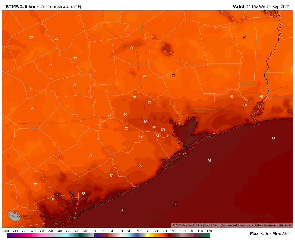
Temperatures just before sunrise in southeast Texas on the first day of September. (Weather Bell)
Wednesday
Although September is here, it definitely will feel like summer. Tuesday’s high temperature reached 99 degrees at Bush Intercontinental Airport, and today will probably be nearly as hot. Skies will be mostly sunny. Later today the combination of moisture and daytime heating should spark some showers. Chances are likely about 40 percent south of Interstate 10, and 20 percent or less inland, further from the source of the moisture. Some showers could be briefly intense. Lows tonight will be sultry.
Thursday
This day should be a lot like Wednesday.
Friday
Another day where we should see a decent chance of showers closer to the coast, with lesser chances inland. Highs will be in the mid-90s.
Saturday, Sunday, and Monday
As high pressure builds over the area, Labor Day Weekend 2021 will be mostly sunny and hot, with minimal rain chances of about 10 percent. Highs will be in the mid-90s. Plan your outdoor activities with confidence.
Next week
Rain chances should perk up by Tuesday or Wednesday of next week, and this could help to drive temperatures down into the low 90s.
The National Hurricane Center continues to suggest an area of low pressure in the Southern Caribbean Sea has a modest chance of developing over the next week, but pretty much all of our best available model guidance keeps that system bottled up in the Caribbean Sea and Southern Gulf of Mexico. We’ll continue to watch it, of course. Way out in the Atlantic Tropical Storm Larry has formed, and it likely will become a major hurricane over the next five days. It should recurve before affecting any landmasses, including hopefully Bermuda.