Houston closes the book on the warmest December on record

Through yesterday, the average temperature in Houston (Bush) is 67.5° for the month of December. Adding an expected 83 and, call it 68 today gets us to 67.8° for the month, shattering the record from 1933 by 3.4 degrees. This will also be the widest gap between warmest and second warmest of any month in Houston. Only August comes close, where the difference between the horrific August of 2011 and 2010 was 2.7 degrees. Basically, this December was Houston’s most anomalous warm month on record. There are a number of other stats and nuggets we could share, but we may save that for a separate post. Our spring fling is almost over though, and it’s time to break out the winter clothes.

Today

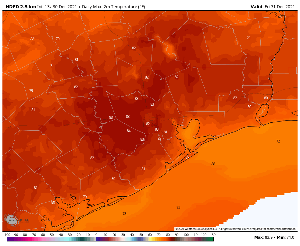
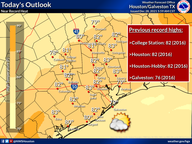
More of the same. 80s, sun, clouds, some fog this morning. Today’s record high in Houston is 82°, set back in 1974, and that seems likely to be tied or exceeded. The main difference between yesterday and today will probably be that coastal sea fog. Winds may kick up just enough today to dissipate most of it by afternoon. Look for haze and/or mist at times, however.

Saturday morning & early afternoon

Tomorrow will begin like most other days this month: Warm and humid. Look for temperatures at or above 70 degrees to start the day. It will be quite warm through the afternoon with highs pushing back into the 80s again. The 2006 New Year’s Day record of 81° seems destined to be broken.

Saturday late afternoon into Sunday

Our change in seasons will arrive in two pieces. The first will be a cold front on Saturday afternoon. This front will come through and shift winds from onshore to offshore. Onshore winds may actually be a bit stronger ahead of the front, so look for calmer conditions once the front is through. Temperatures may drop off just a few degrees. Additionally, there could be a shower or two but nothing serious.

The second piece will arrive Saturday night. Look for that to hit the northwest suburbs before Midnight and the city and southeast suburbs and coast around Midnight. There won’t be any mistaking this one.

The temperature forecast around or just before midnight will show mid-60s ahead of the front and plummeting temperatures into the 40s behind it, with even some 30s well off to the north and west. (Pivotal Weather)

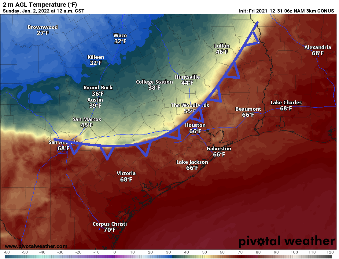
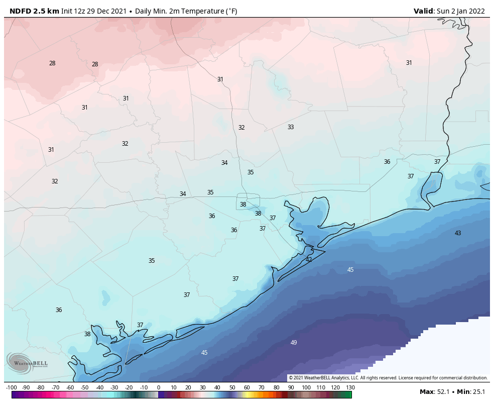
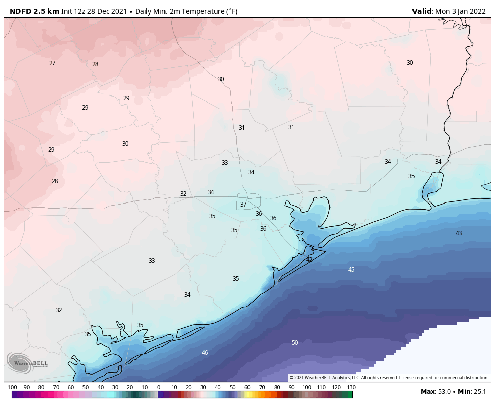
Temperatures will quickly drop from the 60s into the 40s and winds will kick up out of the north, gusting 25 to 30 mph or even a bit stronger at times. By Sunday morning, temperatures will have fallen into the 30s in most spots, with freezing temperatures north and west of Houston and even some upper-20s possible near Huntsville.

Sunday morning low temperatures will be near freezing or a few degrees below north and west of Houston, with 30s elsewhere. (Pivotal Weather)

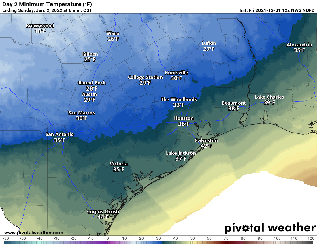
For those of you heading off to services or for a walk on Sunday morning, temperatures will be 30 to 40 degrees colder than they were on Saturday morning, and with wind chill values in the 20s, it will feel 50 degrees colder. Bundle up! The day itself should be fine, just windy and cold with highs in the mid-40s.

Monday

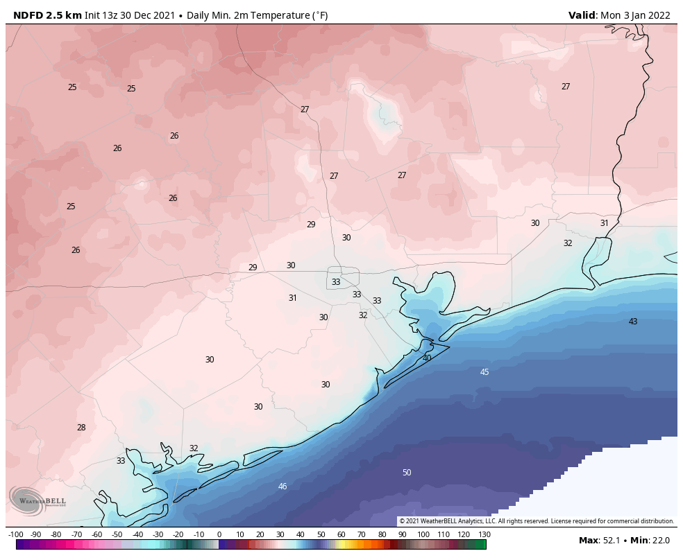
Temperatures will drop steadily on Sunday night, and we should see much of the area, save for maybe the city and immediate coast reach the freezing mark by Monday morning.

Morning lows on Monday will be near freezing or slightly below everywhere except probably inside the 610 Loop and along the beach. (Pivotal Weather)

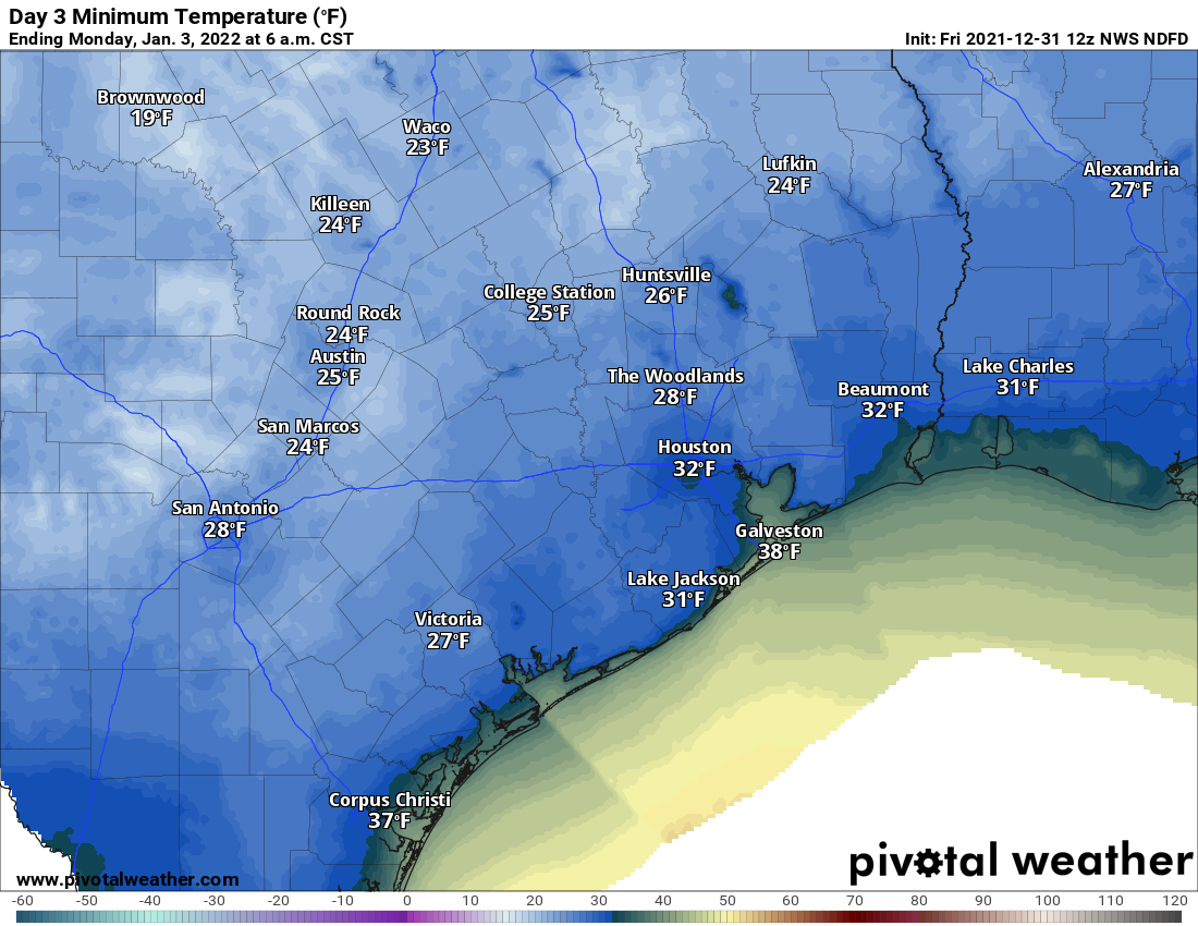
This will be a pretty standard freeze for the Houston area, the type we usually see several times a winter. Sensitive plants should be protected, particularly outside the city. If you have a sprinkler system, it’s probably also a good idea to have it shut off and drained. Typical winter preps. But as far as significant problems, we shouldn’t see any.

The rest of Monday will offer a transition back to onshore winds and temperatures bouncing back into the 50s. A freeze is unlikely Monday night anywhere in our area. This will be a quick shot of cold.

Rest of next week

Warmer weather will really be noticeable by Tuesday with temperatures warming well into the 60s. On Wednesday we warm into the 70s again. By Thursday or Friday, another, potentially much weaker front is likely to push into the area to cool us back a few degrees. Model guidance suggests another significant warm-up into next weekend before perhaps more sustained seasonably cool weather for the second week of 2022.

Final word

I just want to echo Eric’s sentiment from yesterday. It’s been a great year for us, between, among other things, launching an app, launching a Spanish language site and bringing Maria on board, being honored by the city of Houston, and arguing with each other about whether September or August is worse.

But we recognize that it’s been another rough year for a lot of folks. I am grateful for the doctors and nurses and medical research community that makes Houston a true global hub for medical research and care. Essential workers, restaurant employees, and so many others who have toiled through sickness, closures, and just mean people, thank you as well. My hope is that 2022 will offer a return to stability, both in life and weather. I’m more hopeful for the former than the latter, but either way, we’ll be here for you. Thanks for relying on us as a source of weather information to keep you and your family prepared and informed. It’s a duty and responsibility we take seriously, and we look forward to continuing doing so in 2022, which hopefully marks a return to somewhat more precedented times. Happy New Year!

The New Year will bring Houston’s first freeze of the winter season

Good morning. This will be my final post of 2021—Matt will have an update for you on New Year’s Eve of course. It has been a strange and challenging year. In terms of weather, locally, there has been good and terrible and anomalous weather. Under the “good” category I would say we’ve gone through another year without a disastrous drought, and we saw some of the nicest weather this fall on weekends that I can remember. The “terrible” category includes the extremely hard freeze and its effects in February, and Hurricane Nicholas in September, which packed a surprisingly strong punch although it could barely be classified as a Category 1 storm. Finally, the heat this December has definitely been “anomalous,” as Houston has set or tied 6 records this month, and Galveston 14, with more to come.

My wish for the new year is better weather, of course. But I’m also hopeful for other reasons. The COVID-19 pandemic is now entering its third year, and it has fractured our communities and killed our loved ones. Now, I believe that we are probably seeing a transition to it becoming an endemic disease, with less virulence, better treatments, and ultimately less transmission due to widespread immunity. Omicron is likely a harbinger of this, and hopefully will be responsible for the last major spike in hospitalizations. So while the next few weeks may be pretty terrible, I strongly believe that a brighter future awaits us. My heroes in 2021 are all of the nurses, doctors, and medical researchers who toiled to help so many, through such a difficult time.

Looking ahead, what I can say for sure, is this: A colder near-term future awaits us. Many of us will see our first freeze of the season by Monday morning, if not sooner.

Thursday

The front made it to much of the area, knocking temperatures into the 60s this morning across the area. Its effects will be short-lived, with southeast winds resuming today and highs likely to reach about 80 degrees under mostly sunny skies. Lows tonight will only drop to around 70 degrees in Houston, with slightly cooler conditions inland.

The final day of 2021 will be very very warm for late December. (Weather Bell)

Friday

The final day of 2021 will be warm once again, with highs in the low 80s and partly to mostly sunny skies. Winds will be a bit gusty, out of the south at about 20 mph. New Year’s Eve evening will be mild, with temperatures in the 70s, and partly to mostly cloudy skies. It will be plenty humid, but aside from that there is nothing to complain about as we bring in 2022.

New Year’s Day

The only real question is when the cold front will arrive. The models have been bouncing around a little bit, and now it appears that an initial front will push down to around Interstate 10 on Saturday afternoon, and be followed by a much stronger surge of colder and drier air on Saturday night. For most of the area, then, Saturday will see highs of around 80 degrees, and for coastal areas those warm conditions should persist through the evening. Some scattered, light showers will be possible during the day and overnight. Temperature wise, it will be a whole new world outside on Sunday morning, with sunrise temperatures likely in the 30s for nearly all of the area.

Sunday and beyond

COLD. It now looks as though highs probably won’t get out of the 40s for most of the area on Sunday, and with gusty northerly winds this will be a cold, sunny day if you need to be outside. Clear skies and lighter winds will lead to a very cold night on Sunday, with most of the Houston region away from the coast likely to see a freeze on Monday morning.

Freezing conditions are likely on Monday morning for much of the area. (Weather Bell)

We’ll gradually warm up next week, probably reaching the 70s on Wednesday, with another cooldown Thursday. Details to come. Happy New Year, everyone!

Inland areas may see some drier air tonight, but as for the rest of us …

Another day, another handful of records set for both high temperatures and warm overnight conditions. As of 6 am this morning, the temperature at Hobby Airport is 75 degrees, a staggering 30 degrees warmer than normal for late December. A weak front will approach the area and bring some drier air to inland areas tonight, but I don’t think these conditions will reach as far as Highway 59. After this front washes out we’ll see warm weather until a strong front arrives on New Year’s Day.

Wednesday

Today will see partly to mostly sunny skies, with temperatures rising into the low- to mid-80s. Winds will generally be light, out of the southwest. The aforementioned front will sag southeastward this evening, likely reaching College Station a few hours before midnight, and maybe as far as Katy and The Woodlands by around sunrise on Thursday. Otherwise, it will be another warm and muggy night.

This map of dewpoints at sunrise on Thursday offers a good approximation of how far the dry air will reach. (Weather Bell)

Thursday

Inland areas behind the front may stay in the 70s on Thursday, but most of the rest of the region will be back around 80 degrees. Skies should turn partly to mostly sunny in the afternoon after a cloudy start. Thursday night will be, you guessed it, very warm.

New Year’s Eve

The final day of 2021 will see partly sunny skies and very warm temperatures in the low- to mid-80s. The evening will be mild for any festivities, with temperatures in the mid-70s and likely mostly cloudy skies. A very slight chance of light precipitation comes into the forecast after midnight.

New Year’s Day

Change is on the way in 2022. After a muggy morning, it now looks like the front will reach inland parts of Houston by Saturday morning, and likely push down to the coast by around noon or shortly thereafter. This is a little sooner than our previous forecasts. Some light rain is possible with the front, but it may well be a dry passage. Colder air moves in quickly overnight, with temperatures dropping into the 30s by Sunday morning. A freeze is likely for inland areas, although the “freeze line” will remain in flux for some time yet.

Check out the low temperatures for Sunday, January 2. (Weather Bell)

Sunday and beyond

Sunday will be cold, with a northerly wind and highs likely topping out at around 50 degrees. This will feel especially cold after the very warm December weather, and Monday night will again flirt with a freeze. We’ll gradually warm back up to the 70s by the middle of the week, but another front by Thursday or so should cool us down again toward the end of next week. Rain chances remain low throughout the period.

This December will rank among the 10 warmest Novembers in Houston

Good morning, all. Just a quick post today as the forecast has not changed all that much—we’ve got five warm and muggy days before a significant cooldown arrives on the first day of 2022. Speaking of winter heat, how warm has this December been? By the month’s end it will rank not just as Houston’s warmest December in more than 120 years of records, but also among the top 10 warmest Novembers.

Tuesday

Skies will be partly sunny today, with morning lows around 70 degrees rising into the low 80s this afternoon. Winds will be noticeable, out of the south, gusting up to about 20 mph. Yesterday we mentioned the possibility of some scattered, light showers for today, but now I don’t think those will materialize. Temperatures tonight will, again, be very warm for December.

Another day, and more record heat is on the way. (National Weather Service)

Wednesday, Thursday, and Friday

More of the same with continued partly sunny skies. The only noticeable change will be the approach of a moderate cold front from the northwest later on Wednesday, but I don’t think that will make much of a dent for areas east of Katy and south of The Woodlands. If you live in such inland areas, enjoy the briefly drier air and slightly cooler morning on Thursday. Otherwise we’re continuing to look at highs in the low 80s. Each day will carry about a 10 or 20 percent chance of very light showers or misty rainfall. If you’re going to be out and about for New Year’s Eve, the weather will cooperate, with warm temperatures in the 70s, and little to no chance of rain.

New Year’s Day

The year of our Lord 2022 will dawn warm and muggy, just as the previous year ended. Skies should be partly sunny, with highs once again in the low 80s. However at some point during the afternoon, evening, or overnight hours a strong front will sweep through. At this point the front is trending drier, so maybe it will bring just a smidgen of rain with it, and maybe not. But there will be plenty of colder and drier air.

Here’s an early look at potential low temperatures on Monday, December 2. (Weather Bell)

Next week

Sunday will be cold and windy, with highs likely topping out in the 50s. Sunday night will be the coldest of the year—sorry, I couldn’t resist that—with temperatures probably dropping into the 30s for most of Houston. A freeze is possible, and perhaps even likely for at least inland areas. Then begins a slow warmup, with temperatures rebounding into the low 70s by mid-week. Another front may arrive at that point. In other words, it may feel decidedly more winter-like for awhile.