State of Texas to feel the heat from the Valley to the Panhandle

Good morning. Houston has a couple of more days in the upper 80s before our temperatures spike this weekend. It will feel a lot more like July in Houston than May as highs push into the mid- or possibly even upper-90s as high pressure reigns.

Wednesday

Like the last couple of days, today will bring warm and breezy conditions to the region. A few isolated showers may pop up, but for the most part we’ll simply see cloudy skies this morning before some clearing during the afternoon. With partly sunny skies, look for high temperatures to pop up into the upper 80s, with southerly winds gusting up to 20 or 25 mph. Clouds return this evening, with another warm night in the mid-70s.

Thursday

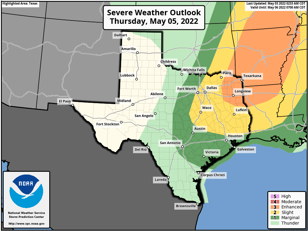
On Thursday, an upper-level low pressure system will start sliding toward our region, and this may provoke a day and night of more dynamic weather. The day will start mostly cloudy, with more southerly winds. It looks as though a line of storms will approach and move through our region during the afternoon and evening hours, although I think it will probably be weakening as it arrives. This may briefly produce some strong straight-line winds, and we can’t entirely rule out hail or a tornado. But overall, the setup does not look all that favorable for severe weather.

NOAA rain accumulation forecast for now through the weekend. (Weather Bell)

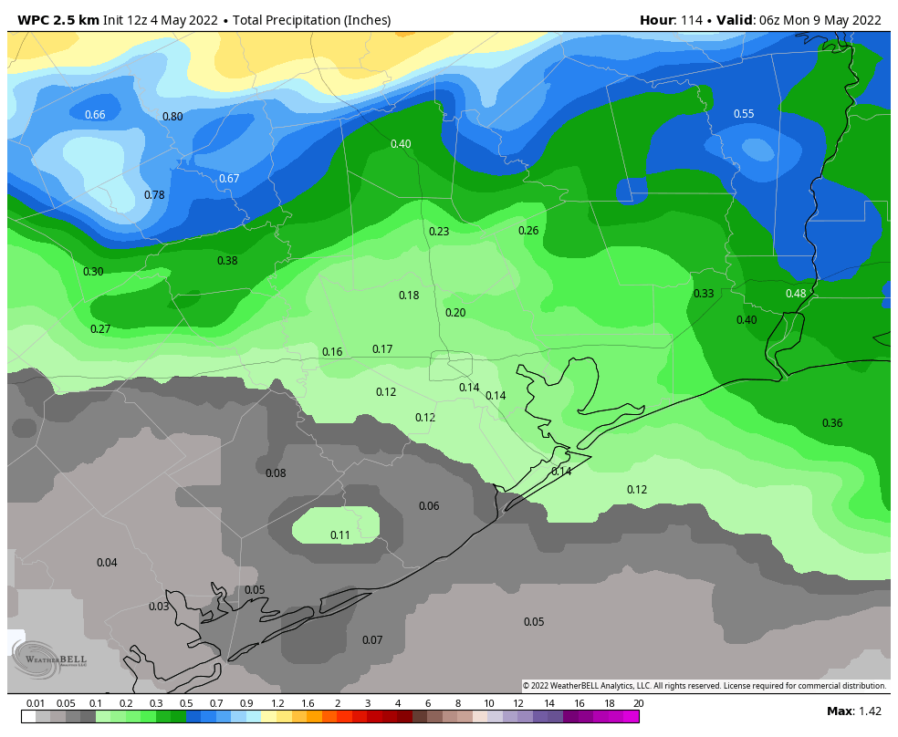
Rain accumulations through Thursday night will probably be fairly slight, on the order of a tenth of an inch or two, but there probably will be a few pockets of heavier rain. Highs Thursday should reach the upper 80s despite the clouds.

Friday

As skies clear out, we should see high temperatures push into the low 90s on Friday. Winds will be light, out of the south.

Saturday and Sunday

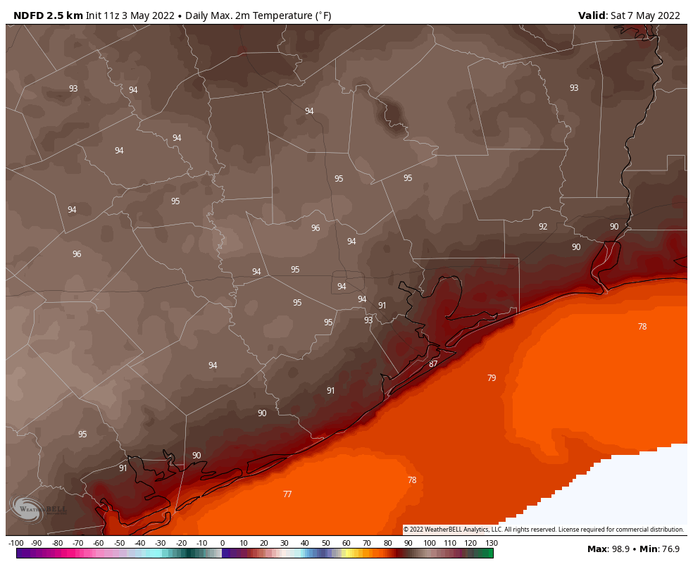
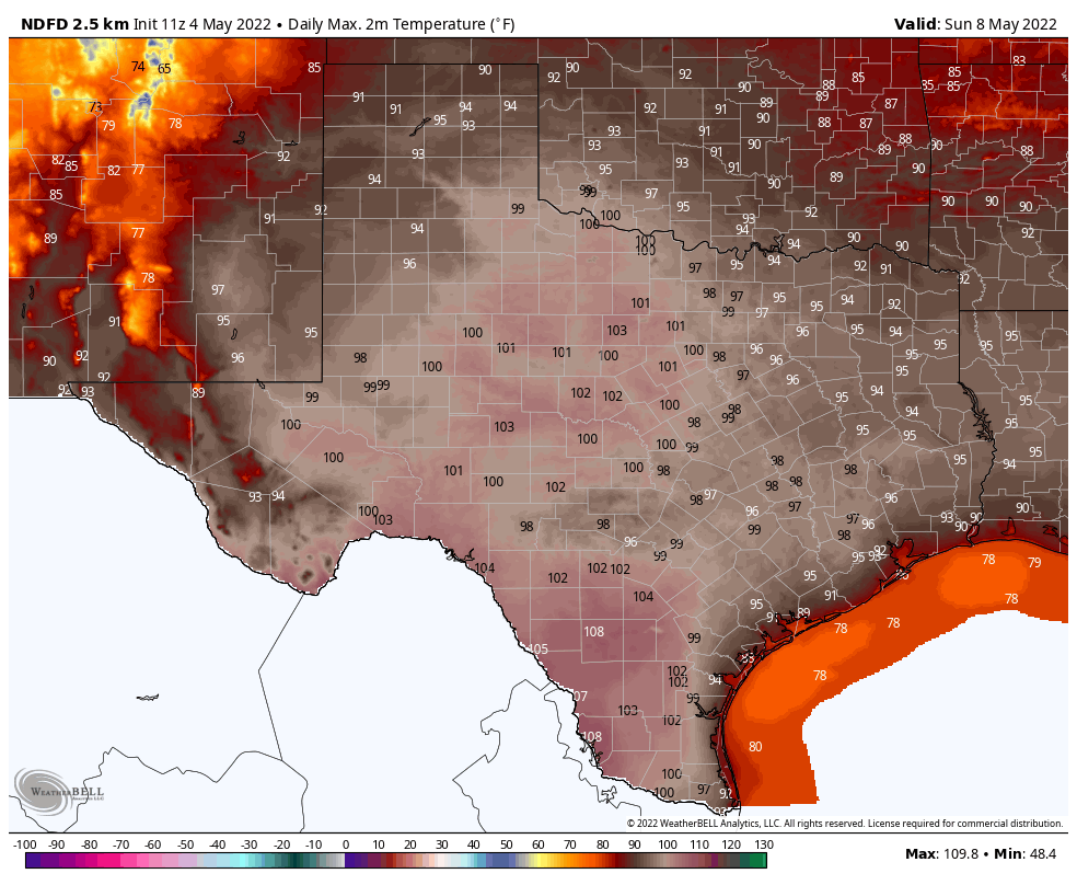
As we’ve been discussing, this weekend looks hot. Beneath the influence of high pressure, it will feel more like late July than May, with highs in the mid- or possibly even upper-90s. We may well tie or set record highs on both days. And there will be nowhere to go for relief in the state of Texas, with blazing temperatures from east to west, north to south. Overnight lows will only drop into the mid-70s.

Forecast high temperatures on Sunday in Texas. (Weather Bell)

Next week

Temperatures will moderate slightly next week, with highs falling back into the low 90s, as the overall flow turns a little more southeasterly and some clouds start to return. Rain chances are next to nil for awhile, it appears.

Houston likely to hit the mid-90s this weekend

Good morning. The overall outlook for our forecast remains the same: We’ll see a breezy warm week, with a chance of showers and thunderstorms on Thursday and Thursday night as a dying front moves into the area. As high pressure settles in this weekend, look for really hot weather, with highs likely in the low- to mid-90s.

Tuesday

Skies will be partly sunny today, with high temperatures likely pushing into the upper 80s. Southerly winds will again be noticeable at around 15 mph, with gusts to 25 mph or even higher. There may be a few scattered to isolated showers and thunderstorms, but overall chances are quite low. Skies will be mostly cloudy tonight, with lows in the mid-70s.

Wednesday

This will be a day a lot like Tuesday.

NOAA storm outlook for Thursday and Thursday night. (NOAA)

Thursday

A “cold” front will approach our region on Thursday, but I hesitate to call it that because the front will not bring much of a change in our temperatures or humidity. However it will destabilize our atmosphere, and bring a chance of thunderstorms and potentially severe weather to the northern part of our region. Overall rain chances are probably about 50 percent for areas inland of Interstate 10, and 30 percent for areas south. Highs Thursday will probably top out in the mid-80s. Lows Thursday night will again probably be in the mid-70s.

Friday

As skies clear up, we’ll see temperatures rise to about 90 degrees on Friday. Winds will remain from the south, but should be a more moderate 5 to 10 mph.

Saturday and Sunday

As mentioned, the weekend looks downright hot. For most of the region, highs should slot somewhere in between 90 and 95 degrees, and with the humidity it’s going to feel like full-on summer in Houston. Congratulations to those who celebrate. Apologies to those who suffer.

Saturday’s high temperature forecast: Hello summer! (Weather Bell)

Next week

Highs will likely slowly moderate next week, especially with the return of some clouds, but highs should remain at about 90 degrees. A cool front may bring some relief in the Thursday or Friday time frame of next week, but please don’t hold me to that.

By this weekend, it will feel a lot like summer in Houston

Welcome to May, a month in Houston that typically feels more like summer than spring. Before we jump into the forecast I want to look back at April’s weather, which was warmer, windier, and brought us fewer showers that are supposed to bring May flowers. The average temperature in April was 72.8 degrees, which was 2.8 degrees above normal. The winds, perhaps the most recognizable feature last month, averaged 11.0 mph, which is more than 2 mph above normal. And while rainfall totals varied pretty widely, our regional drought worsened for areas south of Interstate 10. May will be warmer, but we might hope that it will be a little rainier, and a little less windy.

Monday

Cloudy skies this morning will give way to partly sunny conditions later today, with high temperatures likely pushing into the mid- to upper-80s. As an atmospheric disturbance moves through from west to east this morning, we may see a few light to moderate showers, but these should end by around noon. Winds will blow from the south at 10 to 20 mph, with some gusts as high as 25 mph possible this afternoon. It will be a humid evening, with lows only dropping into the mid-70s.

Forecast for wind gusts on Monday afternoon. (Weather Bell)

Tuesday

A similar day to Monday, with highs likely in the upper 80s and a mix of sunshine and clouds. Winds will also be notable out of the south. But whereas rain chances were about 20 percent on Monday, they’re probably 10 percent or less on Tuesday.

Wednesday

Most likely this will be another warm, humid, and windy day with highs pushing into the upper 80s. Rain chances again will be quite low.

Thursday and Friday

Our weather toward the end of the week will be partly determined by whether an advancing front makes it all the way to Houston, and down to the coast. I’m at about 50-50 on whether this happens, The front won’t bring much cooling, but it could spark a decent chance of showers and thunderstorms—perhaps 30 percent—on Thursday or Thursday night—and bring some drier air into the region. Highs both days should be in the upper 80s to 90 degrees, regardless.

High temperature forecast for Saturday. (Weather Bell)

Saturday, Sunday, and beyond

Regardless of what the front does, we can be pretty confident in a hot weekend as high pressure builds into the area. We’re talking highs in the low 90s, with lots of sunshine and ample humidity. This warm and mostly sunny pattern will continue at least into early next week.