Welcome to May, a month in Houston that typically feels more like summer than spring. Before we jump into the forecast I want to look back at April’s weather, which was warmer, windier, and brought us fewer showers that are supposed to bring May flowers. The average temperature in April was 72.8 degrees, which was 2.8 degrees above normal. The winds, perhaps the most recognizable feature last month, averaged 11.0 mph, which is more than 2 mph above normal. And while rainfall totals varied pretty widely, our regional drought worsened for areas south of Interstate 10. May will be warmer, but we might hope that it will be a little rainier, and a little less windy.
Monday
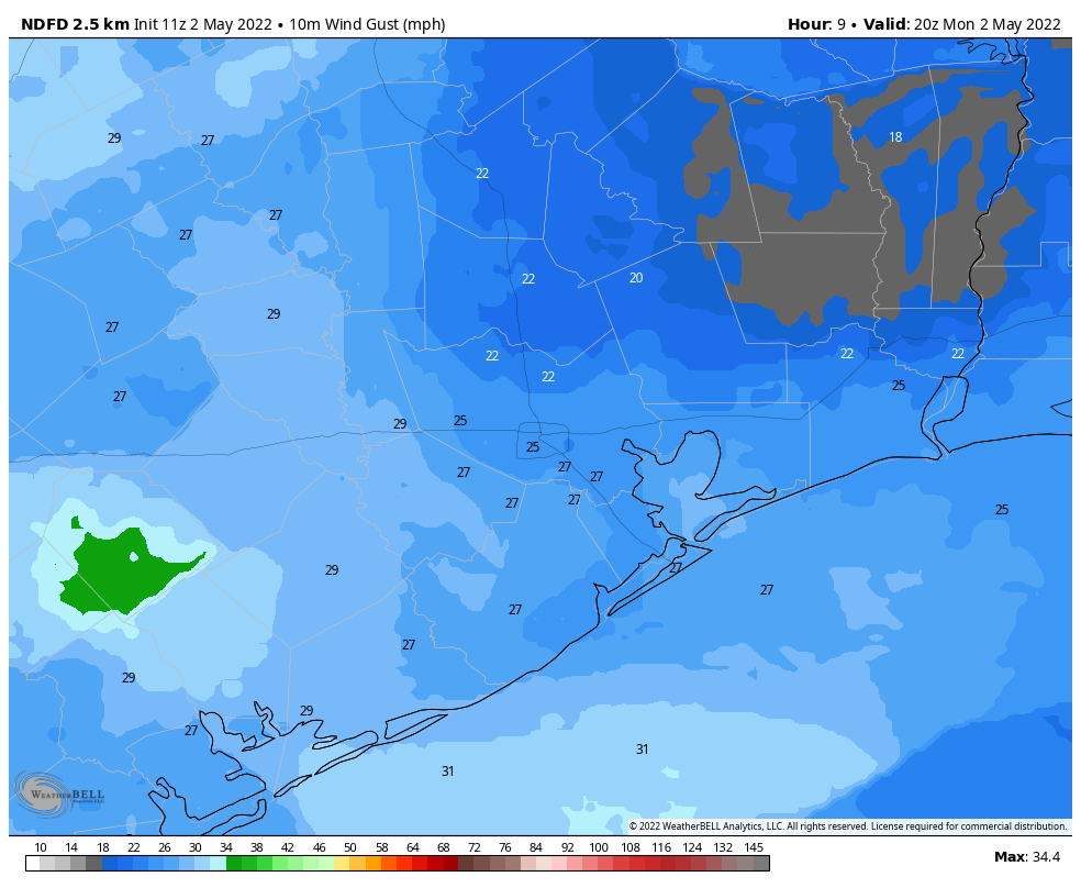
Cloudy skies this morning will give way to partly sunny conditions later today, with high temperatures likely pushing into the mid- to upper-80s. As an atmospheric disturbance moves through from west to east this morning, we may see a few light to moderate showers, but these should end by around noon. Winds will blow from the south at 10 to 20 mph, with some gusts as high as 25 mph possible this afternoon. It will be a humid evening, with lows only dropping into the mid-70s.
Tuesday
A similar day to Monday, with highs likely in the upper 80s and a mix of sunshine and clouds. Winds will also be notable out of the south. But whereas rain chances were about 20 percent on Monday, they’re probably 10 percent or less on Tuesday.
Wednesday
Most likely this will be another warm, humid, and windy day with highs pushing into the upper 80s. Rain chances again will be quite low.
Thursday and Friday
Our weather toward the end of the week will be partly determined by whether an advancing front makes it all the way to Houston, and down to the coast. I’m at about 50-50 on whether this happens, The front won’t bring much cooling, but it could spark a decent chance of showers and thunderstorms—perhaps 30 percent—on Thursday or Thursday night—and bring some drier air into the region. Highs both days should be in the upper 80s to 90 degrees, regardless.
Saturday, Sunday, and beyond
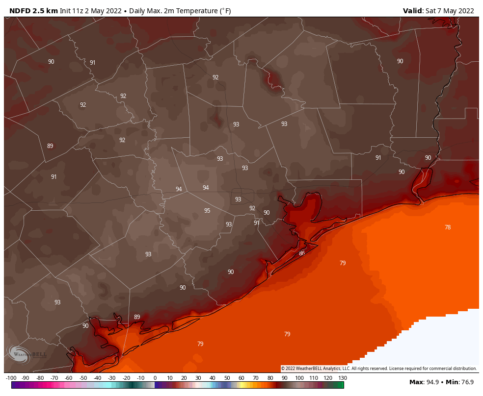
Regardless of what the front does, we can be pretty confident in a hot weekend as high pressure builds into the area. We’re talking highs in the low 90s, with lots of sunshine and ample humidity. This warm and mostly sunny pattern will continue at least into early next week.
I was just outside. t’s 76 degrees before 7 AM.
Trust me, it IS summer.
Wind, wind, wind, wind…….when do we get a break from this? I’ve been paying close attention to the wind, and it’s been abnormally windy since last October. Our deck chars blew over this morning….I cannot recall the last time in Houston during a non-hurricane even that has happened.
Yes, I have had the same problem, with potted plants blowing over, and outside chairs blowing over, and I have the windows open so everything blows off the windowsill. I haven’t noticed it starting in October, but definitely from January. I ride a bicycle or motorcycle everywhere, so I feel it. I’ve been working on putting my kite back together.
Fewer April showers —> fewer May flowers —> fewer pilgrims.
Would you consider doing a special post going in depth about why it’s been so windy this spring, and what would impact it getting more or less windy in the future?
Wind and little rainfall spell danger for trees, the shade trees we all search for when seeking respite from the brutal summer sun. Pull out a hose and give all your trees long drinks of water once a week if they haven’t had an inch of rain for 7 days. My trees get all my watering energy/resources not my St Augustine, which seems to hold its own. Your trees will thank you with cooling shade.
May is supposed to be WET, not like July or August! The forecast where we live in west houston is looking more like early July with highs in the mid 90s and lows in the mid 70s! Help!
yeah i was hoping for a May 2021 repeat and sadly i am disappoint. Needs more upper level lows this time of year. This current pattern is too much like summer and not enough like spring!!
My biggest concern starts at the end of May through November. Summers in Texas are becoming painful.
Same here on the wind front. When will it stop?
Goodness. The wind is not that big a deal. It actually benefits us by moving the hot blanket of air we have now. For all the grousing, you’d think we were having cyclones off the Bay of Bengal. (FYI: we are not.)
It is a much bigger deal that it is so warm so early – and the drought.
Actually the wind is a big deal, because trees don’t belong in Houston, and they will blow over onto your house. Also, if you ride a bike everywhere, you really feel it. I have to wonder if there is a hurricane or tropical storm this year how that will go, considering that we’ve had gale and tropical storm force winds all the time.
Trees don’t belong in Houston???? What?
To be fair, We live in the Coastal Prairie. Trees traditionally would have been more limited to bottomlands and other areas along streams or water sources. Our heavy clay soil is, traditionally, not overly permissive to forest growth over tall-grass prairie. People have certainly changed that ecology but no, trees don’t belong in many of the areas that we decided to put them away from water sources and silty soils.
You do realize that Houston spans more than the Katy Prairie and the costal plains, right? The N/NE sides of the Houston area are part of the Piney Woods (or former vestiges of it). It is a big city with diverse ecology! Being someone who lives among the trees, I’ve had visitors remark – “where did all the trees go?” as we headed SW through the other parts of the city. Its a dramatic break – tall pines a small transition then prairie.
I will summarize this the best that I can. The strong winds this year have been the result of a strong temperature difference between the cold polar air and the warm tropical air over the Continental United States.This spring there has been an even stronger contrast between the cold and warm air than normal. As these 2 air masses collide, a surface low is usually created due to the warm air rising over the cold air. The rising air at the frontal boundary creates a void at the surface, so air from all the surrounding areas will rush in to fill that void, thus creating wind. The stronger the temperature contrast is, the stronger the low pressure system will be, which results in stronger wind speeds. It’s easier to understand when looking at a surface map to help visualize what’s going on. I’m sure Matt or Eric can explain it better than I can.
Thank you!
Yikes!! Can u believe it was below 32 just 7 weeks ago and now it’s almost turning into full on summer?? I’m starting to see mid 90s in the forecast. It’s too early to be this hot in May. I just wanted a spring that lasted 3 months, not this truncated seasonal transition that lasted less than a month. At least the mighty storms this weekend kept drought out of Montgomery Country but it could be a very hot summer this year. Last summer was incredibly mild!!
Also the winds typically die down once the subtropical high sets in over Texas, usually in mid to late June.