Our first full day of autumn will feel more like August

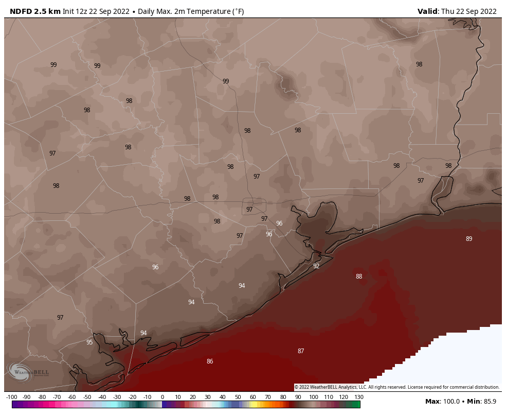
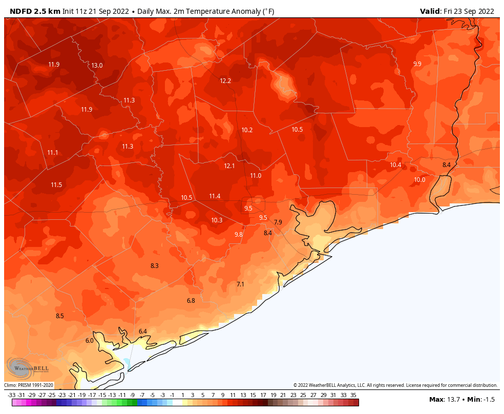
Autumn. August. Both are basically the same, right? We hit 98 degrees officially in Houston yesterday, our hottest late September day since 2005. We have a shot at meeting or exceeding that level again today and maybe again on Monday before we can hopefully be done with this level of ridiculous heat.

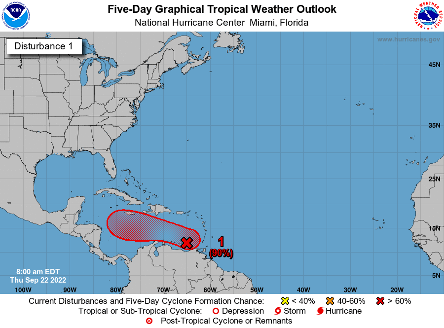
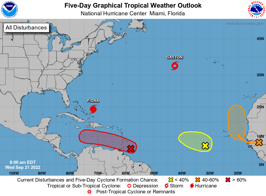
Meanwhile, Invest 98L became Tropical Depression 9 in the Caribbean overnight. It should not impact Texas, but it will likely be an issue for Florida or the eastern Gulf. More on that below.

Today

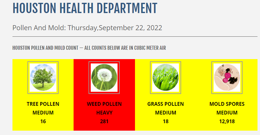
More of the same. Highs likely just shy of 100 with sunshine. Watch for poor air quality (high ozone), in addition to high levels of <ah choo!> ragweed.

Ragweed is a scourge, and it may be making your life miserable right now. Thursday’s pollen count from the City of Houston was unpleasant. Today’s will be similar. (City of Houston)

Weekend

Temperatures may crawl back a couple degrees this weekend, but that’s because humidity levels may increase just a bit. All else equal, it will continue to feel more like summer than fall: Mid-90s by day, mid-70s by night. A shower can’t be entirely ruled out, especially Sunday, but you’d be lucky if you saw one.

Monday

This may be the trickiest day of the forecast. We are expecting a cold front to descend on southeast Texas on Monday. Air masses tend to be at their hottest immediately before a front passes through. In addition, this front will come with little moisture and minimal rain chances. With humidity likely falling through the day on Monday, we will have a much easier time heating up, assuming sunshine. I would not be shocked to see some places blow past 98 or 99 degrees Monday afternoon.

Monday’s forecast high temperatures remain in the mid-90s, but I would say there’s at least some chance for upper-90s again, especially south of I-10. (Pivotal Weather)

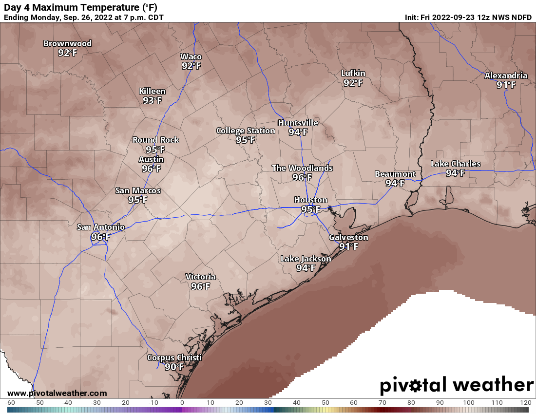
Current forecast highs are hot, but I think there’s some chance we end up beating some of these numbers.

Tuesday & beyond

The rest of next week looks nice by September standards in Houston. We should see low humidity, allowing nighttime lows to drop into the mid or lower 60s away from the Gulf and bays. Inland locations even have a shot at 50s!

In addition to the color table on the map above, Thursday morning’s actual forecast low temperatures are screaming pumpkin spice everything. (Pivotal Weather)

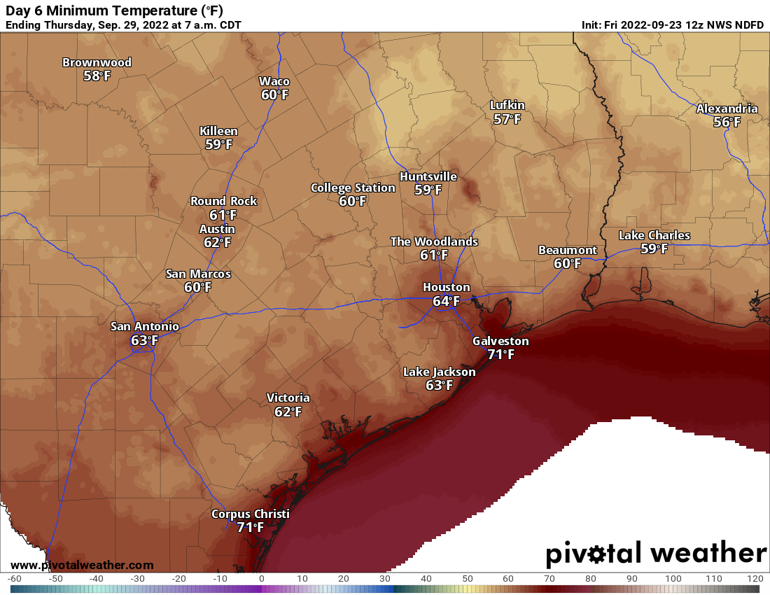
Daytimes will remain fairly hot, but not nearly to the levels we’ve seen lately and with much more tolerable humidity. In other words, the shade and a breeze should offer to provide sweet relief from heat. Look for upper-80s to 90 or so each day. Rain chances seem close to zero all of next week.

Tropics

So now we’ll discuss the tropics. Again, we do not expect that Tropical Depression 9 will impact Houston or Texas at all. So what will it do?

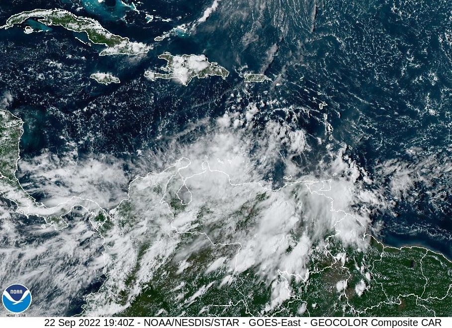
This morning, TD9 is located just off the coast of Venezuela. It finally pushed away from land and more out into the water yesterday, which has allowed it to organize.

Tropical Depression 9 is organizing off the coast of Venezuela, though it is still experiencing the effects of wind shear, which will keep initial development slow. (Weathernerds.org)

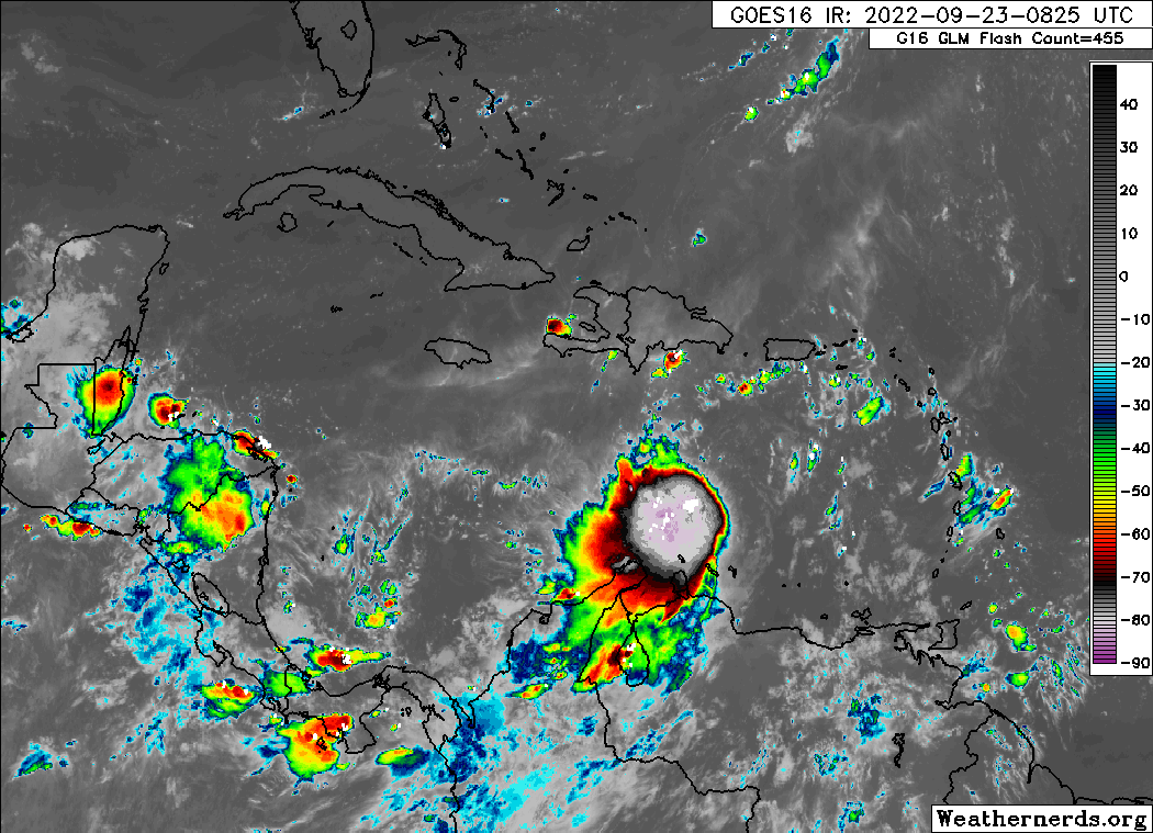
Granted, it doesn’t look great on the satellite image above. There is still a lot of wind shear in the wake of Hurricane Fiona, which is impacting TD9’s growth. It will initially be slow. As TD9 works west, it should emerge from that shear into a more stable environment, and that’s when we may see it intensify more rapidly.

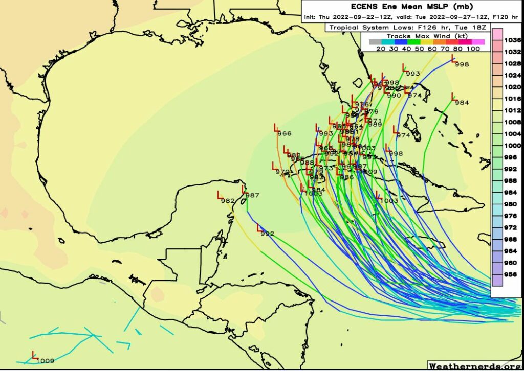
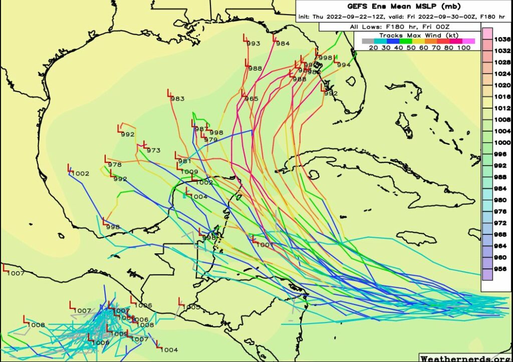
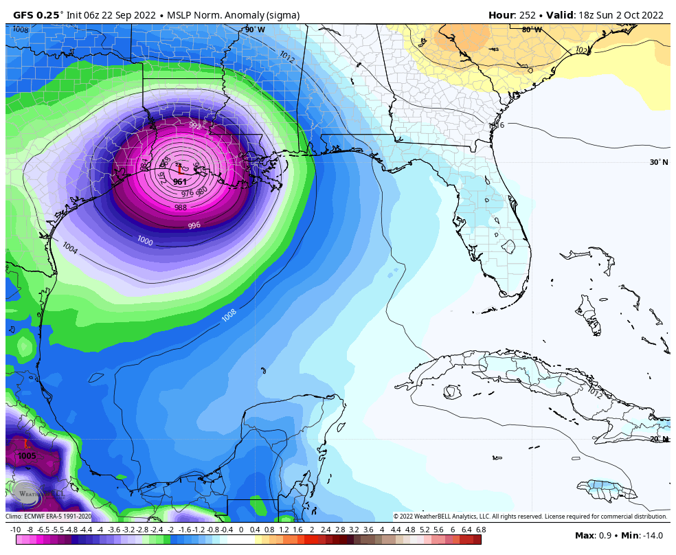
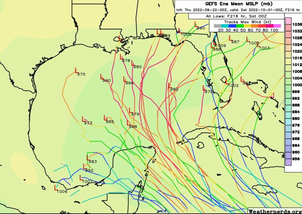
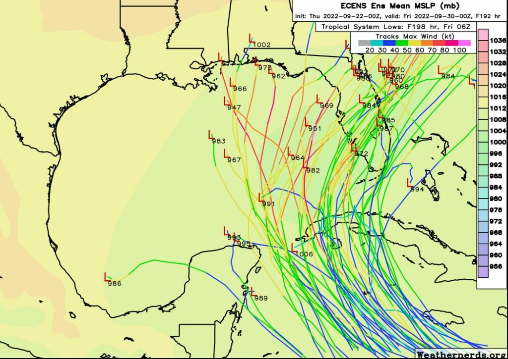
TD9 is expected to work just north of west over the next couple days, but it will eventually likely feel the impacts of our cold front and resultant trough over the Eastern U.S. by early next week. This will allow the storm to turn northwest and eventually north and probably northeast as well in time. Thus, the track forecast for Nine shows it threatening Florida in time.

Tropical Depression 9 will develop into a tropical storm this weekend and probably turn north once it gets past Jamaica. Exactly where that turn occurs and how much land interaction is experienced by TD9 will help determine how strong it gets when it arrives near Florida. (NOAA)

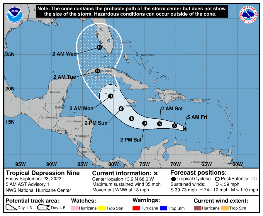
Given the geography of Florida and the Caribbean and the turn expected from TD9, there are many, many questions on intensity and impacts. If the turn happens earlier than forecast, that could lead to more land interaction with Jamaica and Cuba’s eastern mountains, which could keep the system a bit disheveled and also allow it to track east of Florida. If the turn is slower, this could give TD9 more time over the Caribbean rocket fuel (mostly normal for this time of year), allow it to strengthen more, and produce less hostile land interaction. Thus it would be a bigger threat to the Florida Peninsula. If the turn is much slower than forecast, then odds increase for the Panhandle or Mississippi/Alabama coasts. All options are reasonable right now, but consensus favors something near the current NHC track.

Given the general interest in this system, as well as the potential impacts to the planned Artemis I launch in Florida next week, Eric and I will keep you updated on this storm through the weekend.

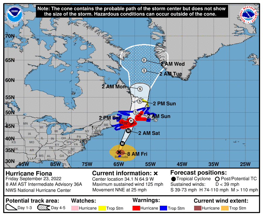
One last note. We’re obviously watching TD9 closely, but Fiona is still out there, and it is about to absolutely hammer Atlantic Canada. Much of Nova Scotia, Prince Edward Island, and Newfoundland are under hurricane warnings. Tropical storm conditions are even expected as far north as Labrador. This will likely be a generational storm for Nova Scotia. This area often experiences large storms, but this will be at another level and perhaps worse than Juan in 2003.

Fiona’s final chapter will include serious impacts on Atlantic Canada, where hurricane warnings are in effect. (NOAA)

Thoughts with our Canadian friends through a pretty trying event.

Tropics update: Invest 98L reaches Caribbean Sea, but it’s difficult to see a path to Texas

Good afternoon, all. I just wanted to jump in with an update because we’re continuing to receive a lot of questions about the tropical system that’s forming in the southeastern Caribbean Sea. I’ll put the bottom line right up top: While there remains a lot of uncertainty about this tropical system and its eventual fate, in very few of those circumstances does the storm wind up directly impacting Texas. So while we need to be watchful, we certainly should not be worried. After all, we’re planning a Fall Day celebration on Sunday, October 2, and we feel good about that despite this tropical mischief.

A tropical system has moved into the Southeastern Caribbean Sea, but it remains disorganized as of Thursday afternoon. (NOAA)

As of this afternoon, despite being afflicted by wind shear in the wake of Hurricane Fiona, the area of investigation, or Invest 98L, is moving toward more favorable conditions. A tropical depression or storm is likely to form in the next day or two, and then by late Sunday or Monday it should reach the northern or northwestern Caribbean Sea. All well and good until then, but after that is when the uncertainty kicks in. This uncertainty should diminish during the next couple of days, with the formation of a center, and hurricane hunter data. So bear with us for a little while until the forecast comes into better focus.

Three scenarios

With that said we are starting to seem some trends and I think there are three major outcomes. The most likely scenario is that Invest 98L gets pulled to the north, into the eastern Gulf of Mexico or across the Florida peninsula during the Tuesday or Wednesday time frame of next week. It could be a fairly strong hurricane at this point, or interactions with Cuba could hamper its organization. The European model is fully on board with this idea:

The European model ensembles are sympatico with the first scenario, bringing a storm to the vicinity of Florida. (Weathernerds.org)

If the storm misses this opportunity to turn northward, into a trough along the US East Coast, it could continue tracking northwest into the central Gulf of Mexico. At that point it probably would move northward, toward the coastal areas of Louisiana, Mississippi, Alabama, or the Florida Panhandle. This is probably the second-most likely scenario.

Finally, a third possibility is that the system remains fairly weak and continues tracking west, into the Yucatan Peninsula, across the Bay of Campeche, and into the Mexico mainland. In this scenario the storm would probably remain south of Texas.

The GFS model ensembles reflect the potential for other scenarios to unfold. (Weathernerds.org)

There are some freak scenarios in which Invest 98L could find its way to Texas as a hurricane, but at this point they are unlikely, and again, probably not worth losing too much sleep about. Regardless, we’re going to remain on top of the situation and Matt will have a comprehensive update on 98L, and our forthcoming front, on Friday morning. I’m starting to get excited about the dry air on the way to Houston.

Houston sees upper 90s for five more days before a front, and keeping an eye on the tropics

Good morning. Today marks the autumnal equinox, when the sun shines directly over the equator. Put another way, for the northern hemisphere today is the first day of fall. Alas, it will not feel like fall outside, but rather the dead of summer. In fact, Houston faces five more very hot, August-like days before the first real cool front of the season arrives on Monday, ushering in drier and at least moderately cooler air.

For the last few years we have dubbed the first day it really feels like fall in Houston as FALL DAY. This year that will probably be Tuesday or Wednesday. Along with our partner Reliant Energy, we thought it would be fun to celebrate Fall Day and host our first-ever in-person event with me, Matt, Maria, Lee, and Dwight. Please join us on Sunday, October 2 between 10 a.m. and noon at the Houston Botanic Garden for a fall festive meet-and-greet with activities for kids and adults. Admission is free. Look for more details soon.

High temperature forecast for Thursday in Houston. (Weather Bell)

Thursday

High pressure will peak over the region today, and accordingly we’re going to see very warm temperatures with highs generally in the upper 90s. A few locations well inland may hit 100 degrees, whereas the coast will reach the low 90s. Skies will be sunny, with rain chances right at zero percent. Winds will be light, generally out of the north, at 5 to 10 mph. Lows tonight will drop into the mid-70s.

Friday

This will be another hot and sunny day, with highs perhaps 1 or 2 degrees lower than Thursday.

Saturday and Sunday

The weekend will see continued hot and sunny conditions, but as the high pressure ridge starts to back off we can expect to see highs dropping into the mid-90s for most of Houston. There is perhaps a slight chance of showers by Sunday afternoon, but I would not bet on it.

Next week

Monday will be hot again, but after then we’re anticipating the arrival of a cold front that will bring drier and cooler air into the region. Days are still going to be plenty warm, with ample sunshine and dry air helping to keep daytime highs in the upper 80s to perhaps 90 degrees. But nights should cool off fairly quickly as the sun goes down, and lows drop into the 60s. With dewpoints in the 40s and 50s for several days it will feel noticeably different. Rain chances stay low.

The tropics

There is a lot going on, including a significant storm headed to Canada in the form of Hurricane Fiona, but for the continental United States all eyes are on a tropical wave known as Invest 98L. The system has yet to show significant organization as it is being affected by strong wind shear, but there is high confidence that this will become a tropical storm, and then probably a hurricane, over the next several days as it moves into the central and the western Caribbean Sea.

Tropical outlook at 7am CT on Thursday. (National Hurricane Center)

After that time there remains some uncertainty on the track forecast as 98L likely turns to the northwest into the Gulf of Mexico. Over the last 24 hours the premiere US forecast model, the Global Forecast System, has brought 98L closer and closer to Texas before it makes landfall in Louisiana about 10 days from now. See below for the latest GFS forecast, which is far enough out that it is probably worthless. I am sharing it for illustration purposes, however.

Operational model forecast for the GFS model shows a landfall in Louisiana on October 2. (Weather Bell)

Under this scenario Invest 98L misses a “trough” that would allow it to move north early next week, and it continues to drift into the central and western Gulf of Mexico before ultimately turning north. In this case we would be watching the system for a long time. While this is certainly possible, at this time I do not consider this a likely outcome.

Ensemble forecast tracks for the GFS model. (Weathernerds.org)

Why? Because the reality is that the GFS model’s operational run is a significant outlier at this point. The vast majority of model guidance, including many members of the GFS ensembles (shown above) and the European model (shown below), keep 98L in the eastern half of the Gulf of Mexico.

Ensemble forecast tracks for the European model. (Weathernerds.org)

Our confidence in a track forecast should improve during the next 24 to 48 hours as the global models ingest data gathered by hurricane hunters, and the center of Invest 98L starts to form. Until that time expect a fair amount of uncertainty, and we’ll accordingly continue to watch it closely.

Fall is in sight for Houston, but we’re not there yet

Good morning. The season’s first real cool front is on the horizon, but it will be a painful trek to get there. That is because the next six days will bring very hot conditions, including the possibility of 100-degree days, before the arrival of a cooler and drier air later on Monday or Monday night. Rain chances are near zero until the front’s passage.

Wednesday

As high pressure starts to tighten its grip on our weather, highs today will be in the mid- to upper-90s across the region, with sunny skies. Winds will generally be light, out of the north. Lows tonight will drop into the mid-70s under clear skies.

High temperatures on Thursday and Friday will be 8 to 12 degrees above normal. (Weather Bell)

Thursday and Friday

High pressure reaches its peak thickness toward the end of the work week, and as a result these days will bring temperatures in the upper 90s for much of Houston, with 100 degrees possible for inland areas. Some locations probably will set record high temperatures. Expect sunny skies, and light easterly winds, for the most part.

Saturday and Sunday

The ridge starts to back off some this weekend, but we’re still going to be hot and sunny, with highs in the mid- to upper-90s. Some slight rain chances return to the forecast by Sunday afternoon, but they’re probably on the order of 10 or 20 percent.

Next week

We’re still working out the details, but confidence is now pretty high—think, 80 percent or greater—that a cool front will push into the area on Monday, with notably drier air arriving overnight or by Tuesday morning. There is a chance of rain with the front’s passage, but right now it looks pretty low. I’m thinking we’ll see highs in the 80s for a few days next week, with lows perhaps in the low 60s, but we’re still a bit fuzzy on that. Regardless, it’s going to be pretty amazing, I think.

The Atlantic tropics have come alive. (National Hurricane Center)

Tropics

The tropics are popping off all over the place. Hurricane Fiona is likely to pass just west of Bermuda and then menace Canada this weekend. Newly formed Tropical Storm Gaston is expectorating all over the northern Atlantic, but is not a threat to much of anything. The system of most interest to us is Invest 98L, shown in red above, which should soon enter the Caribbean Sea.

This storm will very likely become a hurricane in the Caribbean. For us, the big question is what happens next. While it’s not possible to say so with certainty, an eventual turn northward into the Gulf of Mexico about one week from now is the most probable outcome. Those who have read this site for any period of time understand that beyond about seven days weather forecast models become a lot less useful.

Climatologically, this would be late in the season for Texas to be directly impacted by such a storm, and most of the recent modeling guidance keeps the storm over the eastern half of the Gulf of Mexico. Ultimately a lot of factors, including next week’s front, will determine the track of the storm. We’ll keep watching.