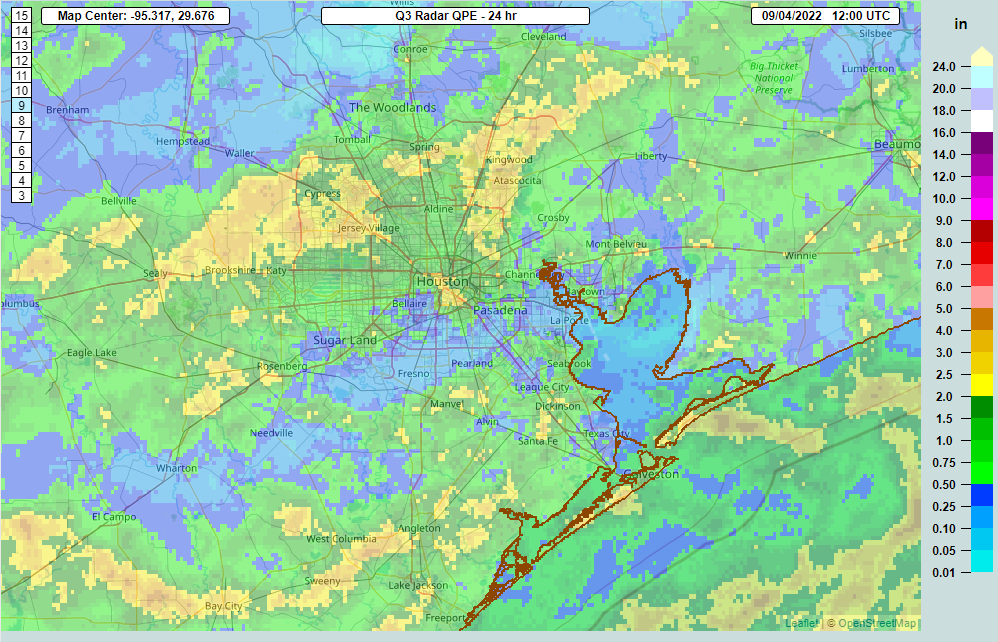
Good Sunday morning. About 60 to 70 percent of the area got a good dose of rainfall yesterday. Some places saw nearly 4 inches of rain on Saturday across Harris County.
Rain totals were highest on Saturday along the coast and north of I-10 from Brookshire through Cypress, Klein, Spring, and Kingwood. (NOAA NSSL)
Back on Friday we mentioned that Sunday’s forecast was a little trickier in that the greater concentration of rain could end up farther south of Houston. Indeed, that’s what will end up happening today. We expect the heaviest rain to be offshore much of today, perhaps building back along the coast some as the day progresses. So, draw a line from Galveston to Angleton to Bay City, and points south of that line have the highest odds of meaningful rain today.
Rainfall on Sunday will be highest offshore and along the coast, though even some coastal communities may end up seeing only a few showers and a good bit of clouds. (Pivotal Weather)
Inland areas won’t be 100 percent dry, but shower coverage may be less than it has been for a few days. Look for highs in the low to mid-80s south and mid to upper-80s north, perhaps near 90 degrees.
Labor Day
A similar pattern is expected for Monday, with the heaviest rain offshore or well south of Houston. Look for a bit more sun, a slight chance of showers, and highs in the mid to upper 80s on average.
The rest of next week looks fairly benign now, with only isolated to scattered rain chances each day.
Tropics
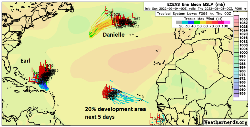
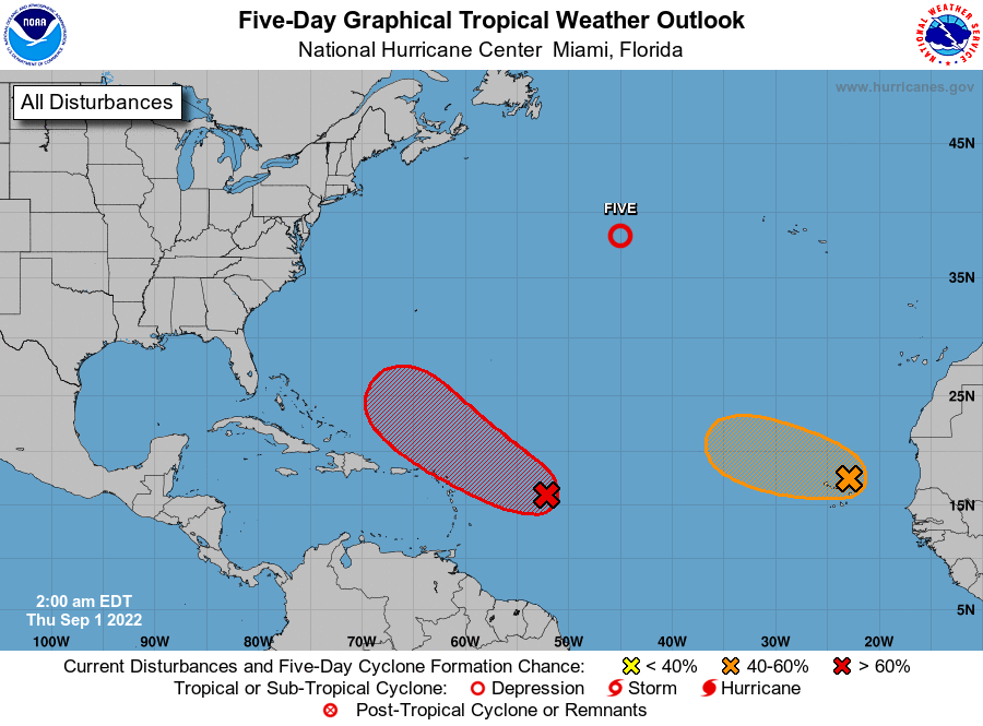
Just a quick update on the tropics today. We have Hurricane Danielle to the north and Tropical Storm Earl to the south in the open Atlantic. Neither are a threat to the Gulf or to land.
While there are two named storms in the Atlantic and an area to monitor, none are a concern for land over the next 5 days or the Gulf at all. (Weathernerds.org)
An area in the eastern Atlantic has about a 20 percent chance of developing over the next 5 days. That is also not a Gulf concern. We see nothing over the next 7 to 10 days that looks to be of concern for the Gulf. Good news!
Eric should be back posting on Tuesday, unless something changes between now and then. Otherwise, enjoy the rest of the holiday weekend!
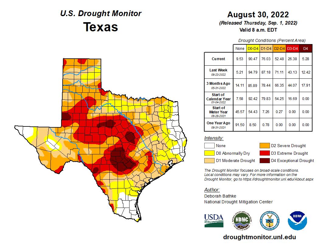
Well, here we are. As we’ve been discussing all week, a wet Labor Day Weekend is in the cards for the Houston area, as we continue to chip away at our drought and rainfall deficit all across Texas. Yesterday’s Drought Monitor report had mostly good news for Texas, with the most severe drought coverage losing about half its area, as well as improvements across the state too.
The coverage of D3/D4, extreme and exceptional drought was virtually cut in half this week across Texas. For Houston, areas west of the city remain in extreme drought as of Tuesday. (USDA, NOAA)
In our area, the only real coverage of extreme drought is west of Katy as of Tuesday, areas that have seen as much as 2 to 3 inches or so of rain since. Next week’s map should be even less ugly, as we expect multiple rounds of showers and storms across much of the southeastern third of Texas over the next few days.
Today
Much like yesterday, we should see some showers and storms pop up across the area during the afternoon, probably along the Highway 59 corridor after lunch and erratically expanding as the day progresses. Some areas will see nothing today, while others could quickly pick up an inch or two of heavy rain and see some ponding or street flooding. Highs will be near 90 degrees. Showers may linger for a couple hours after sunset before fading away.
Saturday and Sunday
With a weak cool front in our area this weekend and available moisture in the atmosphere running about 150 percent of normal, we have a very good recipe for numerous showers and thunderstorms and potentially heavy rainfall. If you have Saturday morning plans, you may be able to escape with minimal disruption, but after 9 or 10 AM, showers should begin to pop up from Houston and points south and east. The earlier you can accomplish things, the better. Storms will become more numerous in coverage on Saturday afternoon.
The entire region is under a “slight risk” (level 2 of 4) for excessive rainfall tomorrow. Rain rates of 2 to 3 inches an hour may cause streets to fill up with water rather quickly in parts of town. (Pivotal Weather)
Stick a pin over downtown Houston. Areas south and east of that pin will likely see the most coverage of rain and storms. Coverage should be pretty healthy north and west of there as well, but it may be more scattered or intermittent.
For Sunday, look for a continuation of things. Showers and storms will blossom as the morning progresses and expand across much of the area. Sunday’s forecast is a bit trickier, however, in that the front may sag a bit farther south than Saturday. This could perhaps focus more of the rain farther south of I-10 and along the coast. We’ll update you this weekend on that.
Any storms this weekend will be capable of producing frequent lightning, brief strong wind gusts, and 2 to 3 inches of rain in an hour or a bit more. This will likely lead to occasional areas of street flooding anywhere in the Houston area or along the coast. For now, no flood watch or SCW flood alert is posted, but we will be monitoring things this weekend to see if that needs to change. Bottom line: Assume that if you’re under torrential rain, it will stay there a bit and could flood the streets for a time.
On average expect 1 to 3 inches of rain this weekend across much of the area. Some will see less, others could easily see 4, 5, or even 6 inches of rain, depending on exactly how storms setup. (Pivotal Weather)
We are expecting about 1 to 3 inches of rainfall through Monday morning across the area. Important: On average. Some places will almost certainly see less, while others could easily see 4 to 6 inches of rain or even a bit more, depending on exactly how things setup. At this time, we expect those bullseye areas to be relatively small geographically, but we are not sure exactly where those will occur.
Clouds and showers will keep temperatures down this weekend, and at best we will probably see mid-80s for highs and 70s for lows.
Labor Day
If it does not happen on Sunday, the better support for storms should shift south of Houston on Monday, but I still do think we’ll have some rainy periods to contend with even in the city and north. I wouldn’t postpone outdoor plans, however. We’ll keep you posted this weekend. High temperatures should be mid to upper-80s, with lows in the 70s.
Rest of next week
While no days look to be washouts, we will probably deal with daily showers and storms most of the rest of next week. Temperatures should be fairly steady in the upper-80s to low-90s most days, with humid mornings in the 70s.
Tropics
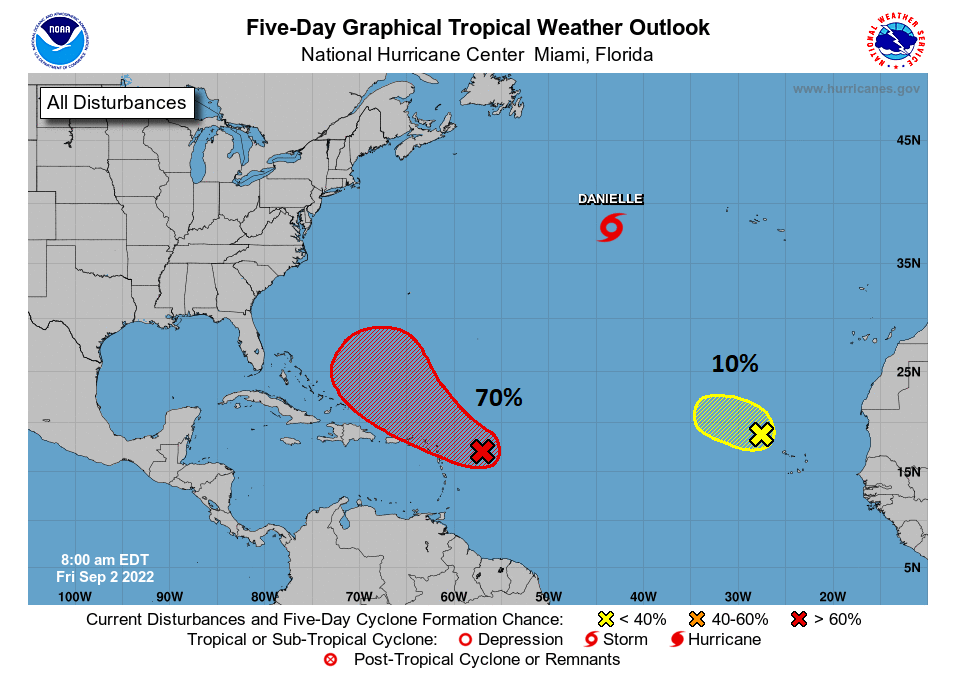
The good news: We have no concerns in the Atlantic for Texas. Tropical Storm Danielle formed yesterday, and it is destined to become a hurricane later today. Naturally, it’s occurring right where we all expe—oh, way up in the far northern Atlantic Ocean. Okay then. None of the other waves being monitored in the Atlantic by the National Hurricane Center are expected to get into the Gulf.
Tropical Storm (soon to be Hurricane) Danielle and the two tropical waves being watched in the Atlantic are of no concern to Texas or the Gulf. (NOAA/NHC)
The intrigue: A tropical wave designated as “Invest 93E” in the Pacific off the south coast of Mexico is expected to develop into a tropical storm or hurricane in the coming days. It will curve north and toward Baja, and its leftovers should eventually end up over Mexico and either the desert Southwest or perhaps Texas. Obviously it won’t be a hurricane at that point, but we don’t know exactly how that system will impact our rain chances later next week or weekend, if at all. But options ranging from higher rain chances to very low rain chances, or even some scattered strong thunderstorms are on the table.
Invest 93E is located off the south coast of Mexico in the Pacific Ocean. While it won’t be a Gulf threat, we will be watching its future to see if any remnant moisture can arrive in Texas late next week or weekend. (Weathernerds.org)
We probably won’t get much visibility on this until early next week. We’ll keep you posted.
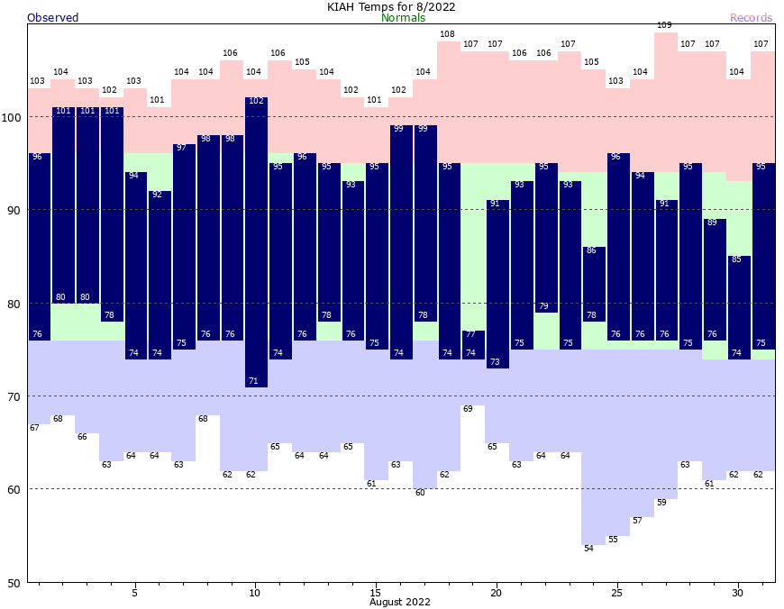
August is almost invariably the worst month of the year, weather-wise, in Houston. Temperatures are either blazing hot with drought-like conditions, or we see flooding due to tropical moisture. Our air is often at its muggiest during the month. And almost always we see our most sweltering days and warmest nights of the year during the eighth month of the Julian calendar, named after the Roman emperor Augustus.
But not this year! In a rarity, both June (average temperature of 86.7 degrees) and July (88.0 degrees) topped the average temperature for August this month, 85.0 degrees. This month ranks just slightly below the “normal” August temperature as measured over the last 30 years of 85.2 degrees. The average temperature is calculated by adding the daily high, and the daily low, and dividing by two.
This August has seen cooler days than normal, due to persistent cloud cover and rain-cooled air, and nights that were slightly warmer than normal. We also received enough rain to break our emerging drought, but not enough to cause significant flooding. The bottom line is that after an exceptionally hot start to the summer of 2022, August was comparatively pleasant. And that’s something I thought I would never write about the month of August, in the city of Houston.
The second half of August was almost, dare we say it, nice? (National Weather Service)
Looking ahead to September, we will see a continuation of this wetter and cooler-than-normal weather as our rather rainy pattern continues. For now we don’t have concerns about widespread flooding, but as always we could see some streets fill up with water during intense downpours.
Thursday
The first day of September will bring partly sunny skies and high temperatures generally in the low 90s. Of the days during the next week, today probably has the lowest chance of rain, but I still think 40 or 50 percent of the Houston region will see showers and thunderstorms this afternoon amid daytime heating. Some of these storms could be briefly intense, with the best chances for inclement weather along and north of Interstate 10. Storms should fade as evening comes on. Winds will be light, perhaps only at 5 mph, from the east.
Friday
Friday should be similar to Thursday, albeit with a few more clouds, and rain chances of perhaps 50 to 60 percent. While we will see a weak front advancing southward toward Houston, and increasing atmospheric moisture levels, the best chances for heavy rain will not come until this weekend.
Saturday, Sunday, and Monday
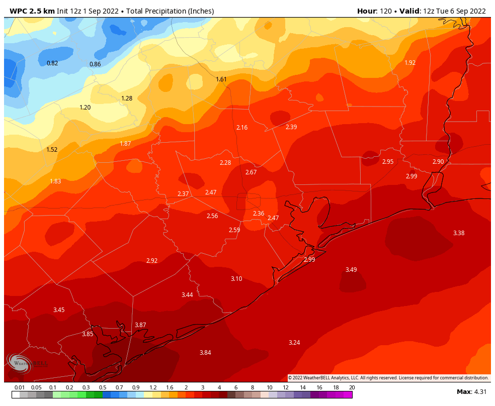
Well, you can’t say we didn’t warn you. For awhile now, we’ve been suggesting that Labor Day Weekend in Houston will be soggy, and we’re sticking to that story. Daily rain chances on Saturday, Sunday, and Monday will be upwards of 80 percent, with the potential for intermittent heavy rainfall as the aforementioned boundary stalls out over the region. Look for daily highs in the 80s, with nighttime temperatures in the 70s. Skies will be mostly cloudy. Overall, I think most of the area will see 2 to 4 inches of rainfall through Labor Day, but of course some isolated areas probably will see more. This should not be enough precipitation to cause significant flooding problems, but given the tropical air mass this is something we’ll be monitoring for you.
NOAA rainfall accumulation forecast for now through Monday. (Weather Bell)
Next week and beyond
Rain chances will remain elevated for much of next week, it looks like, and this should help to keep high temperatures in the upper 80s to possibly 90 degrees. There will probably be some periods when we see sunshine later next week, but it’s impossible to say when.
Now that we’re in September, we can start to realistically look for fall’s first cold that brings drier and cooler air into the region. There is nothing concrete in the forecast models, but there are hints at the possibility of such a front by around September 13 to 15. Right now I’d peg the chances of such a front actually making it at about 25 percent, but some hope is better than no hope I would say. Our first front typically comes during the second half of September.
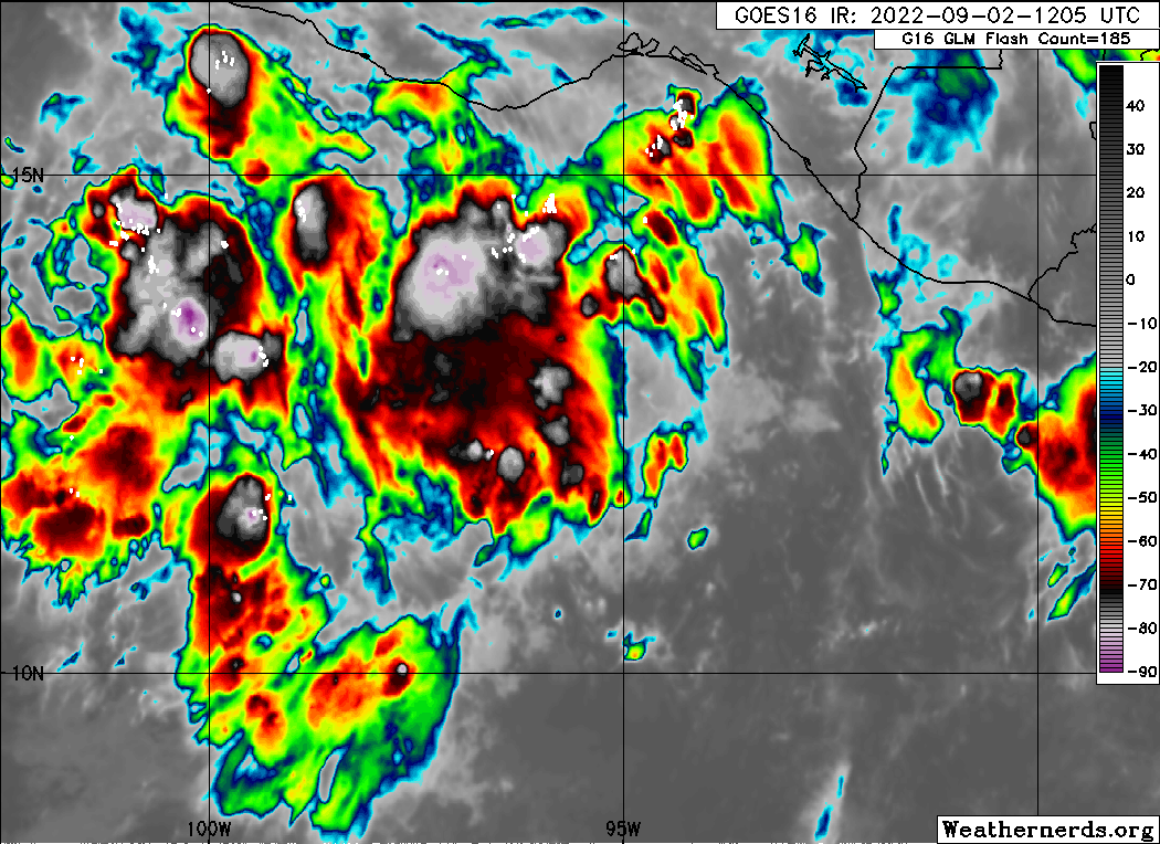
Tropical outlook for Thursday morning. (National Hurricane Center)
Tropics
After nearly two months of dormancy—the tropics have seen near historic levels of low activity through August this year—things are starting to pick up with a Tropical Depression in the central Atlantic Ocean and several other systems that could develop in the coming days. The very good news is that none of these systems appear likely to threaten the United States or Gulf of Mexico during the next week or 10 days, if not further. So this is a great place to be as we get very near the peak of the Atlantic hurricane season.