Houston dries out as we gain some clarity on holiday week weather

Yesterday didn’t disappoint from a forecast perspective. It pretty much went as expected. Rain totals ranged from around a half-inch to inch in Houston to around an inch and a half near the coast.
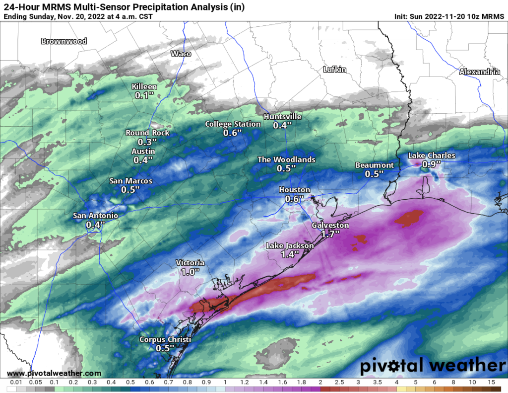
Estimated rainfall was highest south of Houston, with about a half-inch to inch across most of the metro area. (Pivotal Weather)

Your mileage may vary this morning, but the sun is out in force in my backyard, and it looks like many of us are enjoying a pleasant, albeit chilly morning! We will cling to this for a few hours before things begin to change. Again.

Fundraiser

We’re under 10 days left in our annual fundraiser, your one opportunity to directly support the site each year! The response has been amazing so far, and we are grateful to you all. You can click here to buy items. And if you don’t wish to purchase merchandise and just want make a contribution, click here and check the box that says “I’d like to make a donation only.” Thank you all so much!

Today and Monday

With many areas seeing sunshine this morning, it seems like it will be a nice front half of the day. As we go into the afternoon, clouds will begin to increase again. We are already seeing that creep into portions of Fort Bend, Wharton, and Brazoria Counties. Showers may begin to break out later today southwest of Houston. We should manage 50 to 55 or so this afternoon before temperatures are capped by increasing clouds. Areas southwest of Houston where clouds are already rolling in may not get above 50 degrees.

Rain will break out everywhere tonight. Periods of rain will be with us into much of Monday. The highest totals from this round may be north of Houston. That said, this rain looks as if it will be a little more sporadic in nature, so it may be truly “periods” of rain.
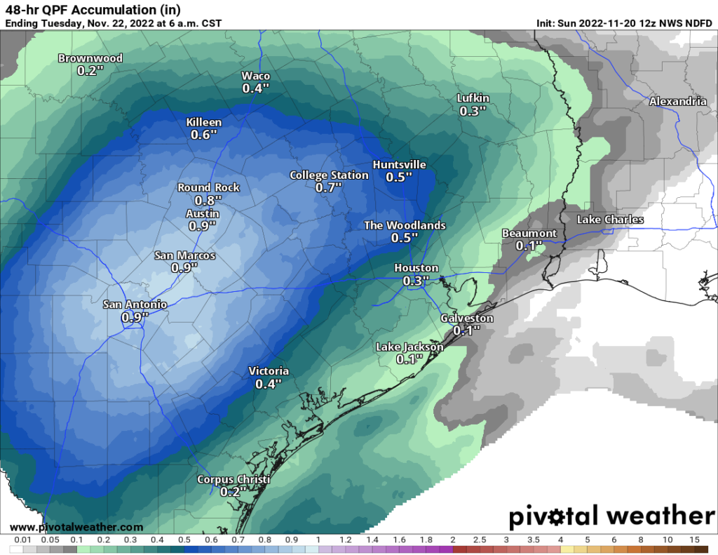
Rain totals tonight and Monday will average a half-inch or less in most spots. A few areas west of Houston may end up closer to three-quarters of an inch. (Pivotal Weather)

Rain showers should begin to taper off Monday evening and Tuesday morning.

Monday looks a lot like Saturday temperature-wise, with mid to upper-40s for most places at best.

Tuesday into the weekend

I think we’re beginning to get some decent clarity on this upcoming week. There are still questions about details regarding Thanksgiving itself, but our confidence is increasing for Wednesday and Friday.

Tuesday: Clouds, some sun, a shower possible. Morning lows 40s, daytime highs near 60.

Wednesday: Clouds, some sun, a passing shower possible. Morning lows upper-40s to near 50, daytime highs low or mid-60s.

Travel: We do not see any meaningful travel issues on Wednesday in Texas, Oklahoma, or Louisiana. Most major airport hubs look fine as well. Atlanta, Chicago, New York, DC, LA all look to be without major issues.

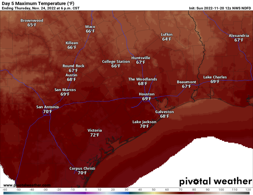
Thanksgiving Day: Clouds with a period of showers and storms possible. Exactly when & where is still TBD. Clearing late. Morning lows 50s, daytime highs upper-60s to near 70 degrees.

Thanksgiving Day looks warm — but not too warm. (Pivotal Weather)

Friday: Sunny! Breezy to windy, however. Morning lows 40s, daytime highs around 60 degrees.

Eric will have a full update on things for you Monday. Go Texans!

Rainy, raw Saturday with more coming Monday for Houston

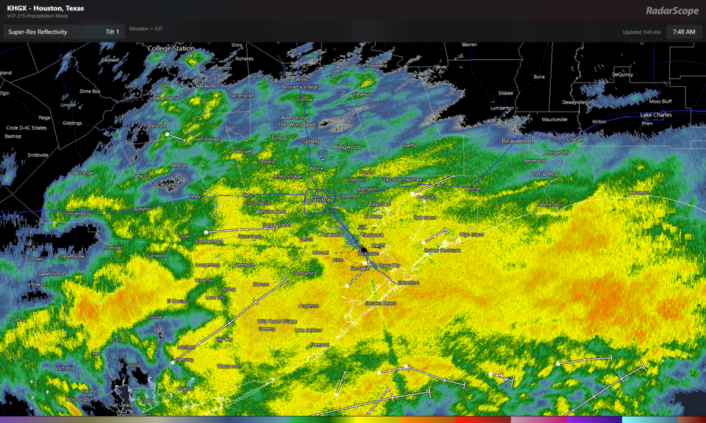
Good Saturday morning to you! You don’t need to be an expert on meteorology to look at the below radar image from 7:45 Saturday morning to know it’s probably going to be raining for awhile.

Rain is going to continue through most of Saturday, with gradual improvement overnight. (RadarScope)

Rain will be with us all day today. We should see the rain become more intermittent or taper off after sunset tonight, but it may not clear out a ton before Sunday morning.

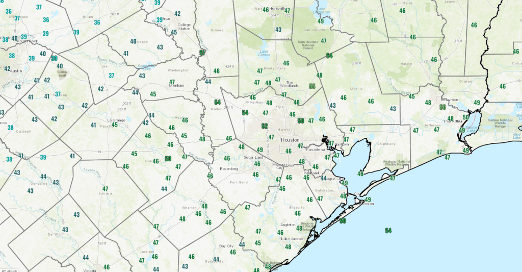
It’s in the 40s in most places in and around Houston this morning. Temperatures should refrain from budging much today, so expect the chill to remain.

Temperatures are mostly in the 40s this morning, and that is about as warm as they will get today. (NOAA)

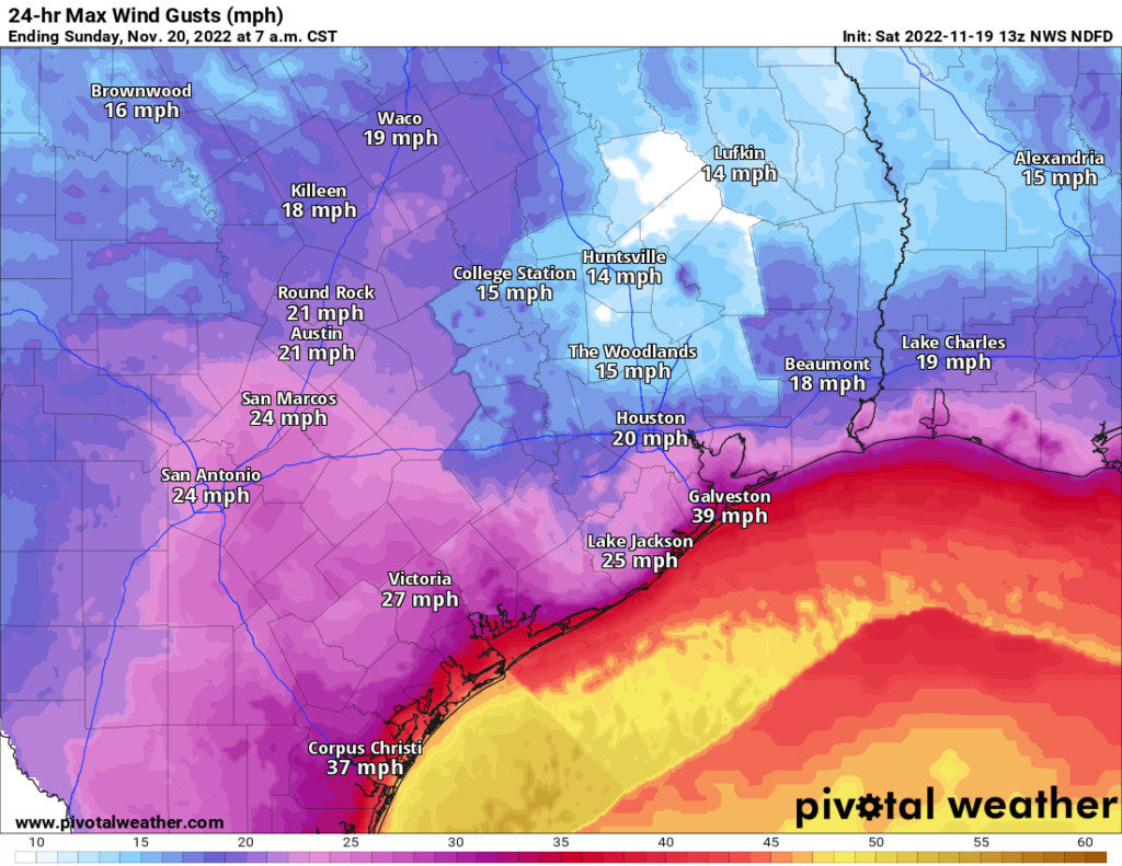
In addition to the rain and the chill, it will be breezy today. Inland areas will experience 15 to 25 mph wind gusts today. Areas along the Gulf or bays may even see some 30 to 40 mph wind gusts. Coastal locations have wind advisories, gale warnings (offshore), and small craft advisories (bays) all posted for today and tonight.

Winds will add to the chill today. Look for inland gusts of 15 to 25 mph at most. Coastal areas and bays will gust north of 30 mph, with 40 mph gusts possible on the Gulf and offshore. (Pivotal Weather)

All in all, just a Southeast Texas winter type day today.

Sunday & Monday

Any lingering light rain or showers should taper off before sunrise Sunday. If we are lucky, we’ll be able to sneak in a few hours of sunshine tomorrow before clouds thicken back up. Showers could begin to break out again south and west of Houston by mid-afternoon. Those will overspread the area Sunday night and Monday before tapering off Monday night. Some of this rain could be just a little heavier at times than what we see today. Temperatures will be in the low-50s on Sunday, 40s Sunday night, and probably struggling to get to 50 on Monday.

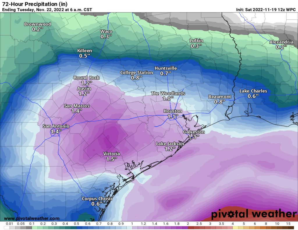
When all is said and done, between Saturday and Tuesday AM we all should see roughly three-quarters of an inch of rain, with some places seeing an inch to inch and a half. (Pivotal Weather)

The farther north of Houston you are, the more likely you end up closer to a half-inch of rain. The farther south of Houston, the closer to an inch or more between today’s rain and Monday’s rain.

Tuesday through Friday

Some good news today: It appears that rain chances may be a little lower on Thursday. They certainly won’t be zero, and it seems likely that we see at least a period of rain at some point Wednesday night through Thursday. But it may be in a narrow window. Here is our updated thinking today:

Tuesday: Clouds, some sun, a shower possible. Morning lows 40s, daytime highs near 60.

Wednesday: Clouds, some sun, a passing shower possible. Morning lows upper-40s to near 50, daytime highs low-60s. (A note that travel conditions on Wednesday look decent across most of Texas and Louisiana)

Thanksgiving Day: Clouds with a period of showers and storms possible. Clearing late. Morning lows 50s, daytime highs upper-60s to near 70 degrees.

Friday: Sunny! Breezy to windy, however. Morning lows 40s, daytime highs around 60 degrees.

Fundraiser

Another thank you to all who have contributed to our annual fundraiser! It continues. You can click here to buy items. And if you don’t wish to purchase merchandise and just want make a contribution, click here and check the box that says “I’d like to make a donation only.” We are grateful for your support. Thank you!

Clouds increase again today, heralding a dreary Saturday for Houston

An abnormally cool stretch of mid-November weather continues. We’ve already had more sub-60 degree days this week than all of last November and December combined. Of course, given how warm last year was, that isn’t saying much. But still. We have at least a few more days of sub-60 weather before things change somewhat.

Fundraiser

Thank you again to all who have contributed to our annual fundraiser! We are truly grateful, especially in what has been a pretty uneventful year (thank goodness). You can click here to buy items. And if you don’t wish to purchase merchandise and just want make a contribution, click here and check the box that says “I’d like to make a donation only.” Your support literally helps keep the site running, so thank you so much!

Today

Look for clouds to thicken up as the day progresses. We should begin to see sprinkles or light showers break out from southwest to northeast across the region. Initially, these may struggle to reach the ground due to dry air, but as we get closer to evening, I suspect we’ll get more reports of light rain or sprinkles. Temperatures should remain mired in the 50s today.

Saturday

Welp. Tomorrow may be a front-runner for most miserable day of the year.

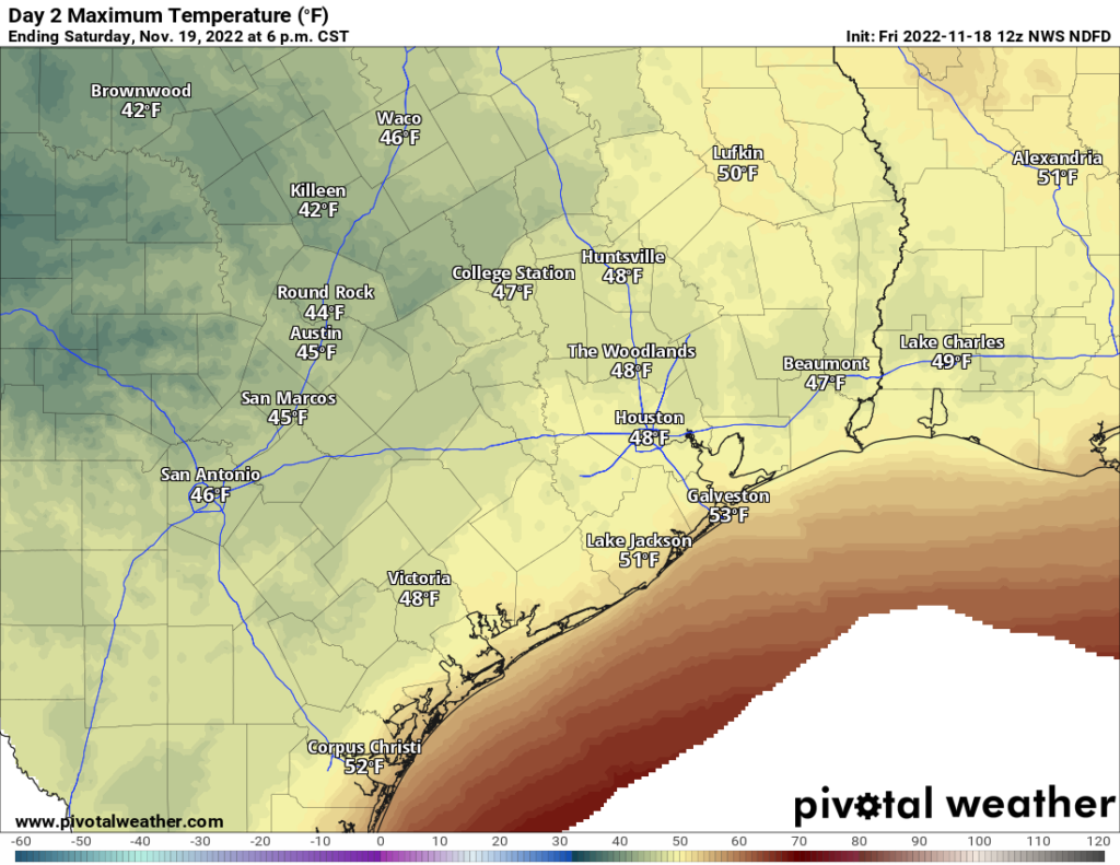
High temperatures are not expected to get past 50° on Saturday in most places. Along with that will be a stiff breeze, clouds, and periods of rain. (Pivotal Weather)

It’s a pretty simple forecast: Periods of rain, steady at times (especially south of Houston). Cloudy. Cold. Breezy. Temperatures will stay stuck in the 40s all day. Look for breezy conditions with winds of 15 to 25 mph at times, stronger over the water or near the coast. Just really raw, cold, and quite nasty for Houston.

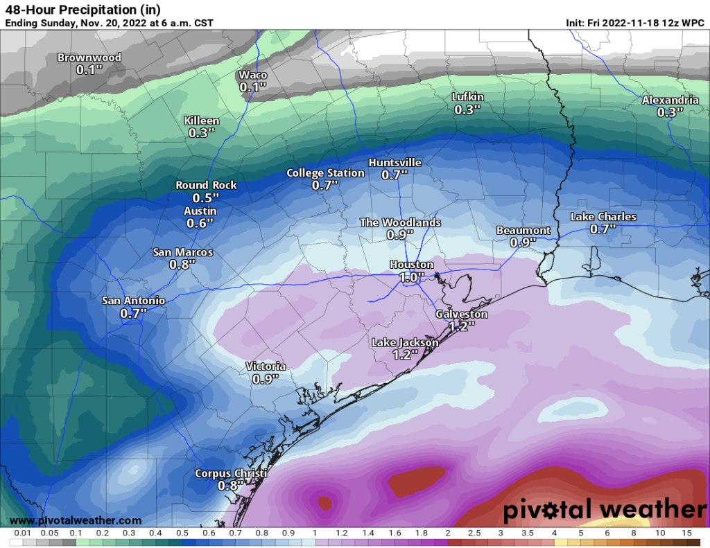
Rain totals will be highest south of Houston, but some meaningful rain may fall as north as Huntsville or College Station. (Pivotal Weather)

Rain totals will average a half-inch to inch and a half south of Highway-105. Some places may see a bit more, especially nearer to the coast. Others to the north may see a bit less. But everyone sees at least some rain tonight and tomorrow.

Rain should taper off from west to east overnight into very early Sunday morning.

Sunday

Despite Saturday’s gloom, I am optimistic that we should break out into at least a little sunshine on Sunday. It still won’t be a wonderful day, but compared to Saturday it will seem glorious. We should manage lower-50s. A few showers could break out late in the day west of Houston.

Monday

As of now, expect mainly cloudy skies on Monday with scattered showers or some rain. We’ll have to see if this trends more toward a wetter period like Saturday has done. For now, we’ll just call it scattered showers and update you this weekend. One thing we are confident it will be? Chilly. Again. Look for low-50s, maybe mid-50s if were lucky or upper-40s if we’re unlucky.

Tuesday and beyond

We continue to struggle with details regarding the Thanksgiving period. What we know is that there will likely be quiet weather on Tuesday with building rain chances Wednesday and Thursday. Temperatures should gradually sneak back above 60 degrees by Wednesday and Thursday, with morning lows in the 40s early, warming into the 50s and 60s late.

What we don’t know is exactly when it will rain Wednesday through Friday. Our modeling continues to struggle a lot with what may be a pretty significant storm across the Eastern U.S. One school of thought is for a slower moving, stronger storm that would bring thunderstorms and possible severe weather to Texas and Louisiana. That option seems to be fading some. Another slightly more likely possibility is for a quicker moving, weaker system with just a few showers and storms. Here’s the best thinking right now:

Tuesday: Clouds, some sun, a shower possible. Morning lows 40s, daytime highs near 60.

Wednesday: Clouds, some sun, a few showers or sprinkles, especially south and west. Morning lows 50s, daytime highs mid to upper-60s.

Thanksgiving Day: Clouds with a period of showers and storms possible. Morning lows 50s to 60s, daytime highs upper-60s.

Friday: Sun & clouds. Maybe a shower. Morning lows 50s or 40s, daytime highs low-60s.

That’s what we can give you for now. We will keep you posted this weekend with a daily morning update on the forecast both tomorrow and Sunday!

After some sunshine today, Houston will face a sustained stretch of gloomy weather

Good morning. Houston will continue to face winter-like weather through the weekend and into early next week. Of note: The forecast for Saturday looks particularly gloomy, with widespread showers, breezy conditions, and highs of perhaps only 50 degrees. We are increasingly confident that conditions will warm up next week ahead of the Thanksgiving holiday, but the details are rather messy.

Thursday

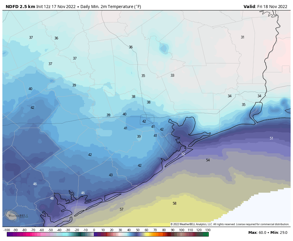
Temperatures are generally in the 40s this morning with leaden skies. Away from the coast, those clouds should thin out later today, leading to partly sunny skies this afternoon. Where conditions do clear, highs will push up to around 60 degrees, with light northeasterly winds. With partially clearing skies, low temperatures tonight will drop to around 40 degrees in Houston, with colder conditions inland.

Thursday night will be rather cold across the Houston metro area. (Weather Bell)

Friday

We may see some more sunshine on Friday morning before clouds start to build during the late morning or afternoon hours. In the big picture, high pressure will be moving off to the east, to be replaced by an incoming cold front that will arrive later on Saturday. I expect highs to reach the mid- to upper-50s for much of the area, with a slight chance of light rain during the afternoon hours, and a slightly better chance Friday evening. Lows Friday night will drop into the mid-40s in Houston.

Saturday

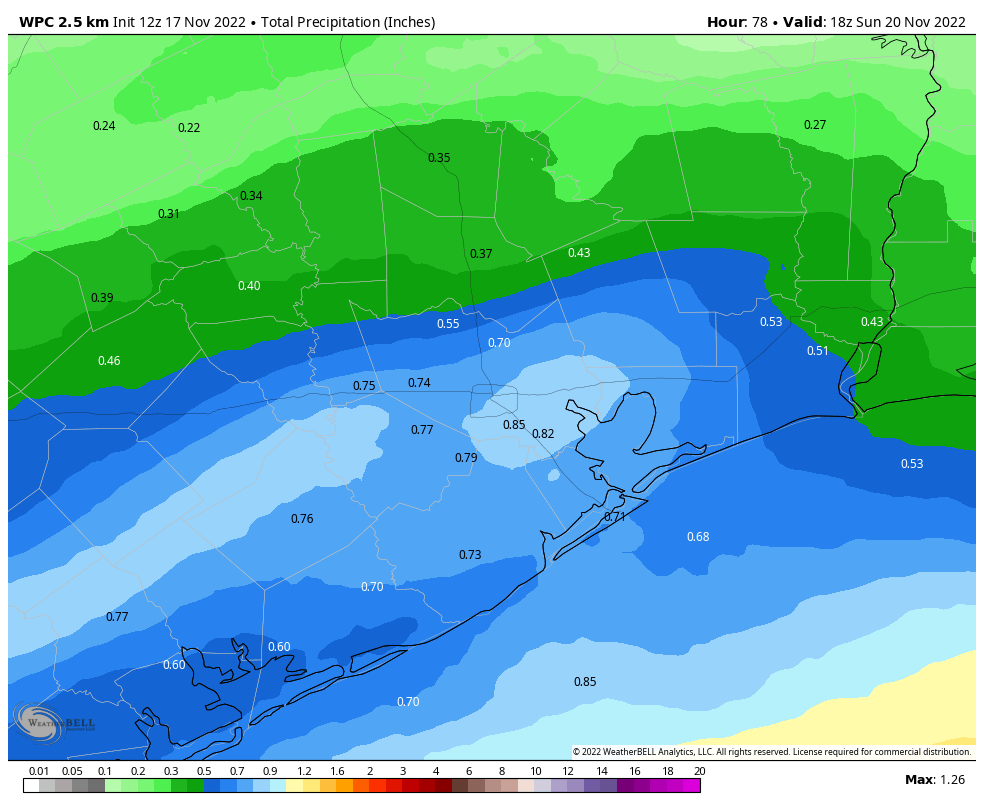
If you have outdoor plans on Saturday, I am sorry. As the front pushes into the Houston area it will combine with low pressure over the Gulf of Mexico to make for a wet, windy, and cold day. Highs on Saturday may struggle to reach 50 degrees for some locations, and we’re not going to see much, if any sunshine. Winds may gust up to 20 mph from the northeast, with even more blustery conditions along the coast. Most of the area will see between 0.5 and 1 inch of rain, with the bulk of it coming during the daytime on Saturday. Lows on Saturday night will drop into the low 40s.

NOAA rain accumulation forecast for now through Saturday night. (Weather Bell)

Sunday

The second half of the weekend looks slightly better, with only very slight rain chances. Still, expect mostly cloudy skies and highs only in the mid-50s. Winds will remain out of the northeast, albeit slightly less blowy than on Saturday.

Next week

Monday should be another cold, gray day with highs in the 50s. Some rain chances return, with perhaps of 40 percent likelihood of some light precipitation. After Monday it looks like the familiar onshore flow will finally return to the area, warming temperatures toward 70 degrees by midweek. As for Thanksgiving and beyond, it will all depend on the evolution of the next cold front and its associated storm system. There remains little clarity in the models on when that will move through, and whether it will bring any significant shower activity as far south as Houston. For now I’d lead toward a warmer, and possibly wetter Thanksgiving holiday. But that forecast remains about as firm as grandma’s Jell-O salad, which no one ever eats.

Fundraiser

We’re well into our annual fundraiser, when you can buy merchandise or donate money to support the work we do here (select “make a donation only”). Your contributions pay for keeping Space City Weather running even during the busiest times, fund further development of our app, and support the amount of time Matt and I devote to watching and writing about the weather. Thank you so much.