Rain chances ease back into Houston’s forecast this weekend

Happy Friday! We continue to see humidity running a little below average for this time of year in Houston, which may be <laughs mockingly> hard to believe, but it’s true! This weekend, we’ll see shower chances slowly re-enter the forecast, especially Sunday, as we heat up temps to 90 or a bit hotter.

In the tropics, yesterday started hurricane season and right on cue Tropical Depression 2 formed. It is not a concern for Texas and will just help to offer enhanced rainfall in Florida and Cuba. Read all about it on our new companion site, The Eyewall. Thanks to all who commented, liked, shared, and subscribed to our posts there. Keep spreading the word. We’ll be using The Eyewall to cover the entirety of the Atlantic basin just like we cover Houston here, a duty to which we remain fully committed!

Today

Look for sun, minimal rain chances, and temperatures around 90 degrees, give or take. We continue to battle air quality issues, and today is (again) an ozone action day, so please use caution if you’re in a sensitive group. We may see some improvement over the weekend. I don’t know that this is abnormal, but it sure has felt excessive since early May, something we know you’ve noticed.

A fairly typical early summer day awaits the Houston area, with very low-end rain chances Friday. (NWS Houston)

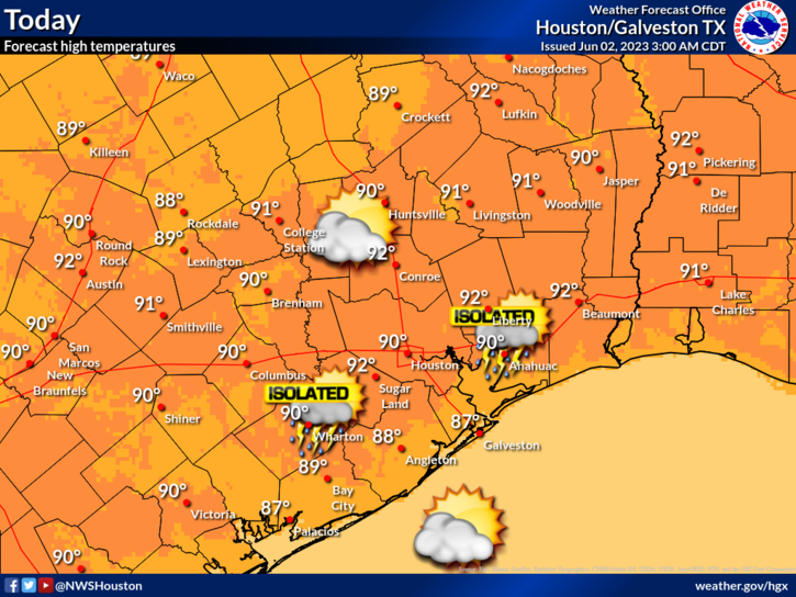
Rain chances are not zero, but they are rather low today. Still, you can never entirely rule out an isolated downpour in June.

Saturday

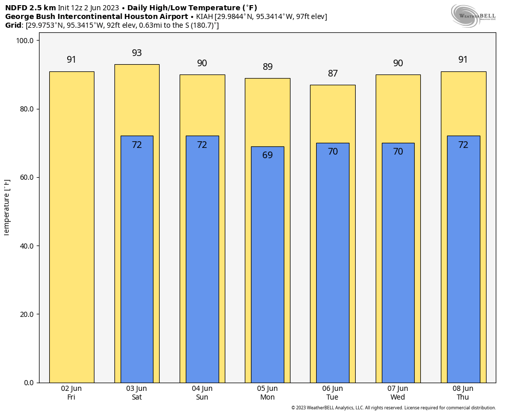
For the most part, Saturday should be a repeat of today. However, rain chances may be more like 10 to 15 percent versus the 10 percent or less that they are today. This may be especially true north of Houston. Expect morning lows in the upper-60s to low-70s, with a daytime high of 90 or better in most spots.

Sunday

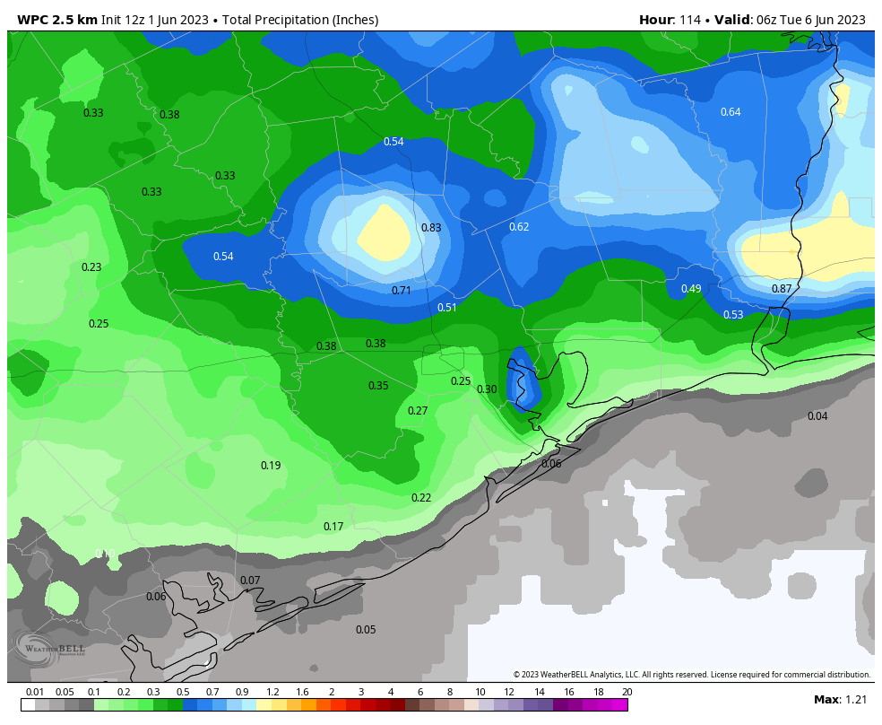
Rain chances bump up for Sunday late morning or afternoon. Look for sun, some clouds, and temperatures near 90, after a morning low near 70 degrees or a touch warmer. Isolated to scattered showers and storms are likely to fire through the day, with some areas seeing an inch or two of rain and others seeing nothing. Coverage should be somewhere at least in the 30 to 40 percent range.

Temperatures over the next week or so will reach their bottom with higher rain chances Monday and Tuesday before slowly creeping back up toward next weekend. (Weather Bell)

Next week

Look for additional isolated to scattered showers and storms on Monday and Tuesday. Things should gradually ease back to slight, hit or miss rain chances by later in the week. So your best odds of rain right now are Sunday through Tuesday. But even then, some of us may not see much, while others may get a few rounds of showers or storms. It will be an irregular pattern of rain. Look for temps to lull a bit early in the week due to clouds and showers, before warming back up later in the week. Rain chances should back off some after Tuesday or Wednesday, but we’ll see if that trend holds.

Hurricane season begins today, and we’re launching a website dedicated to tracking Atlantic storms

Good morning. Today marks the beginning of the Atlantic hurricane season, which will last for the next six months. It’s also a big day for Matt and myself, as we’re launching a new website devoted to tropical weather in the Atlantic Ocean, Gulf of Mexico, and Caribbean Sea. It’s called The Eyewall, and you can head over there now to check it out, and find out more information about what we’re doing. But I’m sure some readers will have questions about what this means for Space City Weather, and that’s what I’m going to address now.

Is Space City Weather going to change?

No.

Like not at all?

Like not at all. Matt and I are 100 percent committed to Space City Weather, and improving it every way we can. To that end, look for an updated version of our app soon, that squashes some bugs and delivers the much-asked for dark mode feature in addition to other goodies.

Why are you doing this?

There are two primary reasons. One, much of the current national hurricane coverage is sensationalized, and we think there is room for a different, no-hype approach. And two, we are frequently asked for local sites during hurricane season. (I.e. my mom is in Destin, where can she get this kind of coverage for Tropical Storm X or Hurricane Y) Well, now we’ve got an answer. We’re counting on you to tell friends and family beyond Texas.

Will there be cross-over between the two sites?

A little bit. The Eyewall will publish a “Daily Tropical Outlook” every weekday, and weekends as needed. There will be other hurricane content as well, and lots of coverage of active storms threatening land. Once a week we will cross-publish one of these “tropical outlooks” on Space City Weather (i.e. like with our weekly tropics report).

What happens if a hurricane threatens Texas?

For Space City Weather we cover the storm as usual. The local material would then be cross-posted onto The Eyewall. But our intent is that for readers of Space City Weather there will be no noticeable changes. We will not be publishing content from the Eyewall about storms affecting other parts of the country, or Mexico and the Caribbean Islands here, although we may link to it from time to time on Space City Weather.

Do you have a sponsor?

Not yet. Really, this is an experiment. Matt is taking on a big extra burden with this, and while we’re going to have some contributors, we want to see if this is sustainable. We also want to see if there are readers for this. Maybe it flops. Maybe it doesn’t. Really, we just want to give people some comfort in a terribly trying and traumatic time in their lives. We’ll see.

Now, onto the forecast…

Thursday

Our weather for the next few days will be guided by a modestly strong ridge of high pressure. This means we’re going to see warm and sunny weather. Highs today should reach about 90 degrees, with light southeast winds. One nice aspect of the weather is that dewpoints have not reached hair-melting levels yet, so the humidity won’t be oppressive. Lows tonight drop into the low 70s. Rain chances today are about 10 percent.

Friday

A little warmer, with highs in the low 90s. Otherwise, pretty much the same as Thursday.

Saturday

Another day with mostly sunny skies and highs in the low 90s. For areas far north of Houston, likely even north of Conroe, there is a slight chance of some rain showers later in the day.

NOAA rain accumulation forecast for now through Monday. (Weather Bell)

Sunday and Monday

As high pressure eases off, skies will become more cloudy in response to rising atmospheric moisture levels, and our rain chances will go up. Both Sunday and Monday should see about a 50 percent chance of rainfall, with accumulations in the order of 0.25 to 1 inch. Overall chances are probably a bit higher north of Interstate 10, but this far out I don’t have great confidence in that. The clouds should bring highs back down to around 90 degrees on both days.

Later next week

Rain chances continue for a few more days, helping to tamp down high temperatures. But it’s possible that we’re headed toward the low- or even mid-90s by later next week. Hello, June!