Plenty of sunshine in Houston’s forecast with an eclipse and big baseball series ahead

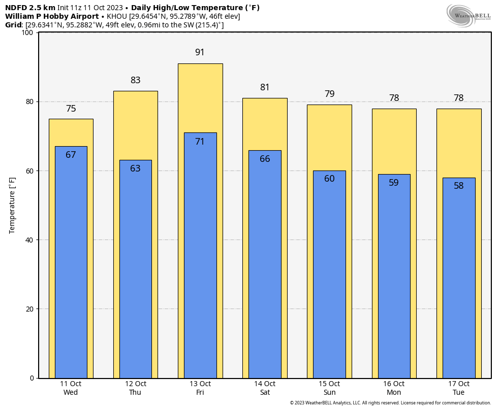
Good morning. After some rainier and cloudier days, Houston will now see lots of sunshine for the next week. Initially, that will lead to warmer conditions, but a cool front will bring us a very nice stretch of fall-like weather for the weekend and through the middle of next week.

The sunshine will be perfect for the annular eclipse on Saturday, which starts at 10:27 am local time, and reaches its maximum at 11:58 am when 90 percent of the Sun’s surface will be covered by the Moon. It will definitely be a little bit eerie out for midday, and your pets will probably be a little confused. Wings Over Houston should also see fine conditions.

NAM model forecast for cloud cover at noon on Saturday. Low numbers mean low cloud cover. (Weather Bell)

The weather also looks ideal for the opening games of the American League Championship Series, with the Astros hosting the Texas Rangers for games on Sunday and Monday. I am forecasting a 100 percent chance of early showers for the Rangers pitchers.

Thursday

After some drier and cooler weather on Wednesday, the flow over the region will turn more southeasterly today, which will bring warmer and more humid air into the region. Conditions today will remain fairly moderate, however, with highs generally in the low 80s with mostly sunny skies. Winds will be light at the surface, at perhaps 5 mph. Lows tonight will drop to around 70 degrees in Houston, with cooler conditions for outlying areas.

High temperature forecast for Friday afternoon. (Weather Bell)

Friday

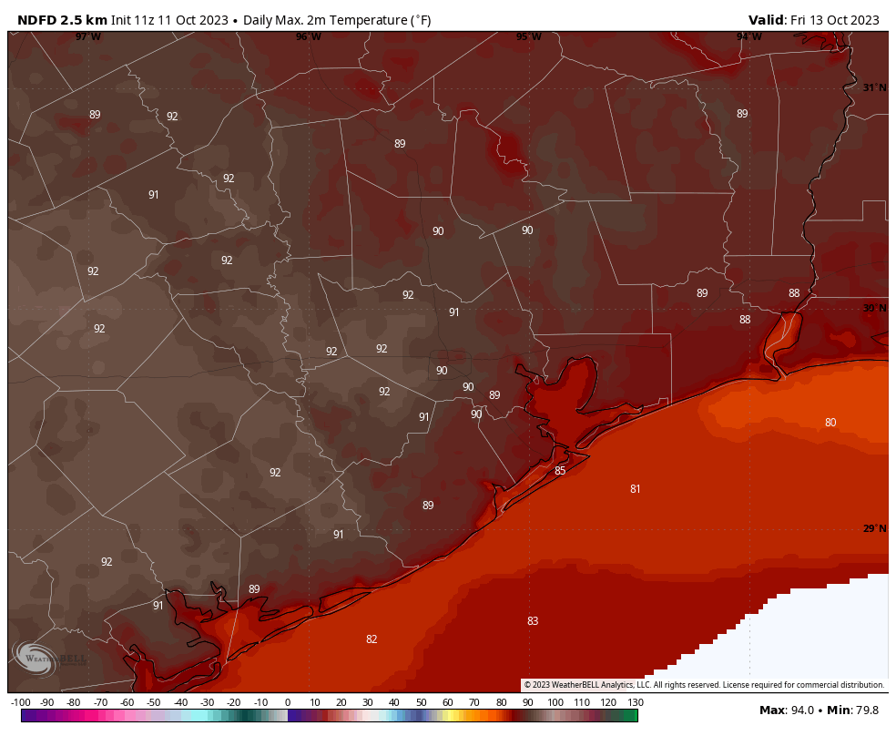
All of that warm air flowing into the region is going to help pump up temperatures on Friday. Much of the area is going to get into the upper 80s, and a few inland locations (at least) are likely to reach 90 degrees. I think there’s a decent chance this is the Houston metro area’s final 90-degree day of the year, but I cannot provide you with a guarantee of that. In any case, a front will arrive overnight to bring a substantial change.

Saturday

We’re starting to get a better handle on the timing of drier and cooler air. The front, with its northerly winds, will likely arrive in places like The Woodlands and Katy before midnight, push into central Houston shortly after midnight, and be off the coast by or before sunrise. The front’s passage will be heralded by northerly winds and a rapid influx of drier air. Rain chances are low to non-existent with the front. Most of the region will wake up to temperatures in the 60s on Saturday morning, with clearing skies. Look for highs around 80 degrees during the afternoon, with lows dropping into the upper 50s.

Sunday

This should be an awesome fall day, with highs in the low- to mid-70s and sunny skies. Lows on Sunday night should drop into the mid-50s.

Low temperature forecast for Tuesday, Oct. 17. (Weather Bell)

Next week

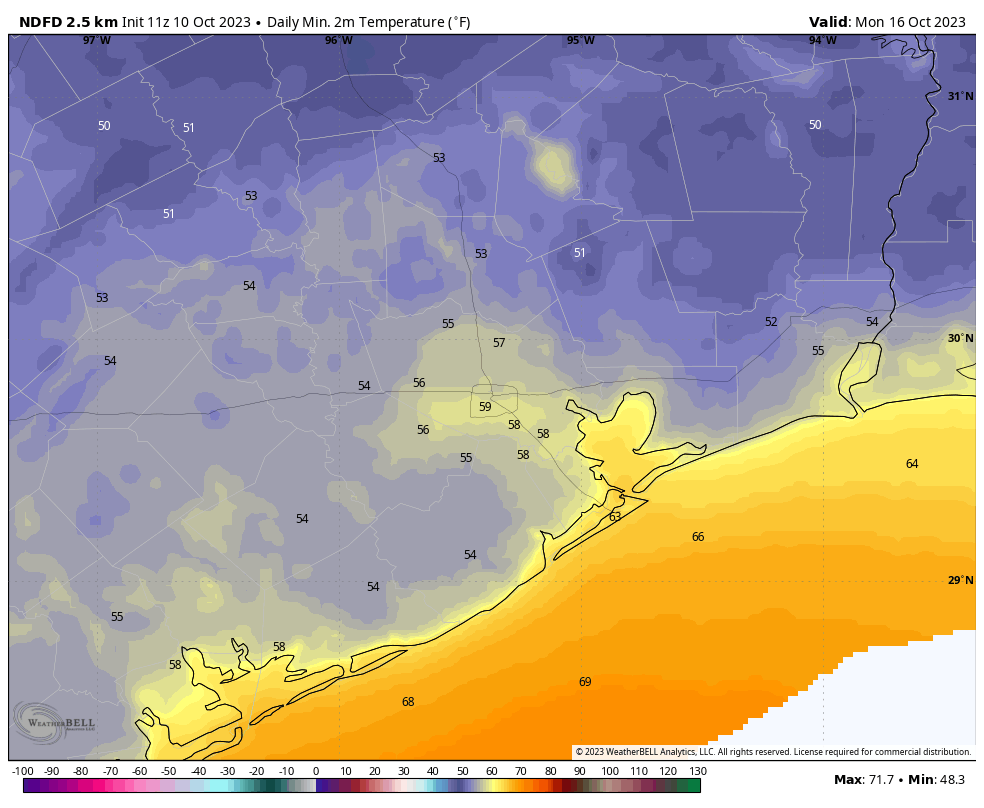
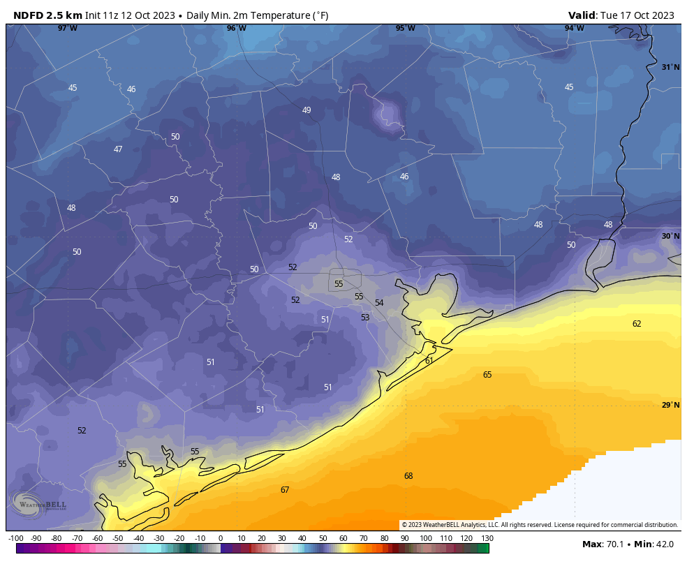
We’re going to see a continued northerly flow through the middle of next week which means that our cool and dry weather will continue. We may, in fact, not see our lowest temperatures until Tuesday morning of next week, when some inland areas may drop into the upper 40s. Rain chances and somewhat more humid air starts to return later on Wednesday or Thursday, but things don’t look to get super hot again. We’ll see.

Light to moderate rains today, followed by sunshine and eventually a good run of glorious fall weather

Good morning. Generally light rain is moving through the Houston region this morning in association with a low pressure system, and this should continue on-and-off through the morning hours. There are no flooding concerns. We’re still expecting temperatures to spike to around 90 degrees on Friday before a cool front cools us down for the weekend, bringing some wonderful fall-like weather into the area for awhile.

Wednesday

Skies will remain mostly cloudy today, even after the rainfall departs. This should help to limit high temperatures to the upper-70s for most locations. As mentioned above, the rain chances should end by around noon for most areas, with light easterly winds. A slightly drier air mass will move in behind the showers and this should allow temperatures to drop into the low 60s tonight.

Thursday

With partly to mostly sunny skies, we can expect high temperatures to reach the mid-80s on Thursday. Winds will be light, out of the southwest at 5 to 10 mph. Lows will only drop to around 70 degrees on Thursday night, however—so a bit sticky out.

Will Friday be our last 90-degree day of 2023? Quite possibly. (Weather Bell)

Friday

Atmospheric conditions on Friday will favor a fairly pronounced flow of warmer air from the south, and this in concert with sunny skies should allow high temperatures to reach 90 degrees. This return to summer-like weather will be brief, however, after the passage of a front later on Friday. Rain chances are near zero with the front. Areas such as The Woodlands should start to see drier air arrive before midnight on Friday, with coastal areas seeing an influx of northerly winds and drier air by or before sunrise on Saturday. This should actually feel like a front in terms of wind and drier air arriving all at once.

Saturday

When you wake up on Saturday, temperatures for most of the area will be in the low- to mid-60s, with northerly winds at 10 to 15 mph, and higher gusts. Expect mostly sunny to sunny skies for the annular eclipse, which will occur shortly before noon. Highs will reach about 80 degrees during the afternoon hours. Lows on Saturday night will drop into the upper 50s.

Hello, fall! (Weather Bell)

Sunday

A banger of a day, with sunny skies, generally light northerly winds, and highs in the upper 70s. Expect another cool-ish night, with lows in the upper-50s for most of the metro area.

Next week

A nice northwesterly flow will establish itself for the early part of next week, allowing the cooler and drier weather to prevail through Tuesday or even Wednesday. We’re talking highs in the 70s and lows in the 50s. The second half of next week could see the return of some rain showers and highs in the low 80s. We shall see.

After rain chances today and Wednesday, Friday may be our last chance to hit 90 degrees this year

I hope I don’t regret this prediction, but the writing is on the wall for the end of summer. After seeing our first significant front last weekend, another is on the way this weekend. Yes, it is still possible for the region to experience hot weather, but as the days get shorter the opportunities are more fleeting. It looks like we’ll have a decent shot to hit 90 degrees on this Friday. But after that? I don’t know. We might be done for 2023.

Climatologically it remains possible. The latest date in the calendar year that Houston has hit 90 degrees is October 29, back in 1991. Don’t get too excited, because the city has reached 89 degrees multiple times in November before. Anyway, it was a terribly long and hot summer in Houston. And now it finally appears to be over.

Tuesday

The story today is the potential for rain, with a tropical system in the Gulf of Mexico. The remnants of Hurricane Lidia (from the Pacific Ocean) have merged with a low pressure system in the Gulf. The National Hurricane Center gives this system a 30 percent chance of developing into a tropical depression or storm this week, and the seven-day outlook map below is a little concerning for Texas. But you needn’t be concerned. This is not September, it’s October, and there is a reason why we talk about September as a realistic end of the threat of hurricanes striking Texas. We can see that with this system, as the overall flow will pull it to the northeast this week.

Tropical outlook for Tuesday morning. (National Hurricane Center)

Texas is still going to see some rain from this tropical system, particularly coastal areas. South Texas might receive as much as 1 or 2 inches, but closer to Houston you’re unlikely to see much precipitation if you live north of Interstate 10, and perhaps 0.5 to 1 inch if you live closer to the coast. Mostly cloudy skies associated with the tropical system should help to keep a lid on temperatures for the middle of this week. Look for highs today of around 80 degrees, with light southerly winds. Lows tonight will drop into the upper 60s.

Wednesday

Another cloudy day with the potential for showers during the daytime. Look for highs in the mid-70s, with easterly winds. Rain chances slacken by Wednesday evening, with lows dropping into the mid-60s.

NOAA rain accumulation forecast for now through the weekend. (Pivotal Weather)

Thursday

Some slight rain chances will linger on Thursday, but with the tropical system pulling away we should see mostly sunny skies and highs in the low-80s. Lows on Thursday night will drop to around 70 degrees.

Friday

With sunny skies and a warm southerly flow, temperatures on Friday will have a chance to pop upward, toward 90 degrees, before the arrival of the next cold front. The front should arrive later in the day, with colder and drier air pushing all the way to the coast overnight into Saturday morning.

Saturday and Sunday

The weekend looks pretty glorious. We’ll see mostly if not completely sunny skies, with high temperatures likely in the upper 70s. The air will be plenty dry, with low humidity. Winds will be out of the north, generally at 10 to 15 mph, with gustier conditions on Saturday. So aside from the wind, it will be nigh on perfect.

By Monday we should see lows in the upper 50s for most of the area. (Weather Bell)

Next week

We’ll stay pleasantly fall-like through the early part of next week, with highs of around 80 degrees and fairly dry air. By the middle of the week we may see the return of some humidity and temperatures in the low- to mid-80s. And after that? Well, the crystal ball starts to get cloudy I’m afraid.

Autumn weather temporarily loosens up this week with a bump in rain chances south of Houston

Well, I sure hope you were able to get outside this weekend. For some people it was perfect weather, while others may have found it a little cool. Whatever the case, it was nice to step outside and not feel like my face was about to melt off. Surely, the next question some people have is whether or not this was just “faux fall,” and we see a return to a lengthy stretch of warm and humid weather again. The answer is not quite! More autumnal weather is on the way, and for some folks, more rain is on the way too.

Today

One thing that did surprise me a little this weekend was the resiliency of the high cirrus cloud deck. It certainly made for some nice skies, but it also diminished the sun a bit. We’ll likely see more of that today, especially south of I-10. North of I-10 should be basically fully sunny. It should be at least a little warmer overall, with highs in the low to mid-80s.

Tuesday

We’ll see a notable uptick in humidity here as onshore winds kick in, bringing in a relatively moist air mass. In addition, clouds will likely increase, and there should be at least some chance for a few mostly light showers, especially near the coast. Morning lows will generally be in the 60s, with highs in the low-80s.

Wednesday into Thursday

The forecast gets interesting here. Pacific-driven moisture courtesy of Tropical Storm Lidia and Tropical Storm Max will surge across Mexico and toward South Texas on Wednesday. This will all combine with a developing area of low pressure in the Bay of Campeche that will lift north and then quickly east across the Gulf. This should mean periods of rain or showers and a chance of thunderstorms. However, whether that’s in the Houston area or along the coast and offshore is still a bit fluid. North of I-10 should expect minimal rainfall. South of I-10 will see upward of a quarter-inch to perhaps as much as an inch near the coast. The heaviest rainfall is likely to occur from Matagorda Bay south to Corpus Christi and the Valley.

The rainfall forecast through Thursday morning might be a little optimistic overall, but locally, some areas, especially south of I-10 could see as much as 1 to 2 inches of rain. This forecast may change some between now and Wednesday. (Pivotal Weather)

Personally, I think the rainfall forecast above is a bit generous. I might shift the gradient 25 to 50 miles south based on the overnight model data. We’ll fine tune this tomorrow when we get a better idea of exactly how far north rain should get. Look for variable highs on Wednesday, with perhaps 80 or so north and 70s south depending on how much rain occurs. Wednesday may also have a bit of a breeze as well out of the east-southeast.

We’ll see gradual clearing Thursday, though there may be another chance of showers late in the day. High temps should be back in the mid-80s most places.

Friday

We’ll peak temperatures on Friday with a bit of drier air. It will be start very warm and humid with mid to morning lows in the 70s. The humidity may drop some during the day with offshore winds, but that will allow temperatures to warm well into the 80s.

The first push of slightly drier air will occur Friday, and we’ll see highs into the 80s. (Pivotal Weather)

Cooler air arrives Friday night into Saturday, ushering in another delightful fall air mass for the weekend. This front won’t have much moisture with it, so while a shower or two will be possible, most places will likely remain dry.

Weekend & annular solar eclipse

This weekend looks like a repeat with highs in the 70s, lows in the 50s, and low humidity. Just super nice autumn weather. For now, the cloud cover situation for Saturday’s annular solar eclipse looks great with most of Texas in the clear (the exception may be the Rio Grande Valley and Panhandle).

Simulated forecast satellite image for midday Saturday shows just a few clouds in the Valley and Panhandle with the rest of the state virtually in the clear for the annular eclipse. (Weathernerds.org)

I will say that I want to be a little cautious after this weekend’s more abundant high clouds, but at this point things look great. Fingers crossed. We’ll watch this closely through the week.