I hope I don’t regret this prediction, but the writing is on the wall for the end of summer. After seeing our first significant front last weekend, another is on the way this weekend. Yes, it is still possible for the region to experience hot weather, but as the days get shorter the opportunities are more fleeting. It looks like we’ll have a decent shot to hit 90 degrees on this Friday. But after that? I don’t know. We might be done for 2023.
Climatologically it remains possible. The latest date in the calendar year that Houston has hit 90 degrees is October 29, back in 1991. Don’t get too excited, because the city has reached 89 degrees multiple times in November before. Anyway, it was a terribly long and hot summer in Houston. And now it finally appears to be over.
Tuesday
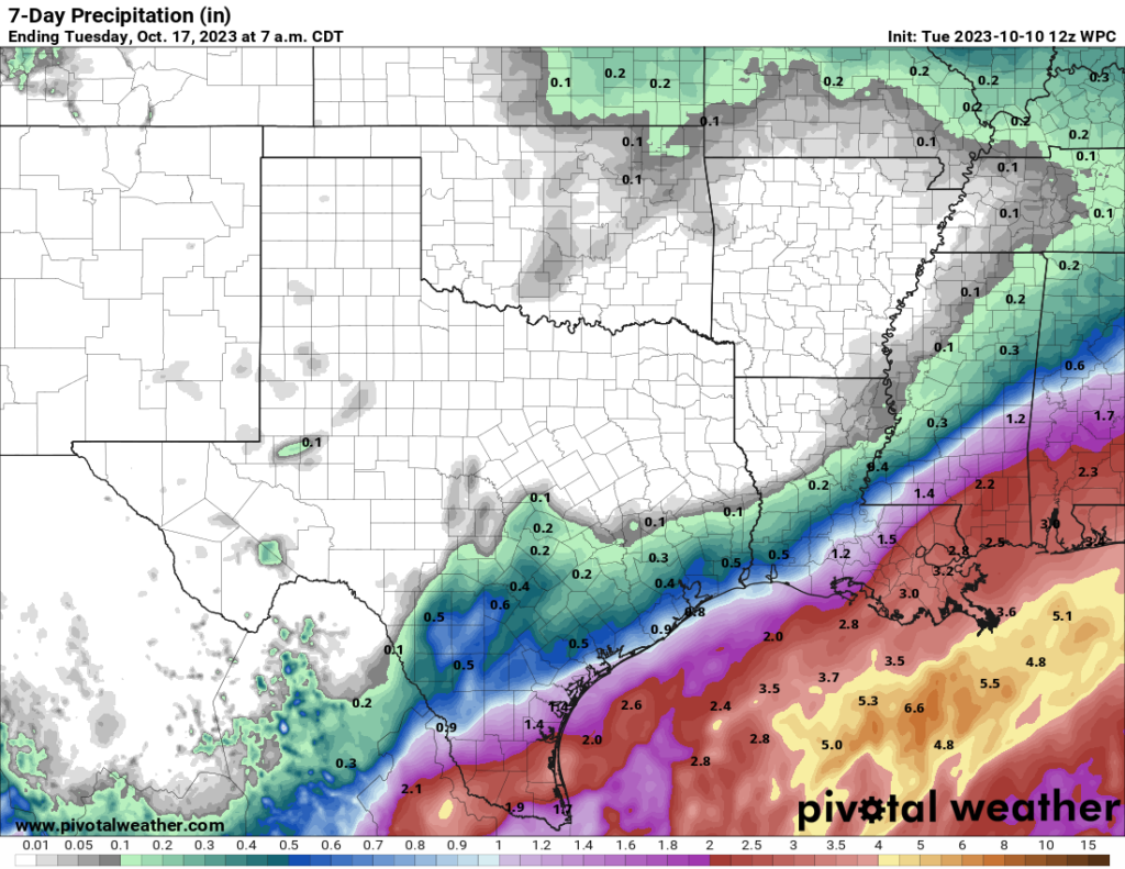
The story today is the potential for rain, with a tropical system in the Gulf of Mexico. The remnants of Hurricane Lidia (from the Pacific Ocean) have merged with a low pressure system in the Gulf. The National Hurricane Center gives this system a 30 percent chance of developing into a tropical depression or storm this week, and the seven-day outlook map below is a little concerning for Texas. But you needn’t be concerned. This is not September, it’s October, and there is a reason why we talk about September as a realistic end of the threat of hurricanes striking Texas. We can see that with this system, as the overall flow will pull it to the northeast this week.

Texas is still going to see some rain from this tropical system, particularly coastal areas. South Texas might receive as much as 1 or 2 inches, but closer to Houston you’re unlikely to see much precipitation if you live north of Interstate 10, and perhaps 0.5 to 1 inch if you live closer to the coast. Mostly cloudy skies associated with the tropical system should help to keep a lid on temperatures for the middle of this week. Look for highs today of around 80 degrees, with light southerly winds. Lows tonight will drop into the upper 60s.
Wednesday
Another cloudy day with the potential for showers during the daytime. Look for highs in the mid-70s, with easterly winds. Rain chances slacken by Wednesday evening, with lows dropping into the mid-60s.
Thursday
Some slight rain chances will linger on Thursday, but with the tropical system pulling away we should see mostly sunny skies and highs in the low-80s. Lows on Thursday night will drop to around 70 degrees.
Friday
With sunny skies and a warm southerly flow, temperatures on Friday will have a chance to pop upward, toward 90 degrees, before the arrival of the next cold front. The front should arrive later in the day, with colder and drier air pushing all the way to the coast overnight into Saturday morning.
Saturday and Sunday
The weekend looks pretty glorious. We’ll see mostly if not completely sunny skies, with high temperatures likely in the upper 70s. The air will be plenty dry, with low humidity. Winds will be out of the north, generally at 10 to 15 mph, with gustier conditions on Saturday. So aside from the wind, it will be nigh on perfect.
Next week
We’ll stay pleasantly fall-like through the early part of next week, with highs of around 80 degrees and fairly dry air. By the middle of the week we may see the return of some humidity and temperatures in the low- to mid-80s. And after that? Well, the crystal ball starts to get cloudy I’m afraid.


I am praying after this weekend the weather stays nice. It has been so beautiful and I have been loving it. God is so good, such a blessing after such a hot summer.
God also gave us a brutal summer. God is bad on that front.
What absurdity. We gave ourselves a brutal summer: First, our original sin brought evil into the world; second, our modern economy sent tons of CO2 into the atmosphere.
So if someone who prays for rain never gets it, is that Gods fault or Science?
“I’m so glad I live in a world where there are Octobers.” — Lucy Maud Montgomery, Ann of Green Gables
October is by far the best month in Houston. But the period from October 15th through November 15th is probably peak weather for our part of the world. It never stays great all that long this time of the year but typically we get a front every week or so to keep things pleasant. After that it can still be great but it can also be get grey and gloomy. So I will agree with Ann of Green Gables…
After 3 to 4 months of nothing but bright glaring sunshine, I’d be completely happy to see a long stretch of grey and gloomy!
🌬🍂🎃🍂🎃🍂
yeah
I’m grateful to live in a world with seasons! All kinds of weather have things to like about them (except maybe heat when there is no chance of rain!)
Great content here SCW, please keep it coming! Where can I buy SCW Swag?
When I read the headline about our “last chance” for 90 degrees, I thought: “Self, how about ‘no chance’ instead?”
Ninety degree days are so played out. Let us start the several months of “No Nineties”.
Nineties – great for music, not so much for weather.
It sounding like pretty amazing weather for Wings Over Houston this weekend
I recall one at least one Halloween when it was too hot for a costume when I was a kid. That would have been in the 70s.
You might be thinking of Halloween 1972. That was the warmest Halloween of the 1970s decade in Houston. At Bush Airport the high was 88 with a low of 76. That means it would have been unbearably warm and humid for costumes. In 1992 and 2004 we also had a hot muggy Halloween like that.
Joseph’s absolutely right. I remember running the A/C full blast that Halloween eve. As a matter of fact, that whole season from Sept through Dec was warm and then came January. After Dec of 72, we had three snows, one in Jan, one in Feb and one at the beginning of March.