This weekend may bring Houston’s final fling with proper winter weather

Summary: Houston will warm up for the next couple of days before a wet Friday is followed by colder weather this weekend. After we flirt with lows in the 30s on Sunday morning, however, temperatures will be on the upswing again. Does that mean the end of winter is at hand?

Is spring just ahead?

Just one week ago there was a lot of online chatter about another outbreak of the polar vortex bringing very cold weather to Houston. At the time we wrote about that a repeat of frigid weather was unlikely in Texas. Now, one week later we can definitively say it: Texas is not going to see another Arctic blast during the month of February.

In fact, after a flirtation with lows in the upper 30s this weekend, Houston may be done with very cold weather for this winter. Is that a guarantee? No. March can sometimes produce some winter surprises. But most likely we are about to move into a more spring-like pattern about one week from now. I’ll take a look at freeze possibilities for the rest of the season tomorrow, but they are fairly low at this point.

“An image capturing the dramatic scene of the Gulf of Mexico personified as a colossal water figure confronting a polar bear, rendered in the style of a 16th century Flemish painter.” (ChatGPT)

Wednesday

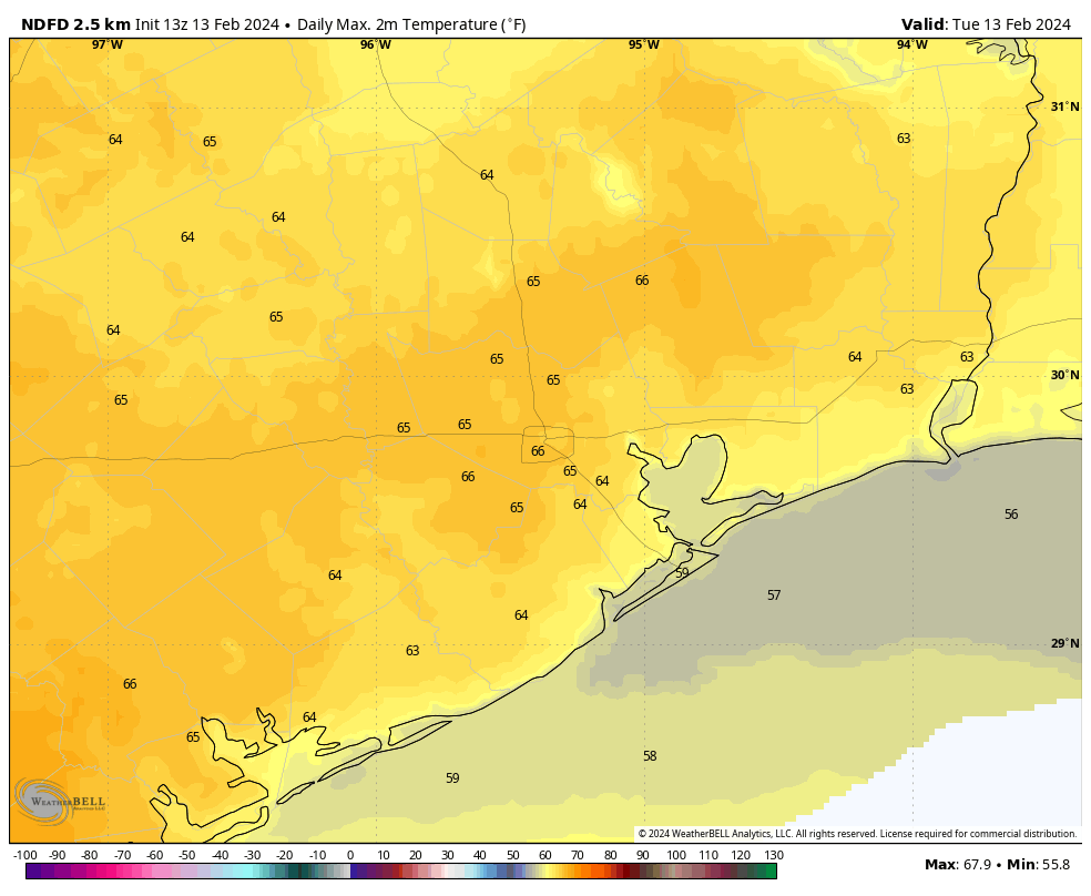
After a chilly start, conditions should warm nicely today, into the upper 60s. We should see mostly sunny skies through at least the morning hours before some clouds start to build this afternoon. Winds will be light, generally from the southeast. Lows tonight will be warmer under the influence of this southerly flow, and with clouds building in overnight. Expect temperatures to drop into the mid-50s in Houston.

Thursday

Skies will be clouded over on Thursday with light southeasterly winds. This will be a warmer and more humid day, with high temperatures in the mid-70s. Lows on Thursday night will drop to around 60 degrees.

Friday

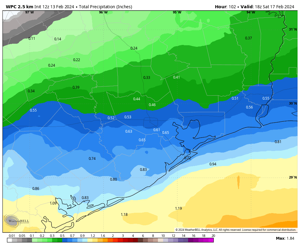
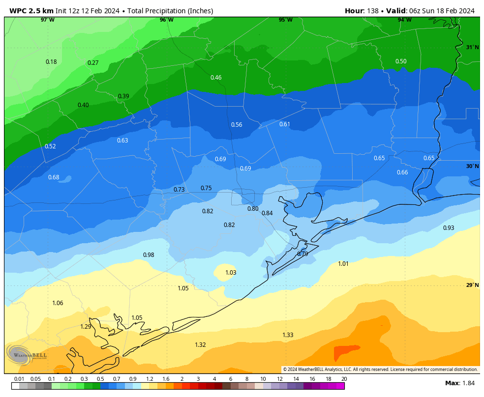
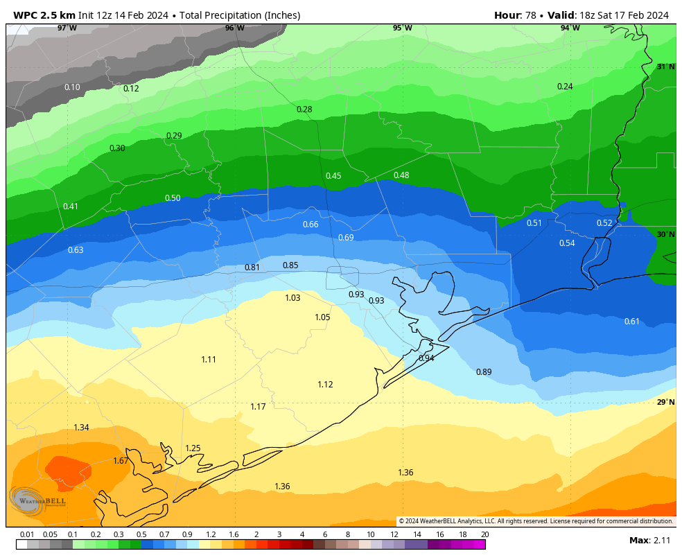
This still looks like the day for widespread showers due to the presence of a coastal low pressure system and plenty of atmospheric moisture. The greater accumulations will be near the coast, with 1 to 3 inches possible in places like Matagorda Bay, 0.5 to 2 inches in Galveston, and lesser amounts further north. Rain will be possible starting early Friday morning throughout the day, evening, and overnight hours. This shouldn’t be a flooding issue, but it could be a nuisance for outdoor activities. Highs will be in the 60s.

NOAA rain accumulation forecast for now through Saturday morning. (Weather Bell)

Saturday

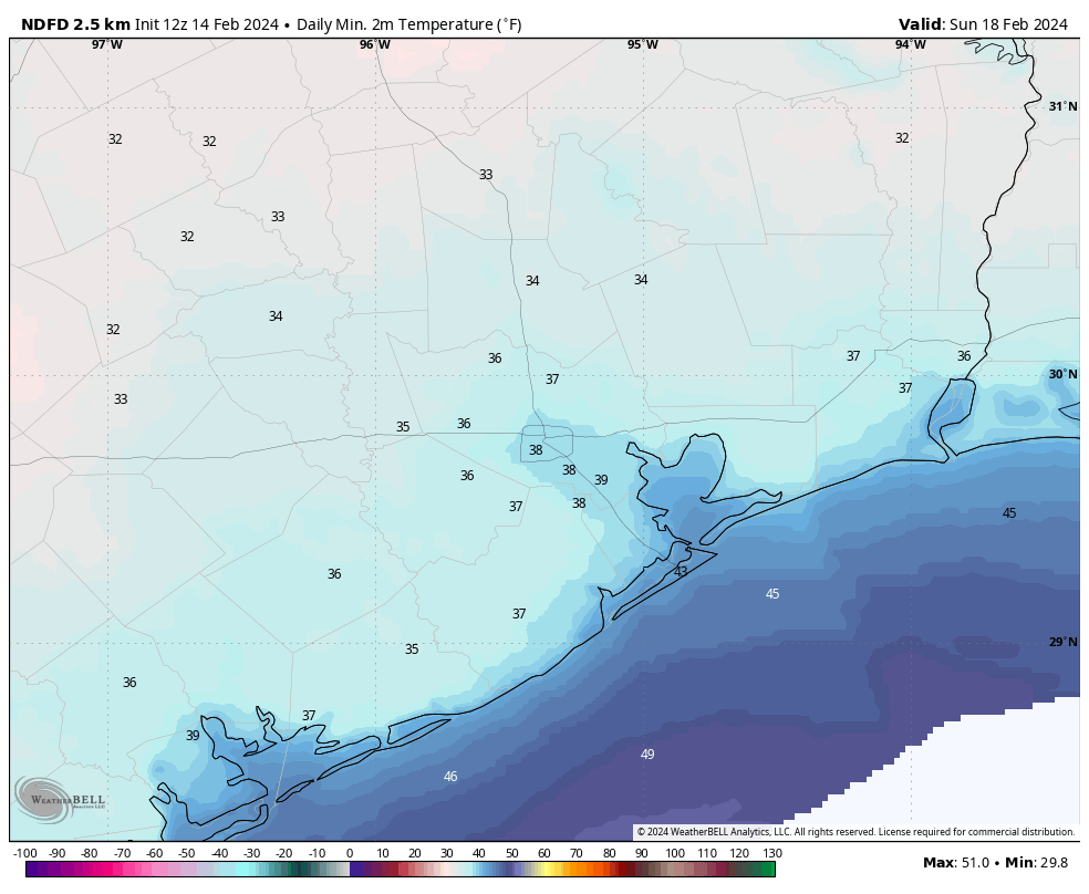
Saturday morning will be colder after a front blows in on Friday night, with cloudy skies and temperatures in the low 50s. It also looks quite breezy, with gusts above 30 mph. The good news is that any lingering showers should be ending as the Sun comes up or shortly after. By Saturday afternoon, with highs in the upper 50s, we could see partly sunny skies. Saturday night should be rather cold, with lows likely to drop to just below 40 degrees in Houston, and a bit colder further inland.

Low temperature forecast for Sunday morning. (Weather Bell)

Sunday

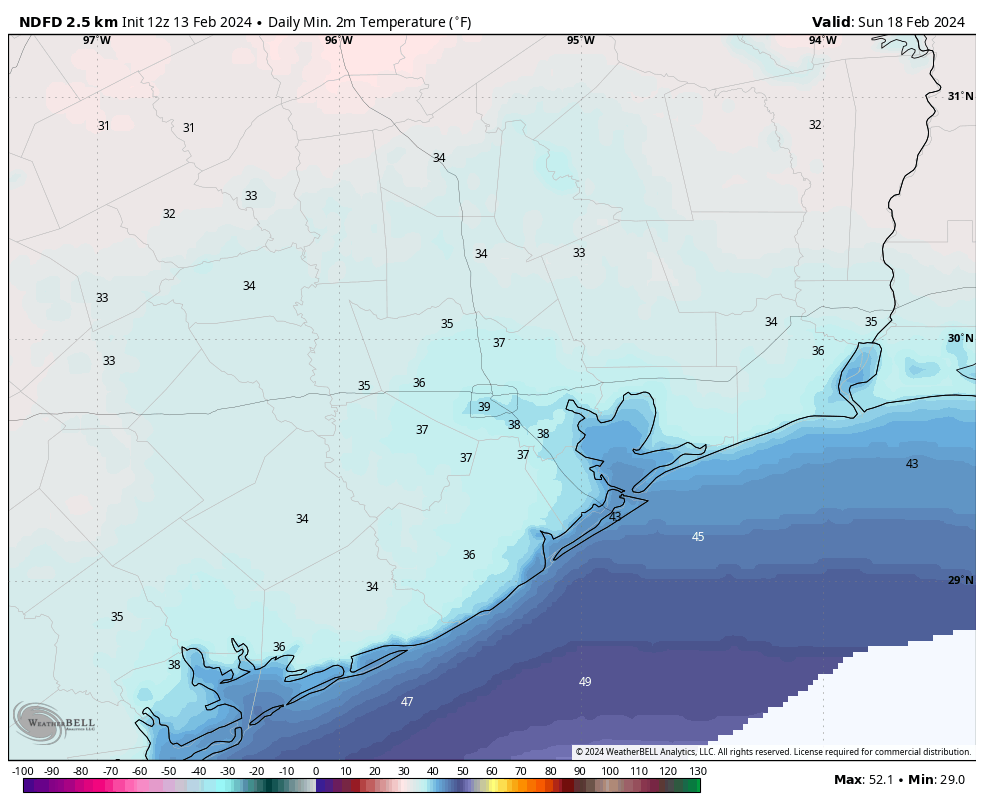
This will be a fine winter day, with sunny skies and highs around 60 degrees. Winds look light. This may be some of the last really dry air we see this season. Lows on Sunday night will drop into the low 40s in Houston, probably.

Next week

Most of next week looks warmer, with highs in the 70s and lows in the upper 50s to lower 60s. There should be a fair amount of sunshine and, as of this point, not a whole lot of potential for rainfall. As I mentioned, it will feel a lot like spring.

Houston’s weather today will be superlative as we transition to warmer days

Summary: Tuesday and Wednesday will bring some amazing weather to Houston before we cloud up and then see some showers on Friday. This weekend looks colder, with plenty of sunshine toward the second half. Next week should be mild.

We’re in that time of year when Houston’s weather swings from cold conditions to warmer and somewhat humid days, and then back again. It’s the in-between periods that I love most, those one or two days when we’re transitioning from the cold to the warm, when the sun is shining and the humidity not yet rebounded, that provides gorgeous weather. For this week today, and to a lesser extent Wednesday, are those days. If anyone can suggest a name for this terrific transition weather, I’d love to hear it.

High temperature forecast for today. (Weather Bell)

Tuesday

With high pressure holding sway, skies will be sunny today. After our chilly start (in the low 40s for most) we’ll warm nicely into the mid-60s. Today has it all: sunshine, very light winds, and low humidity. We’ll start to see a light southeasterly wind tonight that will herald the beginnings of an onshore flow, but temperatures should again drop into the low- to mid-40s.

Wednesday

Valentine’s Day will be pretty nice as well for you and your sweetheart, with partly sunny skies for much of the day and highs in the upper 60s. Winds will still be pretty light, but perhaps blow at 10 mph from the south. We’ll start to see more cloud cover later in the afternoon or evening hours. Lows will drop into the 50s.

Thursday

This will be a warmer and mostly cloudy day, with light southerly winds and highs generally in the mid-70s. With dewpoints near 60 degrees, the air will feel a bit more muggy than it’s been. Lows will only drop to around 60 degrees on Thursday night.

Friday

This day is likely to produce widespread showers, especially the closer one lives to the coast. First of all, that southerly flow is going to help pump up atmospheric moisture levels. The we’ve got a coastal low pressure system that is going to be a rainmaker. For now, however, it looks as though the majority of that precipitation is going to fall offshore.

NOAA rain accumulation forecast for now through Saturday morning. (Weather Bell)

Still, most of Houston south of Interstate 10 is likely to see 0.5 to 1 inch of rain between late Thursday night and Saturday morning. The most likely time for showers is Friday afternoon. Further inland you can probably expect 0.5 inch or less, with some spots possibly not seeing any rain at all. I don’t think we’ll see much in the way of severe weather at this point. Highs will be in the mid- to upper-60s.

Saturday

A front will blow in on Friday night, and this should bring an end to shower activity by Saturday morning. The day with start out mostly cloudy, but we may see some clearing of skies during the afternoon hours. Highs will likely top out in the upper 50s with some fairly gusty northerly winds during the daytime. With clearing skies overnight, temperatures may fall into the upper-30s in Houston, but I think a freeze will remain just north of the metro area.

Low temperature forecast for Saturday night. (Weather Bell)

Sunday

This will be a sunny, fine day with highs in the upper 50s to 60 degrees, with light winds. Lows on Sunday night will be a few degrees warmer than Saturday night.

Next week

At this point most of next week looks warmer, with highs in the 70s and lows in the upper 50s to lower 60s. Humidity levels will be up, but not oppressively so. Overall rain chances look low for much of the week.

Winter makes a blustery return to Houston, but temperatures will moderate by mid-week

Summary: After a warm weekend, winter has blown back into Houston overnight. We’ll be sunny and colder for a few days before a warming trend begins Wednesday. Showers and thunderstorms are likely on Friday and Friday night ahead of another front that should bring drier and cooler weather next weekend.

Monday

You’ll want a jacket this morning, with temperatures in the 40s across the metro area, and winds gusting up to 30 mph. Winds will remain gusty this morning, but should start to ease up later this afternoon and this evening. Skies will be sunny today, but with the influx of colder air highs will likely remain capped in the 50s. Tonight will bring the coldest temperatures of the week, with lows in the 30s for inland parts of the region, and 40s closer to the coast. With clear skies and light winds we’ll see ideal conditions for cooling.

Low temperature forecast for Monday morning. (Weather Bell)

Tuesday

After a chilly start, this will be a fine day with sunny skies, light winds, and temperatures in the mid-60s. Temperatures on Tuesday night will be a few degrees warmer, and as winds shift to come from the southeast, we’ll see the beginnings of an onshore flow overnight.

Wednesday

This will be another pleasant day, with temperatures in the mid- to upper 60s. I think skies will bring a mix of clouds and sunshine, with the likelihood of mostly cloudy skies by Wednesday evening. With a light southerly flow expect lows on Wednesday night to drop only into the 50s.

Thursday

Temperatures will push into the low 70s on Thursday, with mostly cloudy skies. It looks like rain chances will hold off until the overnight hours, at the earliest.

Friday

This should be the most dynamic weather day of the week. The combination of an increasingly moist atmosphere, low pressure over the Gulf, and an advancing front will pump up rain chances. In terms of accumulations, I expect most of the area to pick up between 0.5 and 1 inch of rain starting early Friday and running into Saturday morning. The closer to the coast you live live, the greater accumulations are likely to be. Highs, otherwise, will be in the upper 60s on Friday.

NOAA rain accumulation forecast for now through Saturday. (Weather Bell)

Saturday and Sunday

The aforementioned front will push into Houston during the overnight hours, and likely be off the coast by around sunrise on Saturday or shortly thereafter. Rain showers should end during the morning hours but clouds will linger. So expect a cool day, with highs perhaps around 60 degrees. Saturday night will be cold, with lows dropping to around 40 degrees in Houston, and with colder conditions for outlying areas likely. Sunday looks to be sunny, with highs around 60 degrees. Expect another chilly night.

Next week

I don’t have great confidence in conditions next week, but I’d bet on something like highs in the 70s, lows in the 50s, and partly sunny skies. After Friday’s rain chances things look dry for awhile.

Showers stymie Houston’s Saturday, with a proper soaking lurking not very far away

Summary: An area of heavy rain is expected to setup just northwest of Houston on Saturday, while the rest of the area sees mostly scattered showers. Exactly where this sets up will mean the difference between a washout and some nuisance showers. No serious flooding concerns are expected. Another wave of rain passes to our north on Sunday before cooler, drier weather builds in Monday. Most of next week looks quiet before we watch, sigh, more rain risk next weekend.

Today

Expect a mix of clouds and maybe a touch of sun today. Some coastal fog may drift in and out through the day, so if you’re down in Galveston be aware of that. Otherwise, much like yesterday a few showers should float across the area today, so you may encounter a brief downpour or two through the day. This seems likeliest north of Houston. Highs should again be in the mid-70s.

There will be a sharp gradient within the Houston metro area between a few inches of rain and less than an inch of rain, with the most likely area to see heavier rain just north and west of the city. (Pivotal Weather)

Saturday

Time to plan around another wet weekend. At this point it appears that showers will begin to break out just before sunrise south of Houston and lift northward through the city in the early daylight hours. By mid to late morning, we will be watching for basically a conga line of rain and thunderstorms to establish somewhere in the area along a stalled frontal boundary.

Admittedly, this is a little tricky. Stalled fronts can be a royal pain to try and pin down, but the best data we have at this point says that this line of rain and storms will predominantly focus north and west of downtown Houston. Where will that be? The axis from Sealy through Magnolia through Conroe through Lake Livingston is probably the most likely corridor to see this heavier rain. As of this moment. Could that shift south and east some? Absolutely. Could it shift further north and west away from the area? Absolutely. Under that axis it will be close to a washout. A few miles difference in location could change Saturday’s outcome for a few hundred thousand people. No biggie. So it’s a forecast to watch. But look for that to establish by late morning.

Outside of that somewhat narrow axis, there will be scattered showers or rumbles of thunder. But the day will not be a washout. Galveston for Mardi Gras? Mostly fine. Most areas south of Houston will just see a few passing showers.

The areas that see the mostly stationary line of rainfall will probably see on the order of 1 to 3 inches. Those outside of that will see varying amounts from a quarter to half-inch or so. Look for a sharp gradient between the have-lots and have-nots. Flooding should be mostly just ponding and the usual trouble spots seeing water. Still, be careful if you are driving north and west of Downtown on Saturday.

Aside from rainfall, Saturday should be a mild day with temperatures in the 60s under the rain and low-70s away from the dreariness.

Some stronger thunderstorms are possible later Saturday and into Sunday, primarily well north of Houston, where a slight risk (level 2/5) is in place for Huntsville, Lake Livingston, and Lufkin. (NOAA)

Sunday

Additional rain or showers will skirt the area on Sunday. Most of this is expected to remain to the north of the Houston metro, so think like College Station through Huntsville or out toward Lufkin. Some thunderstorms embedded in that rain could be strong, and a slight risk (level 2/5) for severe weather exists for Huntsville, Lake Livingston, and Lufkin. Amounts of rain should be more modest Sunday with perhaps up to an inch or so under the heaviest rain and a half-inch or less in most other places. It’s possible that Houston and points south of I-10 see little to nothing on Sunday. Most places should start in the 60s and get one final day in the 70s before next week’s cooler weather.

Monday

After several warmer days this week and weekend, Monday will be a bit of a stark change. We should see a good deal of sunshine Monday, but with a chilly, gusty northwest wind pulling down cooler air, we’ll only top off in the mid-50s after a morning in the 40s.

Tuesday through Thursday

Temperatures will bounce back into the 60s on Tuesday and perhaps upper 60s by Wednesday or Thursday. Morning lows will be in the 30s and 40s Tuesday, 40s Wednesday, and 50s Thursday. No meaningful weather is expected, and we’ll probably a mix of sun and clouds most days.

Beyond Thursday

At this point I think Friday will be quiet, but there is growing potential for another decent rainmaker next weekend. Yes, confidence in another wet weekend is increasing.

Our region has been highlighted by the Climate Prediction Center for potentially heavy rain next weekend. (NOAA)

When we’re forecasting this far out, particularly with respect to rainfall, we’re just looking for signals, not specifics. But the signal for next weekend has been consistent for the last few days in suggesting rain. We’ll see how that evolves over the next few days. But if you have plans next Saturday or Sunday, I invite you to lodge a formal protest with Eric. We’ll have more on those chances Monday.