Yep, it looks like Houston will get a good soaking this weekend

Summary: Houston is now solidly back in a warmer pattern, and this will eventually lead to some rain showers. The forecast for this weekend, in particular, is trending wetter. At this point I’d ballpark 1 to 3 inches of rain for most, but there is a risk for higher totals. We’ll be tracking it closely.

That colder air in West Texas is not going to push all the way to Houston until Sunday night. (Weather Bell)

Wednesday

The dry air was nice while it lasted, but now Houston will see much more humid air for the next few days. Eventually the increasing moisture levels in the atmosphere will produce some rainfall, but we’re not there yet. Instead, today will just be mostly cloudy with highs in the low-80s. Winds from the south will pick up from the south, at times gusting to 20 or 25 mph. In areas with lots of oak trees, we’re likely to see ‘pollen’ rain, in which tree pollen fills the air as if it were raindrops.

Rodeo forecast

Aside from the breezy conditions, the weather will otherwise be mild heading into the Houston Livestock Show & Rodeo this evening. Expect temperatures in the upper 70s with mostly cloudy skies. Temperatures will be just a few degrees cooler after the show, and overnight lows are not going to drop very far. Houston probably will bottom out at only about 70 degrees tonight.

Thursday

This will be a similar day to Wednesday, albeit with even stronger wind gusts. I think we’ll see gusts from the south at up to 30 or 35 mph. This strong southerly flow will be in response to a cold front that is moving into Central Texas. However, I don’t think we’ll see any storms Thursday due to a capping inversion that will prevent all of this warm air at the surface from rising too high in the atmosphere. In the unlikely event that the cap does break, we could see some thunderstorms. But probably not. Highs should again be in the low 80s with mostly cloudy skies. Thursday night will be warm again.

Friday

The aforementioned front is likely to move closer to the Houston metro area on Friday, but stall out to our northwest. This leads to some uncertainty in the forecast, but I think there’s a healthy chance of rain, perhaps 50 percent or higher, during the daytime. Accumulations are likely to be on the order of tenths of an inch, so nothing too significant, probably. Highs, otherwise, will be about 80 degrees.

Saturday and Sunday

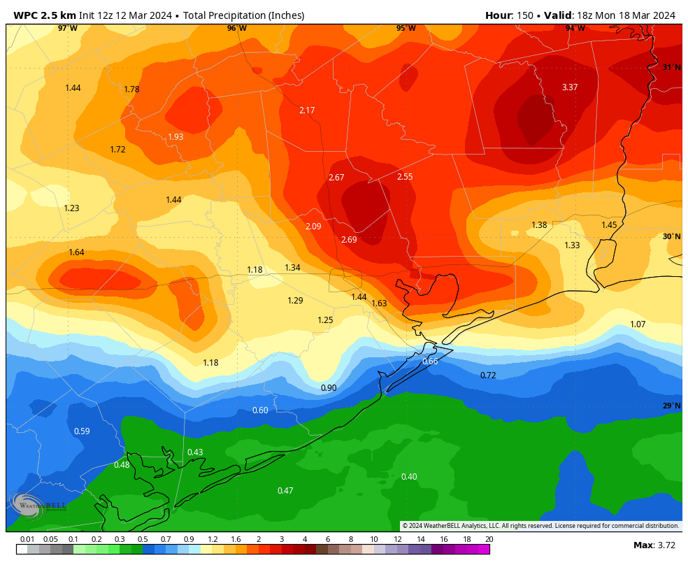
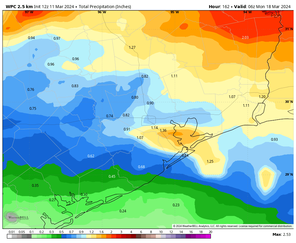
We’ve had some nice and sunny weekends of late. This will not be one of those. With plenty of moisture in place, and disturbances rotating through, the period of Saturday morning through Sunday afternoon looks rather wet. Most of the area is likely to pick up 1 to 3 inches, but there is a risk of higher end totals than this. Some models have been splashing accumulations of 4 or more inches, especially for areas along and north of Interstate 10. At this point I’m still not too concerned about flooding, but it’s something we’re going to keep a close eye on. In any case, if you have outdoor plans on Saturday or Saturday evening, bless your heart. They’re at risk due to showers and thunderstorms.

Houston’s forecast for the weekend is trending wetter. (Weather Bell)

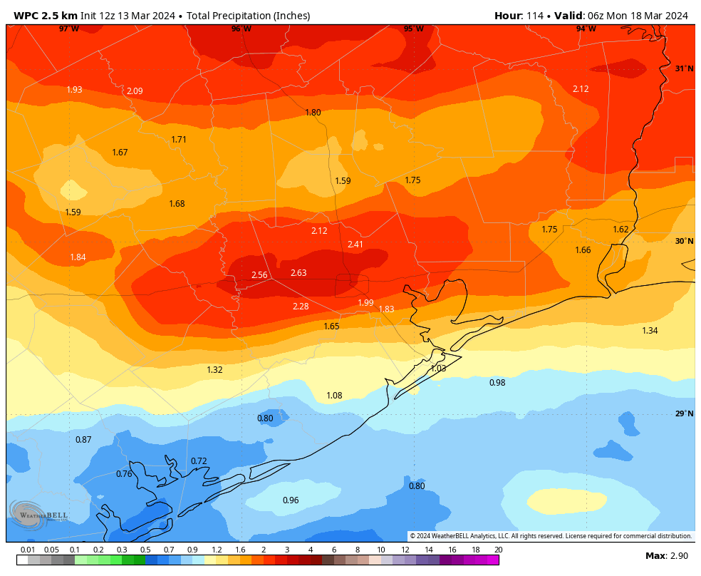
Highs this weekend will be in the 70s, with mostly cloudy skies. A front will finally shove all the way off the coast on Sunday, likely during the afternoon hours. This will bring an end to the rain and usher in some cooler and drier air. Lows on Sunday night will likely drop into the 50s.

Next week

Highs are likely to fall into the 60s with at least partly sunny skies by Monday and Tuesday, with lows in the 40s and 50s. There will be a nice slug of drier air for a few days, but the moisture will return by around Wednesday. This will set the stage for warmer weather and it looks like we’ll see some more rain by around Thursday-ish.

After a harsh summer and wet winter, Texas sees a brilliant bluebonnet season

Summary: In today’s post I discuss the bluebonnet season, and look ahead to warmer weather and a likely wet weekend. If you have outdoor plans, you’ll definitely want to keep tabs on the potential for precipitation.

Texas bluebonnets

I wanted to say a quick word about wildflowers in general, and bluebonnets in particular. If you’ve driven between Houston and Austin of late you know they’re spectacular. The combination of a very hot summer last year, which thinned out wildflower competition, and a relatively wet winter created near ideal conditions for this bluebonnet season. “On a scale from one to 10, this year looks like it could be an eight, for bluebonnets in particular, if not even better,” said Andrea DeLong-Amaya, of the Lady Bird Johnson Wildflower Center, in a forecast a few weeks ago.

A reader of Space City Weather, Niloeby Montenoeci, was kind enough to share a few photos taken of late. We are right about at peak season right now, so be sure and check these lovely flowers out.

Tuesday

It took awhile for skies to clear on Monday, but when they did conditions were lovely across the Houston metro area. Today will be a little more humid, a little warmer, and a little more cloudy. We can expect highs in the upper 70s this afternoon, with partly to mostly cloudy skies, and light southerly winds. This is the beginning of moisture return that should eventually set the stage for some healthy rain chances later this week.

Rodeo forecast

There should be nothing but fine weather for this evening’s show, with temperatures in the low 70s this evening and partly to mostly cloudy skies. Winds will be about 10 mph, so nothing crazy there. Afterwards conditions will be mild, with temperatures in the upper 60s. Lows tonight won’t fall much further, perhaps dropping only into the mid-60s overnight in Houston. Some fog may develop late tonight into Wednesday morning.

Wednesday

This will be a warmer day, with partly to mostly cloudy skies, and highs in the low 80s. Lows will only drop to around 70 degrees.

Thursday

A warm day, with highs in the mid-80s and fairly humid air. Some light rain showers are possible, but the overall chances are fairly low due to a capping inversion. If the cap breaks, we may see some thunderstorms later Thursday or into Friday ahead of a cool front.

Friday, Saturday, and Sunday

This initial front is likely to move into Houston and more or less stall near the coast. This means we’ll have a fair amount of moisture in the atmosphere and unstable conditions—a good starting point for rain showers. Daily chances are about 50 percent on Friday, Saturday, and Sunday, with total accumulations likely of 1 to 2 inches for most of the area. I don’t think this will be a total washout, but if you have plans for the weekend you’ll definitely want to keep tabs on the radar.

NOAA rain accumulation forecast for now through Sunday. (Weather Bell)

In terms of temperatures, we’ll see highs in the 80s on Friday, followed by 70s this weekend for the most part. A secondary push should shove the front offshore some time on Sunday or Sunday night, setting the stage for a cooler start to next week. Lows on Sunday night could drop into the 50s.

Next week

We should begin week in the 60s, with nighttime lows in the 40s or 50s, and some sunny weather. We’ll warm back up some by mid-week, when rain chances resume.

Houston should see some needed rainfall toward the end of this week

After a wet start to 2024, the Houston region has been largely rain-free for more than a month. Oh, there have been a few exceptions, with scattered shower here and there. But the spring greenery across the metro area has largely been coasting along due the rains received this winter. If you look closely at the ground, you might even see some cracking in the soil.

Houston rain and temperature plot for 2024. (NOAA)

I am not promising anything, but it does look like the Houston area will see two pretty healthy chances at rainfall this week, first during the Thursday and Friday period, and then again later this weekend as a front pushes through. While rainfall during the weekend is less than ideal, it would not be unwelcome to our burgeoning plants.

Monday

Today is my pick for the nicest day of the week. We’re seeing some very light showers along the coast due to a passing disturbance, but these will clear quickly this morning. After that we’re going to see a mostly sunny day with highs in the low 70s. Winds will be light, from the southeast, at 5 to 10 mph. With dewpoints in the 40s, the air will feel pleasantly dry.

Rodeo forecast

There are no concerns about attending the rodeo this evening, with temperatures in the upper 60s heading into the show and mostly clear skies. Winds will be light. After the bulls and the rock ‘n roll, conditions this evening will be mild. Temperatures will be about 60 degrees after the show, dropping into the mid-50s for most of Houston overnight.

Tuesday

This will be our last day with reasonably dry air, as the onshore flow continues. Look for highs in the upper 70s, with partly to mostly cloudy skies. Lows on Tuesday night will be warmer, dropping into the low- to mid-60s.

Wednesday

Our warming trend continues, with another partly to mostly cloudy day, and highs in the low 80s. Overnight temperatures are unlikely to drop much below 70 degrees, if any.

Thursday and Friday

This part of the forecast remains somewhat uncertain, but in the big picture it appears as though a front will move toward Houston and essentially stall. This will lead to a healthy chance of rainfall to end the work week, with mostly cloudy skies. I don’t anticipate any kind of a washout, but each day should have about a 40 to 50 percent chance of seeing showers. Highs will be around 80 degrees.

NOAA rain accumulation forecast for now through Sunday. (Weather Bell)

Saturday and Sunday

The pattern remains unsettled through the weekend. Temperatures are likely to be in the 70s, with healthy rain chances due to the stalled front and a fairly wet atmosphere. I think rain is a little more likely on Sunday than Saturday as a secondary front pushes through, but I don’t have much confidence in that prediction. All told, we’re likely to get something on the order of 0.5 to 1.5 inches of rain through the weekend. The second front, after moving off the coast, will probably push lows on Sunday night into the 50s.

Next week

Monday and Tuesday look a bit cooler, with highs in the 60s perhaps. After that we’ll see a general warming trend, at least into the 70s, if not the 80s.

Hit and miss showers for Friday followed by a much cooler, drier weekend

Summary: A couple rounds of shower chances exist today, this morning and later this afternoon. Many folks won’t see much meaningful rain though. Showers clear this evening with much cooler and drier weather for the weekend. Temps warm back up next week with rain chances returning for the second half of the week.

Before we begin today, Eric and I want to say “Howdy!” to Nyree Doucette’s 4th grade students at Sinclair Elementary. They have been using our forecasts to help plan for their Rodeo Day today, hoping for no rain. It’s been a real close call all week it seems, and unfortunately, it’s not any less close today as you’ll see below. Whatever happens, thank you for reading our forecast, hopefully you can learn something, and we really hope your Rodeo Day goes off and is fantastic!

Today

So, we saw a few more showers than perhaps we expected yesterday evening, which creates a slight conundrum in our forecast for today. Based on everything I’ve been able to digest this morning, I think there are two general phases to today’s rain chances. The first phase is this morning. Sorry to Ms. Doucette’s 4th graders.

The HRRR model depiction of how showers should progress today. Notice that not everyone sees them and the highest concentration is north and northeast of Houston. (Pivotal Weather)

That doesn’t mean the morning will be a total washout! But it does mean that we should see scattered showers around the region. I would not entirely rule out a rumble of thunder, but that should be the exception, not the rule this morning. Not everyone will see rain but those that do could briefly see some heavier downpours. I would assume the afternoon is partly sunny with some stray showers or a thunderstorm around. No severe weather is expected in Houston or points south at this time, but the chance for an isolated strong or severe storm increases as you go north of Harris County. Folks in the Piney Woods up through Shreveport may see some decent hailers today.

Severe weather risk today is mainly well north of Houston, with a slight risk (level 2/5) up toward Lake Livingston and Crockett. (NOAA SPC)

Other than that, highs today should manage our fifth consecutive day of 80 or better.

The second chance at some storms comes late this afternoon or this evening. Read on.

Rodeo Forecast

These storms should be even more isolated and less pronounced than anything earlier in the day, but one or two rogue thunderstorms could pop up in the area this evening with the actual cold front as you’re making your way to Houston Livestock Show & Rodeo. It’s Major Lazer night, so we don’t want to throw any cold water on your anticipation, but just don’t be shocked if there’s a brief 10 to 20 minute shower. Otherwise, the front should begin to push across the area in the evening, sending temperatures from to mid to upper-70s as you arrive to the upper 60s as you leave. There could be a bit of a breeze on the way out with noticeably lower humidity.

We’ll eventually see temperatures drop all the way into the mid-50s by Saturday morning.

Weekend

The weekend looks fine, albeit a bit on the cool side. Expect to see clouds giving way to some sun through the day Saturday and perhaps again on Sunday. Along with a breeze, temperatures will be in the mid-60s Saturday afternoon and the mid to upper-60s on Sunday with less wind.

Sunday morning should see lows in the 40s everywhere except the immediate coast. (Pivotal Weather)

Sunday morning will be a cool one, with lows generally in the 40s across the region!

Next week

Monday looks great with sunshine and highs back into the 70s. Morning lows should be near 50 degrees. Tuesday should see a few more clouds with morning lows in the 50s and highs in the middle or upper-70s.

By the time we get to Wednesday, a few showers will be possible, with a better chance Thursday and/or Friday. Details remain to be seen, but we still could be looking at some scattered downpours and thunder in that time. Highs will be in the 70s or 80s with some humidity and lows in the 60s.