In brief: Expect quiet weather this evening, but the Houston region is likely to see another round of showers and thunderstorms on Saturday, and possibly Sunday as well before high pressure takes control.
Good afternoon. The round of strong to severe thunderstorms that worked its way through Houston this morning has helped work over the atmosphere such that we’re seeing quiet conditions this afternoon. Due to this more stable atmosphere, we are likely to see continued fair weather this evening and into the overnight hours—which is good news if you have outdoor plans, graduation celebrations, or other activities.
The question becomes, then, what happens on Saturday?
Although Friday night into early Saturday morning will most likely be calm, that does not mean we’re done with storm chances. It looks as though we’ll see an additional round of showers and thunderstorms on Saturday. Some of these could become severe, but I anticipate they will be less severe than those on Friday morning, with the main threat being damaging winds, and possibly some slight chances for hail. In terms of timing, I expect these storms to flare up during the mid-morning hours in coastal counties before spreading inland. Heavy rainfall may briefly cause some street flooding. I’m hopeful we’ll see a reprieve in stormy weather on Saturday evening, and again during the overnight hours.
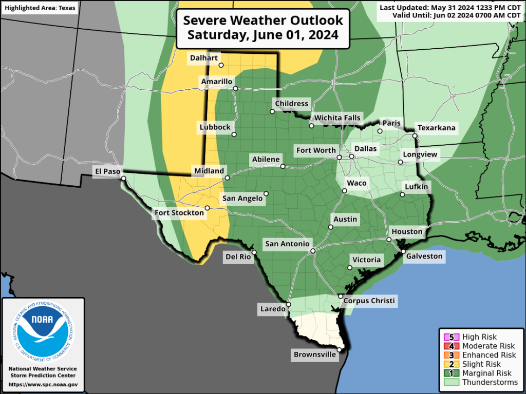
Severe storm outlook for Saturday. (NOAA)
As for Sunday, storm chances will diminish, but I’m not ready to write them off entirely as high pressure won’t really be in place yet. Another round of showers looks to be possible, but not overly likely, during the morning hours of Sunday. The rest of next week still looks mostly sunny, with highs in the low- to mid-90s.
We’ll have another update on Saturday morning to fine tune the storm forecast.
In brief: Strong to severe thunderstorms with gusty winds will push across the area through the morning. Street flooding and some scattered power outages are a good possibility. Additional storms are likely this weekend.
This morning
A squall line of strong to locally severe thunderstorms is moving into the area as we post this. Heavy rain, frequent lightning, localized street flooding, and wind gusts of 40 to 60 mph are a good bet as this pushes through.
Radar loop ending around 6:05 AM Friday shows strong to severe storms pressing into the Houston area. (RadarScope)
While these storms are not quite as severe as what we saw back on Tuesday this week, this will likely set the day off on the wrong foot. It wouldn’t be the worst idea to delay your morning commute until these pass. Most wind gusts have been 35 to 45 mph recently as these pass, which is relatively standard for strong storms here. Still, given the area’s sensitivity of late, some scattered power outages may occur in parts of the area.
This afternoon
The morning storms will clear off to the south and east. Since the timing of these storms clearing occurs in the morning hours, the atmosphere may not have enough time to recover this afternoon. While I wouldn’t rule out additional showers or thunderstorms in spots this afternoon, the worst of the action will hopefully be confined to the morning. After a rain-cooled morning, temperatures should recover into the 80s this afternoon. Eric will update later today on any changes.
Tonight & Saturday
Look for additional rounds of showers and thunderstorms tonight or Saturday. The exact timing and location remain frustrating to us in terms of predicting. But we are not done yet, that much we know. Some model guidance has a fair bit of storm activity tonight and Saturday, though mostly not severe and rain-focused. But this will be a period we continue to watch for storminess.
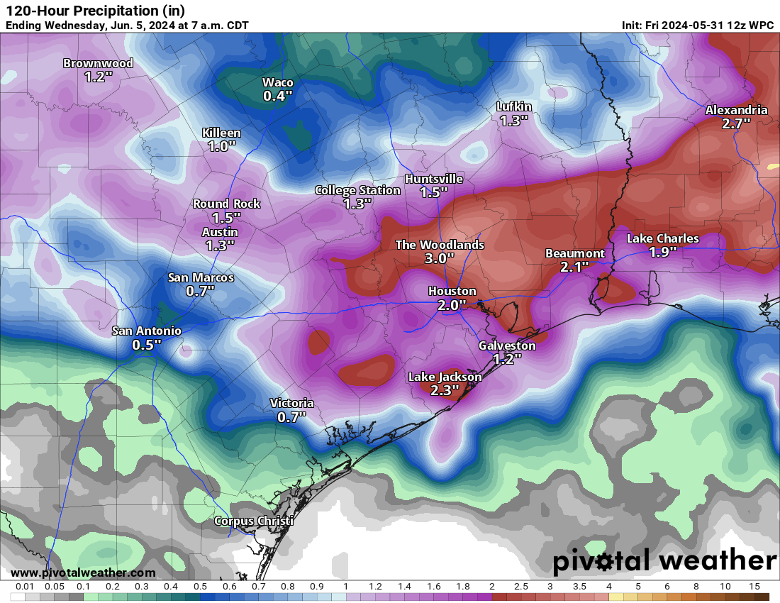
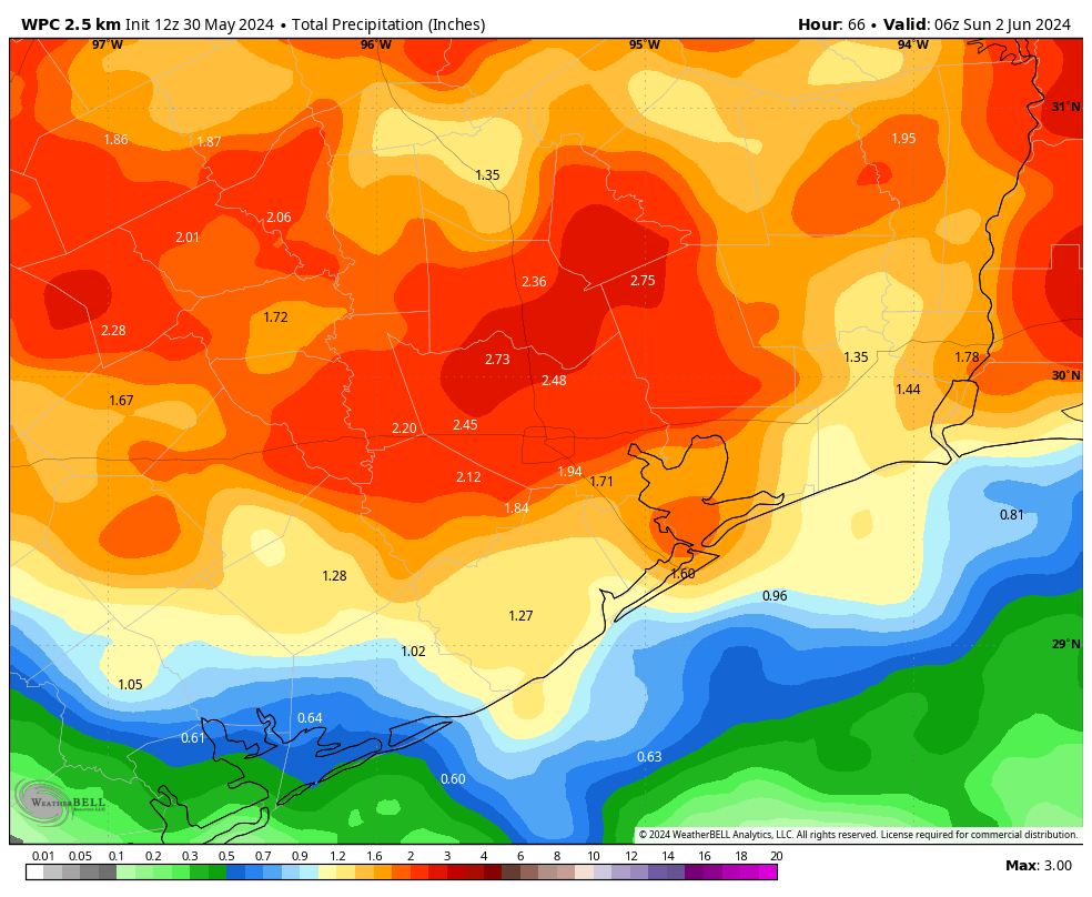
Expected rainfall over the next several days, including this morning will be in the 1 to 4 inch range. (Pivotal Weather)
Sunday
Support for thunderstorms should be about ready to exit starting Sunday. I still think there’s enough juice and disturbances left to fire off another round of storms around the area, along with heavy rain and perhaps gusty winds. But the hope is that these will become a little less frequent. Highs in the 80s to near 90 degrees, lows in the upper-70s.
Next week
Storms have tended to move around the periphery of a ridge of high pressure over Mexico that has provided them with absolutely punishing, extreme, record heat this month. As that ridge expands a little next week, we should see storms lift back to the north some each afternoon or evening. So favored areas will be north toward Huntsville or even north of there. We’ll see an uptick in temperatures with low-90s possibly shifting toward mid-90s by mid to late week.
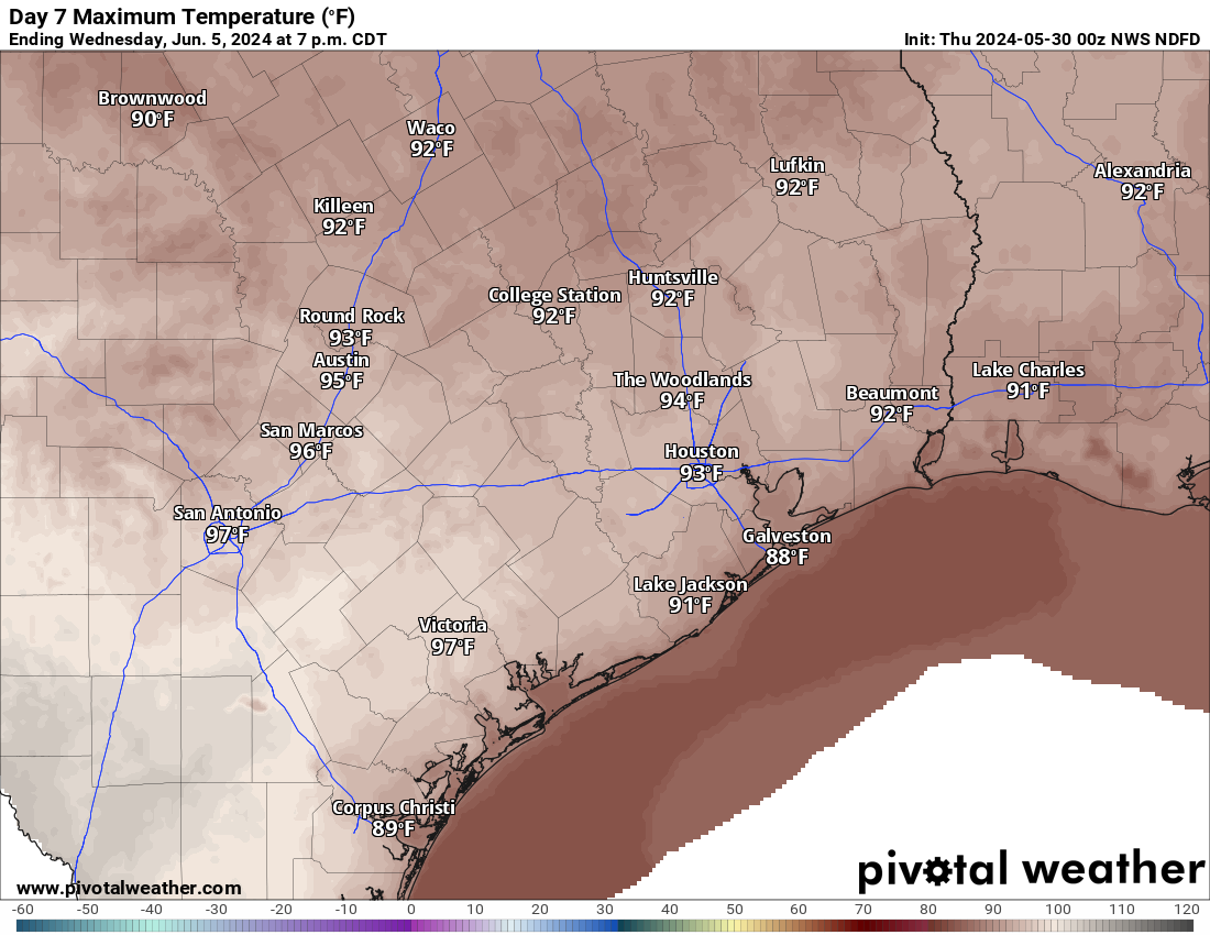
Wednesday’s high temperatures should be firmly back in the low to mid-90s. (Pivotal Weather)
The more noteworthy item for next week will be a disturbance or even some kind of cool front that arrives later in the week. If that happens and pushes off to our south and east as shown, there is the chance that we set the stage for much, much nicer, less humid weather for a couple days next weekend. I would not rule out a morning low in the 60s in the Houston area at this point next Friday or Saturday. It’ll still be plenty hot each afternoon, but the mornings may be refreshing. Maybe. We’ll see!
In brief: In the absence of high pressure, Houston’s atmosphere remains open to the passing of shortwave disturbances over the coming days. At this point Friday looks like it could see the most organized showers and thunderstorms, and the greatest chance of damaging winds, hail, and heavy rainfall. By Sunday storm chances start to wane, with next week looking warmer and mostly sunny.
Thursday
Skies will be partly sunny today, with high temperatures in the upper 80s. Like on Wednesday, this daytime heating should lead to the development of showers and thunderstorms during the period of 3 to 9 pm. Some of these could become severe. However, at this time I think chances are better along and north of Interstate 10, rather than closer to the coast. (Speaking of coastal areas, I wanted to shout-out the senior class of Clear Creek High School, where I’ve gotten to know a lot of great kids. Enjoy graduation this evening!) Lows tonight will be in the upper 70s.
Like on Wednesday, we’ll be monitoring the potential for storm development closely, and if the forecast for today or Friday changes significantly we will update the site accordingly this afternoon.
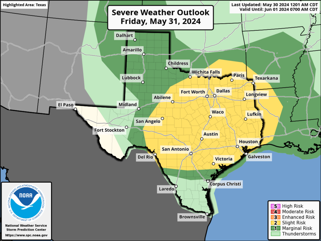
NOAA severe storm outlook for Friday. (NOAA)
Friday
At this point it looks like a more organized round of storms will move into the Houston area on Friday morning, likely sweeping into Houston around sunrise, give or take. This system will offer the best chance of severe weather, including damaging winds and hail. Depending on the severity of this system, there may be a second round of storms with daytime heating in the afternoon. (I.e. if the morning storms are weaker, there will be a better chance of a second round later in the day). Bottom line: If you need to be out and about tomorrow morning, be weather aware.
I would guess that most of Houston see an additional 1 to 2 inches of rain through Friday, but my concern is for higher bullseyes in stronger thunderstorms. At this point, Friday evening looks to see a break in showers. Daytime highs will be in the upper 80s.
Saturday
Our atmosphere will remain unsettled into the weekend, especially for Saturday. I don’t have much confidence in the details yet, but we could see another round of showers during the daytime on Saturday. These storms, at this point, do not look particularly severe. Highs, otherwise, should be around 90 degrees with partly sunny skies.
NOAA rain accumulation forecast for now through Saturday night. (Weather Bell)
Sunday
We may see some additional showers on Sunday morning, but I’m far from confident in that. Skies, otherwise, should be partly sunny with temperatures in the low 90s. If you have outdoor plans later in the day or evening on Sunday, I’d feel at least somewhat confident in them.
Next week
As high pressure settles in next week we’ll revert to mostly sunny skies and warmer temperatures. Highs should be pushing into the mid-90s toward the end of the week. Rain chances are low, probably close to zero. So it goes in summer under such a pressure system.
If it’s almost the end of the month, that means Eric and Matt have once again scrambled to answer your most urgent questions. And given the busy weather month we’ve had in May, this edition of our Q&A is particularly timely. Got your own queries? Hit the Feedback button in the blog’s sidebar, respond here with a comment on hit us up on our many, many social network feeds: X, Facebook, Instagram, Threads, Mastodon and Bluesky. We’re everywhere, and now that includes LinkedIn!
–Dwight
Q. I feel like y’all are being TOO underwhelming. I definitely get not overhyping the weather. Which is absolutely why I started following you. But the last three storms you’ve underhyped and I was not prepared. I’d rather be over prepared than under. I didn’t at all expect the insanity that Oak Forest got on [May 16]. Thank goodness my cousin texted me to take shelter minutes before the storm hit. Please consider a middle ground.
A. This isn’t a question. Next one, please.
Just kidding. It’s a fair comment. The reality is that just as we don’t ‘over-hype’ the weather we also try not to ‘under-hype’ the forecast. Matt and I really are trying to simply be as right as we can be. You mentioned under-hyping the last three storms. That’s not true. On May 13, we predicted significant hail could accompany strong thunderstorms as they moved through the Houston area. Some areas, we said, may see hail as “large as an apple.” In reality, no one saw much, if any hail that day. I realize that pointing out how we missed on another forecast is perhaps not the best defense of our record. But my point is that we do not actively seek to under-hype storms. We are striving, always, for the middle ground you espouse. Some days, however, it’s damn hard to find.
I’m also sorry you felt unprepared for the derecho that slammed Oak Forest and other parts of Houston. We wrote about that recently, and some of the learnings we are taking away from it.
–Eric
Q: During the recent extraordinary Houston area (and beyond) weather phenomenon, is there any consideration that “microbursts” were present?
A: Yes, in our post about derechos, we noted that basically, they’re gigantic bursts of straight-line winds. In a sense, you could probably refer to a derecho event almost like a macroburst, which is wind damage on a scale greater than two and a half miles long. In reality, within this complex storm, there were probably a mix of macrobursts and smaller-scale microbursts, in addition to a couple tornadoes. We did not exactly see uniform damage across the area, but clearly some neighborhoods were harder hit than others. The more meaningful answer is that it’s all semantics in a situation like that, and the widespread damage is damage.
–Matt
Q. This storm has sobered us for what we are in for this hurricane season. How do you prepare? What do we need to keep in stock? What food should we store up?
A. Whoa, hurricane season officially starts Saturday! Fortunately, it doesn’t look like things will be insane right out of the gate. But there’s no doubt it’s going to be a busy season. The most important thing you can do right now is understand your vulnerabilities. Is your home at risk of storm surge because you live near the coast, and at a low elevation? Are you at risk of inland flooding? Is your home built to withstand hurricane-force winds, i.e. does your roof have hurricane clips? Are you willing to go without electricity for a week or three in September? All of these questions are important to determine in what circumstances you would evacuate. And after you understand when you would evacuate, you should make a plan for where you would go, what you would take, and how you will get there.
Q: Is there any connection between the kind of intense spring weather we’ve been having and how hot the summer will be? Or are we most apt to have a drought when spring weather is severe?
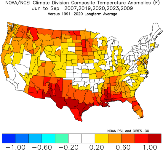
A: The simple answer is not really. If you look at enough meteorological variables, you can find loose correlations among a lot of things. But correlation does not always (or often) mean causation. The best proxy to an “intense” spring may be storm reports in Harris County. If I take the five busiest years prior to this one from March through May, I can find 2007, 2019, 2020, 2023, and 2009 as my analogs. Combined, you get the map here:
Yes, active springs in Houston since 2000 have ended up with a net hot summer outcome in Texas, but correlation does not mean causation. (NOAA NCEI)
So yes, those active springs have led to hot summers on net. 2023 was our hottest summer on record, 2019 was the fifth hottest, 2009 was the seventh hottest, and 2020 was the tenth hottest. But years like 2011, 2022, and 2010 are on the top ten list as well and saw few severe reports in spring. In terms of drought, it gets a little noisier with some dry years mixed in with wetter ones. So no real solid signal.
We expect a hot summer this year, but it’s not because of the intense spring thunderstorms. The combination of a very warm Gulf, a post El Niño warm hangover, climate change, and other factors buoy confidence in the hot summer expectation. Severe weather does not. But it does make for a fun exercise.
–Matt
Q: I’m a bit confused about the tornado warning terms used here in Texas. It seems like there is a different meaning to the terms than what I am accustomed to. Could you clarify the Texas tornado warning system in one of your posts? ( As a Midwestern Indiana girl, I learned that a tornado watch was when the conditions were likely for a tornado and a warning was when a tornado was spotted, heading your way and you needed to take cover immediately.)
A: The tornado watch vs. warning system is the same anywhere in America. A tornado watch means that conditions are favorable for possible tornadoes. A tornado warning means that forecasters have identified a likely tornado or an in-progress tornado via radar or visual observations from people in the field. In a nutshell, a watch means you should pay attention while a warning means you should take immediate action.
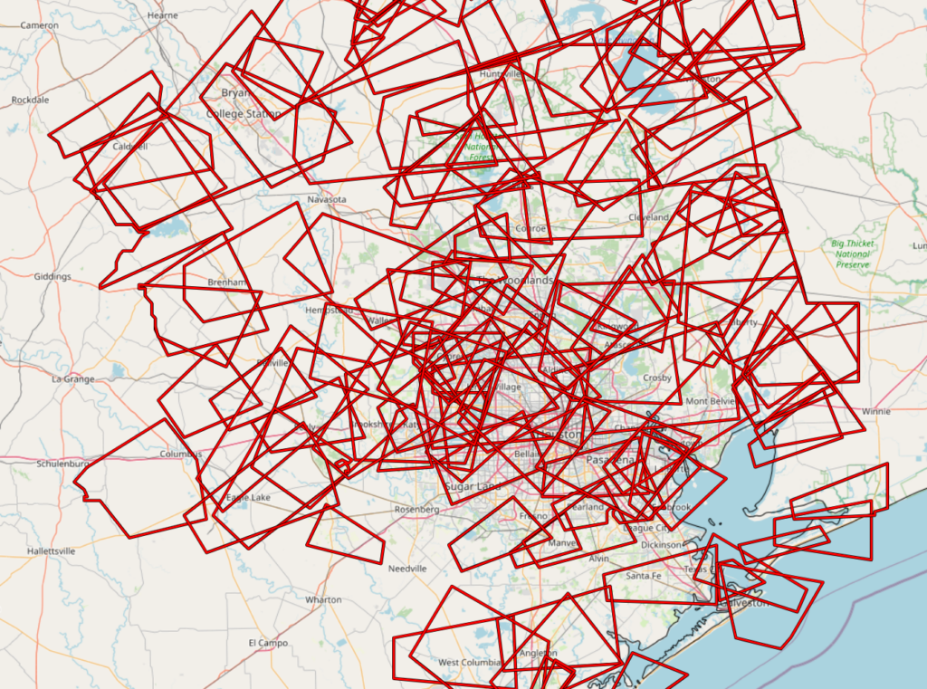
Every tornado warning issued in the Houston area since 2020. (Iowa State Mesonet)
We get a lot of tornado warnings in the Houston area. Since 2020, there have been 136 of them issued by the NWS Houston office. The typical tornado we get here is a little different than what you see in the Plains or Midwest. Our tornadoes here are most often quick spin ups in squall lines (what we call QLCS tornadoes) or brief south to north moving supercells in the spring or fall ahead of cold fronts. Also, tropical systems. Harvey alone in 2017 led to over 140 tornado warnings. The QLCS and tropical tornadoes are a bit like playing whack-a-mole because they usually flare up and weaken rather quickly or sometimes look like they’re about to produce a tornado and do not. In the Midwest, you often have a little time to see them coming. Here, it’s just a different reality.
That said, after the derecho this month, I think that it’s apparent that folks should take these warnings seriously, even if they are inconvenient at times.
–Matt
Q. Can you please not use an apple as a comparison tool for the size of hail possible? Is it an gala apple? Is it a red apple? Is it a green apple? Is it a honeycrisp apple? Is it a pink lady apple? Is it some random miniature apple? Or is it ping pong to baseball sized?? 1.5 to 3.5 inches wide or 3.8 to 8.9 centimeters wide is easily accessible to most people. And fun fact the National Geodetic Survey (NGS) has updated their definition of a foot as of 2022 to better match international standards. An apple is completely subjective.
A. You forgot the most important argument in favor of apples. They’re delicious.
But just like my Granny Smith, you make a good point. The next time I’m writing a post on my McIntosh computer, and we’re expecting hail, I’ll try not to be so confuji in our terminology. Honey, I’ll try to be crisp in our language. Hope you find that apeeling.