The Houston region will be a bit warmer today, but then will have about five superb days of spring-like weather before May begins. At that point, I expect we’ll begin to see the end of this glorious run of spring.
Wednesday
We’re going to see some warmer weather today, with mostly sunny skies and light southerly winds allowing for highs to nudge up into the mid-80s across the region. I wouldn’t be surprised to see some areas south of Houston push into the upper 80s. In any case, it will be warm—a harbinger of how early May is likely to feel.

This won’t last, however, as a cold front is on the way. It should push through Houston sometime tonight, probably a few hours before midnight. The most likely scenario is that we’ll see a broken line of showers and perhaps a few thunderstorms with the front’s passage tonight. However at this point I still don’t expect everyone to see rain, and areas that do probably won’t see more than a tenth or two of an inch.

Thursday and Friday
The rains should end before sunrise on Thursday, and we’ll see clearing skies during the morning. The rest of the work week just looks simply amazing. We’re talking highs generally in the upper 70s, lows in the lower 50s for inland areas, mid-50s for the city, and lower 60s for the coast. We’re talking lots of sunshine. And we’re talking light winds.
Saturday
Moreover, this time the exceptional weather won’t end when Saturday rolls around. The day will start out cool, in the mid-50s, and I still only expect very light northerly, or northeasterly winds. With partly to mostly sunny skies, we can expect high temperatures to rise to about 80 degrees during the afternoon, and winds will probably shift to come out of the southeast later in the day.
Sunday
Sunday morning will be a few degrees warmer, as the onshore flow begins to get in gear overnight on Saturday, but highs during the mostly sunny afternoon should be about the same—around 80 degrees. If you’re riding into Austin I’d expect a tailwind at you back for the BP MS 150.
Next week
We move from April into May on Tuesday, and that’s about when I expect us to jump back into more normal weather for this time of year (see the graphic below, of the “temperature anomaly” forecast).
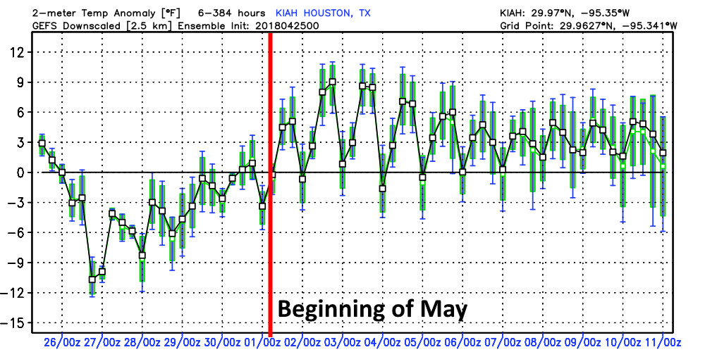
This is to say, that we’re going to see more days in the mid- and upper-80s soon, with more regular humidity, and considerably warmer nights. All good things must come to an end, and so too it goes with this spectacular April weather.
I seem to recall a similar spring two years ago when we did not hit 90 until early June. Crossing my fingers we can do that again.
I remember not hitting 90 degrees until late; but I don’t recall April being so darn nice.
Due to an insurance mess-up while transitioning policies, I’ll be without flood insurance for 12 days, from May 1 to May 12. This makes me nervous, because we’re right around the time of year the Memorial Day flood and Tax Day flood happened (fortunately, the house did not flood in the Memorial Day flood or Tax Day flood, but, you never know…). If I could even get private flood insurance on such short notice, it would be exorbitant. Are there any indications of a major flood event over the next 2.5-ish weeks? Thanks as always for all your help!
No. I do think there is the possibility of 1-2 inches of rain on the weekend of May 4-6 in association with a possible front, but nothing too extreme.
I remember May of 2013 when we Houston set the all time record low for May at 42. The afternoon of May 3rd did not get out of the 60’s and that was pure sunshine and no clouds. I will never forget that.
Sounds lovely!