On Monday, I noted on Twitter that this is the nicest April in Houston I think I’ve ever experienced. Later, no less an authority than JJ Watt concurred.
Weather in Houston has been phenomenal lately
— JJ Watt (@JJWatt) April 24, 2018
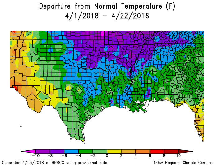
He’s correct. This month the region has generally see a cold front every three to five days, which has kept humidity down, and temperatures slightly below normal—about two to four degrees for most of the area. We’ve also had enough rain to keep things green around the region, but not so much that precipitation has lingered for days at a time.
Alas, all good things must come to an end. The outlook for this week remains spectacular, however it is possible that next week (it is not clear yet whether a strong front will push all the way through Houston) will begin a warming trend that heralds the oncoming of summer. Either way, enjoy the rest of this glorious April.
Tuesday and Wednesday
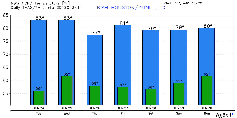
We’ll see a bit warmer conditions today, as a light onshore flow begins to return to the area. Highs on Tuesday and Wednesday will climb into the low 80s (possibly mid-80s on Wednesday), but skies should remain mostly sunny. By Wednesday night, a cool front will move through the area. This front will probably bring some scattered showers and thunderstorms into Houston after midnight, but nothing too extreme and I don’t think anyone will see more than a few tenths of an inch of rain. The front and storms should move offshore by sunrise on Thursday.

Thursday and Friday
The end of the work week looks really nice. Skies should clear out by Thursday afternoon, and we’ll have lots of sunshine on Friday. Both days should see dry air, with highs in the upper 70s to 80 degrees, and cool nights with lows in the upper 50s in Houston—warmer closer to the coast, and cooler for inland areas.
Saturday
Conditions for Saturday look exceptional. The area should see high temperatures right at around 80 degrees, with partly to mostly sunny skies, and fairly low humidity. If you’re riding in the BP MS 150 or participating in the IRONMAN Triathalon, morning temperatures will start out in the upper 50s, with what is likely to be a light northeasterly wind. Overnight lows on Saturday night will drop to around 60 degrees.
Sunday
Another very nice day, with sunny skies and a high of around 80 degrees. Winds will be southeasterly, so if you’re riding into Austin, the winds should be at your back.
Next week
We’ll see a warming trend heading into next week, with highs in the mid- or even upper-80s possible by midweek. After that its not clear whether another front moves in to cool us down, or we remain warm. Rain chances return by Monday or Tuesday.