Did it rain on you yesterday? Or were you, like me, left jaded? I’ll tell you one place that saw some rain: Sienna and Arcola on the Brazoria/Fort Bend County line. Radar estimates that nearly 7 inches fell just west of Hwy 6 and 288 in Arcola.
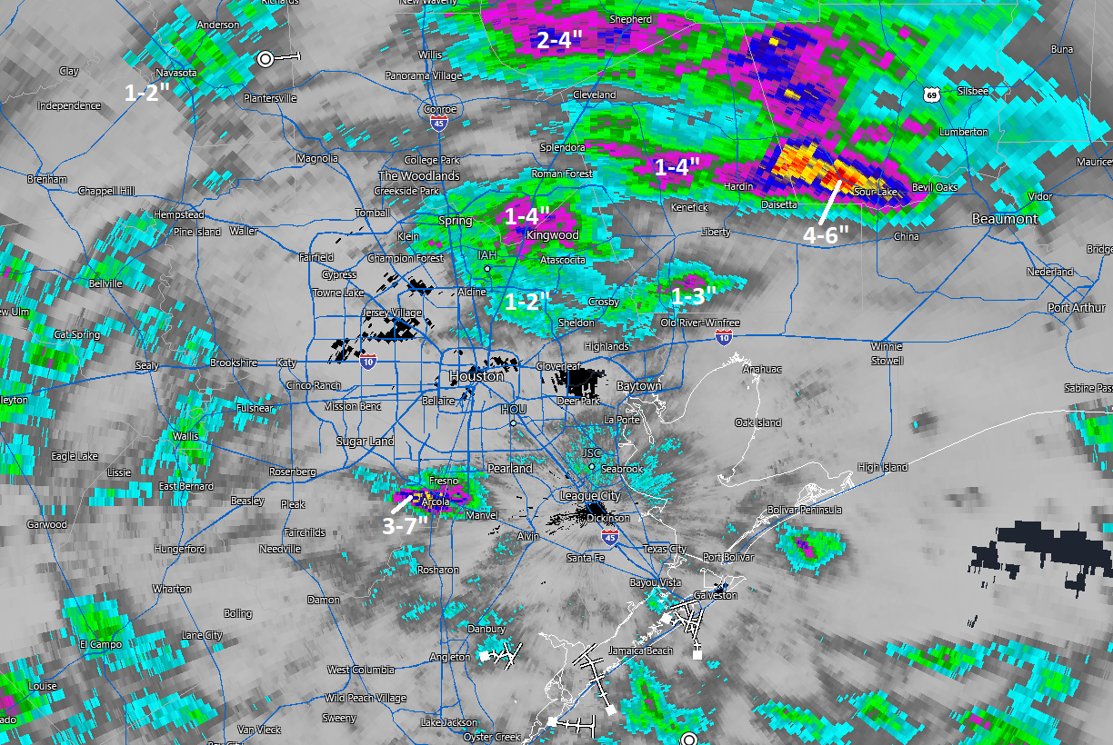
Heavy rain also delivered for Spring, Humble, and Kingwood with a healthy 1 to 4 inches or so. One of the storms up that way prompted a few warnings and did produce a 46 mph wind gust at Bush Airport. The 2.19″ at Bush were the most in a day since we essentially did just that (2.18″) on July 6th. The most widespread heavy rain fell across southern Hardin County to our east, back into portions of northern Liberty County.
Anyway, Matt here today, and thanks to Eric for covering me on a couple recent Fridays as I’ve been knee deep in shepherding The Eyewall along.

Between Idalia and Lee, we’ve had some stuff to talk about. Thankfully, the Gulf looks quiet for the foreseeable future. I want to thank y’all for your support of the site. It’s been fun to watch it slowly grow and pick up a few new dedicated followers from places like SoCal, Florida, and the Canadian Maritimes. Please continue to spread the word to your out of town friends and family.
Today
Rome wasn’t built in a day, and droughts don’t end in a day. Usually. But, hey, for the third day or so in a row, we have rain chances on the menu today. Are they high rain chances? Not especially. But expect at least some scattered showers or isolated thunderstorms with downpours. The best odds may be to the south and west of Houston. As has been the case this week, those downpours could add up quickly in spots and cause some brief street flooding. We will watch to see if perhaps a more vigorous disturbance could produce a more organized area of storms at some point later today to deliver a little more widespread rain. But that is not certain.
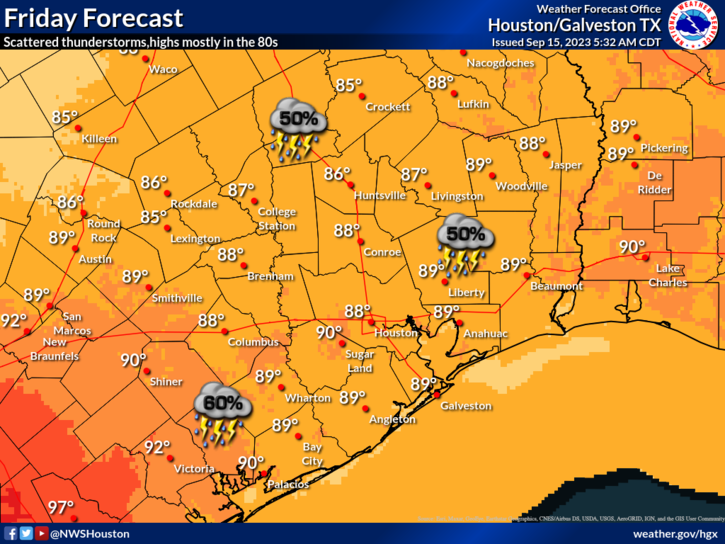
Clouds will keep temperatures in check in spots. With rain, expect upper-70s to low-80s. With sun, expect near 90 degrees or a little hotter, with plenty of humidity to boot.
Saturday
Look for yet another day with rain chances. Again, many folks will see nothing. But just the fact that we have strung together multiple consecutive days with showers in the area is nice to see again. Anyway, I think the focus of rainfall tomorrow may be south of I-10 or southeast of Hwy 59/I-69 and toward the coast. But we’ll see. Expect morning lows in the 70s and highs of about 90 degrees or so.
Sunday
I would go forth with whatever plans you have Sunday without worrying too much. There will be a slight rain chance, especially toward the coast as a weak front pushes offshore. This should lower the humidity some and allow us to peak in the low-90s after a morning in the 70s.
Next week
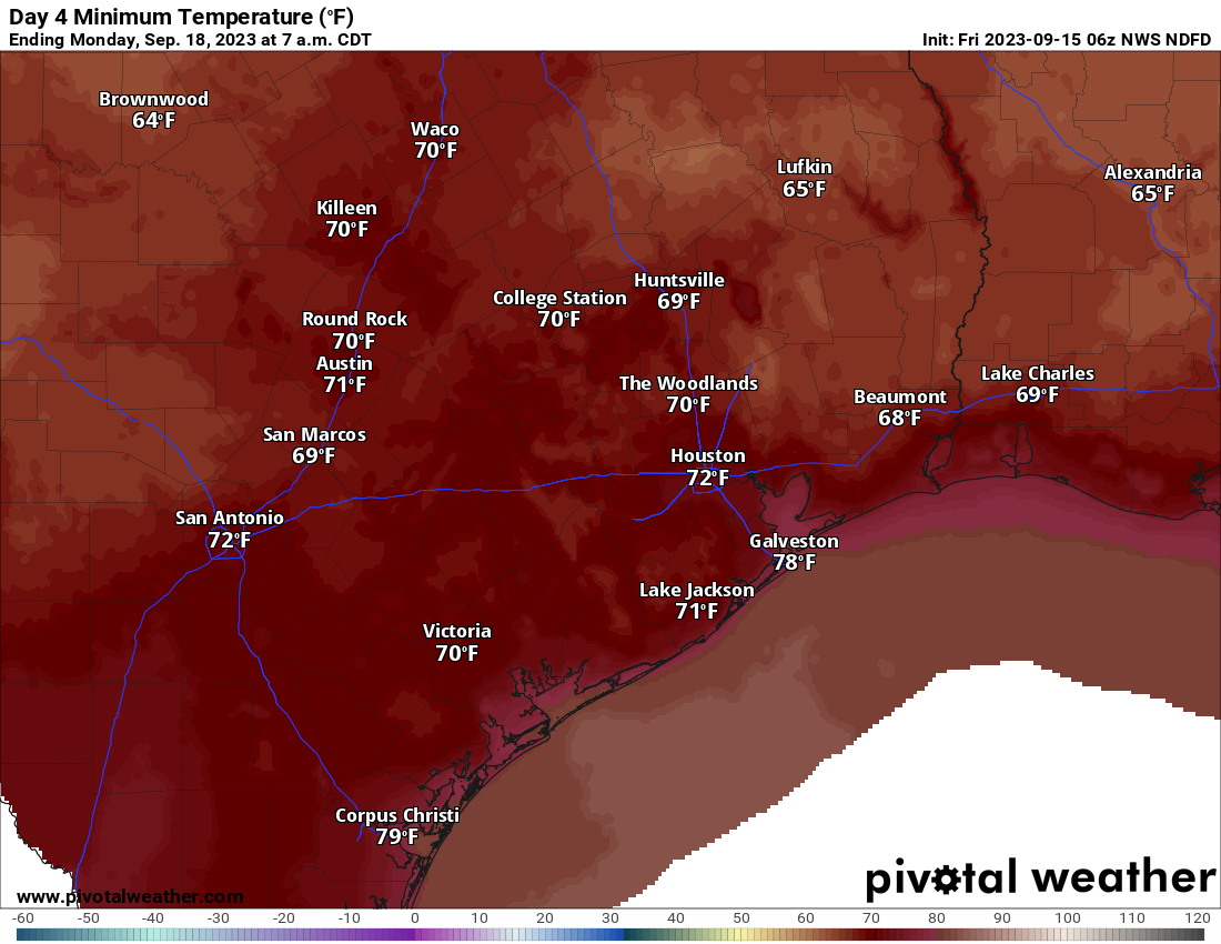
The good news is that the Sunday front will actually yield a relatively pleasant morning Monday and perhaps Tuesday. Look for morning lows around 70 or so (with a few spots in the 60s) followed by daytime highs in the low-90s.
Temperatures heat back up for the middle and end of next week and we may temporarily see rain chances return. We continue to see virtually no sign of a legitimate autumn cold front over the next 10 to 14 days. So late summer continues, perhaps into the end of September.


We got heavy downpour at about 4am this morning in Liverpool. 😁 Finally!
Yes, during the day I got only .4″ was disappointed but heard thunder this morning and when I checked I had got another .7″! total 1.1″ I’ll take it!
We got an inch Thursday between 1:30 am and late morning in Montrose near the River Oaks Shopping Center on West Gray!!
I’m in that 3-7 inch swath, and can confirm we had about 4 1/2 inches of rain fall in just 90 minutes from roughly 3:45 pm to 5:15 pm yesterday. It was glorious to finally hit the rain lottery after these past 4 months of nothing. Crazy. Nothing on the radar, and then a small cell appears out of nowhere and basically trains in the same location and the skies just open up. Hopefully a few more spots get lucky today – especially if they’ve missed out on the good news up until now.
Yep 4.25″ inches near Southwest Airport in Arcola!
“Drought never brought dearth.”— George Herbert
1/2″ to 1″ here in Friendswood of the much needed rain. Not a drought buster but a start.
0.1
Yeah, same…thinking mid 90’s is completely doable. Its that meme with the dog in the burning room ….this is fine.
I’m the outlier, but I’ve always found mid 90s days to never be that oppressive. it makes me feel better to see others, after being subjected to real oppressive weather, are coming ’round.
when I start seeing high temps over 98, that’s when I put the brakes on outdoor activities.
this summer hasn’t changed that for me.
We got .54″ at my house yesterday, good for the trees and bushes and grass. Hope to get some more today!
I live in the Steep Bank East section of Sienna. We were definitely in that swath of heavy rain too., 4.75″ fell at my house between 3:40 pm and 5:15 pm yesterday. The peak rate of rainfall was right at 5″ per hour for most of that time. My pool almost overflowed. The overflow drain could not keep up. It is feast or famine. The last time we had any meaningful rain was back in early July. Same scenario as yesterday; massive rain is a very short period of time.
Another .11″ overnight, and it is lightly raining again right now (8:50 am).
It’s raining now (9:00) near Westchase, hope it keeps it up.
The radar estimate doesn’t show it, but we got a good 2 inches at least down here in La Porte with two strong storms during the day. Got myself soaked even with a raincoat on both times.
Got a 5 minute shower yesterday. Not the widespread rain predicted. If the next two days have less rain chance, then we won’t get any more.
My family and I could use one of those, wake up to dark stormy Saturday morning thunderstorms drinking coffee and looking out the window……SIGH
A high BELOW the 90 degree mark? That’s Pumpkin Spice Latte weather, amigos!
Halloween has always been the summer/fall transition for me. I remember that when I would go trick or treating or take my kids out, it could either be burning hot or freezing cold.
The sound of rain was music to my droughted being 🎶🎵🎶
We got a good downpour here in the River Oaks area : enought to cover the patio with 2″ of H2O ~
Nearly 2 inches here, about 3.5 for the month.
Wow!….So much cooler than I expect each time I step outside. It was 78 degrees early evening yesterday. That’s lower than the regular nightly lows of 80 and overnight 90s for much of the evening (before midnight) in past weeks. I’ll take it! Here in Oak Forest area we are stringing together a .10″, a .40″, and another .10″. The grass is helped a bit, but the trees and lower soil levels are still in drought mode. As long as most days carry a chance of rain next week and as long as the evaporation rates are markedly lower, we can play the “slowly but surely” catch up game and get out of the drought…maybe by year’s end. A cool front would be nice for next weekend. Can we order one? Is there a delivery charge? 🙂
We are 6 miles south of the Sienna Arcola rain and got none of it. .2″ earlier in the day. Sigh.
Figures. Nice line of storms moving in from the west. And just like clock work the storms are splitting up just before reaching our area. I can see storms to the south. Storms to the north. Looking west I see blue skies. Here in 77095 we have had exactly .02″ of rain. Doesn’t even qualify as a trace. Bummer. You know what, though, if I go outside the air feels very dry. My humidity gauge is showing 77%.
I’m in Rosehill Tomball. Literally all the storms missed us. 0 rain. Both days
Round 2 started down here in Sienna at about 3:00 or so. TONS of lightning and thunder. Really close to us. Power went of once for about two minutes or so after one of the lightning strikes. We are up to just over 1″ more of rain, and still coming down at like 2″ to 4″ per hour…. My heart and brain cannot take this any longer. .
Could you post a link for local rainfall tracking?