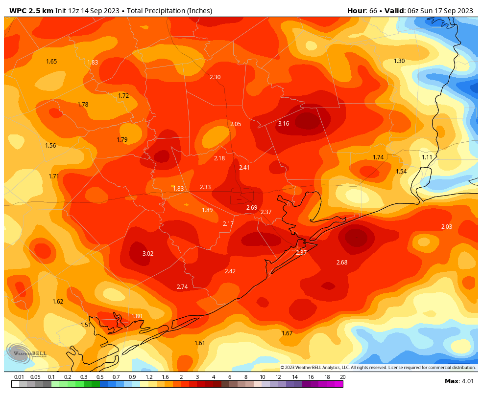
Good morning. As anticipated, much of the area on Wednesday along and south of Interstate 10 recorded rainfall. Today, widespread showers will extend across most of the rest of the region as an atmospheric disturbance moves in from the west. This will provide lift for the very moist air at the surface, and should lead to some healthy showers and thunderstorms.
We’ll see some additional rain chances on Friday and Saturday, but all indications are that today will probably be the main event. I would expect that most (but not all) of the area will pick up 0.5 to 2 inches of rainfall today, with lesser accumulations possible on Friday and Saturday. Although a few intense downpours may briefly produce street flooding, these rains will, by and large, be very much welcome after our summer of heat and drought.
Thursday
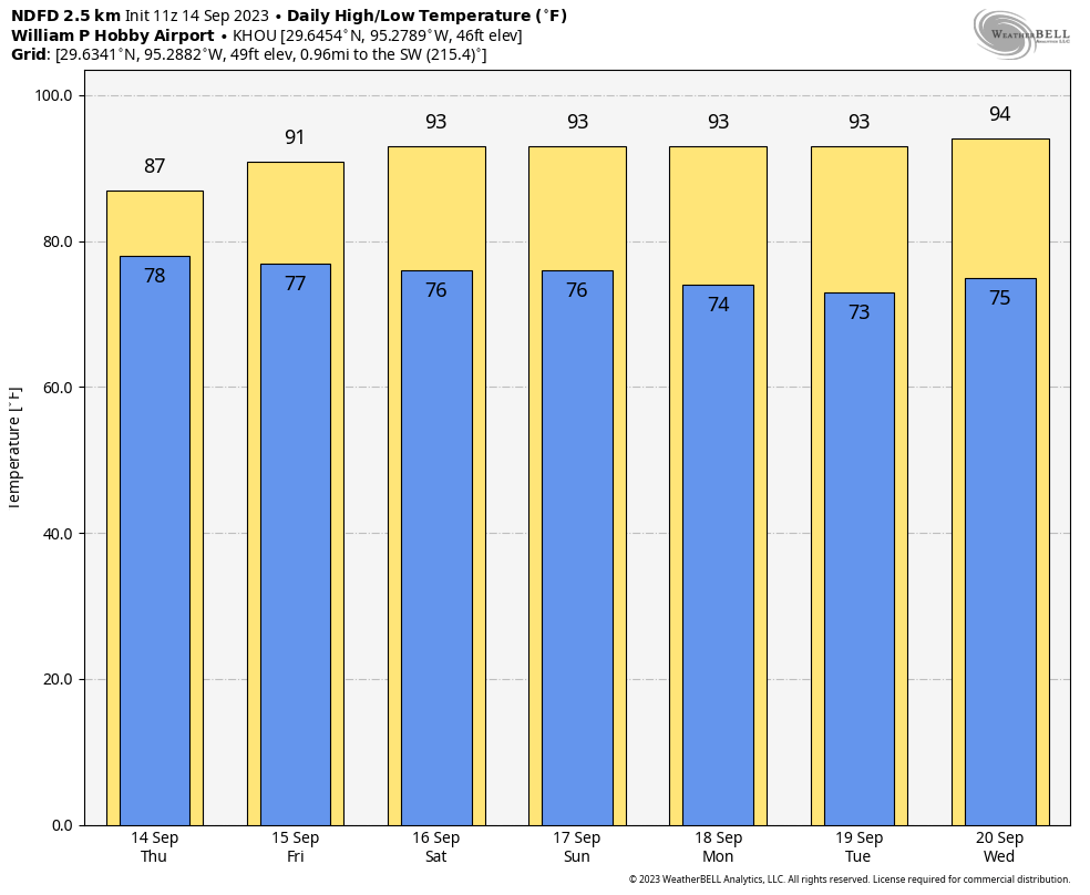
Overall rain chances will be about 80 percent today given the favorable environment. Based upon the latest modeling I expect showers and thunderstorms to start developing by mid- to late-morning, with the greatest coverage during the afternoon hours. With mostly cloudy skies and rain cooled air, much of the region probably will record highs today in the mid- to upper-80s. Rain chances will slacken some overnight, but additional showers are possible.
Friday and Saturday
As of this point, both Friday and Saturday look to have similar weather conditions. We can expect partly cloudy skies and perhaps a 50 percent chance of rain both days. In terms of accumulations, both days may see rain totals measured in tenths of an inch, with a few higher isolated totals. Rain chances will persist into the evening and overnight hours. Both days should see highs of around 90 degrees.
Sunday
It now looks like a lesser chance of rain will persist into Sunday, probably something like 30 percent. Skies will be mostly sunny otherwise, with highs of around 90 degrees or a bit higher. Sometime on Sunday a weak front will push offshore, ushering in some slightly drier air into the region. This will effectively end rain chances, and should allow lows on Sunday night to drop into the low 70s for most of the area.
Next week
The slightly drier air should hang around for Monday and Tuesday, leading to some decently pleasant mornings and evenings. Highs will likely top out in the vicinity of the low 90s for most of next week, perhaps reaching the mid-90s toward week’s end. As the humidity returns in full force by around midweek, we should start to see the return of a few clouds and rain chances of perhaps 20 percent each day. This is about how mid-September should feel as we await the true onset of fall in the form of a strong-ish cold front. (For which there is nothing in sight, I’m afraid).


Just over 1/10 inch at my home in Bellaire and a prospect for more today 🙂 I don’t need to turn on the soaker hose.
Radar shows some heavier rains developing out here around Sealy along I-10 and moving east, the frustrating/ridiculous part is they’re popping up to the north, south, and east, while in town all we’ve gotten is a light sprinkle, lol!
Today is my winter day. It started off cloudy and cool.
Got over an inch between last night and this morning already! Very satisfying! finally an end to the 66 days without rain!
Blessed rain!
Drove down to Galveston last night, what a downpour! I got to experience the phenomenon of Texas drivers forgetting how to drive when it rains firsthand.
First real rain for me in two months at Shadow Creek Ranch in west Pearland last night. Very welcome sight!
It feels like we finally broke through something. So grateful for my trees to have a really good natural soaking again. We had glorious actual, measurable rain overnight and it’s raining again now. I took my time coming in from the back of the yard. Quite happy to change out of my rain-soaked clothes. Hope everybody gets a little of it. Be safe driving out there if you end up in a downpour. The gutters and drains haven’t been tested in a while.
Well, after the promising radar this morning, the rest of the day’s action skated around us again. Sad trombone.
“Yes Lawd!” Is all I have to say today.
About 5/8″ rain, very disappointing after all the hype. 🙁
We have had o” so far at my house.
0.00″ at my house today 🙁
Same for Timbergrove. Less than a quarter of an inch. All that hype was much ado about nothing, yet again.
Seems to just bypass the area in-between magnolia and the woodlands. I am beginning to think that rain is a myth.
Not even a drop in acres homes!!
😂 As of 1:15 pm today in Alden Bridge in The Woodlands, there is some strange, alien substance falling from the sky. Could it be that the Indian moon probe actually found water on the South Pole of the moon and is sending it to Earth? Hope the stuff doesn’t have any dangerous “moon microbes” in it! 😂
What is going on? Water is falling out of the sky!!
Zero rain in central spring branch. Very disappointing in light of the increased potential for over an inch. Need to run my sprinklers tonight! Losing faith in the outlook for rain over here.
Same in Timbergrove. What happened to the “area will see widespread rain of 0.5” or more”?!
College Station got some rain. It was not much, but there were some puddles. Glad to know it CAN still rain here.
Not a drop since July. Watching the weather radar as storms literally go around around us right now. Why? 🙁
Jersey Village, dry as a bone.
“I am El Nino. Yo soy El Nino. For those of you who don’t habla espanol, El Nino is Spanish for: The Nino.” – Chris Farley
The sub tropical jet is really picking up steam typical of El Niño autumns and winters so get ready for a pattern shift from drought to cool and damp.
We had one 5 minute shower. First one in Cypress TX since July 4th. Thanks Mother Nature for hating on us (again)
It’s been nearly a total bust for us in SE Katy area. Lots of thunder and rain around us. I just keep waiting and praying.
Just south of Cypress and haven’t received jack 5hit
The largest recorded climatic event in history not really covered by media. HONGA TONGA volcanic eruption January 2022. Could effect global weather for years. Look it up!!