Good morning. Lots to discuss this morning from heat this weekend, plenty of activity in the tropics, and longing for the season’s first real cold front.
Thursday
Moisture levels are falling over the region, but they’re still high enough to squeeze out some scattered showers and thunderstorms. By now you know the drill; most of the area probably won’t see rain, but the areas that do could see brief, intense thunderstorms. Highs should make it into the mid-90s under partly sunny skies.
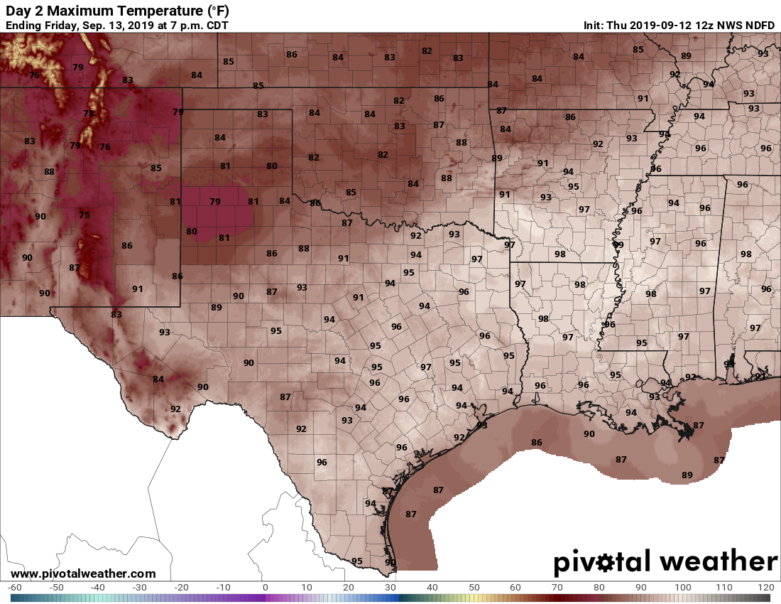
Friday and Saturday
High pressure should reign, making for a pair of mostly hot and sunny days for the Houston region. Look for highs in the mid- to upper-90s. These will be some of the last really hot days of 2019 for Houston as we get deeper into September.
Sunday and beyond
Our weather for the second half of the weekend and next week will depend on the track of Invest 95L, discussed below. Most likely, we will begin to see elevated moisture levels pulsing in from the Gulf of Mexico, leading to a 30 to 40 percent chance of rain from Sunday onward. But overall confidence is not particularly high. The question is mostly whether we’re mostly dry, or see a pattern of scattered showers and thunderstorms each day. Highs should be somewhere in the low- to mid-90s.

Tropics
As one might expect in mid-September, the Atlantic tropics are sizzling. The National Hurricane Center has bumped up development chances for Invest 95L, now located near the Bahamas, to 80 percent over the next five days. There are some questions about where the center of this tropical disturbance will actually set up, and that will help determine its track. At present, most of the better modeling suggests a more northward formation, leading to a track that brings the storm to Florida, or keeps it east of the state, off the coast, like with Dorian. In any case, this is more tropical weather the Bahamas does not need. There is a lesser chance of a formation to the southwest, in which the bulk of the tropical system could drift westward, into the Gulf of Mexico. This might significantly increase Texas’ rain chances next week, but seems like the lower probability scenario for now.
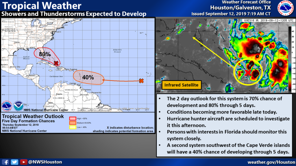
There is also another system out there with a 40 percent chance of developing over the next five days. Right now, the odds appear to be against this system tracking toward the Gulf of Mexico.
Cold front
Lastly, a lot of you have been asking about the possibility of a cold front, and believe me, we’re desperately looking for one too. For the first time, the global models are seriously flirting with a front in the Sept. 21 to 25 time frame for Houston. Confidence in 10 day forecasts is low, but at least we now have a glimmer of legitimate hope.
Come on cold front!
21st – 25th? Ouch. How does that compare to historical first fronts? I know you shared a graph in the past with that type of data, but I couldn’t begin to remember when.
In a post last September, they loosely defined a first front as the first time with a <65 deg F min temp. This came out to be around 18 September, as shown here: https://spacecityweather.com/wp-content/uploads/2018/09/First65MinTemp.jpg
Thank you!
That is in line with history.
I see the data now (thanks Tim L.) I suppose it feels late because I’m so ready for the heat to end. Appreciate all the hard work.
“…so ready for the heat to end.”
You and me both man, you and me both.
My desire for it to hurry up is in line with history as well.
C’mon cold front! I have my first 5k race on 22 September; need some cool air.
Doh! I’m supposed to leave in 10 days for my Florida vacation. Will be following closely. Thanks for your forecasts!
Good Morning
Thanks for the update; just a lot of rain next week or…something more? if the disturbance will move into the Gulf?
I think the range of possibilities for next week are from little rain to some rain. Probably not “a lot” of rain.
Thanks guys. I am beginning to believe that Microsoft is testing a new rain repellent software and SE Texas is in the Beta Test. Really hope we get something out of 95
My wedding is September 21st! Hoping for that cool front and for good weather! I am ok with rain just nothing tooooo crazy!
Hoping for good weather on the 21st as I am getting married! Rain is ok (ceremony is inside) but just hope nothing significant threatens this day! Thanks for the reliable info!
oh no those poor east coasters might be in for a double whammy.
Last run of the European model I saw had 95L going into NJ, another model had it going into SE Texas then back out again. In other words, too soon to tell.
Soooooo, you’re saying there’s a chance!?!
Nobody wants a storm here, but let’s hope and wish that the Bahamas manages to dodge as well. That poor country does NOT need another storm…even a minor one.
“For the first time, the global models are seriously flirting with a front in the Sept. 21 to 25 time frame for Houston. Confidence in 10 day forecasts is low, but at least we now have a glimmer of legitimate hope.”
I’m clinging to this hope like Grim Death.