Over the last 5 days, most of us have seen at least some rainfall with a smattering of storms each day. Not all of us have seen significant rainfall, however.
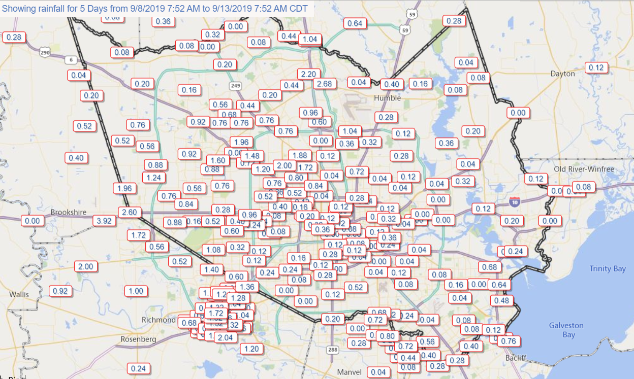
Apologies for the map that is clearly excluding some parts of the area. If you’d like a bigger view, you can view recent rain totals at Harris County Flood Control. Amounts of up to 2 inches or so have occurred near Acres Homes, Sugar Land, and out by Katy, with higher amounts in a few spots near there. Then, you have spots like the East End, far northwest Harris County, and some pockets south and also northeast of Houston that have registered little to no rain at all. For those seeking rain, we’ve got nothing good to report for the next couple days.
Today & weekend
Today and tomorrow should be fairly straightforward forecasts. We should see ample sunshine and hot temperatures. Look for daytime highs in the mid- to upper-90s both days. Nighttime lows into Saturday morning should get to the mid- to upper-70s. If we’re looking for a bright spot in the relentless heat, it’s that the nighttime temperatures and humidity levels will not be terribly oppressive. Heat index values should be mostly under control.
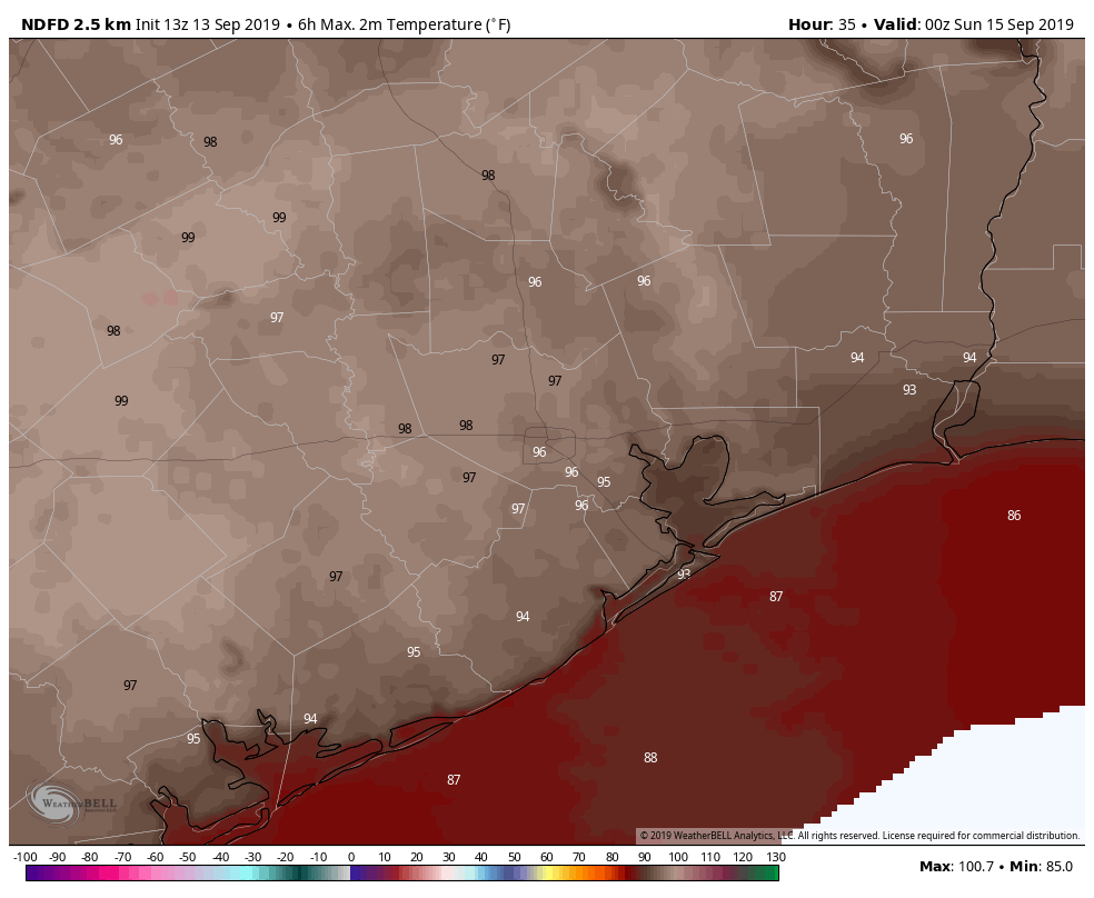
Sunday gets a tiny bit trickier. Moisture from an area of low pressure in the upper atmosphere will take over most of the western Gulf but primarily offshore. We should see at least a few showers being flung toward Galveston and other areas southeast of Highway 59/I-69 on Sunday morning or afternoon. But most places will probably stay dry. We’ll start in the 70s and end in the mid-90s.

Next week
There is still a bit of uncertainty on exactly how that upper low in the Gulf is going to behave in terms of daily showers and storms. Right now, I would expect a mix of sun and clouds each day. Showers and storms may develop along the coast and gradually build inland through the morning and afternoon. There may be a day where storms are fairly concentrated along the coast and inland areas see nothing at all. But Monday through Wednesday or even Thursday look this way. Outside of that, it will be hot and humid. Look for low- to mid-90s during the day and upper-70s at night.
Rain totals will vary, with perhaps 1 to 2 inches along the coast and less inland. That said, there could very well be higher amounts in some areas.
Tropics
The good news is that we have no real serious concerns in the Gulf. The National Hurricane Center declared Potential Tropical Cyclone #9 yesterday off Florida. That was the system we had been watching this week. That is expected to slowly develop into a tropical storm and come close to the Florida and Southeast coasts.
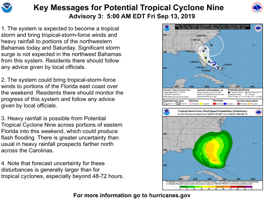
There is still a good bit of uncertainty on exactly how close this system will get to the coast there, so interests from Florida to the Carolinas should watch this.
Behind PTC #9, there are a couple tropical waves that could develop in the central Atlantic Ocean. While we will keep an eye on these disturbances since things can change, we don’t see anything right now that concerns us in the Gulf over the longer-term.
PTC #9…another “wish” storm.
Eric,
What’s your personal “magic date” after which Houston has historically been safe from tropical issues? October 1?
According to the post of September 25, 2017, after that date in the year the chances of a storm hitting Texas drop to about 1 in 50.
Yep. September 25 is a nice benchmark historically. Obviously, every year is unique, but with ~150 years of records for Houston tropical cyclones, it’s a pretty good threshold.
September 25th is about the average day when the fronts start coming, once those are in place then nothing is getting through the gulf.
From my layman point of view, I think we’re in the clear already. High pressure has been keeping any storms just east or south of us. NOAA has forecasted a active next several weeks. So Florida and the SE will be under the gun. Unless we get a front porch storm so to speak. We might be done already.
Should Alabama evacute?
OMG, IKR?!?!?!
No, but maybe Katy better………..
Some of the spaghetti models show a 2% chance of tropical storm winds in a 1 square mile area in the far southeast portion of the state, so clearly Alabama will be hit much harder than expected.
Yesterday, you mentioned that some models were starting to hint at the possibility of a front in the long range outlook. Any updates on that?
Not really. There isn’t terribly strong support out past 9/20 yet on models. But roughly 20-25% of the individual members of the ensemble we look at show some chance. So it’s not especially likely, but it’s a possibility. Basically, nothing we can hang our hats on yet.
Sigh….
I just moved here from Colorado and am scratching my head. i knew the summers would be crazy hot, but kind of expected it to cool down to at least the 80s in the early fall. Is this normal here?
Yes.
Yep, this is September in Houston. I think this September is a little hotter than normal, but typically the early month is still low to mid-90s each day with plenty of humidity. The late month is upper 80s to low 90s most days, unless we get that first fall front…then you realize why you moved here. Sometimes that’s in September, other times it’s in October. You’re usually in more of what you would expect autumn in Houston to be by mid-October. Being from the Northeast, I loathe the month of September down here.
Matt, I am also from the Northeast and start to get homesick around this time… wishing for a cold (or even a “cooler”) front ASAP!
Yes, it’s super normal. I never understood why Back to School clothes are for cold weather until I lived further north for a bit!
Welcome to Texas! Yep, this is normal. But even some of us natives are feeling like this is pretty late to go without even a small cool front, maybe something to at least cool our nights off. (The data probably says it’s average but it FEELS ridiculous.)
Typically fall doesn’t begin here till about a month after Pumpkin Spice Everything shows up in stores. My dad always says October is when God comes to Houston.
Remember that cold front we got for 2 days in July? We’re paying for it now.
I think what’s different about this year is that the big summer ridge of high pressure is still lingering, while most years it’s moved off so temps will top off in the low to mid 90s and will also allow for more rain or cloud cover to further keep down the temperature. And while some have pointed out that the first front doesn’t normally come through by now anyway, we usually at least see them get close and perhaps stall out near us, which can provide further clouds and rain as well to keep temps lower.
As my old neighbor tells me all the time, in Houston we only have two seasons, Summer and Not Summer.
How about Summer and Less Summer?
The list I saw in a Houston Chronicle article was:
Almost Summer
Summer
Still Summer
Christmas
I have a question regarding weather technology and the flooding that has occurred with “holiday” and tropical storms/hurricanes. Do you feel current technology can now alert us ahead of these incidents so we can be more prepared?
How quickly we forget. We had an early cool front back on July 24th. 65F. Coolest I can remember. That being said, c’mon fall cool front.
Once again, Matt, thanks for covering the tropics even when our area isn’t in the mix. I flew from Houston to Orlando today and am currently looking out over the beach just south of Cape Canaveral. It’s breezy and the surf is very rough but pleasant enough to sit outside. We saw no indications that the locals were ramping up in expectation of a tropical storm this weekend. Hoping the cone of uncertainty keeps inching eastward or our vacation will consist of working jigsaw puzzles inside, which, of course we could do in Houston far cheaper!
Looks like Alabama is in the crosshairs once again
Appreciate the weekend update!
Hoping for “some” rain, but not excessive as we are STILL rebuilding from Harvey…..uhhh, will it ever end!?!?