This morning we touched upon the likelihood of a tropical system coming into the Gulf of Mexico this weekend, and now that the National Hurricane Center has declared this a tropical depression there has been heightened focus on the system. As the depression is currently under low wind shear and over warm water (nearly 85 degrees), we can expect this to become Tropical Storm Nate soon. Before we discuss the track and intensity forecast for this storm, I want to be clear that at this time we really do not view this system as a significant threat to Texas.
Track
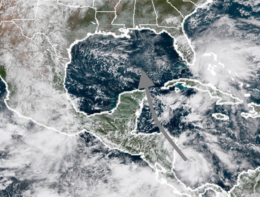
The system will interact with Nicaragua over the next 24 hours as it moves north, and perhaps Honduras and Belize, bringing significant rains to those locations. There is general agreement that it will get pulled into the Gulf of Mexico by Friday night or Saturday morning, perhaps passing over northeastern tip of the Yucatan Peninsula, or moving through the straits between the Yucatan and Cuba.
After that time there’s some uncertainty. The GFS model (12z run) wants to keep the system on a north-northwest track, and bring it into Louisiana (or possibly even eastern Texas). Here’s a map showing the ensemble forecast for the “center” of the tropical system on Sunday morning:
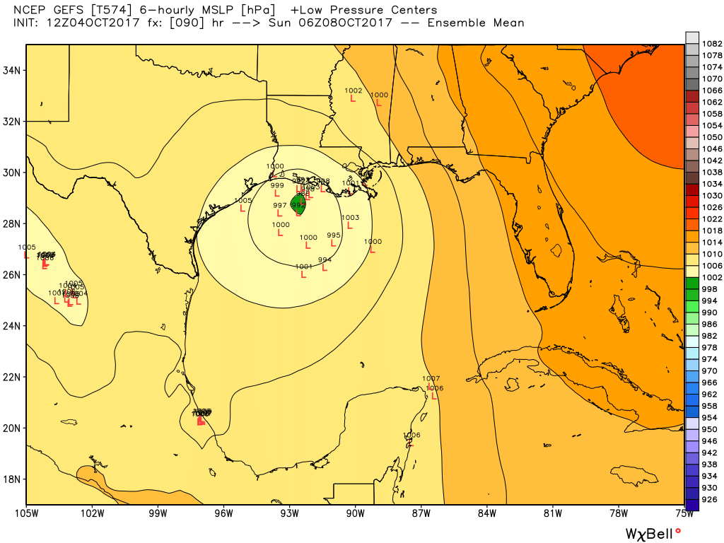
You might look at this and be somewhat alarmed, given the proximity to Texas. However the GFS doesn’t seem to be handling the overall pattern very well, and you would think that if this storm followed such a track it would become quite a bit stronger than what is shown here. Therefore, I would discount the GFS model at this time.

Most of the other guidance is east of the GFS model, showing a landfall in southeastern Louisiana, Mississippi, Alabama, or the Florida Panhandle. For example, here’s a look at the 12z ensemble forecast from the European model:
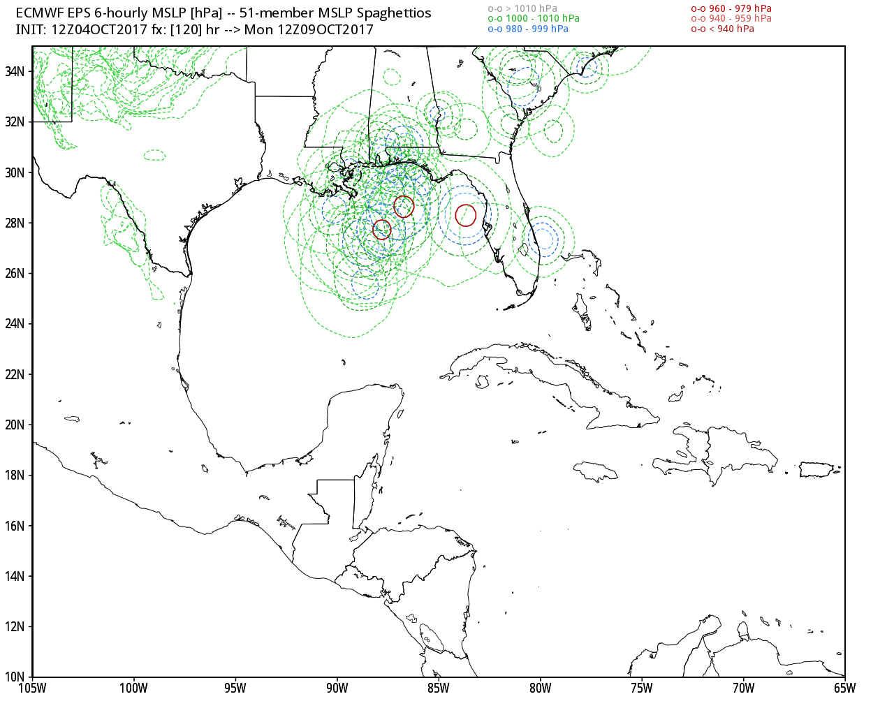
From a meteorological standpoint, this seems like a more realistic scenario. The bottom line for Texas is that while we cannot entirely rule out significant effects from this system, the overall steering pattern in the atmosphere should keep this system east of Texas. If I lived in Louisiana, including the New Orleans area, I’d be watching it fairly closely. We will, of course, continue to track it.
Intensity
This is a really tricky forecast. While the depression remains over favorable waters for intensification now, and should soon become Nate, interaction with Central America could weaken it significantly. So we’re not sure what kind of system comes into the Gulf of Mexico this weekend.
With that said, once there, it should find generally favorable conditions in the Gulf this weekend. The National Hurricane Center calls for an 80-mph Category 1 hurricane by Sunday morning, and that may be too conservative depending on how much time the storm remains over water. I’m not ready to rule out a small, but fairly intense hurricane. But being perfectly honest, the intensity forecast is kind of a crap shoot right now.
Thanks for the heads-up. We will keep an eye and be aware. Great job with the data sans hype. Blessings.
Thanks for the update.
Assuming worst and best case scenarios, what would be the impacts for the Galveston/Bolivar coast? Thanks.
I’m headed to New Orleans Friday for a long weekend, what should I expect?
Expect to be drunk.
Hilarious
Interested in whether it will affect Belize as that’s our favourite place for a getaway & they don’t have much defence against vicious weather.