After a stormy Tuesday, the rains should be over for now, as high pressure builds over Houston and somewhat drier air works its way into the region. For us, the next two big events to watch for are a tropical system in the Gulf of Mexico, and a much-anticipated cold front next week. Let’s discuss.
Wednesday through Friday
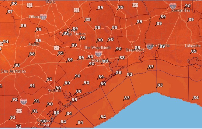
Building high pressure should lead to mostly sunny skies—look for highs in the upper 80s—along with warm nights with lows around 70 degrees. Aside from the late-summer like feel to the weather, we should have no concerns.
Saturday and Sunday
For now, the weekend simply looks pretty hot, with partly to mostly sunny skies and highs near 90 degrees. Lows should only fall to around 70 degrees. The good news is that after this weekend I’d say there’s only about a 50 percent chance of seeing another 90-degree day this year, so the end of summer really is nigh.
The caveat to this weekend’s forecast is the tropical system likely to form in the Gulf of Mexico, which could bring us some increased moisture and rain chances by Sunday—although for now I’d bet against that.

Cold front
The timing isn’t certain, but we’re still on track for a cold front to swoop into Houston next week, probably some time on Tuesday morning. The front looks fairly strong, but because we’re still about six days away the forecast isn’t locked in stone. So please take the following temperature forecasts as guesses, rather than certainties. But for now, I’d expect most of Houston to fall down to the upper 50s for lows, if not colder, and areas further inland to see nights in the mid- or lower-50s. Dewpoints should be quite low, which will make the air feel much, much drier. High temperatures by the second half of next week might only be in the 70s.
Tropics
By now you’ve probably seen the five-day forecast from the National Hurricane Center showing the likely formation of a tropical storm in the Gulf of Mexico this weekend.
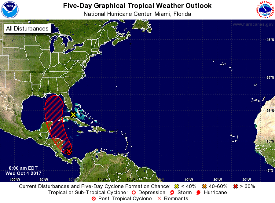
We have to offer the usual caveats here, namely that without a well-defined center of circulation, it is difficult to forecast tracks for a tropical system. However, it seems most likely that this system will respond to the cold front next week by turning north toward Louisiana, or northeast toward the Panhandle of Florida. This is the solution favored by every member of the European model ensemble, and we have no reason right now to doubt the model.

There is some potential for this system to become a hurricane (perhaps a fairly strong one) by early next week, and we’ll have to watch it closely for impacts along the northern Gulf coast.
Thanks again for the insight, Eric. We here in Texas were worried about this new system/gyre. But looking at your work and also looking at other sources, the ensemble models to project it to be a north turn from LA to FL potentially.
As always we will keep our guard up and wait to hear from you. Myself I can confidently say that I’m ready for all of this to be over. Would be nice to have a good 5-8 months without having panic attacks anytime the tropics swell.
Just walked by the TV at 8:20 as NBC’s Al Roker was talking about the system threatening NE Gulf you mentioned in this post…at the end of that he said something about more flooding in Texas…was that a “hyped up” or a “loose lips” comment, you think?
I caught that as well. I thought he was talking about the rains in Central and SW Texas. Not that it was connected to this system. He worded it weirdly though.
Seems like the last couple fronts were promising several days out and fizzled by the time it got here. Fingers crossed this one packs a full fall punch!
“…so the end of summer really is nigh.” -ah. music to my ears…
I am curious about the great traces on the Euro Model “ensemble” graphic. I have heard that the European Model incorporates sensors packages on many commercial airliners, and use this large global dataset data to improve the predictions. So what do the grey lines represent?
So, it seems we will be protected from two hurricanes this year dues to the RIGHT timing of the cold fronts. Irma was pushed away from us by the previous cold front and this new one will also be chased away by another cold front just-in-time 🙂
we are due to go to the florida panhandle in 10 days so watching closely, if a hurricane does develop, will it likely be over by then? Thank you!