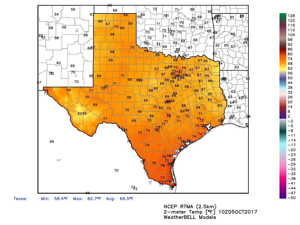
It’s been hot in Houston. Wednesday’s high temperature reached 89 degrees, and the nights remain humid. This late summer-like pattern will remain for about five more days, before a cool front arrives next week, most likely on Tuesday. In this post we’ll also discuss Tropical Depression 16. (Update: This became Tropical Storm Nate in the 7am CT advisory from the National Hurricane Center).
Thursday and Friday
Warm, mostly sunny days linger under the influence of high pressure. We will continue to see high temperatures near 90 degrees, with overnight lows around 70.
Saturday, Sunday, and Monday
For the most part, we can expect mostly sunny days, with continued warm weather. However, as the tropical depression—likely Nate by then—moves into the Gulf of Mexico we may see some moisture associated with the storm that produces some rain showers over Houston. I’d bet on hot and sunny, but we’re going to leave open the slight possibility of some rain for now, and issue a forecast with more confidence tomorrow. (Either way, we’re not expecting significant, flooding rainfall).

Tuesday and beyond
There’s still some uncertainty about the timing and intensity, but a cold front remains likely to move through Houston by around Tuesday, bringing drier air and cooler weather. We still have some questions about how cool it will get, but I have some hope that the second half of next week may see high temperatures in the 70s, and overnight lows in the upper 50s or lower 60s. It should feel great, regardless.
Tropical Depression 16
The depression should move over Central America today, bringing heavy rainfall to Nicaragua and Honduras. It should spend Friday moving across the northwestern Caribbean Sea before crossing into the Gulf of Mexico on Saturday morning. The forecast models have come into better agreement during the overnight hours, zeroing in on a landfall location from the central Louisiana coast to the Florida Panhandle, with New Orleans as the most probable location for now. This is reflected in the narrowing cone of uncertainty in the official forecast from the National Hurricane Center:
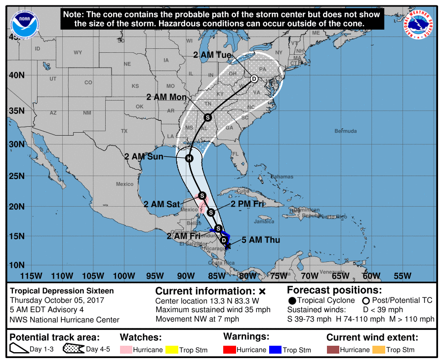
Less certain is the storm’s intensity, which may be fairly ragged after interacting with Central America today. The most likely scenario is that this system remains a tropical storm, or very weak hurricane, as it approaches the northern Gulf of Mexico coast this weekend. However, given the Gulf’s warmth, and some hints from a few models, we cannot rule out rapid intensification on Friday, or especially Saturday. So right now, while winds are not a major concern for the northern Gulf of Mexico coast, they could become one.
As for rainfall, the “good” aspect of this system is that high pressure to its east should help accelerate the storm northward, meaning that affected areas won’t see the kinds of never-ending, stationary rains produced in some hurricanes. (cough, Harvey, cough).
…and as soon as you posted this, National Hurricane Center upgrades to “Nate”, so it’s official.
Always so precise and never full of hype or drama. Thank you so much for giving me peace of mind when it comes to these things. Your report is the first I check before I give any of the news channels my attention. It’s very much appreciated.
We had planned on taking the kids to new Orleans this weekend. The main attraction is Friday night so we will still go but is there any chance any of Saturday will be salvagable?
I think I speak for everyone here when I ask… should Katy evacuate?
Pretty distasteful. Many of us in Katy had to gut their homes from severe flooding from Harvey.
Katy takes the June 1st Mandatory evaluation pretty seriously so I’d imagine they have already left 😜
And Roy, it dates back to Hurricane Rita, the evacuation was a disaster, in part, to people north and West if I10 heading the evacuation order
What is a bit disconcerting is the shift in the forecast to the west a bit. Yesterday it was Pensacola, today it’s NO. Hmmmm.
Madcougar92, Katy is to the west of Houston and Nate is projected to hit to the east. I think if they are not recommending evacuations for Houston, Katy should be fine too. Or am I misunderstanding the nature of your question?
Jose-
The Katy reference is an old joke going back to the days when Eric worked for the Houston Chronicle. It brings back good memories of how Eric was the calm during the storm (may have been Ike) even to folks far inland (like in Katy) who were very concerned about what to do.
Ah! Thanks for the clarification!
Just got to thinking: between Harvey, Irma, and Nate it looks as if the entire US Gulf Coast will have been hit during this hurricane season. How common is that? I would assume a bit rare.
I think there is a standing recommendation (extended beyond hurricane season) that everyone evacuate Katy TX and hunker down someplace less boring
bahahaha this is a solid comment
I thought I was the only one who still heard a voice in my head ask if Katy should evacuate when a storm is coming. That still cracks me up.
Ugh, the National Weather Service is no longer showing the front reaching Houston. No cool air next week – just more of this gross hot and humid air that seems to never leave this city.
They are still showing the front reaching Houston. Look at their graphic here before they change it, JD:
http://www.weather.gov/hgx/
We will have continued October warmth until a cold front moves through the area Monday night through Tuesday morning. Cooler temperatures (especially morning lows) behind next week’s front.
Galveston is having record high tides I was wondering if you had any idea what that’s about One website showed it as a 100 year high and then showed tide levels since the 60s and this genuinely seems to be a 100 year high
WARNING!
The 12z CMC showed the Florida low sucking in Nate, becoming a tropical cyclone, and hitting Texas! You need to blog on this, Eric!
The CMC is an outlier (and while it’s running right now so not final), looks like it’s coming into line with the other models.
Given that no recent runs of the “big 2” have shown anything like what the CMC is showing (not even the ensemble members as far as I can tell), I wouldn’t put too much stock in it.
We’re all a bit tense with recent events, but a wary eye (not worry) is probably the right response.
But here’s what Brooks Garner said at 3:11 PM today:
While its ultimate landfall is still not expected to impact Houston directly, several computer models suggest it’ll track farther west — toward Texas — than earlier outlooks. I’m still thinking it’ll miss us by a fair margin, but it could slam our neighbors to the east, in Louisiana.
The reason I don’t see it nudging far enough west to directly hit Houston (despite a stout, blocking area of high pressure over Florida) is due to upper-level wind patterns ahead of a cold front. That force should guide the storm safely to our east. (That cold front should ultimately push into our region toward the middle of next week. Ahead of the arrival of the pleasant, drier air, atmospheric steering winds will beginning to veer from west to east. Like a gentle hand, it’ll tend to push Nate east, away from Texas.)
Nate will get sandwiched between a high pressure zone over FL and upper level winds associated with a cold front, steering Nate away from Texas. (Nate’s depicted in red and yellow — colors representing falling air pressure toward its center).
That aforementioned area of high pressure — expected to grow over Florida — is why it now seems Nate will impact Louisiana instead of FL’s panhandle. The worst weather is still going to be on the east side of Nate, so the heaviest rain, greatest tornado threat and gustiest winds will remain hundreds of miles to our east and may impact the FloriBama region even if the center makes landfall farther west.
Houston may see a few rain showers this weekend associated with Nate, but other than that, all eyes here will be on that cold front next week. (This won’t be a mega front, causing you to run for that old winter jacket in the closet, but will make the air feel much more comfortable. Unfortunately for our confidence in this forecast, the global weather models are now backing away from the front actually making it all the way through, but it does seem like a good bet at least the humidity will go down for a few days toward the middle and end of next week. Regardless the system should get close enough to at least steer Nate away from us.)
There are several things that could still affect the progress of Nate’s track and especially its intensity. As always with the tropics, it’s a fluid and changeable situation, so stay close to the forecast — especially if you have plans to go to NOLA this weekend. They could experience flooding and power outages.
-Brooks
A trend toward Tx. means a trend toward Houston.