Today was certainly a day. First off, we want to express our thoughts and best wishes to those impacted by today’s tornadoes, and we hope that the recovery process presents the fewest amount of headaches that are possible.
Tornadoes of that scale and length are not common in Houston. Since 1993, we’ve had a number of “strong” (EF-2+) tornadoes in the Houston area, most of which have been on the eastern side of the city. Today’s tornado was no exception. Here’s a map of tornadoes since 1993 that are EF-2 or greater. Only one in the immediate area rated an EF-3, which was a short tracked twister near Shoreacres in 2002.
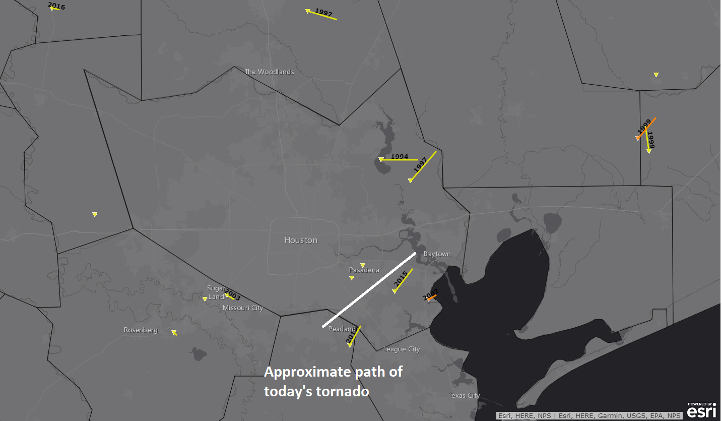
In the tornado records, an EF-2 tornado has never struck the Houston area in January. Why 1993 as a cutoff? Because November 1992 had the king of modern Houston tornado outbreaks, including an F4 in Channelview, which we wrote about a few years ago.
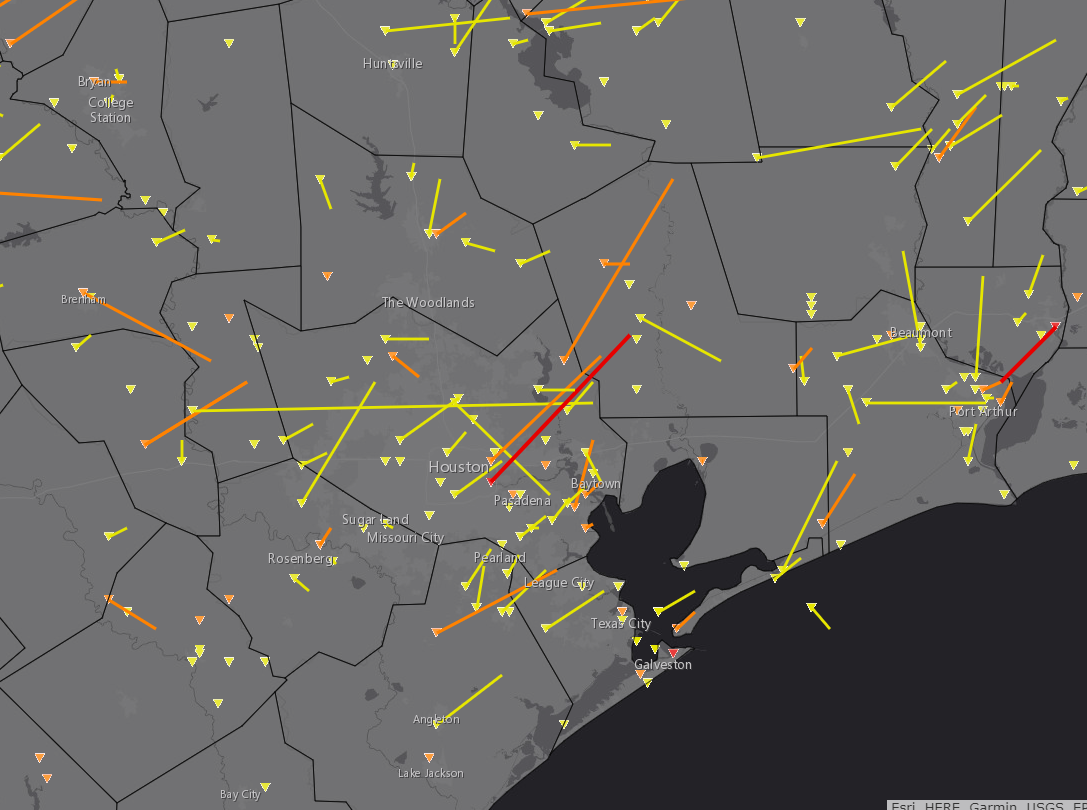
If you’re curious, here’s a map of all known “strong” tornadoes in the Houston region since 1950.
The National Weather Service will be sending out survey teams tomorrow morning to assess the damage and assign a rating to the tornadoes. So we will see if it was indeed a “strong” tornado or not. Remember, the rating is determined by a number of factors, not the least of which is building construction. Some poorly constructed, smaller buildings can be obliterated in a mere EF-1 tornado. Based on the initial photos of damage, I am guessing it will be at least an EF-2. But the NWS folks are the experts on this, and they’ll make that call.
Today also marked the first time a Tornado Emergency has been issued in Houston. We all know about Flash Flood Emergencies from recent years. But Tornado Emergencies certainly represent a new kind of horror for our area. They are rare and only issued when there is a confirmed, likely strong to catastrophic tornado ongoing in a populated area. If ever there were a day to issue one in Houston, today was the day. Hopefully we don’t see that again for many years.
Not to be outdone, the rainfall today was tremendous for January. We still have flooding ongoing out by Mound Creek and Little Cypress Creek in western Harris County. Several bayous ended up at bankfull or even out of their banks today. We mentioned flooding. We mentioned heavy rain. But we probably could have been a little more aggressive on the rainfall aspect of things. Today certainly qualified as a Stage 1 flooding event on our flood scale.
At any rate, we’ll know more about today’s events tomorrow. On a personal note, I want to thank the folks at the National Weather Service, as well as our other colleagues across media here in Houston for a very strong, effective messaging campaign today. Collectively, our messaging and the issuance of a Tornado Emergency by NWS no doubt helped protect lives and property in the Houston area today. For us here at SCW, this is truly why we exist. I saw several comments say that “we saw Eric and Matt really ramp up their messaging today, so it was concerning.” That’s exactly why we operate how we do. We want to be the jovial, informative but not in your face meteorologists 90-95 percent of the time. But on days like today, we get serious and down to business. Houston gets a lot of severe weather “days,” but most of them are low-end potential. They get a lot of chatter and sometimes some hype, and yes maybe on a couple of those days something happens. But we knew this had a unique high end potential for this area, and at least in a couple parts of the area, this potential was likely realized. We are grateful it was not worse. As we always say, we are here to help serve the community, and tomorrow we will be back to our normal, mostly boring selves. But when it’s really, truly time to stand up, act, and pay attention, we will make sure that message gets across. Thanks for your continued loyalty and readership. -Matt


Yes, your messages were what alerted me to the severity of the weather today. Thankfully, I was able to contact my son, who was interviewing at George Bush Intercontinental, and let him know to stay put till the worst was past.
Thanks for helpful messaging!
Matt, I discussed with you the other day on Twitter (@berninbush)… I feel like there needs to be a level in between Tornado Warning and Tornado Emergency. Maybe Tornado Alert? If I’m understanding this post, Tornado Emergency is reserved for when there’s a confirmed “strong” tornado on the ground doing damage. But a Tornado Warning can be issued for “storms that are likely to produce a tornado” even when there’s not yet so much as a radar-indicated tornado. That’s a BIG gap, and it makes Tornado Warnings common enough that people get jaded about their response. A Tornado Alert (or whatever name you give “level 3”) would be issued for an existing strong radar indication of circulation, perhaps with a radar debris signature or spotter confirmation of at least a funnel cloud. Perhaps, as forecasting evolves, there could be a Tornado Alert cone with an expected path inside the broader Tornado Warning area.
I know you can’t single-handedly change how NWS reports these things, but could Space City Weather do their own alerts like you do the flood scale?
I don’t know, the step up to tornado “warning” always gets my attention!!
A Tornado Watch means conditions are favorable for development during the watch period. A Tornado Warning indicates a funnel has been seen either in person or as a ‘hook echo’ on radar.
Not really though. If you read the actual wording on a tornado warning, it says that “a storm capable of producing tornadoes.” They issue tornado warnings all the time when they aren’t sure yet whether an actual tornado has formed or not. I’m just wanting an extra level in between that and “there’s an EF-2 on the ground tearing things up.”
So you want something similar to the number of warnings to how a tropical system develops? Tornado watch,warning,emergency seems to get the point across.
Vivian. After today, I guarantee you will understand the severity of “tornado watch”. As someone who lived in Kansas and had multiple tornadoes tear threw my property, I never take a “warning” lightly
I tend to think adding to the number of alert levels could have the opposite effect, having another layer of complexity to the system which would cause some to ignore it altogether. There’s a certain percentage of people who simply do not respond (or respond negatively) to additional information, no matter how helpful it’s intended.
Y’all are great. True professionals at your craft and my family appreciates y’all! Keep at it!
A fine job by world class meteorologists who can definitely claim “no hype”. You guys nailed it, and for myself, I felt ready. Doesn’t hurt that I grew up in Norman, OK so had a lot of experience. Appreciate all your coverage.
I definitely listen when y’all post more than once in a day.
I live off Waugh, and my street flooded for the first time that I’ve ever seen (I didn’t live in this location during Harvey). It was wild and pretty scary. My thoughts go to those who were way more impacted than I was.
Thanks for all your work. Much appreciated.
I never leave my house without checking for your weather updates!
You are doing a great job, guys!!
You guys nailed it. Nicely done.
‘Like a lion’ … indeed.
Thanks for the work you do.
I don’t listen to anyone other than you two! You are so on top of it and call always be counted on! Thank you!!
Space City Weather is our Holy Grail of weather forecasting! Thank you!
I had to drive through the tornado damage area (down Allen-Genoa) since the Gulf Freeway was closed. The further south, the more wind damage. As I got closer to Almeda-Genoa, I was sure I was seeing tornado damage (from my days growing up in the Industrial Midwest) and also a structure and a fence that had been on fire.
The most dangerous part though were the drivers. The people driving around there didn’t seem to understand how it works when all the lights are out at the intersection. It’s one car from each lane at a time in the same direction. Then the next direction goes. It’s not one car followed by the next guy on the first guy’s bumper followed by a third who guns it to get through while the people who are supposed to have the right-of-way start to enter the intersection. Oh, yes, I got flipped off by the passenger in one of those third cars. Chill out, dude.
Thank you for all you do. I told my children when Eric and Matt say to stay mindful I pay attention!!
Heavy rainfall in the wintertime when the ground is dormant can lead to more flooding as was the case today in my neighborhood and maybe a Flash Flood Warning was warranted as apposed to an urban flood advisory that was issued. Just my thoughts….
I always appreciate your reports. They are very helpful in planning and very well written. Thank you! Dr. Dale Hill
Your work is greatly, greatly appreciated. I chose to work from home, we picked up our kids from school a bit early, and were able to shelter together in the closet during the tornado warning period — and that’s pretty much all because SCW had alerted me how serious things could get today. Keep up the excellent work.
As it goes, I picked this week to not read any news, including y’all. Grateful for the NWS tornado emergency text, and am now off break from y’all’s news. Thank you for all you do.
Your post made me cry, Matt. Thank you for your dedication.
Thank you both!
Thank you so much for being our anchor today, as usual! We so appreciate you guys.
Matt, thanks to you and the SCW team. Thank you for providing the warning and the potential threat as of yesterday. Keep up the great work
Y’all are the best
Thank you both so much for all you do. I really appreciated your heads up for Brazoria county. TV weather hardly ever talks about the southern areas. Keep up the good work!
You warned of severe weather for today last week on Thursday if I recall, I marked my calendar and it happened. Kudos on the accuracy of the call.
Because of your cautions yesterday, my husband and I – who are both disabled – had ample time to set up a cozy movie viewing and comfortable nest in our walk in closet (the safest inner room in our house) just in case we had a tornado warning today.
When we did, in fact, get a tornado warning this afternoon, we were able to swiftly make our way to our shelter and sit in comfort while we waited out the threat. We can’t thank you all enough for your vigilance and communication.
Thank y’all for the diligence and care today, as always. On that historical tornado map above, what year was the one that was the longest yellow track just north of the city?
As always, thankful for the information you all provide and the way it is delivered.
You guys are just awesome. Thank you for keeping us so well informed.
Thank you for being who you are and providing good no hype weather reports always.
Thank you for sharing this. I did not know what tornado emergency meant but know I do. I appreciate your info
I remember the F4 that hit Channelview. My sisters lived in one of the neighborhoods that got hit really hard. Thankfully there was only some roof damage to one of their houses. The damage from yesterday reminded me of that day. My daughter lives across and a little down from the animal shelter that was destroyed. She suffered some minor damage and is feeling very lucky. A neighbor in the next street lost most of their roof. Prayers for quick recoveries all around.
I don’t believe that tornadoes exist. There has never been any proof that they do exist. This is all a plot by liberals and democrats in Harris County to turn us to socialism