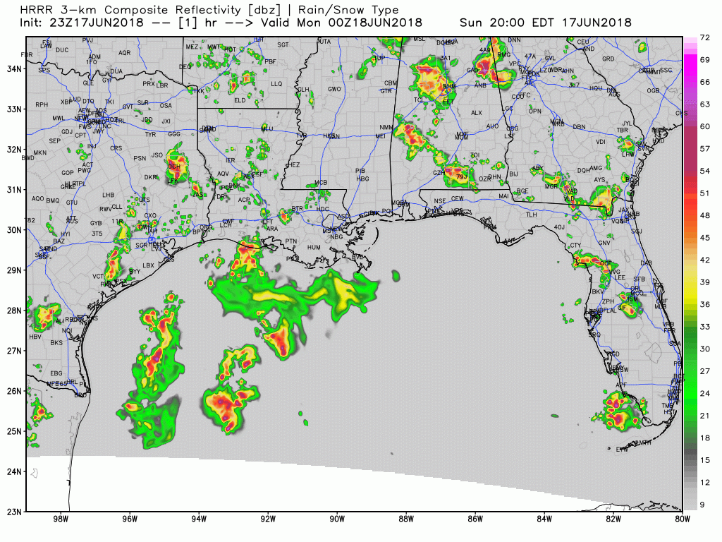
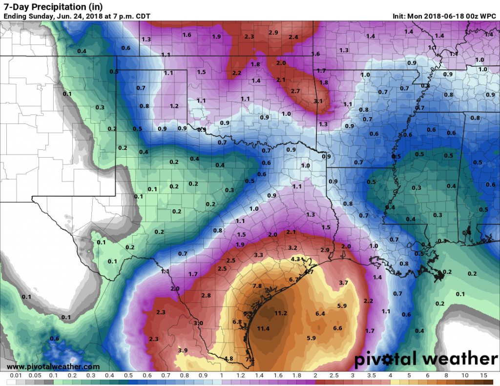
Sunday has gone about as expected—with a smattering of heavy downpours but most of the region receiving 1 inch of rain or less. Monday and possibly Tuesday will almost certainly be different, with the potential for widespread heavy rainfall, and enough uncertainty that we’re going to continue to watch the forecast closely. We will have an update on the site no later than 6am CT Monday.
What we know
The heaviest rains are remaining well offshore over the Gulf of Mexico as of Sunday evening. The general expectation is that as the tropical disturbance moves west, toward the Texas coast, these showers will slowly move toward Texas and southern Louisiana as well.

This inland movement of heavier storms seems most likely to happen sometime on Monday morning, but whether that’s shortly after midnight or well into the day, we can’t say for sure. I’d guess after sunrise, if I had to.
Monday in Houston
Though disorganized, this storm system will bring a lot of moisture into the Texas coast, and this abundant tropical moisture has the potential to produce high rainfall rates in the most intense, isolated storms. However, it is most likely that most parts of the Houston metro area will see 2 to 4 inches of rain on Monday, with higher-end totals closer to the coast, and lower-end totals for inland areas (i.e. on the inland side of Highway 59). These kinds of rain totals may briefly flood streets during downpours, but most likely will not present long-term, widespread problems.
What we don’t know
With that said, some of the forecast models are bringing quite a bit more rainfall—on the order of 6 to 12 inches of rainfall—with this storm over the next few days. We believe those higher totals will occur south of the Houston region, from Matagorda Bay southward the the Coastal Bend and into the Valley, but we do not have supremely high confidence in that. The bottom line, with the remaining uncertainty, is that it’s best to check road conditions before venturing out on Monday morning, and to keep a wary eye on the weather throughout the day. We’ll be here to help.
Tuesday and beyond
The potential for heavy rainfall remains on Tuesday in Houston (frankly, we’ll have a better idea about Tuesday as we see how Monday shakes out), and then the threat for really high rainfall rates should gradually fall off later in the day on Tuesday and into Wednesday. We think.

We probably won’t see much sunshine before Thursday or Friday.

1. Yes
2. Probably. But that decision is probably best made mid-morning on Monday.
3. Because there are a lot of people concerned about it, and there remains some uncertainty about where the heaviest rains will occur.
I live in the South Houston/Pasadena area should there be concern
We really don’t think so, but it doesn’t hurt to be vigilant.
Thank you Eric. Its appreciated very much!
Thank you Eric! My dear Fulgencio and I shared some wonderful jerk chicken with mango chutney tonight in anticipation of the rains! We are so thankful for your honesty so I did not have to comfort him through an ugly cry about floods from the news. We look forward to Monday not in fear thanks to your efforts. Love and blessings to all and hopefully no problems for anyone this week!
That sounds delicious.
Stop being a troll and scaring people “Sky Guy”
Does your research also include all the other times that the same amounts of rainfall caused nothing more than just a bit of street flooding? Fearmongering does nothing positive here or for our community.
Is dear Fulgencio upset over the Spain & Portugal game? Glad Fulfencio & many others are holding strong because of Space City Weather!!!
We seemed to have more confidence days ago about this thing not being much of anything.
What about it has changed that makes you less confidant about rainfall totals and where this thing ends up? Dropping 2-4 inches on Monday and up to another 12 inches in the following two days makes this a significant event in my eyes…
We don’t think there will be 12 inches anywhere near Houston tomorrow, but we can’t entirely rule out the possibility.
2. Isn’t this something YOU need to decide based on weather conditions that day? Eric is a weather forecaster, he’s not here to make decisions for you.
Sorry but I am more than tired of seeing these sorts of posts.
And maybe because even “something in the middle” ain’t a walk in the park either. And. I’d defi tely like to know more – rather than less – here
No, I’m not nervous.
My house in Missouri City flooded during Harvey and I am feeling very nervous, how much rainfall should I expect over next two days? Will there be breaks between storms?
Ask Paul Robison….I think he may be able to answer your question. Maybe even before you ask it!
Appreciate the info, but there’s no guarantee this will be another Harvey. We’re talking a max of 12″ over the next two days. With Harvey we were seeing 10-12″/day easily.
While I understand your concern, this is Houston. We flood all the time. All you can do is keep yourself, family, pets, etc safe and prepare. While it’s dry out now, you might want to go get some groceries/water/etc just in case.
This thing is going to suck, but look at the bright side. Your lawn will be amazing once it dries out!
I get it, SkyGuy, but I don’t think any of us here are meteorologists, this is Houston. Comes with the territory. If you didn’t flood in Harvey, extremely doubtful you’ll flood in this mess.
https://en.m.wikipedia.org/wiki/Addicks_Reservoir
Your “info” came from a website trying to sell a product. I’m not saying it’s factually incorrect but it doesn’t seem to give the whole story. I’m not sure how long you have lived here but 12” over 2-4 days isn’t a particularly big total for Houston.
Thank you for working through the weekend on these updates. I came during Harvey and I check this site every single morning. All the work and effort you put into this site is greatly appreciated.
What should we expect in Freeport area? I work in Friendswood and am curious what’s in store for us.
Thank you Eric! You guys are the best. Calm and reasoned. A lot of us remember vividly when Harvey started flooding our homes. We all have weather PTSD lol. I love getting updates on the rain. Keep up the great work!
I find it remarkable how uncertain the NWS forecast is. Here’s an excerpt from the NWS discussion: “…but not real confident as to exactly where the heaviest rainfall threat will set up due partly to how disorganized the Gulf tropical disturbance is – it could end up being in/around the Galveston Bay and Houston area one day, it could end up being in/around the Matagorda Bay area or even down toward the Corpus Christi area and southward on another day, or we could end up seeing the highest event totals remaining near and just off the coast.”
NWS needs a better way to state the uncertainty level of a forecast. One should not have to dig into the jargon-laded NWS forecast discussion to find this out.
Hey guys,
Love the site. Thanks for all the info.
Where would y’all suggest going to to check road conditions? HouTranstar? Or a couple different sources? Or just looking out the window?
Thanks. Your site is very helpful.
Really?
Somehow, no matter how hard a person tries to be helpful in an honest way, life brings a few jack asses to try and rain on the parade. To “Sky Guy”. Go sit by the bayou and let us know minute by minute how much it’s rising but please inform us from your own website that’s sponsored by no one..Paul Robinson? You need help.
I thought for sure our house would start seeing some periodic showers today but no go. The wife gives credit to me cleaning and washing out the eaves on Friday in preparation for this system. Basically the direct opposite of it raining right after you wash your car.
what the heck??
Thank you for not sensationalizing the forecasts or offering videos of dancing bears or traffic accidents to entertain.
I appreciate your work and your sponsor.
Thanks Eric for doing what you do best! I read your blog every day and it really helps. I also tag you to all my concerned friends. From a flooded Harvey survivor rebuilding and set to move back in July 1.
My cat is having sex reassignment surgery this afternoon in Katy, should I reschedule?
Thanks for your no frills/no sensasasionalism public weather information.
I’ve been viewing WeatherUnderground, Weatherbug, The Weather Channel and KPRC2’s weather apps for the last several days and have made my own assumptions based on the information available from all of them. I think the one app that delivered the best maps so far has been the Weather Channel as their maps are expandable to a worldwide view of what’s going on as far as rain/storm patterns.
I find it odd that I noted a rotation pattern feeding areas of the gulf three days before local news teams made any mention of this. If they believe they’re reducing panic by omitting this information, I can’t understand why. I realize fully a large number of people get nervous, especially since Harvey, when systems brew that threaten the gulf, or any area for that matter. But I do believe most of us would like all information rather than selected information.
I also find it most helpful to have access to world view weather patterns as it really has helped in formulating my own opinion of what is transpiring and how things could progress. I noted the very slow movement of our current system with the possible injection of what was crossing the narrow land mass above the Yucatán, ultimately merging with our current system. And if one had access to all precip in the U.S., and the maps moved with more fluidity, more of us could see the bigger picture without relying on the limited information presented by local meteorological teams. So, I really have a hard time believing much of what they deliver and abhor their use of sensationalizing their reports with use of footage from more disastrous storms when reporting on current storms and stirring up anxiety. We need accuracy and honesty – not a bunch of hyped up crap for ratings.
So – thanks for being clear and simple and admitting to what you are not sure of. Glad I found your site. I value truth, honesty and integrity above all else.
Glad to have you!
Thank you.