Good morning, and happy Father’s Day to those celebrating today. For the most part, the forecast is on track as we’ve been describing it for several days now, but there are a couple things to keep tabs on. And if your travels will take you well south of the area, more toward Corpus Christi, you’ll want to keep a closer eye on the weather. Let’s jump in.
Quick Summary
Here are a few bullet points with the main takeaways that we want to convey today.
- Scattered storms will develop today for much of the area with locally heavy downpours. Probably not a total washout, but you’ll dodge raindrops.
- Heavier rains likely tonight and Monday, particularly southeast of downtown Houston. Areas of street flooding will be possible in heavier downpours.
- Heaviest rain chances should move off to our southwest for midweek, but rain chances stay elevated in and around Houston.
- Total rainfall of two to four or five inches will be the average across the entire area through midweek. There will be smaller, isolated pockets that see higher amounts upwards of seven, eight, or nine inches, most likely closer to the Bay Area or Galveston.
Now
As of about 8-8:30 AM Sunday, the Houston area is all quiet. We have a few isolated showers, mainly south and east of downtown Houston. And for much of this morning, we’ll be fine with just a couple downpours.
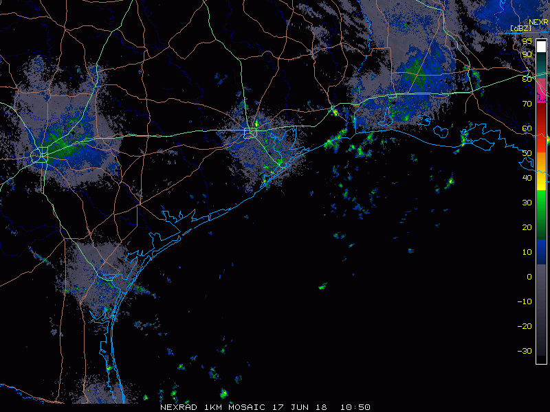
Meanwhile, looking at a bigger picture view of things, satellite this morning shows our disorganized disturbance in the Gulf of Mexico now. Heavier thunderstorms are occurring well offshore. This is what we’re watching for tonight and Monday.
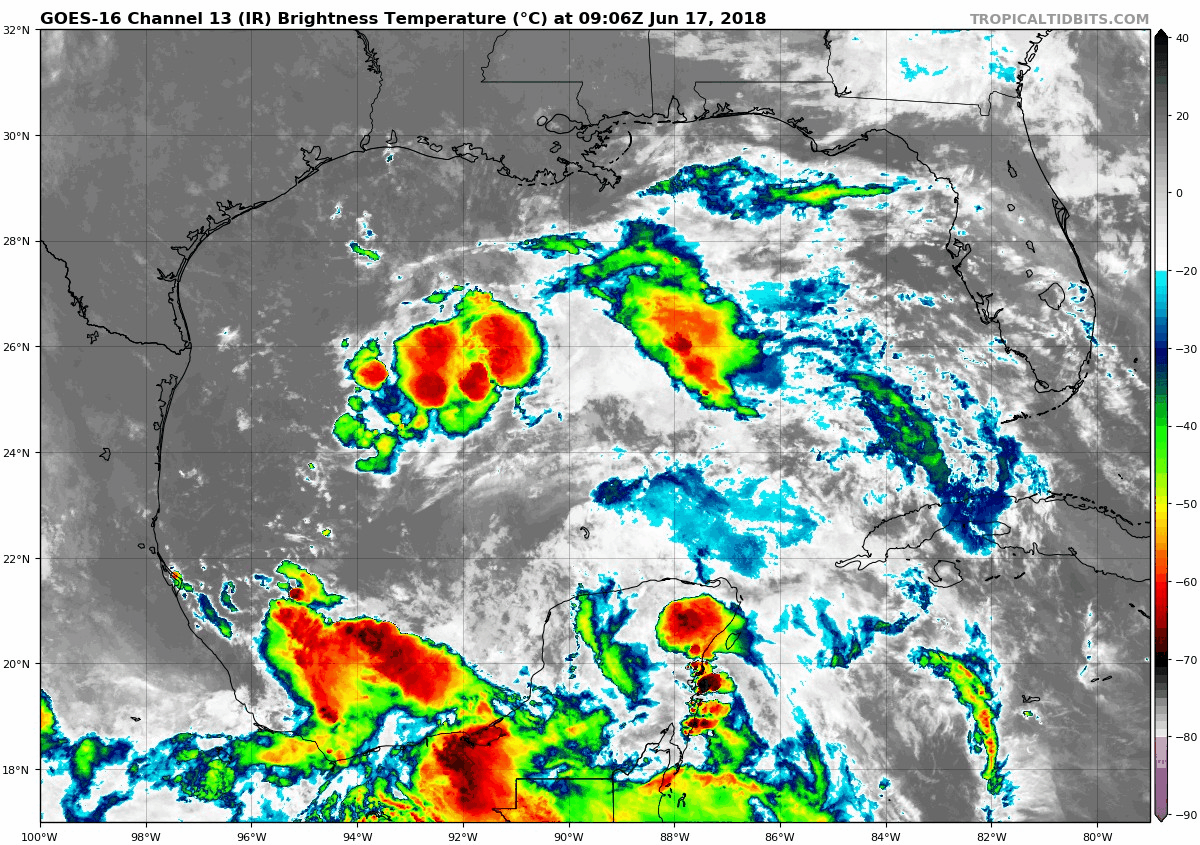
In terms of tropical development, the National Hurricane Center continues to carry a token 20% chance over the next 48+ hours. That’s a fair assessment, and we feel that impacts to our area will be similar regardless of if this thing meets technical definitions or not within the next couple days.
Rest of Sunday
So what can we expect for the rest of today? Well, as this disturbance creeps toward Texas, expect numerous showers and thunderstorms to pop up late this morning and afternoon across most of the area. I’m not going to classify Father’s Day afternoon as a complete washout, but you will likely be dodging raindrops at least once, if not a few times this afternoon. So if you are planning anything outdoors, have a backup plan. Most of the area will see a couple tenths to maybe a half inch of rainfall. Some will see less, and some may see in excess of one or two inches where rains are most persistent. Today’s rainfall will be a nuisance more than anything for most folks.

Sunday night & Monday
The bulk of this rain event will likely occur in this timeframe. Expect numerous showers and thunderstorms in the region tonight and most of Monday. We will likely see any storms dissipate north of I-10 this evening, and it’s possible folks up in The Woodlands or out west of Katy may not see anything at all after this evening until tomorrow morning or afternoon. Near the coast, however, we do expect showers and storms to be a feature most of tonight into Monday morning.
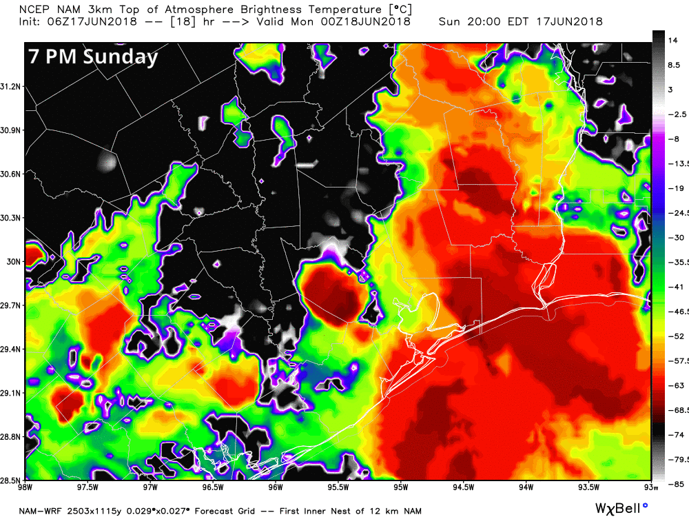
Rains may in fact be heavy at times southeast of downtown Houston, especially along the coast and near Galveston Bay overnight
After sunrise Monday, we’ll see storm risk expand again to most of the area. We’ll have slightly more favorable ingredients to work with for rainfall tomorrow, so expect locally heavy rains throughout parts of the area. I’d expect an inch or so more tomorrow, with, again, areas seeing higher amounts.
Rainfall rates in the heavier storms tonight and tomorrow will be capable of producing some street flooding in parts of the area. That is probably our biggest concern for Monday. You’ll want to give yourself a few extra minutes out the door Monday (and on your return home).
In terms of other impacts, we don’t see too much to be seriously concerned with at this point. Some of the thunderstorms could be strong and produce strong wind gusts, especially along the coast. Rough seas will obviously be a concern offshore. Rip currents will be serious the next couple days, so again, if you swim or surf between rain bands today and tomorrow, please use caution. Tides of 1-2 feet above normal on the coast are likely with some run-up on beaches, but no serious flooding issues. Expect surf to stay up and tides elevated through much of this week.
Rest of the week
After Monday’s rains, our system will shift off to the south and west.
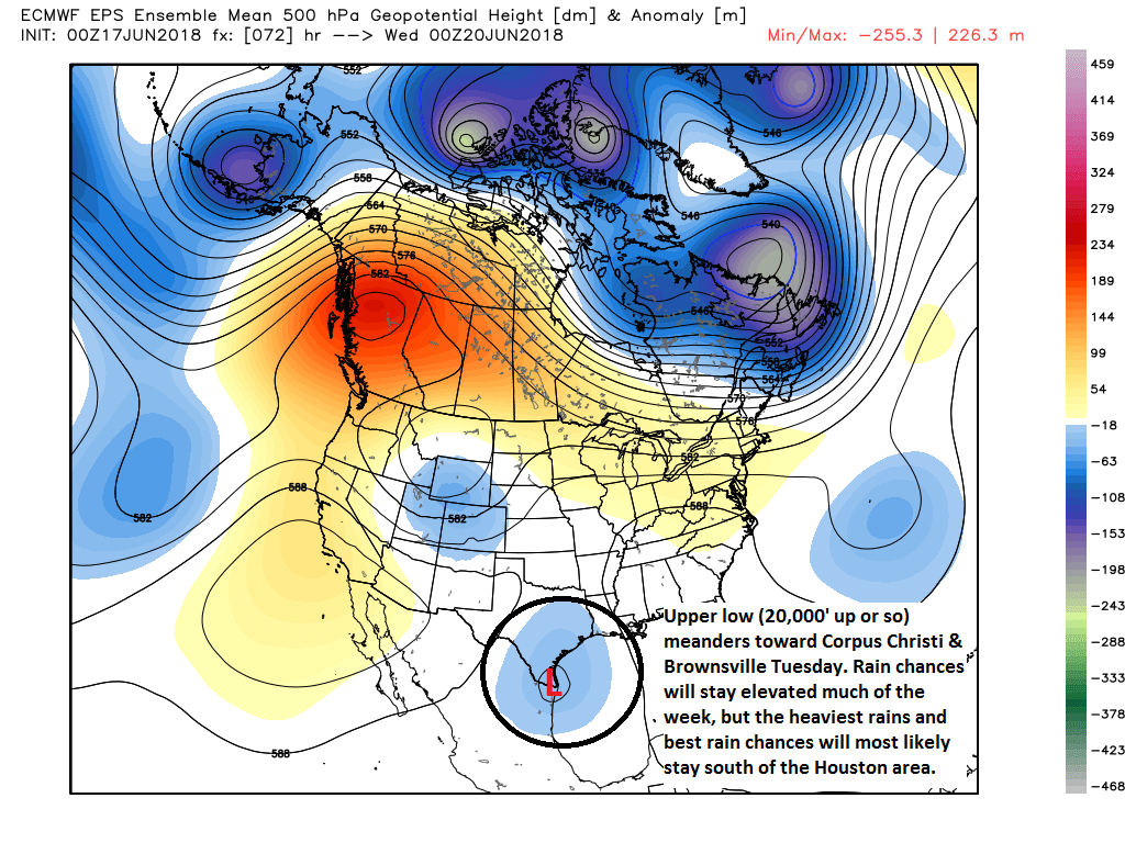
The map above shows that on Tuesday evening, this disturbance will be centered over South Padre Island. That should keep the heaviest rains in the Corpus Christi area or near the Rio Grande Valley. Houston will continue with higher than usual rain chances Tuesday and beyond, but I don’t expect we will see as many showers and storms each day as we will later today and Monday.
If your travels will take you down toward Corpus Christi or Brownsville, you will want to take note of some of the forecast rain totals.
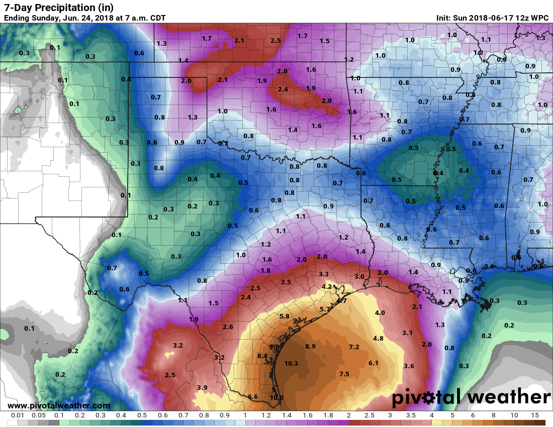
While drought has been much more severe in South Texas than in the Houston area lately, six to ten inches of rain over multiple days between Corpus and Brownsville, with higher amounts likely will cause some flooding problems down that way.
You can also see from the map above that officially, the NWS forecast for the Houston area has not changed much since last week. We still expect, in total, about two to four or five inches of rain around Houston, with higher amounts possible south and east of US-59.
We will continue to watch for where pockets of enhanced rainfall may occur and if there will be a higher street flooding risk in particular neighborhoods. Eric and I will post as needed. I’ll try and tackle questions in the comments, on Facebook, or on Twitter. One common question we get a lot of is regarding travel plans and airport delays: We can’t predict airport delays with any specificity. I would encourage you to have patience if you’re traveling later today and tomorrow though, as delays will certainly be a good bet at some point. Those may linger Tuesday. If travelling somewhere by car, we can’t tell you go/no-go. You will likely hit heavy rain at some point, so please use caution if you go, drive safely, and have methods to get weather information between here and there, especially if you’re headed south of Houston this week.
Are we going to see major thunder and lightning associated with these storms or tropical rain?
There will be thunder and lightning, yes. Major? Not quite sure how I’d truthfully define that, but any thunderstorm in SE Texas can produce a lot of lightning.
Appreciate the analysis. I have a flight early Tuesday morning out of hobby, what does the weather look like then, as best as you can tell? Thanks
Hi guys,
I’m concerned about the disturbance that’s developing over the Yucatán. Should the Texas gulf coast be concerned?
Hi Michele, the whole post is in reference to that disturbance (now over the Gulf). It’s not expected to develop into a tropical storm. But it will be what helps deliver our rains over the next few days.
Matt, thank you for posting this morning. We sure do appreciate you and Eric. The Hwy 249 area around Tomball/Cypress tends to be a bullseye for heavy rain. What can we expect to see in rainfall rates per hour?
Rain rates will vary, but you could see 2-3″ per hour rates in the heavier stuff up that way. Storms will keep moving, but we may see some repetitive storms at times that could cause some street flooding.
Not one mention of a Flash Flood Watch from NWS. This should be a non event just like you have been forecasting for several days now.
Just to be clear, it’s not going to be a non-event. As much as we’re no hype, we’re honest here, and we have been talking about street flooding risks for several days now. Truth be told, I wouldn’t read into no mention of it yet that much. I wouldn’t be shocked to see them put a flood watch on the table by later today for areas south of Houston.
This is nonsense.
We are scheduled to fly into Hobby airport tomorrow afternoon around 5:00. Will we have a problem with that and heading south to Bay City?
Why increased rain chances for “southeast” of town? A weather novice like myself would think it would be Southwest.
The tropical moisture feed will be coming off the Gulf and from the southeast. The intersection of land and water can occasionally lead to what we call a “convergence boundary” which can act to focus rains in that general area. So the southeast side of the region, along the bays and Gulf will likely be most susceptible to rains tonight.
Matt,
Will the rains will be heaviest for the west of 45 and below the I10 corridor heaviest after Monday?
Thanks
Fear not, the Eyewitless News Team’s mobile units will provide 24/7 coverage of every rain drop hitting our city, thus keeping your family safe.
NWS has raised total expected rainfall from this tropical wave in the Champions area back up to around 3.75″ (from a forecast of 1.75″ early yesterday). We got .28″ this morning in a brief but strong tropical-type downpour. (The lawn is happy.) It seems the rain is now expected to extend into Tuesday.
Thanks again for giving us the skinny straight up without all of the B.S. and drama. You’re an asset to the community and greatly appreciated!
Thanks for keeping us updated with honest reports! You all are my go to source for weather info and I love to share your info with friends.
Do you expect things to clear out in the Corpus area by Thursday evening, or will there still be potential for storms through the weekend?
Storm chances won’t be zero, but they should drop off a good bit after Wednesday or Thursday.
Thanks!
Any updates this evening? Rain predictions have gone alarmingly upwards from this morning on other outlets with rains in Houston continuing through Thursday. Would like to hear from you guys if you see any changes that merit such a big change?
I believe Eric will be posting again this evening. But while there have been a couple model solutions that are somewhat higher w/ rain totals, we’re being very cautious. The nature of this rain is that it’s going to be more focused and sporadic than widespread. One day the heaviest might be over Houston, the next over Victoria, the next over Freeport, etc. Just a hypothetical example. I think the forecast we had this morning works pretty well to this point still. I just posted a few tweets on this topic though: https://twitter.com/mattlanza/status/1008493810719043585
Just know we’re watching this closely still. These types of upper low events are tricky to pin down.
Another beautiful day in Port Aransas. Blue skies all day with white clouds in the distance. Rain starting later tonight. Driving home in rain Monday to Cypress.
6:35 PM and all is well. Radar clear for about 60 miles from here. Time for a walk.