Sunday marked the beginning of a surge of tropical moisture into Houston, and Monday represents the second day of what is looking like a four- or five-day stretch of wet weather for the region. The good news is that, despite the soggy conditions we anticipate, right now it doesn’t appear as though we are going to see extremely high rainfall rates that will cause significant flooding. Our best guess for conditions through Thursday, therefore, is sporadic street flooding. If you’re wondering how this affects your activities, it should be business as usual in Houston for the most part. (And if you’ve scheduled an outdoor birthday party, you have our apologies).
Monday
The radar shows scattered, moderate showers streaming into the Houston area this morning, but the heaviest rainfall remains offshore. That should change later this morning and into the afternoon, as a tropical disturbance moves closer to the Texas coast, and inland tonight. We anticipate the greater Houston region will see 1 to 3 inches of rainfall today, with the potential for higher localized amounts under the most intense storms. As you can see in the map below, rain totals will likely be greater near the coast.
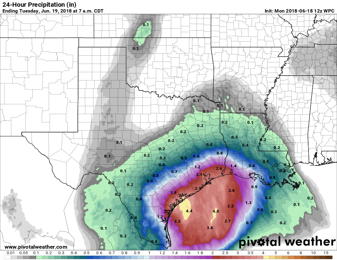
Given these conditions, we do not anticipate widespread problems due to rainfall, however if you find yourself in a heavy downpour, the most dangerous thing you can possibly do is drive into high water. Please, don’t do that. Wait a little while, as these storms should progress through the area fairly rapidly and any flooding should be temporary.
 Tuesday
As of now, the forecast for Tuesday is similar to Monday, with tropical moisture pushing into the Houston region, and bringing an additional 0.5 to 3 inches of rain to the area, again with the higher accumulations more likely near the coast. Any flooding concerns will depend upon where the heaviest rains fell on Monday, and again, at this time we don’t anticipate anything more than short-lived street flooding. However, given the tropical nature of this rainfall (which carries the potential for high rainfall rates), and the overall uncertainty due to poor forecast model performance, we will continue to watch the situation closely and update as warranted.
Wednesday and Thursday
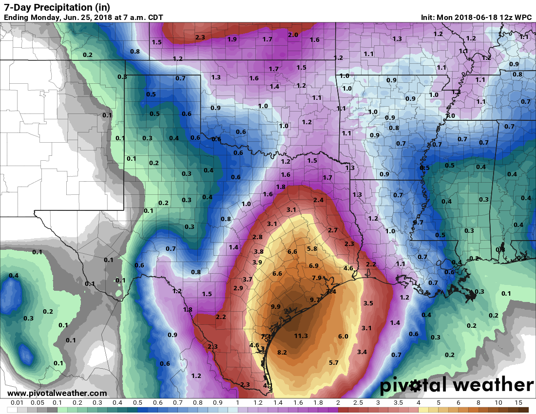
Periods of sporadically heavy rainfall will continue on Wednesday and Thursday, although at this time we don’t think storms will be nearly so widespread as on Monday and Tuesday. Due to the nature of these storms, we think street flooding will remain a possibility, but again we are not particularly concerned about bayous backing up. True, overall rainfall accumulations this week could be impressive for the region, with 6 to 8 inches of rainfall possible over a four- or five-day period. This is a lot of rain, but provided it comes over a few days as we anticipate, it remains well within the capability of the region’s bayou system to handle.
Friday and the weekend.
Up until this tropical moisture threat, the story of this month had been heat. The average temperature of 85.5 degrees at Bush Intercontinental Airport through Saturday put this month on pace for a top-five warm June, but highs in the 80s over the next few days will sap the sizzle from Space City.
Temperatures this weekend should remain relatively “pleasant” for this time of year, with highs in the low 90s, partly sunny skies, and chances for scattered showers during the afternoon hours. For Houston, this is about as good as it gets in late June, a somewhat happy medium between baking hot and torrential rainfall.
Just remember guys it comes down to inches per hour. Eight inches of rain over four days isn’t a problem if it is spread out. Seventeen inches in four hours like during Harvey is a BIG problem.
Everyday the rainfall totals change. Tropical Storm Allison stayed with us for days, which this disturbance seems to be doing. Will it cause as much flooding as Allison did?
No. Not even close.
I was expecting thunderstorms overnight, but didn’t even hear a rumble. Did that miss us, or is it coming later?
What do you foresee happening in the New Braunfels area Wednesday and Thurs? Will it be constant rain or sporadic? Trying to salvage outdoor vacation plans…
NWS has once again increased the total accumulated rainfall expected from this event in my area (Champions). The forecast has gone from 3.75″, down to 1.75″, up to 3.75″ and now it’s around 8″. Also, initially this event was expected to begin on Saturday and end today. Actually, it sort of started yesterday but now the main event is expected to start Monday afternoon and stretch into Thursday.
The forecasting accuracy has been poor and the level of forecast uncertainty is very high. NWS needs to make this clear to people. Here’s the latest NWS forecast discussion:
https://forecast.weather.gov/product.php?site=HGX&issuedby=HGX&product=AFD&format=CI&version=1&glossary=1
It’s not easy for a large and…ahem… taxpayer funded organization to admit that after spending millions of dollars on computers and mathematical models that they are reduced to guessing on this one. Either that or like so many young engineers coming out of college they just blindly look at what the print-out says instead of asking themselves if it makes sense or not.
…again, thank you for your work!
Tues – 11:00am
Some folks at ABC are ringing the alarm bells about potential flooding and increasing rain totals. Concern or hype?
If it is Channel 13 then it is usually hype. Not that the other stations are any better. It’s called scaring people into watching your newscast.
Thank you, thank you for your no-hype, informative and entertaining reports. Y’all have been my go-to since Harvey. Keep up the great work!
What is it about this system that is making it so difficult to forecast?
Afternoon. First, thank you for steady reporting- we appreciate it. Our area (SL/MC) is pretty dry so far- a few sprinkles here and there but by and large no accumulation of rain. I am wondering if most of the storm is elsewhere over Houston or going a totally different direction? Or, really my main concern, is it picking up moisture and hanging over the Gulf to dump on us big time later today or tomorrow etc? I know you guys post updates as they become relevant and imperative, so perhaps nothing “big” is happening right now? Just checking in. Again, thank you so much for what you post- it makes a very real difference to your “local” community.
You can look at this Texas radar:
http://www.corad.org/texas_radar.htm
Right now (3:45PM) most of the rain is hitting the Beaumont/Lake Charles area. Earlier today a lot of rain hit New Orleans. There is a lot of rain in the Gulf south of Houston. Will it spin into this area? I don’t know.
I talked to a coworker at our plant around Groves and they said they’ve already had about 4″ as of 4 PM. Another sucker-punch from Mother Nature, I guess.
Nope.
Don’t even mention the “l” word, last thing we need is a boiler trip.
Yes, same question here. We’re in the SL/Stafford area. So far this has been a non-event with very little rain.
My parents live in Port Arthur. Mom said their street had high water but no flooding in homes. Hoping it remains that way. They just moved back into their home a few months ago after rebuilding from Harvey.
Eric, it looks like it’s getting bigger and not moving out very quickly. Are you still not concerned? I look forward to your updates.
After watching the 10 pm news/weather, I wish you published an 11 pm rebuttal to all of their uncertainties and worrisome talk.