All I have is anecdotal evidence, but the mosquitoes in my neighborhood have been oppressive during the last week or so. I can only remember, on rare occasions, being bothered by mosquitoes during a morning or evening walk. But in recent days they have been biting me with vigor, including through clothing, even while moving. My experience is apparently not unique. So why are the bugs so bad?
It is difficult to generalize, as there are about four dozen different species of mosquitoes that live around the Houston area. And I am no pest expert or entomologist, but the recent activity seems to have been triggered by the wet spell we experienced during the last 10 days of November, followed by spring-like warmth during the first 10 days of December. This likely signaled the mosquitoes to hatch at an accelerated rate, as if we we were seeing spring rains. Regardless, it is miserable in parts of the Houston region. Fortunately, relief is coming.
Said relief will arrive later this week with the first of several cold fronts that appear likely to plunge our region back into winter-like conditions. The first front arrives Tuesday night, to push nighttime lows into the 40s. If you think that sounds cold, then wait until the week of Christmas. There are strong hints that our first freeze is coming then, and it may be rather persistent. More on this below.
Monday
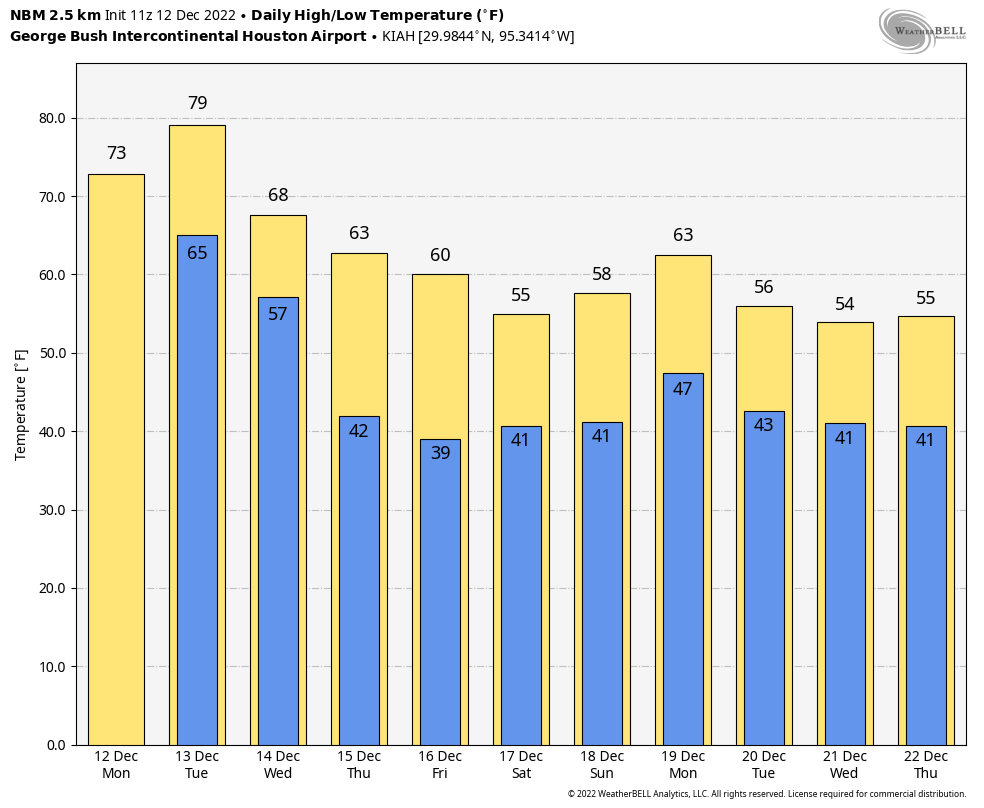
Before the cold weather arrives, however, Houston will see two more warm days. Today will be mostly cloudy, with highs likely topping out in the low- to mid-70s to go along with light southeasterly winds. As clouds continue to blanket the skies tonight, lows will only drop into the mid-60s. There will be a slight chance of rain late tonight as moisture levels increase along with the onshore flow.
Tuesday
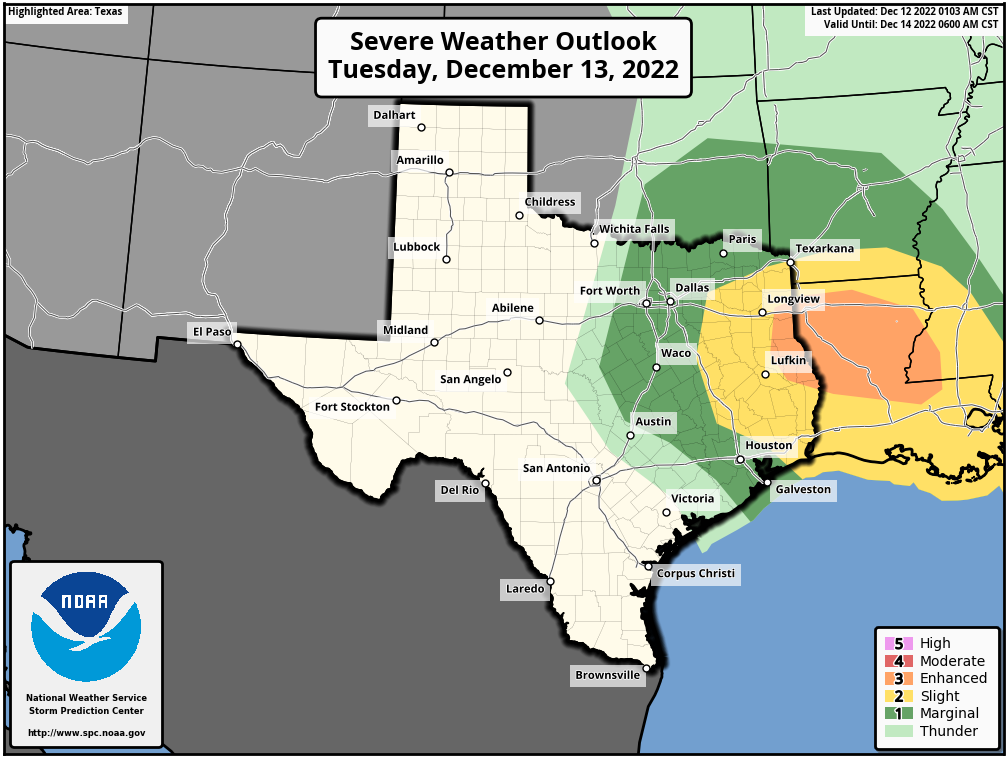
This will probably be the last really warm day of 2022. We can probably expect high temperatures in the upper 70s to 80 degrees ahead a cold front that will move in later on. Storms will be possible on Tuesday afternoon and early evening prior to the front’s passage, but the better dynamics for severe weather lie to the northeast of the metro area. Rain totals will be on the order of one-half inch in Houston, but there is the potential for higher, localized accumulations. As for timing of the front itself, along with drier air, it probably will make it into the metro area some time between sunset on Tuesday and midnight, before pushing off the coast a couple of hours later.
Wednesday
Skies will clear quickly after the front. Highs on Wednesday will likely top out in the low- to mid-60s, with sunshine and breezy conditions. Look for gusts out of the north at up to 25 or even 30 mph. Lows on Wednesday night should drop into the mid-40s in the city, with colder conditions for outlying areas.
Thursday and Friday
These look to be clear and cool days, with highs perhaps around 60 degrees, and lows in the low 40s. Welcome back, winter.
Saturday, Sunday, and Monday
First we’re going to see an additional front move in on Friday, to bring more cold air. Then, by Saturday, the upper atmosphere may become more conducive to rising air. This should generate some cloud cover and rainfall, although I’m not overly confident in the details. For now, Saturday through Monday will likely see partly to mostly cloudy skies, with high temperatures in the 50s, and a daily chance of rain in the 30 to 50 percent range. So this period has some potential to be dreary, but again, we’ll need a couple of days to fine tune the details. Overnight lows will drop to around 40 degrees.
Later next week
Most of next week looks fairly chilly, with highs probably mostly in the 50s. There is a fairly strong signal in the models for an even deeper burst of colder air toward the middle or latter half of next week. This could push overnight temperatures below freezing—perhaps even into the 20s—by around December 22 or so. This really is at the edge of our reliable forecasting capability, so it remains speculative. But my sense is that the days leading up to Christmas are going to be quite cold, and possibly the holiday itself. How cold? I’d love to be able to tell you that, but I can’t. However, I do think we’re looking at lows probably between 25 and 40 degrees, so you can expect Jack Frost to be nipping at your nose.
What about some of those models that indicate a possible snowstorm around Christmas?
Its too far ahead in time for any models to be legit right now.
Yeah, I mean, the latest GFS model appears to forecast -5 degrees in Baton Rouge Christmas morning. The previous one had it at 48 degrees.
Yeah, and the next model will probably forecast something different. Still 12 days away to know how cold it will be people
Knowing Houston, it will fall just to our north like the last few years. You’ll see 5″ of snow in Austin, college station, and huntsville, while we get very cold rain with perhaps the woodlands getting a few flurries.
Does the weather look ok for me to drive to Tyler Tx area in the morning stound 9:00
Assuming you are leaving Houston at 9 A.M. today, Monday, the weather should be fabulous for a drive to Tyler according to weather.com. I hope this helps.
No leaving Tuesday morning @ 9:00
I’m wondering if this frost/cold front warrant wrapping the plants, and when to do so. Any idea if it’s going to be necessary?
You should dig everything up and put them inside…forecast is for nothing to survive! We started uprooting our 50 year old oak trees today (32 of them) and put them in a warehouse in Spring.
Ready for the cold to blow through!!
Can’t remember the last time we had an actual cold Christmas
Didn’t it snow Christmas Eve 2005 or 2006?
That was fun.
2004.
2004!!
2017.
Given our cold week, warm week pattern we see a lot I’m scared to be optimistic about cold on Christmas. Will the cold really be able to hold on that long? I know that’s not how weather actually works, so I’m hoping so! Lol
Fleas are bad in my neighborhood, too.
Roaches in mine
Visited Florida for Thanksgiving and had the same issues with mosquitos. Was a bit surprised how ferocious they were, being it was December. I wonder if it has more to do with mitigation programs shutting down or reducing treatments as we head into winter?
I’m gonna guess that warmer temps coupled with increased precipitation hence water sources have enabled them to breed. Once we get a hard freeze in another week or so, they’ll be culled heavily along with many other more beneficial insects.
I have noticed before that mosquitoes seem bigger in the late fall than in summer.
Oh lord, hopefully Christmas won’t be freezing cold. Traveling during freezing condition to go along with the already terrible Houston drivers just makes for a nightmare.
As an ecologist, these increasingly wide extremes worry me. It means that plants have fewer defenses, animals have less time to avoid destructive temps… plant death means fewer food sources for animals, shrinking habitats. Not gonna lie, it’s getting scary.
A hard freeze with ice and snow for south Texas on Christmas Day ? Christmas eve of 2004 with the eight inch snow all over again ?
When do I start freaking out about my pipes freezing? While mine were fine, several condos in my complex had burst pipes. Can the grid keep up or will this be another Uri?
During last freeze my well head actually froze solid and burst all pipes to well also. Do I need to worry again? Please let me know it was a nightmare going 2 weeks without water….