Monday’s high temperature reached 94 degrees in Houston, a remarkably warm day for this time of year, and breaking a record set in 2007. Fortunately a cool front—not a particularly strong front, but a front all the same—is pushing through Houston this morning and will bring us a short reprieve from the summer-like heat.
Tuesday
Winds have shifted to the northwest this morning, and drier, cooler air should filter into the region today. As this air moves down, it may collide with very moist air along the coast to produce some showers and thunderstorms. Areas that do see rain probably will receive a tenth or two, and showers should be short lived. Otherwise, expect highs around 80 degrees under partly to mostly cloudy skies.
Tuesday night/Wednesday morning
I’m posting this special section for the runners, and for the people who want a taste of fall. The period of driest air, with dewpoints falling into the 50s for most of the area, should come only relatively briefly, between about 10pm Tuesday night, and 10am Wednesday morning.
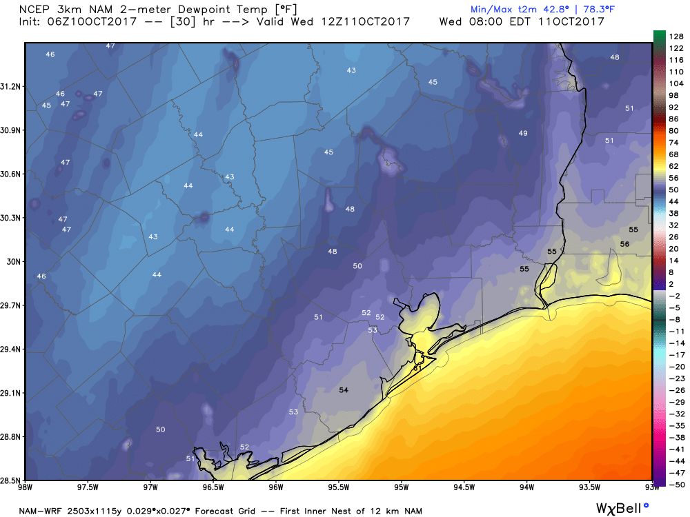
If you’ve been waiting for some weather to make an extended run, this is it. (I’ll be getting up at 4:30am on Wednesday, and if tomorrow morning’s weather report is delayed an hour or two, this is why).

Wednesday
Should be a pretty nice “fall” day, with partly cloudy skies, a high of around 80 degrees, and an overnight low in the upper 50s for far inland areas, mid-60s for most of Houston, and warmer closer to the coast.
Thursday through Saturday
High pressure returns, and along with it humidity, warmer temperatures, and mostly sunny skies. Look for highs in the upper 80s to 90 degrees, lows around 70 degrees, and only isolated showers. Summer returns, more or less.
Sunday and Monday
The warmer weather should continue, with high temperatures near 90 degrees. However, rain chances should tick up slightly as another cold front approaches, and possibly moves through the area some time on Monday-ish. It’s still too early to say how strong this front will be—the models are mixed—but I have some decent hopes that it will be stronger than the one currently moving through. We’re watching closely, as we are just as desperate for fall as you are.
Enjoy your run! I know I will!!! Thanks for the info, as usual:)
Thanks for the somewhat good news, Eric. Hopefully a cool fall will come soon. What is your take on further activity that may affect the Gulf? It’s pretty quiet in the Atlantic and Gulf right now minus Ophelia which will not affect us. Should we expect any further systems that may affect the gulf?
So looking at historical temps we are on a collision course to have the exact same “fall” we had last year and the previous year with 80’s in December and an 83 degree Christmas day.
Bite your tongue, Ryan! Last year also gave us the one nasty cold snap that wiped out most of our fruit trees. Of course I know that “past performance is not an indication of future results”, but with the extremes of weather we’ve seen in the US this year, I’m ever more nervous about those wild swings in temperature.
Stepping outside this morning and feeling that first taste of cooler air gave me life!
“If you’ve been waiting for some weather to make an extended run, this is it. I’ll be getting up at 4:30am on Wednesday, and if tomorrow morning’s weather report is delayed an hour or two, this is why)”
Man, you are one dedicated runner — enjoy the “not from Hell” running weather while it lasts!
It was reasonably nice this morning. just dry enough (for me) for a long distance run.