Good morning, everyone. I’m back from Spring Break and ready for whatever Mother Nature is going to throw at us in the weeks and months ahead. In the near term, that means more beautiful weather today, and the potential for storms and heavy rain on Monday and Tuesday. To account for possible street flooding, we are issuing a Stage 1 Flood Alert for areas along and north of Interstate 10 from noon Monday through noon Tuesday.
Sunday
After a drop-dead gorgeous Saturday, today will be similarly nice with highs in the mid-70s, ample sunshine, and plenty of dry air. One difference you’ll notice is that winds will become southerly later this afternoon, perhaps gusting to 15 to 20 mph. This will start the influx of moisture that will increase the potential for storms on Monday and Tuesday. Lows on Sunday night will only drop to around 60 degrees, as clouds move in.
Monday and Tuesday
Monday morning will warm, gray, and humid, with the possibility of some light showers across the area. However, winds will continue to build out of the south and southeast, perhaps gusting to 35 or even 40 during the daytime. These winds will be in response to an advancing low pressure system and cold front. This system will combine with the increasing moisture levels to produce a favorable environment for showers and thunderstorms, some possibly severe, during the afternoon and evening hours. Some hail, damaging wind gusts, and even tornadoes are possible in Houston, especially away from the coast.
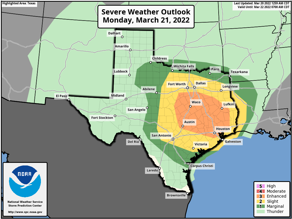
This severe storm threat will persist into Monday night, but at some point the potential for hail and tornadoes will diminish. However, as that’s happening, by early Tuesday, we should see increasing potential for heavy rainfall as the front itself nears. I think, overall, most locations can probably expect 1 to 4 inches of rain with higher isolated totals. It has been so dry that such rain totals are manageable, but as usual we can probably expect some street flooding on Tuesday in hard hit spots. The potential for heavy rain is greatest for inland areas, so we’re issuing a Stage 1 Flood Alert for Houston locations along and north of Interstate 10.

The front itself probably should push into central Houston around noon on Tuesday, or few hours earlier. This should end the threat of inclement weather. Lows will drop into the 40s for most areas on Tuesday night as cooler air moves in.
Wednesday and beyond
Things clear out and cool down with the arrival of a front on Tuesday, and this will lead to mostly sunny and pleasant spring-like weather for the rest of the week. More details on this tomorrow.
Enjoy the rest of your weekend!
KHOU is forecasting 70+ mph winds Monday for Houston. Is this possible or just typical sensationalism?
KHOU is on some kinda spice – Boba Fett reference, lol – as they often are. Vividly recall in lead up to Arctic Blast when Blake Mathews was predicting “white out” and “blizzard like” conditions in downtown Houston! I’m sticking with you lads!
70 mph? I mean, really?
Yipes. Well, I certainly look forward to trying to drive to work at 4:45 am on Tuesday. 🙁
We’re wanting to fish out of Galveston Tuesday afternoon. I’m wondering if it will be cleared out by then.
Is it safe yet to say whether we’re done with freezes for this year until autumn?
Any chance of school being canceled? 😂
ugh, I just took my plants out.. I took them out of the greenhouse because I thought we’re done with freezes… Now I have to worry about wind and hail? Mother Nature, ya killin me!
Hoping to catch a flight out to MEM at 8 hoping things have settled before storm?