A few readers may have heard some thunderstorms as a weak cool front moved down into the Houston region this morning. These storms are fairly isolated, and should move southward as the front pushes off the coast after sunrise, later this morning. This will bring a brief reprieve from Wednesday’s heat and humidity, but for truly fall-like conditions we’ll need to wait for a stronger front to arrive on Monday. This one should bring glorious weather, as well as a nice dose of much-needed rainfall with it.
Thursday
High temperatures today will reach about 90 degrees, and it will take some time for the drier air to work into the region following the frontal passage. With the front stalling near the coast, high resolution models are showing the potential for some additional showers and thunderstorms to fire up this afternoon and early evening over Houston. I expect them to be fairly scattered, however. As drier air moves in, expect lows tonight to drop into the 60s for Houston, and showers to end.
Friday
Don’t blink, otherwise you’re going to miss the front’s impact on our humidity. That’s because dewpoints are expected to only briefly bottom out on Friday morning before humidity levels start to rise again. Friday should see mostly sunny skies, with highs in the upper 80s and light winds turning southeast. As this more moist flow resumes, lows on Friday night should be a few degrees warmer than Thursday night.
Saturday
The first half of the weekend looks sunny and warm, with high temperatures near 90 degrees. Humidity will be back, in abundance. Enjoy your last day of full-on summer, you diehards.
Sunday
The atmosphere will start to become a bit more perturbed by Sunday, as a disturbance or two passes over the region, ahead of the next front. So while Sunday morning should be partly sunny and warm, there will be an increasing chance of showers and thunderstorms later in the day, and overnight. Look for highs in the mid- to upper-80s depending on cloud cover and rainfall at your location.
Monday
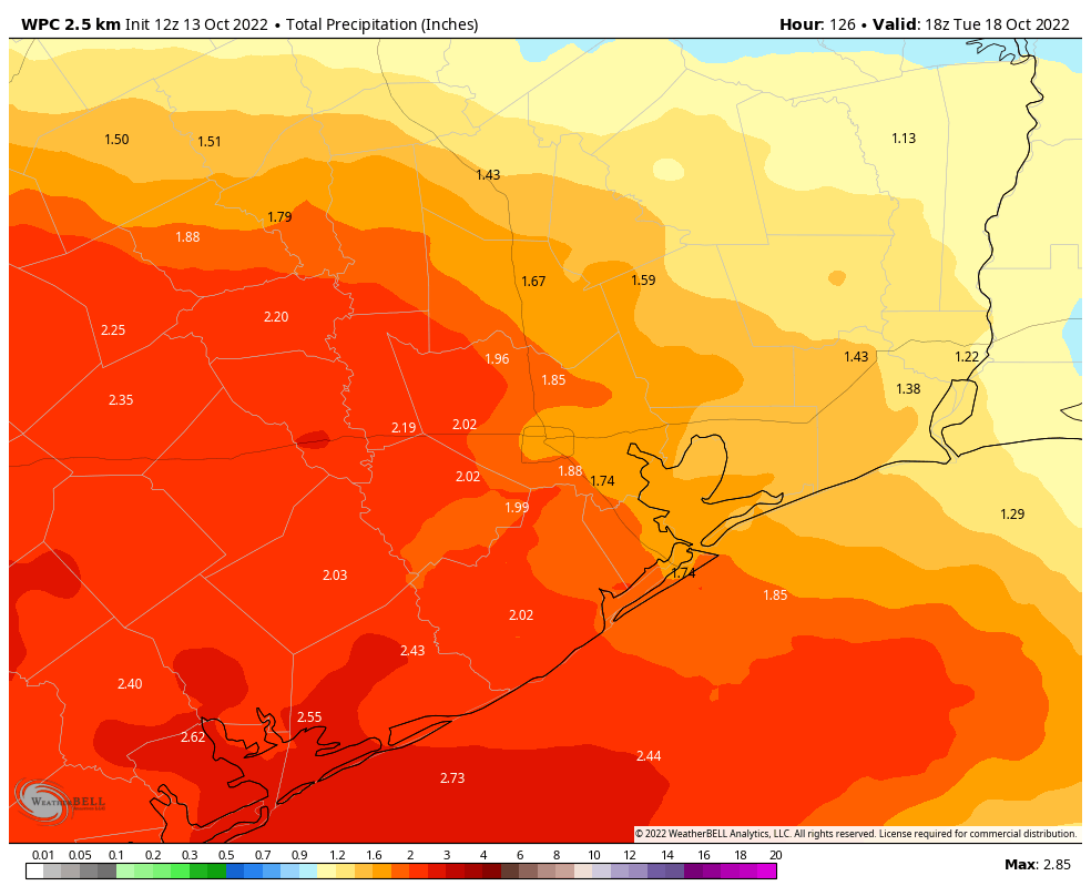
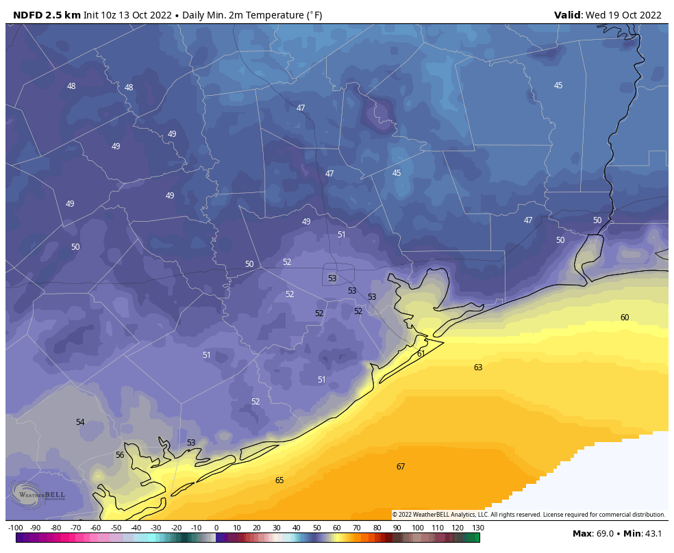
Cold front day! A stronger front should move through Houston on Monday, and this will also support the best chance of rainfall. Much of the area should see 1 to 2 inches of rainfall through Monday night, but as usual some parts of Houston will get more, and others less. Highs on Monday may only reach the upper 70s, depending on the timing of the front, and how far away from the coast you live. Lows on Monday night will probably drop into the upper 50s for most areas away from the immediate coast, but again this depends on the timing of the front.
Next week
As for the rest of next week, well, it looks pretty freaking great. I’m expecting at least a few days with highs in the 70s and lows in the 50s (for Houston) and 40s for areas further inland. Fall is here, baby, and it’s going to be spectacular.


I had several drops of “rain” on my windshield this morning.
Shall I evacuate to Katy?
Yea, we had a Texas 8 inch rainfall here. 8 inches between drops!
Love your humor
Also love your humor…much needed along with the rain on Monday and COLD FRONT!!! Woo-hoo!!!
A few minutes ago, my neighborhood near Gulfgate Mall received for at least 4 minutes or is still receiving a light sprinkle. I finished my barefoot raises in front of the kitchen window by the kitchen sink and then walked away.
Your post today begins my day with a smile- your word choices and the message they deliver have me feeling good about living on the Gulf Coast. After a week in the hills of East Tennessee- sweater weather and Fall colors- I needed that. Thank you!
Color me jealous …would love to see the fall color, the leaves changing …so pretty
The sky spit on me for a few minutes while navigating the Gulf Freeway inbound a little before 7 AM – just enough to remind me I need new wipers. Also some impressive lightning NE of the house, maybe Baytownish.
Hurried in from early morning walk under darkening skies, growing thunder-boomers, and now enjoying morning beverage listening to heavy rain. Rain. At. Last.
Pasadena got a pretty good shower this morning
Getting nice thunder boomers here in the NASA area this morning.
Eric- I think you mean spooktacular.
Tomorrow could you predict the weather at PNC stadium for Sunday at 4pm? Houston Dash, the pro women’s soccer team, will play their first ever playoff game. Record attendance expected.
I did my part to trigger that rain overnight: I washed my car yesterday.
Pouring rain in San Leon this morning. We sure needed it!
While I was generally upset to already be awake at 4am this morning, I was elated to be able to hear it start raining in my corner of Katy at that time. Light rain for a little while, but it was over and done by 5 o’clock, Katy Mills area.
No rain in Timbergrove and man, it was some kind of humid on the dog walk at 6 a.m., but suddenly started to feel drier by 630 when we got home…and, lows possibly in the 50s next week? That seems a bit early, but I’m not complaining!
One month ago Karl would have been heading this way but since this cold front is pushing Karl south, you see why the end of September is usually the end of hurricane season for us.
It was pouring around 0710 on Beltway 8 by Pasadena going towards Gulf Freeway. Enough to slow down traffic considerably. Was not expecting that at all lol.
As others have said, love the humor. I am beyond excited for some real Fall weather in Houston.
They’re real and yes, they are SPECTACULAR!!
Got lucky this morning with the rainfall south of League City. 2.77 inches.
81% of the US in drought or abnormally dry now.
And all the models are trending drier next week here.
3/4″ in Clear Lake this morning!!!
Definitely some welcome news! Did get a nice 2/3 of an inch of rain this morning here in Dickinson. Certainly could use more.
8:28 in Pearland – it has been raining cats ‘n dogs for 15 mins or so, these are no small drops or drizzle
Why, oh why, am I always in a Hole here at Durham and “Wash”ington Ave? Oops, Stop! Skip! Go Around Random House. Pick up again on (pick a direction) side…
GD Urban Heat Island! Cemented to death, deforested? What gives? Please Advise, I am soliciting theories.