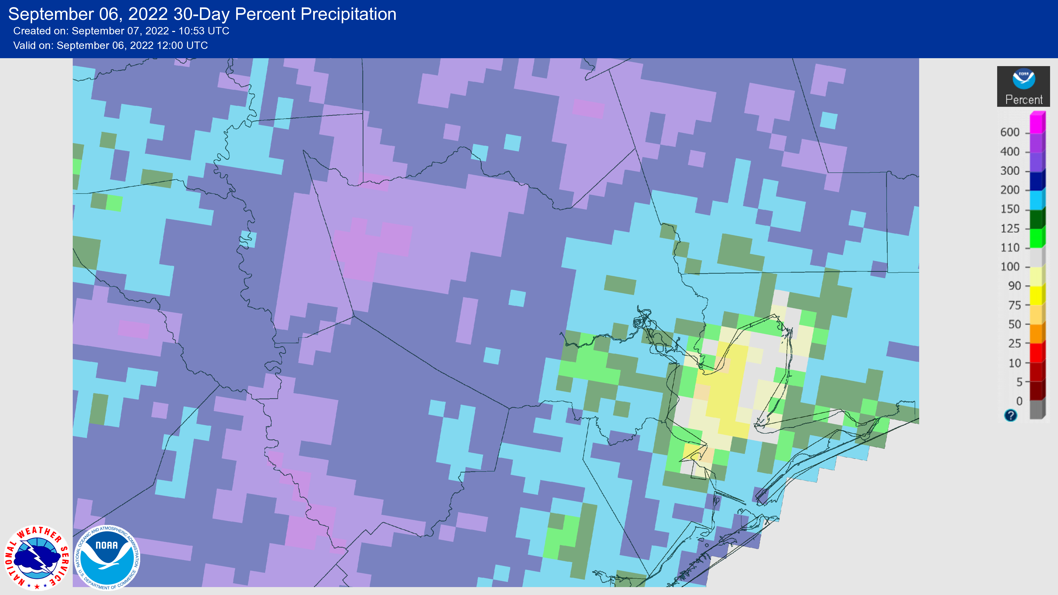
After a very dry spring and start to summer, August brought beneficial rains to the entire region. Parts of the Houston metro area, particularly in Brazoria and Galveston counties, remain in a moderate drought as of this writing, but we have come a long way over the last 30 days. This is especially true as August is typically our hottest and potentially driest month, so we just got through the worst time of year for drought. If you’re wondering how your area stacks up, the map below shows “percent of normal” rainfall for the 30 days preceding September 6. Pretty much the entire western half of the metro area received 200 percent or more of normal rainfall, with most of the eastern half recording 125 to 200 percent.
All good things must come to an end, however, and after today the next two weeks look fairly dry. This does not necessarily signal that we’re going to enter into a prolonged dry spell, but it does mean the frequent rainfall we’ve seen in recent weeks should now subside.
Wednesday
Houston will have another shot at rainfall today, however. I’d peg chances at about 40 percent as an upper-atmospheric disturbance helps generate lift. Look for showers to start out up north later today and then drop down toward the metro area. None of these storms look severe, but you could see a briefly heavy shower. Rain chances fall back this evening. Otherwise expect partly to mostly sunny skies, with high temperatures generally in the low 90s.
Thursday and Friday
These days should see lower rain chances as the disturbance moves away from the area. Call it a 20 percent chance for each day, with mostly sunny skies. We’ll also see winds veer to come more out of the east-northeast, and this should moderate temperatures slightly so that we see highs of around 90 degrees. Overnight lows should drop into the low 70s for Houston, with cooler conditions further inland, and mid- to upper-70s near the coast. This won’t be great, but it won’t be terrible either.
Saturday and Sunday
Expect more of the same this weekend, with sunny skies and about a 20 percent chance of daily showers. Highs will be in the low 90s, with nights generally in the 70s.
Next week
We’re still looking at the potential for a front to make it through early next week, and at this point I think it’s likely that something will push into Houston and off the coast on Monday. Please set your expectations accordingly, as this front is probably not going to bring significantly cooler air. But for a day or two we may see some drier air, which should make mornings and evenings feel somewhat—dare I say it?—kind of almost pleasant? Look for highs of 90 degrees for most of next week with low rain chances.
Tropics
There’s a lot going on right now, but over at least the next week or so there is very little of concern for the United States. This is an amazing place to be as we approach the absolute peak of hurricane season on September 10.


I haven’t had to water the lawn or landscaping for almost all of August. That really is unheard of. And, with the Harris County rain gauge near the house showing a 30-day total of 8 inches? I’m not going to turn the hose on for another week or 10 days. Glorious. And, yeah, I’ve “moderated” my expectations about the “front”. A couple cooler mornings walking the dog will be nice
This year we didn’t have our usual Ughust. However we did have Jugh and Julugh.
huh?!
Incredibly poor attempt at humor, that’s what it was
The rain has me behind with everything, it will take me a while to get caught up mowing grass and working on other outdoor tasks. The city has been a mud pie. I like the hot sunny weather. Who doesn’t enjoy seeing the girls in summer clothes.
Come on jason we’re on a public forum here lol
I truly hope we will be in a less rainy stormy pattern for a prolonged time, more than two weeks..I’m about to plan a trip to Colorado, to stay a week..Then it’s back to Houston..I’m tentatively planning for this trip to happen in a time window of the first week or two of October..I want to avoid weather related cancellations/ground stops if possible ..Although it’s impossible to know if it will be storming on my travel days, I would love to find out a if there’s a prediction/educated guess regarding general wet or dry weather pattern beyond these next two weeks..
Would this front count as a “cold front” after which our chances of getting hit by a hurricane drop down to almost zero?
or is it still too early for that?
Not likely. This won’t pack enough punch to provide steering for approaching tropical systems away from the coast.
Probably too early for that
so no stormy weather at all?
We are getting wrecked here in the Memorial area.
Sadly since we are fixing to enter a La Nina fall, we will probably be seeing drought conditions make a comeback within the next few months.
I really dont care for ‘cold fronts’, the temperature now is fine. I’m more worried about not getting any rain again. Having another dry month after this rain. Hopefully not! We need steady days of rain every now and then.