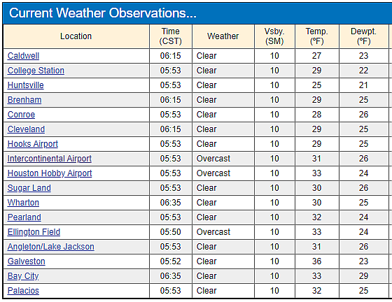
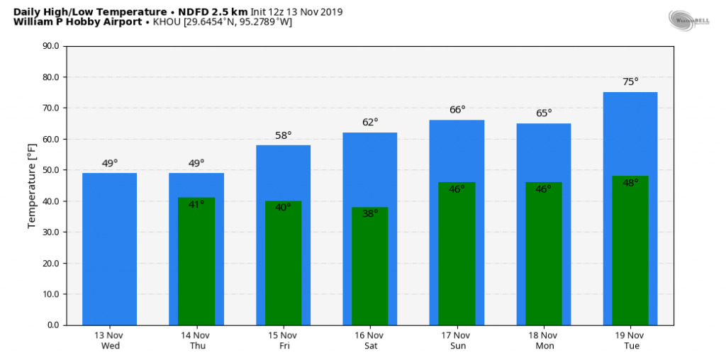
An Arctic front has brought a widespread freeze to Houston, with temperatures generally in the mid-20s to mid-30s this morning across the region. This will be the last of the freezing weather for us, for now, but we’re going to remain in what passes for “winter-like” conditions in Houston through Saturday. Next week looks to be warmer, on the whole.
Wednesday
As the next front approaches from the west, it will begin to push rain chances up later today. A relatively dry atmosphere should keep Houston mostly dry into this afternoon, but by this evening or the overnight hours we can probably expect to see the development of light showers across much of the region moving in from the southwest. Highs today will struggle to reach 50 degrees as clouds build across the area, with lows tonight falling to around 40.
Thursday
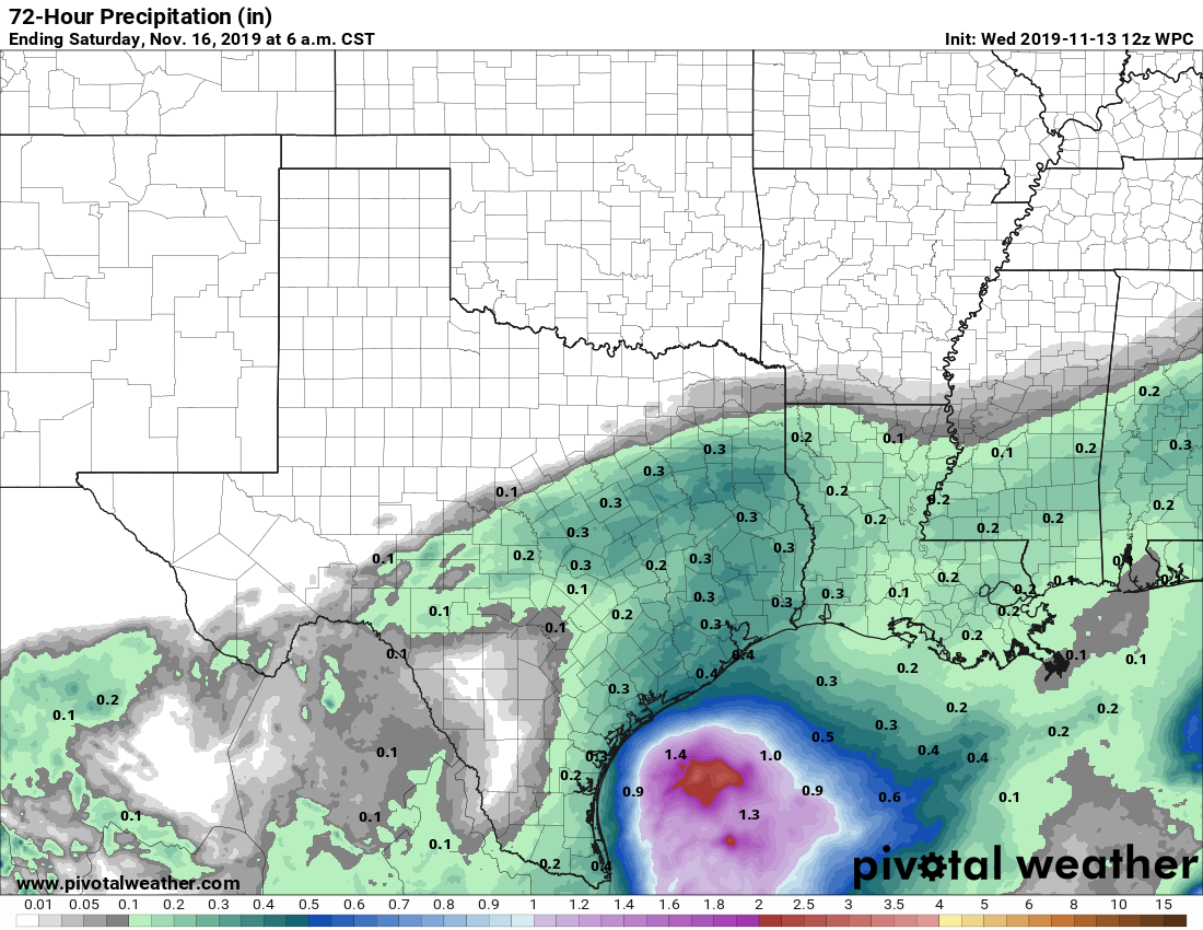
This will be a gloomy day, with cloudy skies, and on-and-off light to moderate rain showers. In terms of accumulation, most of the region will probably see on the order of 0.25 to 0.5 inches of rain from Wednesday evening through Thursday, so this is not something to be concerned about in terms of flooding. The absence of any sunshine should limit temperatures to the upper 40s for most. The rains should end some time Thursday evening for most as the front pushes through and dries out the atmosphere.

Friday and Saturday
These both look like a pair of splendid days, with highs of around 60 degrees, mostly sunny skies, and clear, cold nights. Friday night should be the coldest with lows reaching the upper 30s for parts of Houston; Saturday night will be several degrees warmer.
Sunday and Monday
Just as the onshore flow kicks into gear, another front will approach on Sunday. This will introduce the possibility of some light rain later on Sunday—highs will be in the upper 60s, most likely, with partly sunny skies—and during the overnight hours. Monday should be sunny, with highs in the 60s.
Later next week
After this we’ll see a warming trend next week, with daytime highs generally in the 70s, and overnight lows in the 50s and 60s. It’s not clear when the region’s next strong cold front will arrive. Speaking of very cold weather …
Sponsor note from Reliant
Winters in Texas can be unexpectedly chilly, so Reliant is here to share seasonal energy saving tips for your electricity bill. These simple home improvement tasks can keep your heating system from working harder than it needs to and keep you from spending more than you want to on winter electricity bills.
Home winter prep tips and projects:
- Get regular tune-ups for your HVAC system — twice annually if possible. Spring and fall are good times to have a technician check and ensure your system is running at its best.
- Seal air leaks. Common places for leaks include windows, doors, attics and basements. Add weatherstripping around doors and caulking around windows to seal leaks. This helps keep indoor air in and outdoor air out.
- Check your thermostat settings. For every degree above 68°, you can expect a 3% to 5% increase in your heating costs.
- Clean your fireplace and apply caulk around fireplaces to seal leaks. Maintaining your fireplace will help cut energy costs.
- Close blinds at night for an extra layer of insulation on windows. Open when the sun is shining to let the heat from the sun warm the room.
- Get a Nest programmable thermostat. This can help you reduce energy usage by up to 15% without lifting a finger.
- Set the fan to rotate clockwise during winter to push warmer air down.
Visit Reliant.com for more information on common causes of high winter bills, tips for staying warm without spending more and free energy-saving tools.
At last! A bona fide cold spell with some staying power. I love it!
Looking at the table of this morning’s lows, I noticed all stations report clear except the three airports reported overcast. What gives?
IAH, HOU, and EFD are all augmented reports, which I believe means there is a person helping out the automated observation. All the rest are automated, the sensor is limited to cloud heights of 12K’, thus won’t report anything higher than that.
Knew about airport designation but not about 12K/850mb heights. Thanks. Great info 👍
Those are also the only airports in the area whose control towers are manned 24/7. The others on his table (a total of 5 additional have control towers) usually open up at 0700.
Guessing you’re in the aviation field in some way😀
You are correct Monty. While I can’t “officially” use this website as my aviation weather source, it is where I turn to every day for an outlook.
Pretty good place to turn for sure. Do you use NWS or a private source?
Thank you Mike.
You’re welcome!
At least we were not turned into white walkers.
Not a weather comment but I have always wondered how the Reliant Spokes-Armadillo gets his t-shirt on under his shell. 😊 Thanks – love your site and the great forecast info!