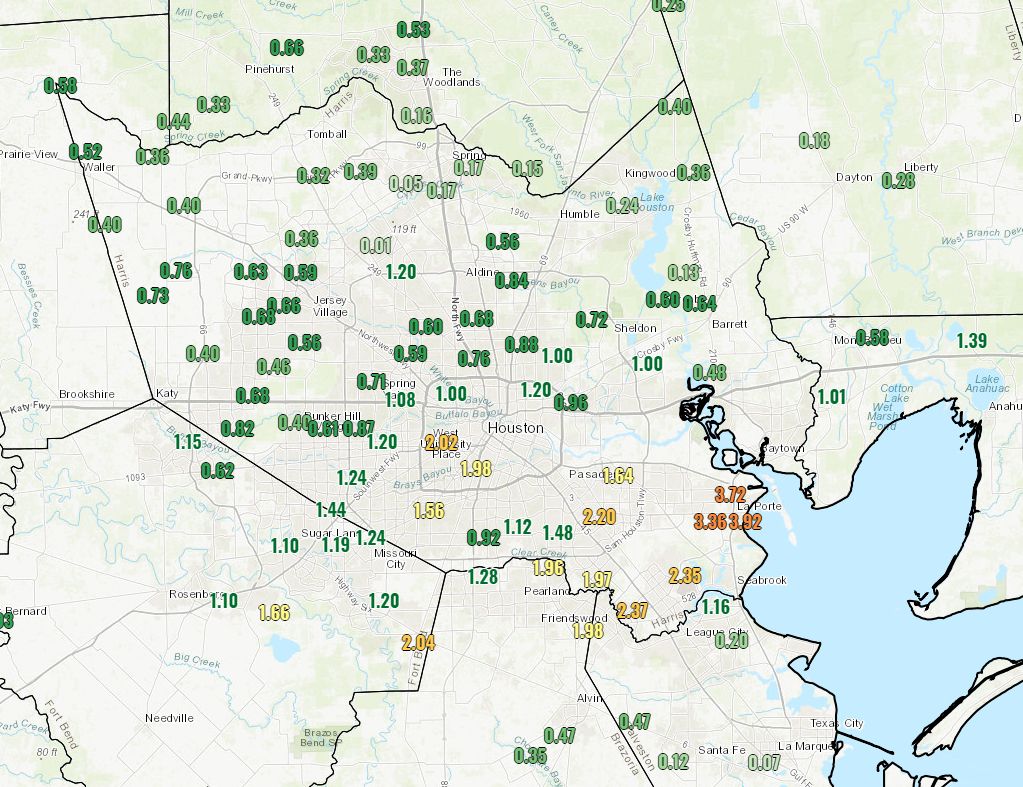
Storms on Tuesday afternoon and evening proved more intense than anticipated, with some areas near Rosenberg, West University Place, Pearland, Friendswood, and Clear Lake seeing 2 inches of rain or more, and Deer Park and La Porte seeing 3 to 4 inches of rain. Fortunately, this threat of heavier rain appears to have passed—although daily precipitation chances are likely to remain with us through Sunday. It’s a messy forecast, so let’s jump into it.
Wednesday
The main problem this morning is fog, as warm air in the 60s moves over cooler water. A dense fog advisory is in effect until 10am this morning so take some extra care for your commute, or trips around town. Today will be fairly warm, with highs in the mid-70s under mostly cloudy skies. We probably will see some scattered showers develop this afternoon, although I don’t expect them to be nearly so organized or as intense as those on Tuesday evening.
Rodeo forecast
 Temperatures will still be in the low 70s at around 6pm today, and we cannot rule out some showers over the central Houston region. I’d put the chances of light rain near NRG Stadium at about 30 percent going into the show. Conditions will still be muggy after the concert, but rain chances should fall down to around 10 percent.
Thursday
The will-it or won’t-it make it cold front appears likely to stall somewhere over the Houston metro area on Thursday. Of this much, we can be sure: a cold front will push into the northern edges of the metro area on Thursday morning. After this, the most likely scenario is that the front stalls somewhere along Highway 59, or perhaps a bit closer to the coast. Your local temperature, humidity, and rain chances are all going to vary Thursday depending on how far the front makes it (for example, the range of possibilities for afternoon temperatures at Bush Intercontinental Airport in the European ensemble model range from the upper 50s to 75 degrees). So our official forecast is ¯\_(ツ)_/¯.

Friday
Depending on the extent of the front, some areas of Houston will see some sunshine on Friday, and temperatures will probably get into the 70s. Rain chances look fairly low, but non-zero (20 percent).
Saturday, Sunday, and beyond
A stronger front is coming this weekend, but it’s not clear whether it will arrive Saturday evening, Saturday night, or Sunday. (We’re really helpful today, huh?) We can be pretty confident that Saturday will be a warm, gray, humid day for Houston with highs in the range of the upper 70s with lots of humidity. Of course we’ll also see some healthy rain chances (50 percent) but I’m not seeing anything right now to suggest any severe weather.

Sunday’s temperatures will depend on the timing of the front and, whenever it blows through, it will be significantly colder. A reinforcing front blows through on Monday, or so, and after that we could finally see a stretch of clear (yes, sunshine) and cold weather for most of next week. I’m thinking highs in the 50s or low 60s, and probably a good 40 percent chance of a freeze for areas such as The Woodlands and points north.
We had 3.6” in our gauge in West University.
i got unexpectedly stranded in quickly rising high water on bissonnet @ weslayan…so much water everywhere. 🙁
I would like to understand why rain predictions are not accurate. Logic would indicate that besides the use of radar and models, that one could monitor the amount of rain that has already fallen as the storm system moves over each area and more accurately estimate the amount rain. If it’s dropping 2-4 inches in its path…..you see where I’m going with this…
So, clearly I have faulty logic because predictions have a tendency to be off. I usually double them to get to reality.
Anytime I ask this question, I get the standard “that’s why we say higher amounts in thunderstorms”. (I’ve asked WPC)
But that response doesn’t provide a technical reason.
You willing to provide a technical response?
Because it’s Mother Nature.Who can 100% accurately predict that to a -T-?
Showers sometimes pop up right on top of you. Have you ever seen that? I’ve seen it plenty of times on the golf course. Showers also sometimes dissipate before they reach you–which is nice if you’re golfing.
Some good answers here already. I will just add that the computer models used to predict thunderstorms do not have a high enough resolution (i.e. cubic pixel) to entirely model the atmospheric physics inside individual storm systems. With current (and near future) modeling, you’re simply not going to get perfectly accurate rainfall predictions.
The second factor, when it comes to Houston and the entire Gulf Coast, is a warm climate near a warm body of water that is capable of producing downpours. Sometimes all of the ingredients are there for heavy rain, and it doesn’t materialize, sometimes it does.
Thanks all…I wasn’t complaining and I know it can’t be perfect, just interested in technical aspect of process since I’ve seen so many predictions be way off. And they can make or break a decision to evacuate or not.
I realize this week isn’t that type of event, just thought I’d ask before it gets to that season.
Someone got up on the wrong side of the bed this morning.
Guys, I’ve had nearly 4″ of rain at my place the last two days (1,3″ Monday and 2.6″ Tuesday). Think you could back off on the rain a little? My back yard is turning to mud. Thanks!
3.10″ of rain and 1004 lightning strikes at my house in Friendswood. No hail though, whew!
Arianda,
If you spend some time reading back through posts on this weather blog, you will discover a clearer conversation about weather than on any other public site or show. There are better explanations, presentations of the different models and how they play together or why significant or insignificant, and also clearer and more accurate predictions. As a consumer and a weather junkie, Space City Weather has been a great resource and help.
You might skim back through it like a book to see what you think of their predictions and the comments. Is interesting to read backwards from hindsight.
Am interested in your question, if a better (technical) answer is given – but my throw it out there hypothesis is that one cannot make a “perfectly accurate” prediction on matters like exact rainfall in a system before it moves across a path because there are so many interactive variables at play at every single moment. Air temp and ground temp, wind speed, pressure, etc.
I wonder if we will ever have enough technology to perfectly read and predict the entirety of the weather as it unfolds? It is so dynamic. But am grateful for what we have! Cannot imagine revisiting Harvey (or any of our major storms) if it had come from “out of the blue” like the hurricane of history that destroyed Galveston.
Katherine
I will have to go back and read to know for sure. I wasn’t aware of this site until well after Harvey.
What I am aware of is that NOAA and government officials knew well in advance that Harvey was going to be bad, but shot down social media that tried to warn us until they deemed it time to tell us.
That said. I’ve been faithfully following Space City Weather once I learned of it and have been satisfied and appreciative of Greg and Matt’s efforts!
I don’t envy you guys… The Houston metropolitan area is very large.
For example: Conroe to Galveston is approximately 90 miles. That is ONLY 10 miles less than the distance between Philadelphia, PA and Baltimore, MD!! (which is also about the same distance from Philly to NYC, or Chicago to Milwaukee)
Katy to Mont Belvieu is approximately 60 miles. Which is actually farther than the distance between Boston, MA and Providence, RI.
So cut them some slack when it comes to forecasting our regional weather. Houston’s location in a very active weather zone – our southern backyard is the sometimes scary weather factory that is the Gulf of Mexico, and we’re located just south of Tornado Alley! Weather forecasting here is a challenge.
Maybe I’m oriented differently because I’m not a native Texan, but I always thought of the Gulf of Mexico as our “front yard” and the rest of Texas, including up to Tornado Alley as our “backyard” a hurr hurrm.
With the next reinforcing cold front early next week, are we out of winter ? Hope the kids have some spring in spring break!!
Great question — but can’t say for sure.
We had 4” in our rain gauge this morning. It was a fun storm!
Just wondering about rainfall in Fort Bend County this Saturday. We’re getting married at 2PM with the reception right after. Should we expect rain the entire time?
Congratulations! No, I would not anticipate rain the whole time. Still uncertain, but the best guess is intermittent light (misty?) rain. Maybe just gray and humid.