Good morning. The story of the summer so far remains one of heat, and while we’re going to take a step back in temperatures for a few days, the reprieve may be relatively brief. In case you’re wondering, Houston now has an average temperature of 88.5 degrees for the month of July, which would break the existing record of 87.5 degrees (set in 1980) by a full degree. June, already, was the city’s warmest month on record. I’d like to say this summer sucks, but the opposite is actually true in regard to the pressure pattern driving this heat.
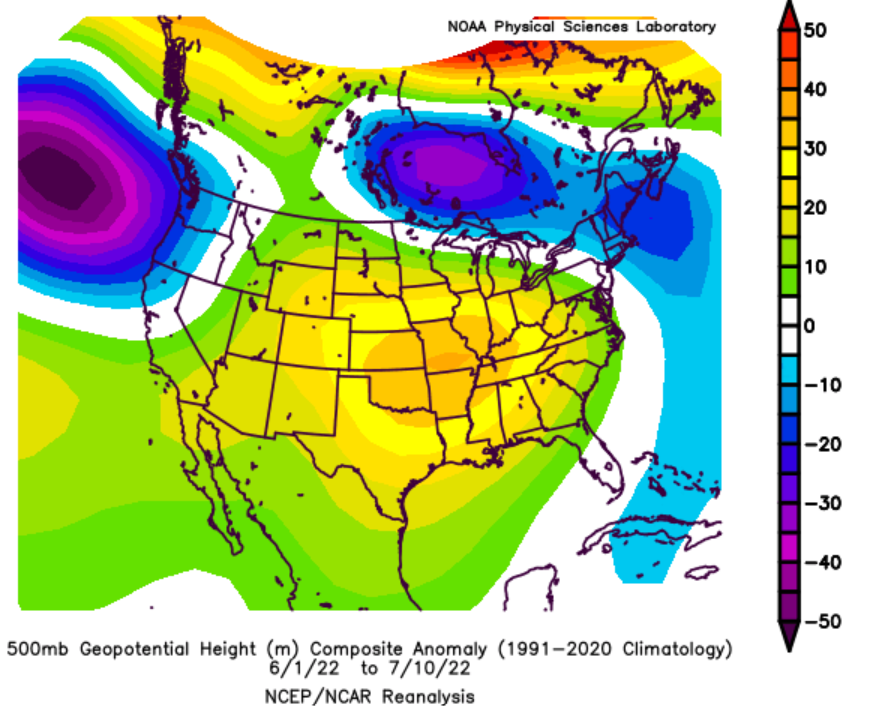
Persistent high pressure over the southern United States has been the predominant meteorological cause of this summer’s heat. This has generally created conditions for sinking air, which has led to clear skies and sunny days. This provides ideal conditions for daytime heating, and outside of one week in late June and early July, we just haven’t had much of a break from this pattern. Unfortunately, we expect the high pressure pattern to mostly persist at least for the next couple of weeks.
Wednesday
Happy 713 day! It’s July 13, the day we celebrate Houston’s OG area code and our city’s unique identity. Hopefully, Mother Nature will get into the festivities and keep highs just below 100 degrees for at least part of the city. Highs will range from the low 90s along the coast to the low 100s for areas well inland, as the region experiences yet another brutally hot day. Like on recent afternoons, we should see some scattered showers and thunderstorms pop up north of Houston, and then move steadily toward the southwest. Some areas west of downtown got lucky yesterday, and I wish you good fortune today. Watching the radar of late has been a mix of hope and dread—hope for rainfall, and dread of the inevitable miss.
Thursday
This still looks like the day with the best chance for more clouds, widespread rain, and somewhat cooler temperatures. This is because the high pressure system retreats a bit further to the west, opening the door to rain chances of perhaps 30 to 50 percent, and keeping highs in the mid-90s for much of the area.
Friday
Another day with highs possibly only in the mid-90s, although rain chances look to be lower than Thursday.
Saturday and Sunday
Alas, high pressure will start to build back over the region by late this week, and both weekend days look very hot, in the upper 90s to 100 degrees with mostly sunny skies. Rain chances, again, look to be quite low, perhaps 10 to 20 percent.
Next week
The outlook for next week still looks a little muddled. Generally I’d expect highs in the upper-90s, but I think there’s a chance we’re a bit cooler than that, with some slightly better rain chances. Put another way, it’s going to be hot, but I don’t think it’s going to be quite as brutal as it has been as we’ve seen so far this month.
Eric won’t say it but I will: This summer well and truly sucks.
Agreed!
Eric, I know this isn’t a climate change blog, but can you help me understand how high pressure and climate change are related? Your blogs have been saying that the cause of this summer’s record heat is high pressure. How is this related to CO2 concentration? Is it that without the CO2 we might be 1-1.5 degC cooler? That would make the average for the month 86 – 87 degF instead of 88.5. We would then be a little bit under the 1980 record.
Silly question … when we say “dome of high pressure” is that pressure being exerted from underneath that dome shape, or from above? TIA.
I see the pressure anomaly chart. But NOLA seems to get a lot more rain than Houston. It is under the same sinking air scenario. Why is Houston so dry?
Very good observation DJ!
I am interested in seeing an explanation for this also.
Mostly because NOLA tends to be more on the periphery of the U.S. high pressure ridge most commonly, even if the anomaly puts them in a similar regime as Houston. So less subsidence, less capping, enhanced opportunity for precip. Also, they’ve been the recipient of eastern Gulf origin precip systems that just haven’t made their way west to us.
The high blocks tropical systems and they get nudged northeast toward Louisiana
In the dog days of summer when I was a kid I recall my grandparents would say, “well it’s summer, it’s its season for hot weather”. Made sense to me then, makes sense to me now.
We used to get a respite from this heat by getting long drawn out showers or straight thunderstorms. A good thunderstorm would come with a 20 degree drop in heat at least temporarily. My oh my how I miss those days. I thought that higher temperatures in the Gulf meant stronger storms making landfall. I guess that’s wrong?
Eric/Matt: Is there a time of year when the high pressure ridge begins to break down instead of wobbling around to the east/west? I would think this might coincide with the timing of peak hurricane season in mid-August to mid-October.
Thanks!
Right now, the mid-latitude jet is shifted well to our north and is of lower amplitude. This location is due, in part, to it being summer as well as effects of continued La Nina. Normally we tend to be more under the influence of the Bermuda high in the summer, which its contraction/expansion will help steer/guide tropical systems in this region. Not until closer to fall would you expect the North American southern jet to shift back southward a bit and start gaining amplitude.
You promised us acrostics until the heat broke. I feel cheatd.
When Eric wrote for The Houston Chronicle, there was a period of time when he wrote Haiku at the beginning of his column and it cracked me up. I’d like to see Haiku reintroduced if only temporarily.
More like this summer compresses…like a vise.
Wildfire concern now. I’m interested in what the U.S. Drought Monitor shows tomorrow. Just trying to keep my trees alive. I think I’ve lost a pine. (grass is toast)
I’m gonna need you and the fam to do a rain dance! Please!