In brief: We discuss heavy rainfall north of Houston, and lesser accumulations in Houston. After this morning we’ll see a reprieve from showers, but starting Tuesday or Wednesday we’ll see decent chances for the remainder of the week. The weekend should see clearing skies and warmer temperatures, so the early beach outlook is favorable.
The boundary that produced significant rainfall overnight is exiting the area, but it has done its damage in terms of heavy rainfall to the north of Houston. Two areas, one from College Station to Madisonville, and another northeast of Huntsville, recorded 10 inches of rainfall during the last 24 hours. Some rivers and bayous in this area are likely to reach a moderate flood stage over the next day or so.
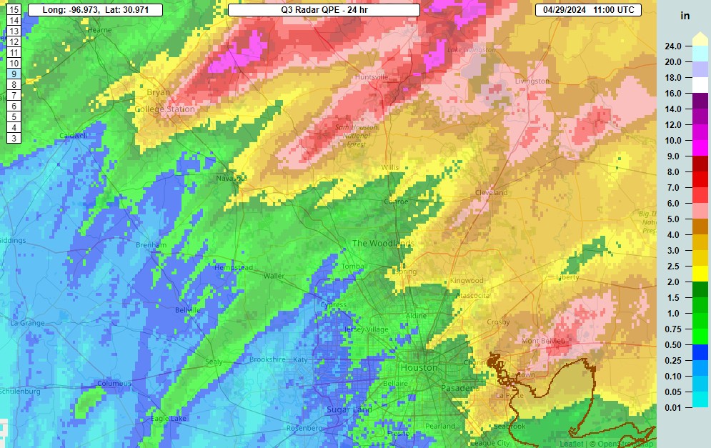
Closer to Houston, the high-water mark came near Baytown and Mont Belvieu, with a few areas recording 5 to 7 inches. Rainfall amounts were widely variable, as some areas of just west of Houston picked up less than half an inch. But all in all it was a wet night. Too wet for some areas, with ongoing flooding occurring north of Houston, but still some much-needed rain for most locations. The remainder of spring should be nice and green in our region.
Monday
The line of storms has moved well to the east of Houston this morning, but we’re seeing some lingering showers, and these could continue for coastal areas through the morning hours. Later today we’ll see clearing skies, and this is likely to be our best chance for guaranteed sunshine this week, at least until the weekend. One welcome change this morning is much lighter winds, which will blow today from the east-southeast at 5 to 10 mph. Highs will reach into the mid-80s, with a few locations popping into the upper-80s depending on sunshine. Rain chances remain low this evening and overnight, with temperatures dropping to around 70 degrees in Houston.
Tuesday and Wednesday
The overall pattern remains unsettled this week, with the absence of a strong high pressure system. As a result we’ll see continued decent rain chances, on the order of 30 percent daily. I don’t expect anything too organized, and for the most part these should be scattered, garden-variety showers. Highs both days will be in the low- to mid-80s with mostly cloudy skies. Nights will be warm, in the low 70s.
Thursday and Friday
We’ll see a continued partly to mostly cloudy pattern to end the work week, but rain chances will inch up a bit. Again, I’m not expecting a deluge, but daily rain chances will likely be on the order of 40 to 50 percent. Accumulations should be greatest north of Houston. Look for highs in the mid-80s, depending on how much sunshine breaks through during the afternoon hours. Southerly winds will pick up a bit toward the end of the week, with some gusts of 20 or 25 mph possible.
Saturday and Sunday
Rain chances should diminish some this weekend, with a corresponding increase in sunshine. We’ll still see some clouds, but there probably will be more blue skies, and there appears to be only a slight chance of rain at this point. Look for highs in the 80s, perhaps upper 80s, with plenty of humidity to spare. All in all, a good pool or beach weekend for early May.
Next week
Could we see our first temperatures in the 90s next week? Quite possibly. The first full week of May looks fairly sunny, and fairly warm. We could see the onset of summer lite in Houston if current trends hold.

Yikes! Our lights are still out in Baytown from the storm.
Went to bed last night thinking that my neighborhood missed another rain event entirely.
Well, the good news is we got 3.5″ – along with maybe 15 seconds of hail, which off course woke me up.
The bad news is the power went off and on at least half a dozen times. When it comes back on, the whole house reboots, waking me up. Then around 4:15 the phone goes off for a tornado warning expiring at 4:30 and I don’t even live in the warning zone.
This will definitely be a 2X caffeine morning at the office.
I slept thru another storm! its crazy how we continue to be in this midnight storm pattern. at least down here in the Hobby area.
Those lightning cracks right outside the house last night were shocking 👀
I lost power in Montrose around 4 am, but luckily it was short lived. Man, those white noise machines coming back on is what woke me, and not the thunder. Crazy! I’m glad I watered my plants on Saturday. You’re welcome. 😉
Is the atmospheric setup that’s coming for the weekend of May 4th going to be similar to what led to last night’s event?
probably gets discussed on Wed/Thurs
I’m beginning to think it’s the altiplano. A lot of influence on our weather and perhaps drags on the south end of fronts during daylight (hot) hours. Maybe the pattern in years past was not a southerly wind across it. A few have commented on why always storms at night and not day in last few years.
I think it could be a mixture of that and just the timing of which these boundaries reach our area. Historically these cold fronts and the outflow boundaries associated with them seem to reach our region during the overnight hours more often than during the day especially during the spring.
Hahahaha trying to help out Wayne D and Rinkos. I personally recall these kinds of fronts rolling thru downtown during the day and admittedly it does seem awhile since we’ve seen that. Maybe some different oscillation – not ENSO – causing this. Where else can you kick around amateur weather talk but right here on SCW!
Agreed this is a great place for amateur weather talk. Yes it has been a while since we had a front bring storms during the day. I wish we could get a storm during the day again. I love Nightime storms but I also would like to see a heavy storm during the day again. Other than January, we have been in a more La Nina ish pattern this year. There is likely some other oscillation event steering things at the moment. That is why I don’t like to put a whole lot of faith in the black and white predictions of El Nino and La Nina because many other factors also influence the jet streams.
Does anyone actually enjoy the weather here? I am so sick of it I could scream. Hot, humid, rainy. I can’t take it anymore. So glad I am moving this fall.
Just for the record, it’s entirely likely that most of the people to whom you have continually ranted about Houston’s weather since you arrived are also glad you are leaving. Houston’s weather is just what it is.