In brief: The good news is that the worst of the wind is over. We will still see strongish south-southeasterly winds today, but the gusts will be lower than on Saturday. And winds will certainly be much calmer on Monday. However, before that the region faces a decent chance of storms, including severe thunderstorms, particularly during the overnight hours.
At present there is a line of storms essentially along the Interstate 35 corridor. This system will move eastward today, but it will do so in fits and starts. And truth be told there is a lot of uncertainty about the impact of these storms due to a capping inversion, and how long it takes to break. (A capping inversion prevents warm air at the surface from rising, an essential element in the development of thunderstorms).
My best guess for what happens is that the greater Houston area sees scattered showers during the daytime today, with a few isolated thunderstorms. Nothing too impactful. Highs will reach the mid-80s with mostly cloudy skies. Beginning later this afternoon locations such as College Station and Conroe will see a better chance of thunderstorms. During the late evening hours, which is to say probably a couple of hours before midnight, a larger mass of showers will develop to the north of Houston and then sag southward toward the coast, and eastward toward Beaumont. They’re likely to exit the Houston area by sunrise on Monday.
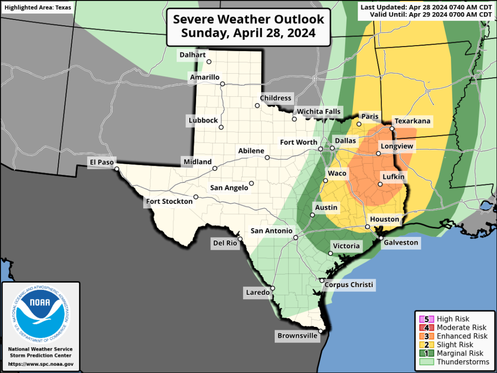
We’ll see the usual threats with these storms: heavy rainfall, damaging winds, and the potential for a few tornadoes. The threat for severe weather is greater for inland areas, where the capping inversion looks weaker, than it is the coast. But all of the area will have the chance to see some thunderstorms later tonight. In terms of rainfall, I expect totals to vary widely. Some areas may pick up as much as 3 inches or more, but most of the area probably receives 0.5 to 1.5 inch. A few coastal locations may remain dry. There’s big boom-bust energy tonight.
Monday should be warm, but mostly rain-free.

Do we have an excitable dogs scale for tonight?
Hahaha! Maybe it’s gonna rain 😃
Weather is hard.
We always seem to be under a “cap”. Rain aficionados actually get a kick in the gut when reading that. Often due to the altiplano mexicano ….but winds have been SSE all weekend. Is the warm gulf doing this?
The winds have been out of the SSE over our region, but over in the Southwest portion of Texas they have been more southerly. This is what helps filter in that cap of dry warm air from the Mexican Plateau. This is more towards the mid levels of the atmosphere. The cap can be right over us even when the surface winds are still blowing directly out of the gulf. Through most of this spring, these mid latitude cyclones have been skirting over the panhandle of Texas. These northward lows tend to pull in that dry capped air from the Plateau because of the way winds blow towards the center of these lows in a counterclockwise motion. We have a much better chance of getting widespread rain when these mid latitude cyclones track over the mid and southern half of Texas. Theoretically if the land of Mexico didn’t exist and was just ocean, I think we would get much more rain annually here in Southeast Texas.
Btw the “Cap” doesn’t always prevent us from getting rain. Often times the warm humid rising air can break through this cap. This is when severe storms and supercells can flare up because the updraft builds alot of extra momentum while being held down by the cap inversion. It’s like forcing your way through a locked door. It takes alot more force to break open the door when it is locked versus when it’s unlocked. Your going to have much more momentum when the door breaks open. Not the best analogy but it’s all I could come up with at the moment lol
I see it now on the 850 mb (5000 ft) wind chart
Ok good. That’s helpful
When is the first brave meteorologist going to stand up and tell the unknowing public that these storms are man-made?!! I am angry that the evil ones ‘in charge’ are so intent on instilling fear and death on us.
Please google mental health resources for your city. You do not have to live in fear like this. There are people who can help.
Snigger! 🙂
Your comment has been deleted. Please be more civilized in the future.
It is difficult to provide any weather forecast these days for a huge concrete disaster like Houston. However, city government is getting it’s jollies with their Growth, Growth, mantra and to hell with the environment.
Its a bit too late to complain about Houstons infastructure since this has been going on for a long time now Ken
Glad I don’t depend on any ‘forcast’ 100%. Some areas got 8-9 “inches.and
Flash flooding as this is written.