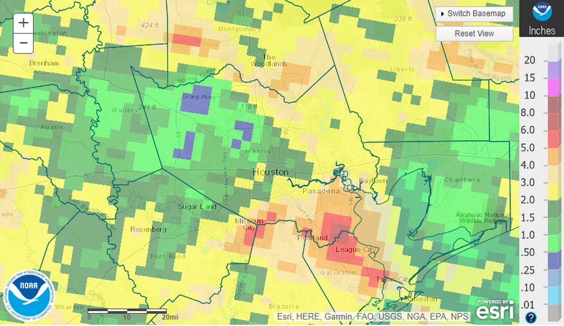
Before jumping into the forecast, let’s review the widespread rains the region experienced over the last several days. The map below displays rainfall total estimates for the previous week across the metro area. As always there is a broad variation in the precipitation over such a broad area, with some areas receiving as little as 0.25 inch, and others near Clear Lake more than 6 inches. But pretty much everyone received at a least a modest soaking during the Thursday through Saturday period.
The window for widespread rainfall will now close for awhile, with only a smattering of afternoon chances later this week. Overall, the forecast looks to be fairly boring, with mostly sunny skies and high temperatures generally in the low 90s. It will, essentially, be weather typical for late summer in Houston. This is the time of year when we can realistically start looking to mid-range models to see if any significant fronts are on the horizon. Alas, I just checked. There are not.
Monday
Drier air is moving into the region, and we’re going to bottom out with dew points in the 50s this afternoon. That will make our highs in the low 90s feel a bit more comfortable. Skies will be mostly sunny today with light easterly winds. Temperatures this evening should be fairly pleasant, about 80 degrees, with slightly slower humidity. Outdoor plans would be a good thing. Lows tonight will reach their lowest this week, probably, with low 70s in the city. Some lucky inland locations will see the upper 60s tonight.
Tuesday
We’ll have one more day with slightly drier air, but the onshore flow is headed back on Tuesday, so humidity levels will only be a stitch below normal levels. Highs, again, should be in the low 90s, with mostly sunny skies. Winds will turn southeasterly. Lows on Tuesday night will be a couple of degrees warmer than Monday night.
Wednesday through Friday
As high pressure takes control of our weather, we can expect to see highs in the low 90s, sunny skies, and warm nights in the mid-70s. But the ridge won’t be so strong as to preclude a 20 or 30 percent chance of afternoon or evening showers, along with the sea breeze.
Saturday and Sunday
The late week pattern should more or less persist through the weekend. The last gasp of a dying front will approach the region on Sunday, and this may bring a bump in rain chances, but I don’t have much confidence in how that will ultimately play out at this point.
Next week
At this point I’d bet on next week’s weather being similar to this week’s—there’s just not a whole lot of change in the near-term forecast.
Tropics
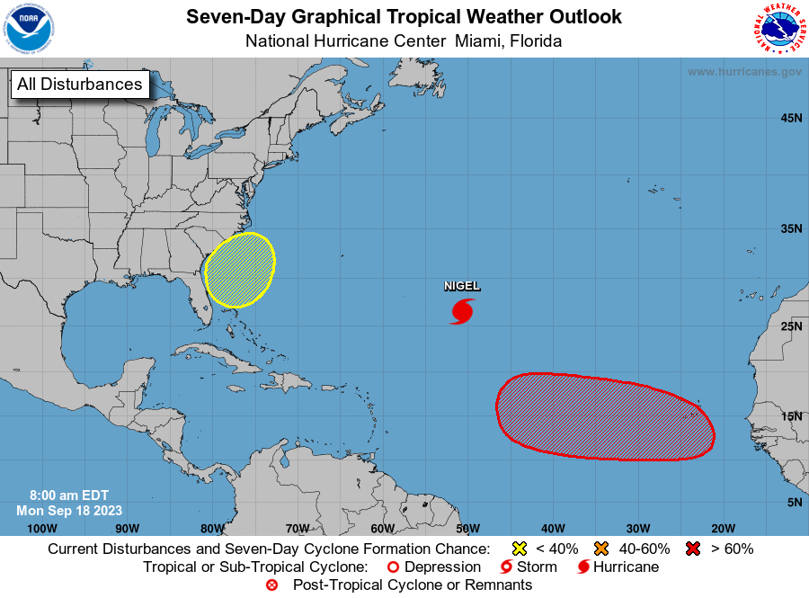
The Atlantic tropics continue to sizzle with activity, with Hurricane Nigel following behind the now dissipated Hurricane Lee, and potentially more storms on the way. Fortunately Nigel does not appear to be a threat to land. Moreover, the Gulf of Mexico continues to look exceptionally quiet for at least the next week. Head over to The Eyewall for a full rundown on the tropics today, and every day.


We’re in a strange bubble near 610 and 45 and received less than 1/8” over the entire ‘rain’ period. Heartbroken.
There were definitely pockets of the westside that struck out on rain fall. I’m near SH6 in between Katy and Cypress and haven’t gotten more than 0.05” since July.
We’ve gotten plenty of the associated wind from the storms – enough to knock down tree limbs, but no real precipitation. Sad.
It looks like everybody got rain but me. I live near the intersection of Louetta and Grant, and barely got enough to wet the streets. Guess I better change my ways.
I also live near Louetta and Grant and I figure one of the neighbors must have angered the rain gods. Almost nothing in the rain gauge since early July.
Down the street at Grant and Cypresswood. I’ve started cursing Mother Nature out loud. I have no respect for her right now.
this is not nature’s fault, that area has been getting its forests cleared constantly to make way for crops/housing and people have been cutting trees left and right, moisture just doesnt evaporate there. It’s a desert. Human’s fault.
We got 3.5″ of rain over less than an hour, majority of it happening in less than half-an-hour. It was an amazing amount of rainfall so quickly. A gentle soaking would have been better, but I’m thankful for any non-flooding amount of rain.
“Autumn carries more gold in its pocket than all the other seasons.” ― Jim Bishop
Just a few more days until the autumnal equinox. This year in Houston it occurs at 2:55 AM Saturday morning. The temperature may not feel like fall but after this summer it will be comforting knowing we survived the summer from hell…
Yes, just wish we had some cooler temperatures. It feels like it’s never gonna be cold again…
I got almost an inch of rain on Saturday (out in the Klein area by Hooks Airport) and was so happy – I was worried I was also going to be caught in one of those bubbles that the rain seems to keep going around and around and around….
When I checked the National Hurricane site I did not see the yellow blob off the east coast or the red blob in the central Atlantic. Are those still being tracked?
Sounds like some nice weather. Fortunately no mention of any hurricane threat to Houston, and it is getting near the time when the chance of a hurricane hitting Houston really dwindles.
Really hoping we won’t have to be making plans for Nigel…
I see what you did there 🤘🏻
Would have been even better if a wx nerd had taken the bait. Eclectic group here
My birthday is in around 10 days. Seems like the temps are always in the 90s and annoyingly hot or 70s and perfect. Looks like I’m getting a sweaty party.
Some folks look at the weather models for hurricane tracking. This time of year, I look for cold fronts. The 12z GFS shows a low of 55 degrees on October 4th. May be the first cold front, but that may be as accurate as long range hurricane models, but at least it’s in the long range model now!
Interesting from that graphic above, we’re in the 1.5-2″ section but the Harris County gauge has us at 0.76″ during the same window, so I’m curious if NOAA did some sort of amalgamated average for the area.
2 1/2″‘ rain near Westchase over the weekend.
We got no more than a tenth of an inch in Deerfield Village. 3 days in a row the storms skipped over us. And the next two weeks look like more summer drought weather!! Help!