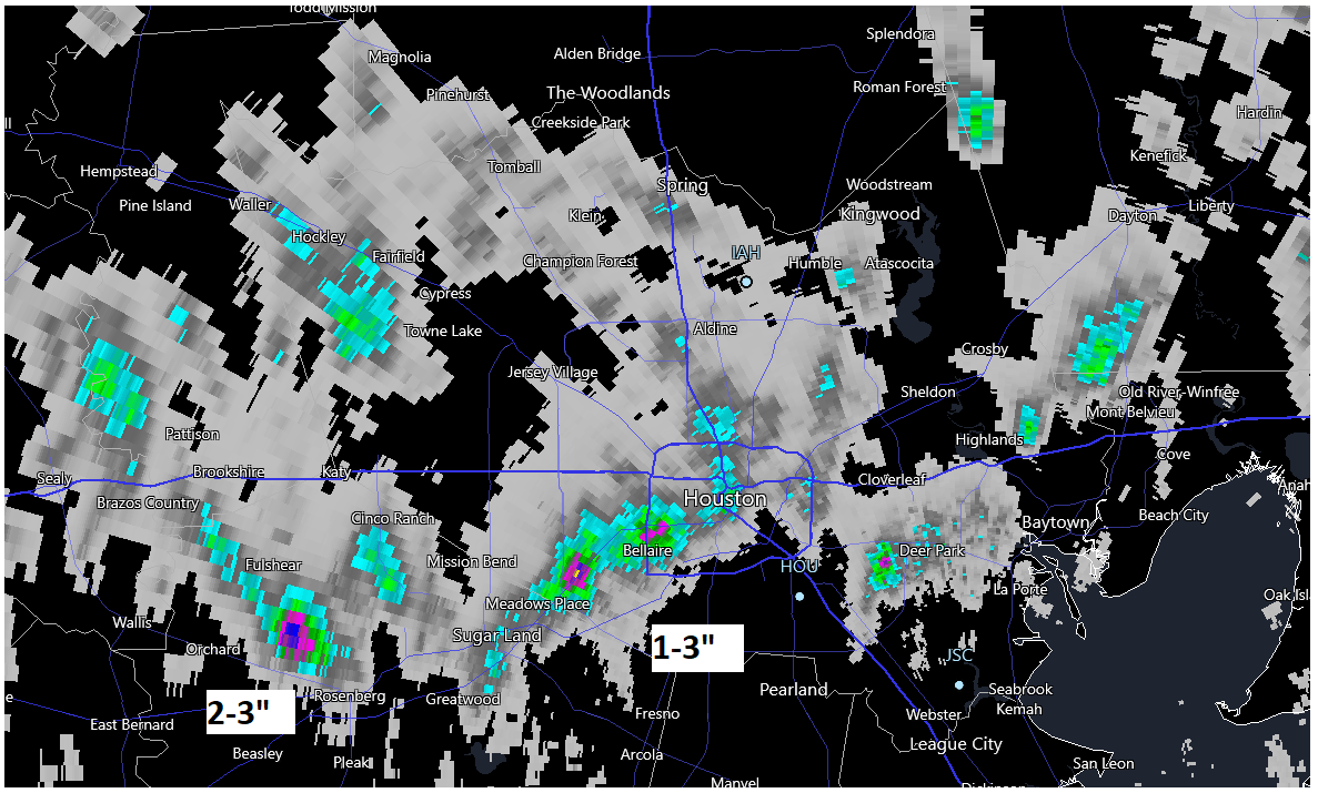
Yesterday was Thirsty Thursday in parts of the Houston area. While the coverage of showers and storms was a bit less than Wednesday, some pretty heavy rain fell in spots, even leading to some street flooding. On the map below, the teal color is generally about an inch, green is an inch and a half, and pink/blue starts ratcheting up to 2 to 3 inches. Obviously, the hardest hit areas yesterday were in parts of Fort Bend County, Sharpstown, Bellaire, West U, and close to Pasadena.
We remain in drought, however. In fact, as of Tuesday, extreme drought had expanded to cover half of the Houston region.
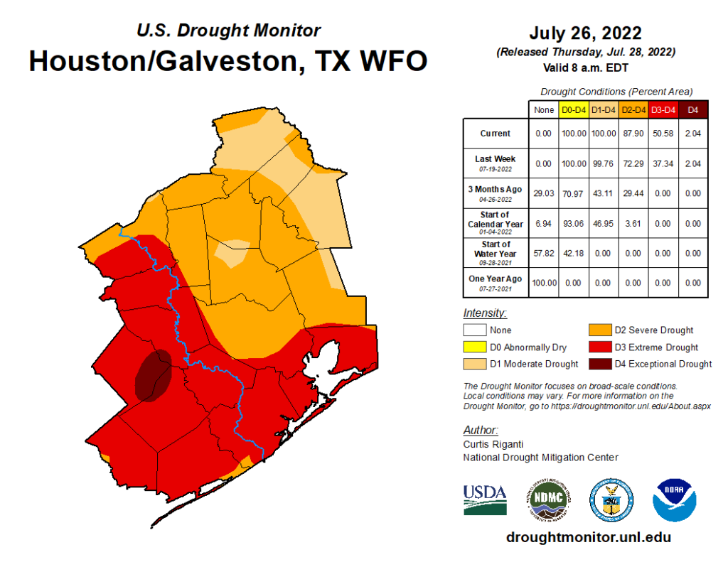
These showers aren’t heavy enough over a wide enough area to really seriously dent the drought, but they offer considerable short-term relief. Hopefully we can get some more.
Today
Coverage of showers should be similar to more extensive than Thursday. We have a little extra help today coming courtesy of a little disturbance moving west across the Gulf. Like yesterday, generally slow moving showers could lead to a quick inch or two or even a bit more in spots. Plenty of places won’t see rain today. Outside of the storms, mid to upper-90s once more.
Weekend
I do think we’ll see a noticeable decrease in shower coverage this weekend. We’re sort of at the mercy of exactly how an upper level system tracks, currently expected to pass offshore far enough to sort of “rob” what’s needed for showers. A few places could see an isolated storm or two, especially on Sunday. Additionally, look for some haze, courtesy of Saharan dust. Mid to upper-90s should dominate for highs, with 70s for lows.
Next week
Rain chances should bounce back a little bit on Monday again, before diminishing Tuesday and perhaps Wednesday and Thursday as high pressure settles in overhead.
By the end of the week, there are a few more questions. With high pressure expected to anchor in North Texas, Oklahoma, or Kansas this should keep us hot and humid, but it may be just far enough away to keep the door cracked each day for shower and storm chances. More on that next week.
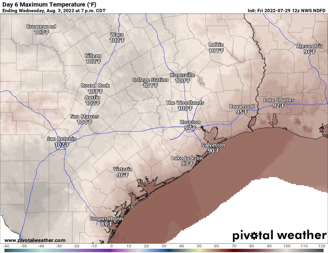
The heat will be with us though with mid to upper-90s each day. We’ll have a couple shots at 100+ here or there too, but I’d expect to see more 98s and 99s. Does it matter? Not really, but it’s something I guess. More Monday!
Not a drop of rain all week in my part of League City. 🙁 Hoping maybe to get some today. Could really use it.
Here in the northern desert, we haven’t had measurable rain since the end of May. (Just north of 99, between the Woodlands and Porter)
Every single storm either dies before getting to us, or misses us by a few miles. It is getting almost comical.
We live in northeast Tomball just south of the woodlands and have joked for years that someone operates a weather machine in our area. Storms always dissipate before reaching us, or they break apart and reform after passing us. It’s time they turn it off, though, because we really need the rain.
Good morning!
I really enjoy your weather forcasts and information
I have a question – Have you heard about the Fairfield Bubble?
I live in the Fairfield subdivision in Cypress and it seems that when a storm is approaching the area it splits or moves away one direction or the other
It is an elevated part of Harris County due to a salt dome under the area.
Looking at the Topographic map, Fairfield sits at about 195ft. Hockley is at 230ft. Cypress lakes is at 160ft. There’s nothing about 30-40ft of elevation especially if it is gradual that will steer storms away. en-gb dot topographic-map dot com slash maps slash lroh slash Texas
Nothing here since May with the exception of two brief showers. One in June and one the beginning of July. The critters are desperate for water. As are the trees and other vegetation. Great year to learn to garden!
I live under the umbrella over Northwest Harris County. Rats.
The storms have been deliberately going around our house I think. The clouds build, it gets dark and windy, we hear lots of thunder, and then 3 drops of rain fall.
Only 3 drops? I got at least 7 or 8. Eat your heart out!
I’m the outlier to the comments here. Was stuck in a store in a strip center on South Post Oak near Westheimer while it absolutely poured yesterday afternoon. It came down hard for a good spell. Lots of shoppers huddled around the entrance muttering This can’t last forever. And then there’d be another thunder boom. I was disappointed all that rain was wasted on parking lots and streets when it’s so needed on yards and plants.
Okay, I take back all my whinging—it’s been raining on and off for the last hour in League City and I am finally happy 😀
We’re also in the Northwest Harris County bubble…nothing more than a brief sprinkle since May 25th. Grass is brown and trees are dying across the area in non-irrigated locations. Also be on the lookout for pine borers – our neighborhood is seeing them in drought stressed pines and the trees will have to be removed.