Hurricane Laura has rapidly intensified today, with 145-mph winds. Matt’s post from this afternoon has the storm’s effects pretty well covered for both Houston, Beaumont, and points east. This is an extremely dangerous storm and will prove especially punishing for western Louisiana.
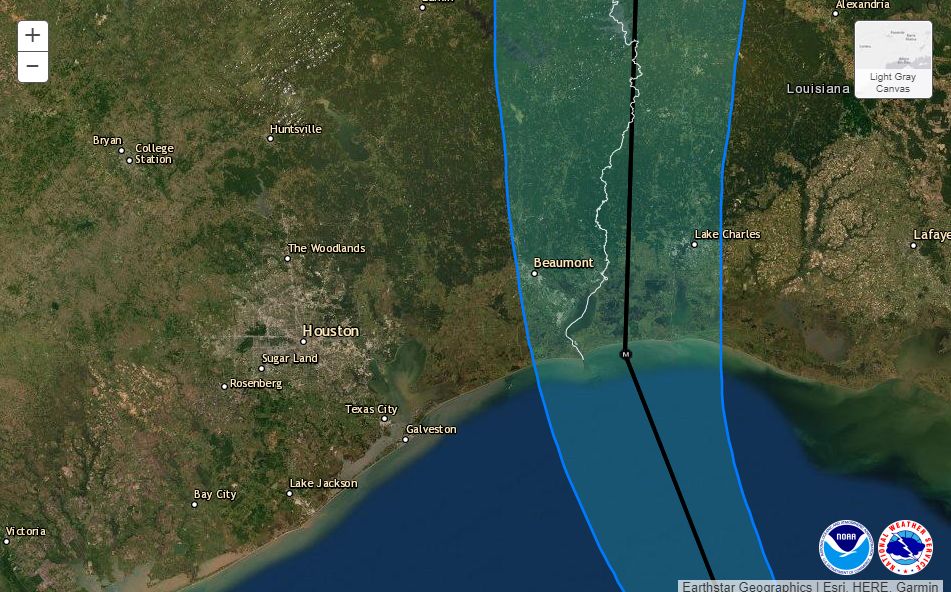
Below you’ll find the National Hurricane Center’s 4 pm CT track update. The track line remains the same, but the cone has moved further away from Houston as it has shrunk. There is high confidence in this forecast track. Laura is turning. It will continue to turn.

Power outages
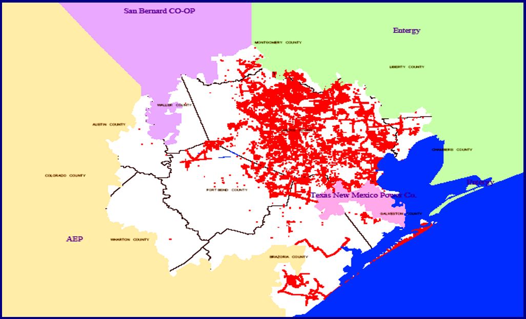
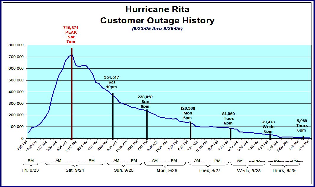
We continue to think the main issue tonight in the Houston area will be power outages due to localized, strong wind gusts that may reach 50 or even 60 mph. Sustained winds will be lower. Our best comparison for this event is Hurricane Rita. According to its financial documents, CenterPoint Energy had 1.9 million customers in 2005, at the time of Rita’s landfall. After Rita, the company reported that 715,000 customers lost power in its greater Houston service area, about 38 percent of customers. This map shows that most of those losses were on Galveston Island and clustered in the eastern half of its service area, as you would suspect.

About half of those customers had service restored by 10pm that night, and more than 80 percent had service back by Monday evening, about 2.5 days after the storm’s passage. Nearly all customers had service back within five days.

CenterPoint serves about 2.5 million customers in the region now. We don’t think outages will be as severe tonight for a couple of reasons. Although Laura is likely to be stronger than Rita at landfall, it should also be further east than that storm, and also has a smaller field of tropical storm force winds, about 175 miles compared to 205 miles for Rita. So we think there will be fewer gusts in the region, and the wind effects should be shorter lived as Laura continues to scoot along.
Hi, Eric! When crunching your numbers, please keep in mind that we now serve over 2.5 million in the Greater Houston area. Since Rita, we’ve also deployed new tech, such as smart meters and intelligent switching devices, to limit the number and duration of power outages.
— CenterPoint Energy (@CNPalerts) August 26, 2020
Additionally, after Hurricane Ike, CenterPoint began a program to “harden the system” within 35 miles of the Gulf Coast, and this involves changing wooden structures to concrete and steel. However, most of the electricity distribution system is still about 95 percent wood. In any case, it can’t hurt to charge your phone this evening, especially if you live east of Interstate 45, or close to the coast.
Our next post will come no later than 8:30 pm CT.

Do you have a similar map for any of the Entergy grids?
Thanks was going to ask the same thing. Much of the power from Entergy comes from either a plant in Orange or in Louisiana. We live in Kingwood and don’t expect much from the winds but if our power comes from other affected areas that might be a problem.
As I understand it, even if you buy your electricity from a company with a plant in [wherever], it doesn’t actually route to your house from there. In effect you’re just paying them to produce electricity and pump it into the area-wide power grid, your actual electricity comes from whatever (probably other) sources are more local. It’s like a co-op. So if the Orange plant goes out, you won’t immediately lose power, but it will degrade the overall supply of electric power in the region, possibly impacting everyone if the total supply drops too much.
I live in Humble in the back of Bush Airport. I lost power during Ike and wasn’t fixed for 2 weeks. When Centerpoint finally came out, we watched the repairman climb up the pole and flipped something and it came on. Two weeks of brutal heat and humidity and it took less than 5 minutes to fix. I only hope the response time is much shorter this time if it happens.
Appreciate your “just the facts” reporting, and supporting graphics and links.
Barbara, by no means do I mean insult, but you have no way of knowing what else on your circuit was damaged, or the extent it was. It’s a complicated system, and for safety’s sake everything has to be checked out before “the switch” can be flicked. You could have had wires down miles from your home that needed to be restrung. A transformer or a bunch blown out. Neighbors with exposed wires that had to be repaired. It’s a real pain, and having once been out for 6 weeks (Hurricane Celia in Corpus Christi 1966) I understand the frustration. But I have seen these guys wear themselves out trying to get EVERYONE back up. Sometimes it just ain’t easy.
Amen! My brother was in this business and he and his crews worked tirelessly to get people’s power on.
Barbara — they have to repair everything upstream of that switch first in order to get power to it, and then fix everything downstream of the switch to make sure they’re not going to fry something or someone when they do flip the switch. The switch is the final step to bring power back to the neighborhood, but it’s hardly the only thing that needs repaired before the switch is ready to be thrown.
After Ike they came to flip our neighborhood switch after 14 days without power, and it set fire to the trees along the back of my property because the power lines the switch energized were sagging too low from pole damage and were arcing to the upper tree limbs. It was pretty impressive. They had to do two more days of fixes before they could safely throw the switch again and we finally got power after 16 days.
Probably a fuse, but that may have been the last thing to fix in the process of repairing the line. Don’t jump to conclusions unless you know the entire story.
May Goss people, No hurricane live with the power issue!
Hi. I live next to Lake Houston on 1960. What are we looking at with wind conditions?
Matt’s 2pm update said:
Houston area: East of I-45, north of I-10 (Kingwood, Humble, Crosby, etc.)
Impacts peak between 9 PM and 4 AM with winds of 15 to 25 mph. Gusts will peak around 35 mph or so.
If I’m placing you right, that should be about what you’ll get.
All the informational graphs and just baseline info is off the charts! You look at the situation from all aspects and present that info in, as you promise, a “no hype” report!
Sure love spreading the word on you all!
Without question your our “go to” for weather!
Does HEB know something we don’t? They (and other grocery stores) in the middle and West of Houston where there will be no impacts are closing at 6 pm tonight. I have been following your blog the entire time and this makes no sense to me.
Although the businesses are in west Houston, their employees surely live all over the city. I imagine the early close will give employees a chance to close up and get home by the 8:00pm recommendation by the mayor.
I agree. That was my thinking too
It is possible that their employees don’t live directly nearby and need time to get home safely. I would not want to be driving with 50-mile-per-hour gusts. In addition, the City of Houston has asked for no cars on the road after 8 pm.
That’s to allow us time to get home safely.
My sister lived in west Houston during Rita, near Westheimer and Dairy Ashford. She had no power for nearly two weeks. My power, inside 610 near the west Loop, was only out for a few hours.
I am a little confused. Chan 2s weather radar from 8:15 this AM till 5:00 this afternoon shows Laura heading directly on a path to parallel 288 from Freeport right up to the 610 Loop. Is their radar wrong?
Yup
Why in the world would you watch that ridiculous station?!?
Thanks for all the updates. Well done guys.
Your regular and thorough updates are more appreciated than you know!! Thank you so much for keeping us informed, in detail, about Laura and what to expect across the whole area. Being informed sure lessens the stress! When this is over, have a good sleep! God bless.
Just curious why hurricanes always seem to make landfall during the night…..
No rush
For the same reason your home smoke detector batteries always die in the middle of the night. Beep. Beep beep.
Eric and Matt – thank you SO MUCH for your frequent updates. We trust your “no hype” reports😁👍
After this catastrophe has blown through, it would be interesting to see a “what if” template super imposed over a map of Houston to imagine what could have been.
Let’s not give 2020 any more ideas.
Agreed. We still have September ahead of us, and that’s an active month. We can pick up this conversation in November.
I was confused by the update saying Houston could get wind gusting to 50 mph at times, after seeing the chart saying my part of town (West of I-45) gets max wind of 30 +. I am basing where I stay Tonight on max wind…I have a potential tree issue and 30-ish mph won’t be bad but 50-ish could be. Thoughts?
That 30+ is probably max sustained wind. But higher gusts always happen and should be considered too.
Well we still have about a month to go until the historic time frame for tropical systems affecting Texas will close for this year.
I’ve heard Jim Blackburn (Rice Univ.) speak a couple of times about how we have by sheer good luck avoided avoided the scenario where a major hurricane moves into Galveston Bay and pushes water inland through our bayous.
background:https://www.texastribune.org/2019/07/29/rice-university-plan-texas-coast-barrier/
Our power was out for 10 days after Rita, compared to only 4 days for Ike (Champions area). The Rita winds were pretty fierce as I recall (yeah, not as bad as Ike). Tonight’s forecast has nothing like that for our area.
Pray for our neighbors to the east, and let’s all be ready to lend a hand when this storm moves on. It could be us the next time.
Well it seems more and more that Houston has really gotten lucky, but Louisiana doesn’t need another storm, either. It does seem like we lose power very easily in Houston these days, just a little rain or slightly breezy conditions and the lights are flickering.
Always appreciate your updates, pretty spot on reliability. Thank you!@
Do you have any wind gusts information for the meyerland area?
😊 thank you!