POSTED AT 8:20 PM CT WEDNESDAY: Hurricane Laura has made its turn to the north in earnest late this afternoon and evening, and is likely heading for landfall on the Louisiana coast, possibly near Calcasieu Pass, south of Lake Charles.
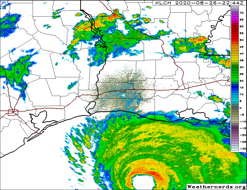
Wherever it makes landfall doesn’t mean much now short of who sees the absolute worst of the strongest hurricane ever recorded in this part of the Gulf of Mexico.
NHC made it official… #Laura is the first Category 4+ hurricane on the record for the current location. Barring a complete collapse… #Laura will also be the most powerful hurricane to ever strike the Sabine Pass region. #LAwx #TXwx pic.twitter.com/ChtfB59tqU
— Kyle Noël (@KyleNoel15) August 27, 2020
It’s going to be a hellish night for folks in extreme southeast Texas and southwest Louisiana. Nothing seems to be slowing Laura down, which is par for the course for a storm that somehow dodged nearly every conceivable hurdle imaginable in the Caribbean and brought us to this point. While Laura is still expected to come ashore “past peak,” it will still likely be the worst hurricane on record for this particular portion of the Louisiana coast. Conditions will now begin to rapidly deteriorate in far southeast Texas and Louisiana, progressing up to landfall around midnight. There’s really not much else to say at this point except godspeed to folks in the path.
Houston area
See our earlier afternoon post for a breakdown of what we expect in the Houston area and elsewhere. Most of these impacts are unchanged and may even be forecast too high.
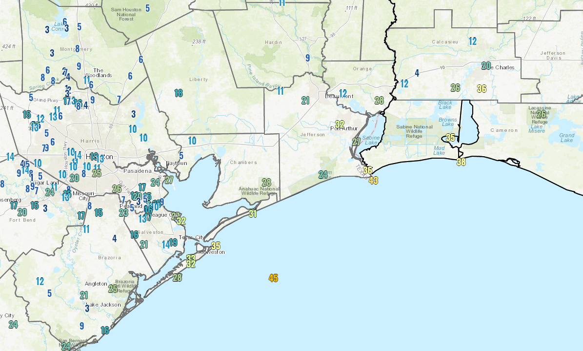
The highest wind gust as of 8 PM in the Houston area is about 25 mph at Hobby Airport. Galveston is gusting to around 30-35 mph. We do expect these gusts will increase a bit overnight, but with the storm now on a mostly north-northwest heading, we’ll see how far west the 30 to 40 mph gusts can make it.
There is surge still happening though, and the Bluewater Highway in Brazoria County is now closed from Surfside to San Luis Pass because of water and debris.
Bluewater Highway is now closed from Surfside City Limits to San Luis Pass due to high water and debris on the road. #HurricaneLaura #StaySafeBC pic.twitter.com/8GHl1uXGyg
— Brazoria County (@BrazoriaCounty) August 27, 2020
Surge levels look to be about 3 to 4 feet so far at San Luis Pass up through Galveston.
There are not many showers around Houston at the moment, and we will likely have a quiet evening. Rain could commence at times overnight, and it will likely fall east of I-45 and along the coast as Laura lifts inland. Our best chance of heavier rain in Houston may come in Laura’s “tail” wake on Friday. We’ll update you more on that tomorrow.
Eric will have our next post no later than 11 PM CT tonight.

Thoughts to those in Lake Charles. Please support the relief efforts that should be starting soon.
We made a donation to Red Cross today. They are always there, even before the disaster occurs.
I saw Katrina’s horrible destruction up close doing recovery work just a few days later. I hope every last soul got out of Laura’s way.
Looks like the bulk of the high winds wrap around north of the eye. I see the west side could get just as bad as the traditional “dirty side”, east.
All I can say is “Wow”. Praying for the folks.
I awash also in Gulfport a few days after Katrina. The Red Cross was there delivering two hot meals a day to piles of rubble. They’ll do the job.
As a native Houstonian who now lives in Lumberton, thank you for your continued coverage of this storm even though Houston isn’t in the direct path. It’s good to feel a little hometown pride even amongst the worry.
Our prayers are with these people. As Billy Bob said, now is the time to start relief funds. The Cajun Navy does a lot of good for all of us on the coast
East Liberty County here. I’ll be up watching the weather and waiting on the 11PM update. Don’t worry, I have PLENTY of beer…………
Hi Daddy!! 👋
I am relieved to hear you’ve provisioned yourself well. Did you remember to pick up extra gas to keep the generator, and that fridge, running for a week?
Thank you guys so much…..your information is vital and so helpful . I feel I am getting accurate and current information. Again, thank you for all ya’ll do!!!
All I can think of is Godspeed to those in the path of this destructive storm. It is a dichotomy to be both relieved for H-town, yet know at the same time how devastating this is for others.
Thank you for the up to date forecasting, it has been great to read, and refreshing because it is just the facts.
Looking at the last 30 minutes the eye appears to be expanding. Hopefully this indicates a slight weakening on the storm. I know, a fart in the wind and all that, but every little bit helps.
We need to mobilize the Texan Navy. The Cajun Navy came to save us during hurricane Harvey. It’s time to return the favor. Thank you both for the updates. When the weather is bad, I always, without fail, no exceptions, turn to you.
Thanks, Matt. We appreciate you!!!
Thoughts and Prayers to the people in Katy
Thanks for the dedicated coverage.
PLEASE go to bed after the 11 PM update and take tomorrow morning off.
I’m one of the tens (hundreds?) of thousands of people who so appreciate what you do for our community. Thank you and I hope you can get some rest.