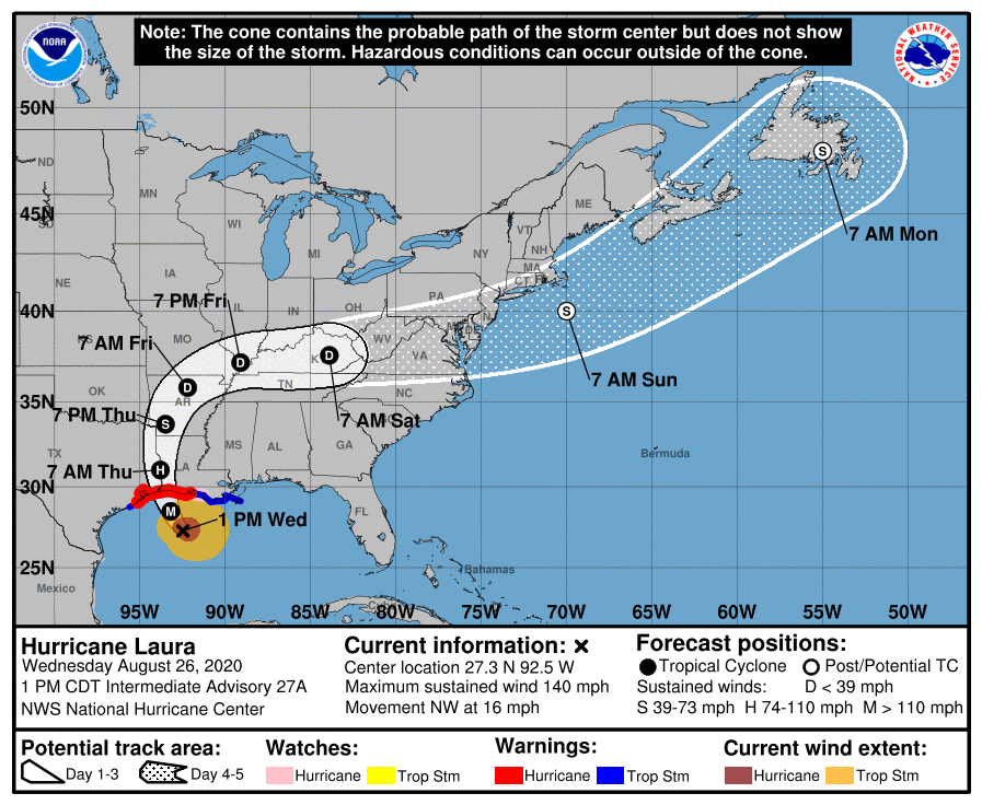
POSTED AT 2 PM CT WEDNESDAY: Good afternoon. Hurricane Laura has continued strengthening in the Gulf of Mexico all day so far, showing no signs of slowing. It is now up to category 4 intensity, with maximum sustained winds of 140 mph.
Could Laura achieve category 5 status before landfall? It’s possible, as there are no signs of strengthening slowing down as of this writing (pressures keep falling). Laura is expected to come ashore below its peak intensity. It may feel the effects of some wind shear, shown in red on this map below.
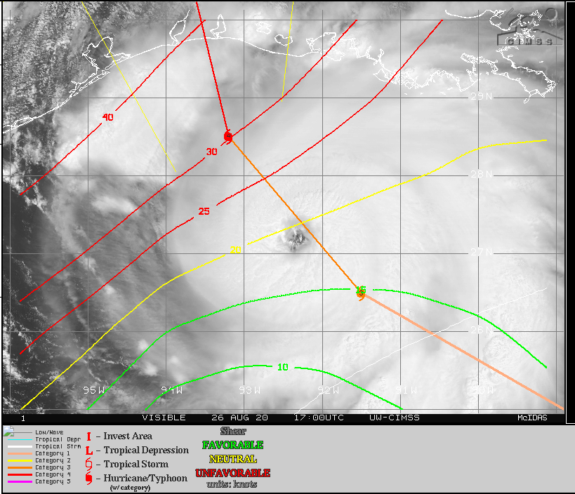
That shear is moving with Laura to the north, so it may not help as much as you’d otherwise hope. More likely, Laura could experience what is known as an “eyewall replacement cycle” before landfall; basically a way for the storm to reorganize itself. When that happens, a drop in intensity usually occurs, sometimes substantial. We hope this happens right before landfall, which would allow Laura to come in on the decline, rather than at maximum intensity. Unfortunately, this aspect of the forecast is difficult to predict and we are really only relying on hope at this point. It’s possible Laura could just continue strengthening right up to landfall, similar to what Hurricane Michael did 2 years ago near Panama City, FL, though as a colleague of mine pointed out in a conversation earlier, the coastal topography of the Gulf here is much more shallow than off Florida. Shallow water can be more easily churned up and help to reduce the fuel available for hurricanes to feed off of. Whatever it is at landfall doesn’t much matter at this point, as it will still likely be bad.
Laura is moving northwest at 16 mph, which is blazing fast for this part of the Gulf. For folks in Houston, it’s important to know that Laura is doing what is expected, and “the turn” is underway. It’s not “if” or “when.” It “is” happening, and thankfully in the world of 21st century meteorology we can say that with authority. We will not be hit too hard here by this storm. Laura is expected to make landfall on the Cameron Parish side of the Texas/Louisiana border as a category 4 hurricane tonight perhaps around or just before midnight.
Let’s walk you through the expected wind and surge impacts at this time.
Houston area: West of I-45 (The Woodlands, Katy, Cypress, Sugar Land, etc.)
Periods of showers and thunderstorms possible to likely tonight. Impacts peak between 9 PM and 3 AM with winds of 15 to 25 mph and gusts as high as 30 mph or so.
Houston area: East of I-45, north of I-10 (Kingwood, Humble, Crosby, etc.)
Impacts peak between 9 PM and 4 AM with winds of 15 to 25 mph. Gusts will peak around 35 mph or so.
Areas around or just inland from Galveston & Trinity Bays (Bay Area communities, Texas City, League City, Baytown, etc.)
Impacts peak between 8 PM and 4 AM with sustained winds of 25 to 35 mph and gusts of 40 to 50 mph, highest south, lowest north. Surge of 1 to 3 feet, though northerly/northwesterly winds may push water to the south toward Galveston
Galveston & Bolivar
Impacts peak between 8 PM and 4 AM with sustained winds of 30 to 40 mph and gusts of 50 to 60 mph, or a bit higher possible. Storm surge on Galveston Island is expected to be on the order of 1 to 4 feet, with the bay side experiencing surge as well. Storm surge on the Bolivar Peninsula may be as high as 4 to 5 feet.
Beaumont-Port Arthur-Orange area
Impacts peak between Midnight and 5 AM with sustained winds of 75 to 90 mph and gusts of 95 to 110 mph. Surge of 10 to 15 feet into Sabine Lake.
Lake Charles area
Impacts peak between midnight and 6 AM with sustained winds of 75 to 100 mph and gusts of 95 to 120 mph. Storm surge of 15 to 20 feet into Calcasieu Lake.
Rainfall
Just to further put you at ease, the total rainfall through tomorrow in the Houston area is expected to be 1 to 2 inches total. Many places will likely see less than this. A few to the south and east may see a bit more.
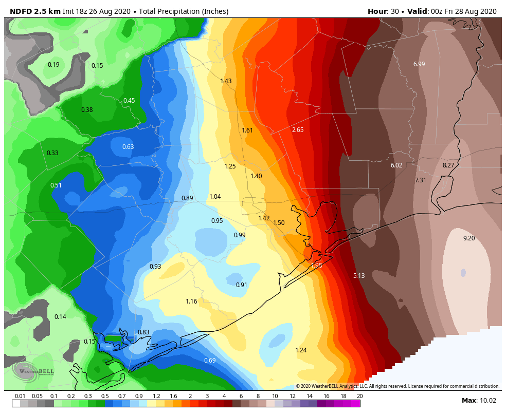
But in this case, flooding, other than some nuisance street flooding is not expected. On Friday, we may see a slightly better chance of some heavier rain as modeling has been in agreement on a better signal for storm chances from a trailing band feeding into Laura’s remnants over the Mississippi Valley then. Something we’ll check into more closely tomorrow.
So again, just to summarize, Laura is moving northwest and will turn more north-northwest this evening, likely making landfall on the Louisiana coast, well east of Houston, as a major hurricane. Eric will have our next post no later than 5:30 PM CT.

Thanks so much for your continued updates. From a non-meteorological perspective, Laura still seems to be taking aim at us. I’m glad to hear that’s not the case, but I’m still incredibly worried about those in the direct path of the storm. Let’s all hope Laura weakens before landfall.
Thanks for the earlier than expected update!
Since I have to ask a dumb question on each post, are there any other impacts to the eyeball replacement cycle? I’d guess that energy loss has to go somewhere, does it get lost as waste heat or get pushed out as stronger winds for a bit, or something else?
Eyeball replacement sounds painful. 😉
Basically, the Eye gets faster and shrinks, when that happens a second eye on the outside that is wider (because it’s weaker) can form, and as it starts to condense the outer robs the inner of its moisture and angular momentum (think of a top falling as it gets slower), and becomes the new eye. the New eye HAS to be larger, so it’s weaker (because smaller eye = stronger, larger eye = weaker, as a general rule)
Phewwwww. That was a LONG 36 hours.
Thanks guys. This place really is a gem.
Hopefully the forecast track holds. When storms become this powerful they tend to move where they want.
Thank you for the brief forecasts for the various Houston-area localities, and for the reassurance about the storm’s northward turn. Thankfully the message about this storm’s danger seems to have been received and the SW Louisiana and Golden Triangle folks I personally know have already evacuated.
My family is in Rapides and Grant parishes. What can they expect?
This “near-miss” points up the need to expedite the funding for the overdue solution to the coast and particularly Galveston Bay, whether the Texas Coastal Spine or otherwise.
NO COASTAL SPINE!
Yelling is such a solid debate strategy.
I found it particularly effective. I was not familiar with the project and would have skipped over that particular comment but for the all caps response.
Reading up on it, it seems like a good idea. I’d be interested in hearing more about why it might or might not be effective, but as an initial proposal the relatively low cost compared to potential losses makes it a very good idea.
Why not? What’s wrong with it? I look forward to hearing your professional opinion. I assume you’re an engineering professional with facts and figures, rather than someone just repeating dumb crap from facebook.
Absolutely! Think of the potential environmental disaster if the Ship Channel spills over.
What would the predicted storm surges mean for Beaumont, Port Arthur, and Lake Charles? I’m assuming that translates into very heavy flooding for Lake Charles and Port Arthur, but is Beaumont just high enough and far enough inland to escape devastation?
Thanks for all you do, and am serious. Where would you and Eric like your beer and whisky deliveries? Favorite brands?
I like this idea! Can’t thank these guys enough! I’m sure they could use a couple of pizzas to go with that beer!
Every year they have a fundraiser to raise money to keep the site going. Pay them then!
Thank you guys!
Will be interested in finding out the reason behind the rapid and late intensification once this is all over (and Matt and Eric get some sleep!).
Thanks for the update. Another monster storm. Is there any statistical evidence that cyclones have been getting more intense recently, say in the last 10 years? That is my gut feeling but I admit I may have a cognitive bias since that’s when I bought my first home.
Yes, the anxiety level goes way up when you own property!
Yes. They are getting bigger and more frequent due to climate change.
Dr. Neal Frank Used to talk about the “jog to the right” (or was it left?) that gulf coast ‘canes make shortly before landfall. 40-50 mile change of course.
Does anyone else also recall that description?
This time round I’ll be watching for Laura’s last-minute moves.
I’m pretty sure that is a feature of strong cyclones. They all want to head poleward, and since most Gulf hurricanes are traveling west, then north is to their right.
Just trying to learn and understand….why do they head poleward? Thx!
Conservation of Angular Momentum
thanks
https://www.sjsu.edu/faculty/watkins/hurricane.htm#:~:text=Tropical%20cyclones%20(hurricanes%2C%20typhoons%20etc,are%20thus%20forced%20to%20precess.&text=The%20conservation%20of%20this%20angular,an%20acceleration%20to%20the%20east
I remember Dr. Frank but notvwhuch way the jog went. I’m in Katy and now afraid we won’t get any needed rain. We’re never pleased are we. B
DNF was on Michael Berry’s radio show this morning. He mentioned that the storm “tilts” first one way, then the other; so hourly predictions can be tricky.
Pasadena? We lost everything with Harvey!
Again Thank you, especially for the area information. I was just looking for it and you posted. Great job as always.
Thanks for the great on going info on the storm. No hype, just the facts!
Interested in areas/counties north of the Golden Triangle — Hardin, Liberty, Tyler, Newton, Jasper — what conditions they might expect and when. These places took a serious hit, along with the Golden Triangle during Rita. Thank you!
could you give us some technical data? depth of low in mb, eyeball dial, wind spread diameter, altitude of the tops, etc?
spellcheckers!!
Lots of expectations on areas surrounding Houston but can you tell Houston itself what to expect, please?
Can you be any ruder – especially at a time like this? He mentions The Woodlands, Katy, Cypress, Sugar Land, etc. and Kingwood, Humble, Crosby, etc. You have embarrassed your mother. I’m sure she taught you if you don’t have anything nice to say, say nothing at all.
Your response is rude. The whole post talks about impacts, You are also a click away from NHC which has all the data, in simple form, right there. And finally he writes:
Houston area: West of I-45 (The Woodlands, Katy, Cypress, Sugar Land, etc.)
Periods of showers and thunderstorms possible to likely tonight. Impacts peak between 9 PM and 3 AM with winds of 15 to 25 mph and gusts as high as 30 mph or so.
Houston area: East of I-45, north of I-10 (Kingwood, Humble, Crosby, etc.)
Impacts peak between 9 PM and 4 AM with winds of 15 to 25 mph. Gusts will peak around 35 mph or so.
Should he say, “if you are standing at 45 and 10 you will get 25 mph winds and 1″ of rain”. Sorry man, but come on.
Your mom must be embarrassed. You went there.
Agreed!!!!
K!!!!
Why do you find it so hard to be kind at a time like this, do you just need attention, seriously, be supportive or keep your comments to yourself.
Yes! Any little tidbit would help!
Not nice. Evereryone who has experienced this before is a little stressed out right now, so please be a little more kind with your response. Your scolding also clogs the comments, BTW
Damn fine reporting Matt and Eric! Space City Weather has become my “go to” source for no-nonsense weather information. Appreciate all your hard work, guys!
Thanks for your hard work on Marco and Laura! It appears there is another storm out by the lesser Antilles. Is that something we need to focus on?
This is 2020 Nothing will surprise me God I hope it stays on the path it is suppose to I am sorry for LA tho
Will it be safe to drive from The Woodlands to the Galleria (45 &I-10) from 9pm to 9:30pm tonight? I don’t have a choice about when to drive. Trying to determine if I need to stay in a hotel and wait it out. Not sure how the information about west of I-10 impacts driving conditions
I meant west of 45
Thank you guys for reporting the weather without a lot of hype. Here in our home we really appreciate your weather forecast to our email adresses My heart bleeds for those people that are gonna be hit by this. I feel kind of bad for being thankful that we’re not the ones in the path and thankful I am. Have a safe and uneventful evening. I’m sure all of our prayers go out for the folks in Louisiana and the innocent animals in the wake of this devastating storm.