Good evening. Tropical Storm Nicholas is nearing the middle Texas coast and should make landfall near Matagorda Bay within several hours. The storm’s maximum winds increased to 65 mph this afternoon, and it’s quite possible Nicholas will become a Category 1 landfall before landfall tonight. Wind gusts from Nicholas are starting to arrive along the upper Texas coast, and should peak around midnight or during the wee hours of Tuesday.
As Nicholas nears the shore we are starting to get more confidence in rainfall forecasts for tonight and Tuesday morning as the heaviest rains from the storm move through. And as a result of this we are lowering our Flood Stage alert for all but coastal counties.
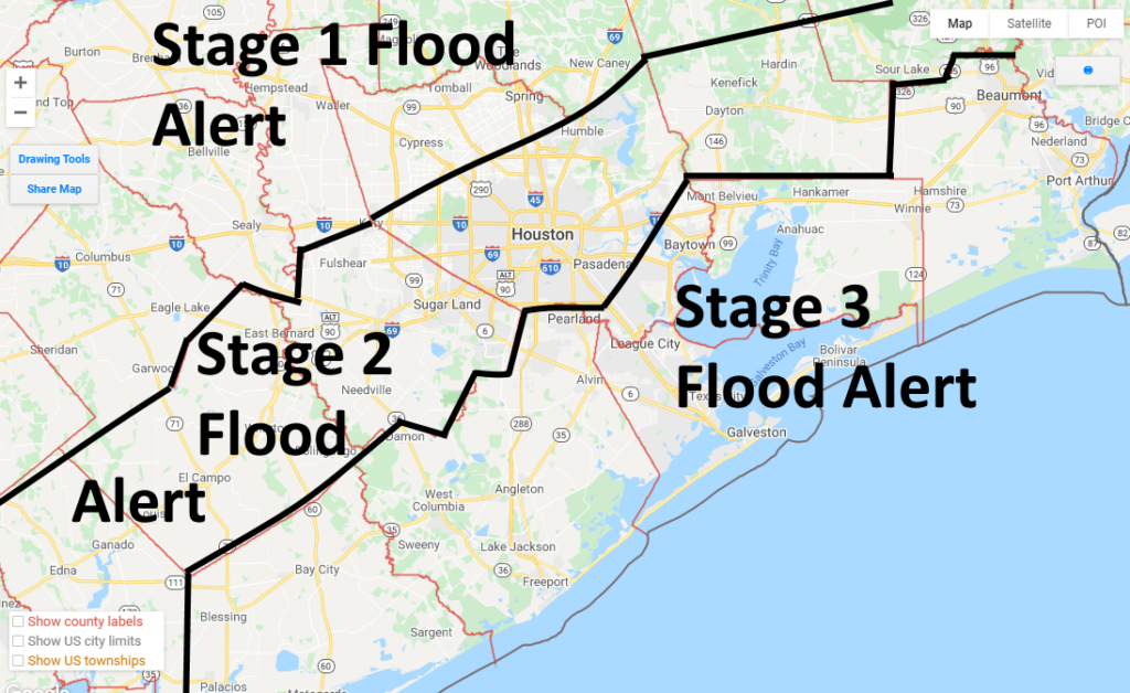
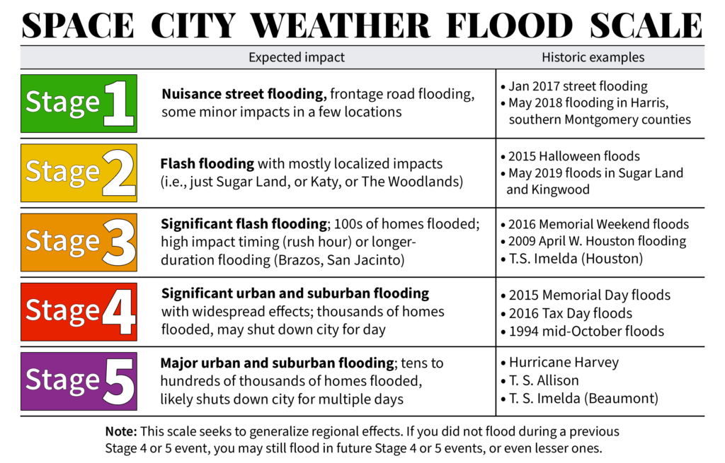
As you can see on the (very professionally drawn) map above, we are keeping a Stage 3 alert for coastal counties, Stage 2 for the next tier, and Stage 1 for areas northwest of Houston. Basically, if you live near the coast, an additional 6 to 12 inches of rain is possible tonight, with higher localized totals. For areas roughly along Interstate 10, values should be about half of this, give or take. And for areas well inland, overall accumulations will likely be 3 inches or less. As a reminder here’s what our various flood scale alerts mean:
Timing of events
The overall pattern for events tonight should not change a whole lot. Heavy rainfall will advance from the southwest into the Houston region tonight, likely reaching a corridor from I-45 South to downtown Houston around midnight, or an hour or two later. These storms will then continue to push to the northeast, perhaps moving away from Harris County by around sunrise or mid-morning.
Maximum wind gusts of 50 to 60 mph will likely move into Brazoria and Fort Bend counties by late evening, with gusts in the 40s reaching Harris County by around midnight. These winds should begin to weaken by around sunrise on Tuesday morning. Expect scattered power outages, at least, as trees and debris fall into power lines.
We think conditions may begin to improve across the area by around sunrise on Tuesday, or perhaps mid-morning. So our advice is to not have any concrete plans for Tuesday morning, as we cannot say a whole lot about conditions with confidence. By Tuesday afternoon we expect conditions to improve markedly. At this point we think Wednesday should see a return to normal activities across the region without too much difficulty, and excluding any areas that saw widespread flooding on Monday night.
Our next post will come by around 10 pm to fine-tune the forecast for tonight and Tuesday.
Thank you so very much for including the Beaumont/Port Arthur area in your excellent forecasting. Your efforts are greatly appreciated.
Orange??
Near Beaumont/Port Arthur.
Yes, half way between the cities of Red and Yellow if I remember correctly.
The Stage Flood Diagram was very helpful, thank you for taking the time to create ❤️
I’m in Baytown very close to IH10, looks like we’re on the border for scale 2,3
Your “very professionally drawn” map looks a little too similar to a Sharpie added cone of uncertainty near Alabama from a couple of years ago during Hurricane Dorian… 🙂
Thanks for the constant updates and details you provide. Much appreciated!
Lol
lol. Oh, the Sharpie.
Thanks for updates. Lake Jackson getting decent wind gusts, not much rain…yet.
Unlike the one who used the unauthorized Sharpie while in the Oval Office, Eric can use a Sharpie with no issues.
That map is just… so professionally drawn. I can’t get over it.
I agree. The areas within each flood stage are easily seen and understandable. Thank you for such a beautiful map.
Thank you as always
I’m in Stage 3, huh? Hopefully all that money we spent on Exploration Green pays off. Or maybe you guys could re-draw the line a little further south so I don’t flood?
I love Exploration Green!
Lol… this comment made my evening
Thank you guys
Getting blustery in Bellaire.
Facts and science! Oh so refreshing!
Houston Strong!
Getting blustery in LaPorte too..
Great map guys! And so thankful to be zone 1. Thanks again for clear reporting.
I noticed that the latest NHC track has the center going right over downtown Houston. A couple of hours ago they had the track going over FM 1960 near highway 249. I just hope the power doesn’t go out up here. It doesn’t take much of a breeze in our neighborhood for it to go out.
Thanks for the no-hype forecast and for settling jitters by poking fun at yourself.
I’m in the League City West area along the creek that flooded once in the ’09 April shower and again in ’17 in Harvey but the city put in drainage behind the house. Here’s to hoping it can handle a Stage 3-4 with no problem! In any case, best advice for anyone is to take a camera to all your rooms and belongings so you can fill out a loss report for a quick property damage return.
Here’s hoping you don’t have to go through that again, though.
Just moved here from Chicago and it is a comfort to get your emails with updated weather reports. Thank you!
Hey Beth, Northwest Sider here 🙂
I’d like to buy you guys a beer. Sugar Land area, just let me know.
“The storm’s maximum winds increased to 65 mph this afternoon, and it’s quite possible Nicholas will become a Category 1 landfall before landfall tonight.” cat 1 landfall before landfall?
In theory, if it crosses a barrier island first and then the bay, then it can have a cat-1 landfall and then landfall landfall later.
This bit of useless pedantry brought to you by a math major. 😀
marc, You forgot to include your emoji. I think what he meant was “….a Category 1 landfall “AT” landfall.”
1!:~/-}
We were watching your updates all day today. Thanks so much for keeping us all updated. My cousin made some super cute stick people drawings of stringing some air mattresses together to do high water transport of family and pets in 77025 which made me think of and snicker with your “very professionally drawn” map.
So does Katy need to evacuate?
Yeah, that big black line running right through the middle of town can’t be good…
That’s not funny anymore.
It was never funny.
How high do you guys figure the wind will be in Jamaica beach overnight?
As always, thank you for insightful, no bullcr@? Forecasts!!
We are in Brazoria County on the chocolate bayou which is stage 3…thank you for keeping us updated on this storm
Is La Porte in Stage 2 or Stage 3 (I’m in La Porte near Underwood & Spencer Hwy)? The lines have me a bit confused. Thanks for the update, take care & stay safe.
Could be either if you’re on the line obviously. This is a forecast, they don’t have a time machine to go into the future and give you specifics
Thanks, guys! Y’all are amazing, as usual. Any tornado threat with this storm? Thanks!
I just dozed off while watching local weatherman. Is it over?
Because it’s funny, maybe! Get a sense of humor and stop being so rigidly entrenched. Anyway, the sharpie is an excellent choice to delineate here and I hope it’s not far off the mark.
It’s turned a deep yellow with an orangish hue out there. Maybe just a lovely sunset or maybe a nice storm. Either way, are your street sewer drains nice and clear? I just finished mine and got quite a hefty amount of debris out. All it takes is some grabbers (or a rake), some glove and a receptacle to dispose of it. It’s nice to start a potential flooding situation by clearing out what we can in advance. Please take advantage of this time if you are able to.
Storm drains! You knew what I meant. 🤣
Thank you, thank you, thank you! For the reliable updates during this stressful time.
Thanks go to your families too for sharing your time with us.
You know what folks…unless my eyes are deceiving me this storm appears to be moving ENE. If this trend continues it may not even make landfall.
I live in Cypress.
Flooded Tax Day and Harvey
Your very professionally drawn map is a beautiful sight to me!
Thanks for all your work to keep us informed.
Looks like we’re OK in southern Grimes County. Thanks again to SCW.
Nicholas is a bust. Here at the house (Richmond, Fort Bend County), we’ve had 1 inch of rain in the last 18 hours and now all precipitation is moving off to the east. No gusts over 25 MPH. Must be Nicholas’ inability to form a center of circulation.
If nothing else it’s pretty nice out. 71° with only 90% humidity. Light north wind at 2 mph. The weather folks say we are getting 15 gusting to 25. I got news for them!
I’m in 77095
Not necessarily. I’m near Ellington and hoping I don’t get woken up at some odd hour by a 4+ inch/hr rain. Had 3.0 in/hr this afternoon.
Wind just picked up SIGNIFICANTLY in the last minute. Can hear it whistling from inside the house.
Amazing what 40 miles separation can do! Stay safe…
East of us. Lucky for us. Diff story south and east of Houston. Look at the radar.
This update didn’t sound so threatening. Thank you.
So do we have work tomorrow or no?
Yep. No snow day for you!