‘Twas the night before Tuesday, when all through the city
None were stirring, not even Harry Styles more’s the pity;
Dry stockings were hung by the chimney with care,
In hopes that St. Nicholas soon would not be there.
Alas, Nicholas is here. And he’s bringing lumps of coal for all. So we’d better discuss the forecast.
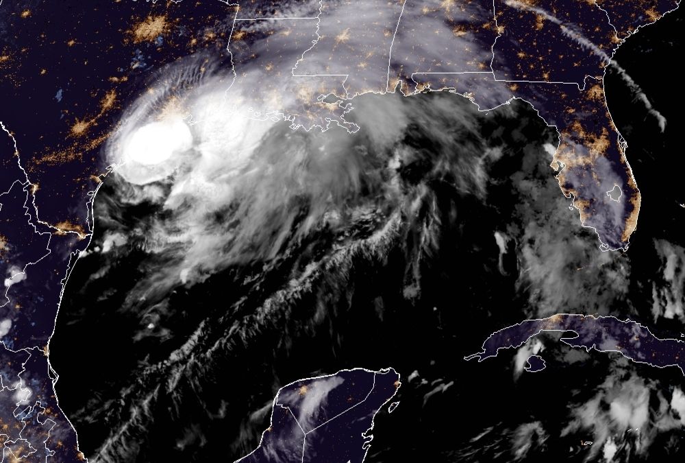
As of 10 pm CT, the National Hurricane Center says Nicholas has become a hurricane with 75-mph winds. Its center is presently located 20 miles southeast of Matagorda, Texas. The storm is moving to the north-northeast at 10 mph, and should come ashore the upper Texas coast later tonight, possibly near Sargent, Texas. No additional strengthening is anticipated, the hurricane center says. The storm is expected to cross the Houston region on Tuesday morning and then move into southeastern Louisiana and essentially stall before dissipating by Thursday or so.
Houston area rainfall
Our overall rainfall forecast remains largely unchanged. If you live inland of Highway 59 and Interstate 10, you’re very likely to miss out on heavy rainfall overnight and into Tuesday morning. My expectation would be for 2 inches, or less. If you live closer to the coast, particularly in Brazoria, Galveston, and Chambers counties, heavy rainfall is much more likely. Widespread totals of 4 to 8 inches are likely, with bullseyes of 10 inches or more that may produce localized flooding.
The radar image below tells the tale of the night. We can see the main band of thunderstorms along the Texas coast, but mostly offshore. This band of gnarly storms will to move to the northeast tonight, and how bad things get for the Texas coast will depend on how far inland it gets (or how far offshore it remains). Right now I’d be surprised if the heaviest rains pushed much farther inland than League City tonight. But we’ll see. I’ve also annotated the line where there’s no rain now. There probably won’t be much precipitation west and north of this line tonight, either, as Nicholas moves to the northeast.
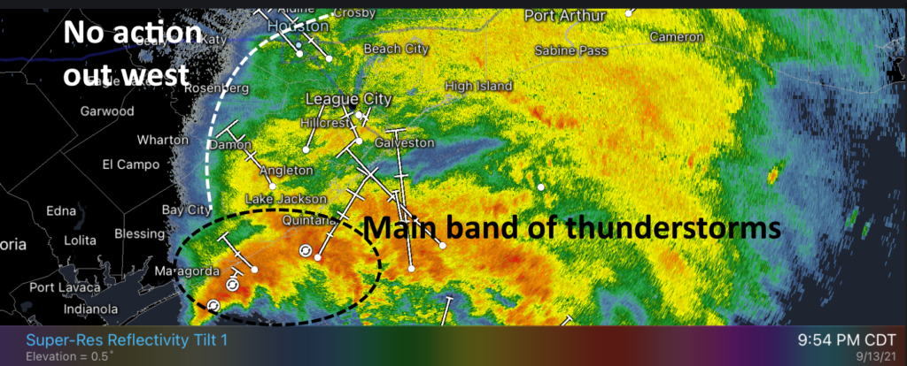
As this system slogs toward the northeast over night, it will have the potential to drop rainfall across all Texas coastal areas. However, for now, it appears the heaviest rains will come over Galveston and Chambers counties, with lesser amounts further east, including the Beaumont and Port Arthur areas on Tuesday morning.
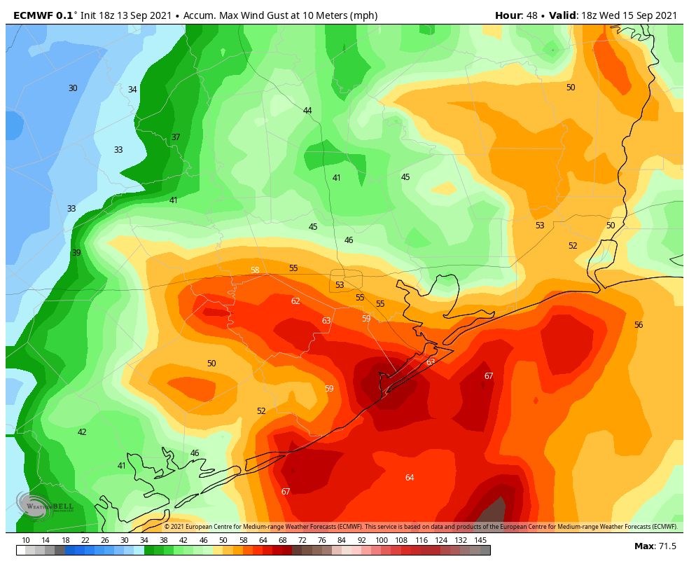
Wind and power outages
For inland counties, including Fort Bend and a majority of Harris County, this now appears more likely to be a wind storm rather than one of significant rains. As of 9:30pm about three quarters of Matagorda County were experiencing power outages as Nicholas battered its shores with hurricane-force wind gusts. These winds, although diminished, should spread inland over the next several hours. I’d expect at least scattered outages as trees fall into power lines.
When does this mess end?
Our confidence in when the heaviest rains from Nicholas push east of Houston remains middling, but I’d expect rains in Galveston County to wind down around sunrise or mid-morning.
Our next update will come at around 1 am CT.
Thanks guys. Excellent coverage.
Hitting hard in Galveston right now.
I’m in Katy. With a hurricane coming, should we consider evacuating?
You must not be from around these parts
Oh, I suspect she’s been here awhile…
(It’s a bit of a joke that goes way back.)
From what I’ve read to this point, I don’t think it is necessary to evacuate. Storm is moving northeast, not northwest. Keep checking weather updates though.
Yes. I evacuated to Cypress!
You’re much better off staying where you are at this point, getting on the roads right now would be risky. But evacuating is probably unnecessary anyway, Cat 1s like this usually aren’t super dangerous as long as you’re indoors. Roads will see some flooding, but unless Nicholas stalls over the Houston area (it isn’t expected to) you should be fine. Prep for a power outage though.
“Sunset or mid-morning”?
Corrected
We appreciate you guys so much!
I’m incredibly impressed with your reporting . It’s so nice to be spared the hysteria. Thank-you for your excellent work.
Thank you so so much!
Just wondering how bad of a wind event this may be if we have power lines in ground. I can handle floods. I hate loss of power. Trying to prepare. Thanks for the updates!
Shouldn’t be a problem but you can still be affected by things upstream or downstream.
Can you elaborate on Shoreacres, Laporte, clear lake ect.. still harris county but yet still considered somewhat coastal. We always seem to get left out.
Cute little poem.
Is Nate Silver doing weather forecasting now? How could they have all been so wrong. Business closed and concerts were cancelled in Houston for no reason. People will not take future threats seriously when it is this much of a non-event for Houston compared to what was forecasted.
Go back and read the prior updates. The only people who will dismiss their reporting in the future are those who couldn’t understand nuance and predictions of variability in the first place. It wasn’t going to matter to them.
Are you new to hurricane season or something? Houstonians are THRILLED this thing ain’t coming for them. After Harvey nobody will be taking hurricanes lightly for at least several years.
50 miles difference in the track could have made a world of difference. 50 miles to the west and we’d all be howling, instead of just the folks south of Houston.
Were you around for Harvey? Flooding is serious. I’d much rather be safe than sorry, especially when it’s only a couple times a year. It’s important to keep our community safe.
Lee are you serious!?! Do you know how many lives were lost in the North east because they took the last storm lightly and warned the people the day before!? Do you know how many lives were saved on the gulf coast because they warned them to evacuate? You should be praising these people to be giving us updates every couple of hours.
It’s the models that were wrong. The forecasters are largely interpreting the models. What is wrong with the models though? Only a day before the storm hit the models were saying it was supposed to go west of Houston. The storm appears to be moving almost parallel to the coast, but the models have it turning more northward, moving through Houston, and then turning back east. Yesterday it was supposed to keep moving northeast, but now the remnants are supposed to turn due east and then stall or something over LA.
Yesterday the forecast was around 5 or 6 inches where we live, but it appears now that we won’t receive much more than an inch or so overall!
Remember when everyone thought Harvey was a nothingburger (exaggerated forecast, etc) and many went out that Saturday night like everything was normal? A lot of people found themselves unable to get home. It’s always better when a tropical system is making a beeline toward Houston to err on the side of caution than get stuck in a flood. Harry Styles can wait.
I’d like to see you try to predict this correctly so I can yell at you when you inevitably get it wrong. Who woulda thought predicting the future wasn’t easy.
So dash away dash away … Thanks for your lighthearted poetic style. Much needed accompanying the real facts! TTFN (ta ta for now). Sweet dreams, y’all.
Ok… I say this with all love: get some sleep, guys! Your poetry is magnificent 😂
Thank you so much for the non-hysterical update. Do you guys ever sleep?
We are really starting to rock n roll in Freeport
We’re actually getting a couple of gusts in the 20mph range here in the Champions area, after a quiet evening so far.
Hi Eric and Matt, I recently found the national data bouy system on NOAA ( search for noaa bouys) and it shows 5 minute historical data on wind speed gust and pressure ( and other metocean stuff) U can track the storm centre as it moves up the coast. Also has some inland stations too. Maybe u can share on one of your posts to everyone
And here we sit in CC wishing we had local weather.
Seeing gusts >30mph in 2nd Ward.
How about expectations for Brazoria County? Looks like the storm is going to work its way up toward Houston across us?
Great forecast. If we do lose power then I hope it’s at least after I’ve had my morning coffee.
Thanks for staying up and giving us the best no hype Updates. Appreciating you from Pipers Meadow in Clear Lake Area.
Thanks for the timely information! A few typos but those things happen when you are trying to get it out fast.😉
Thanks as always for the updates…..I hope everyone stays safe….This to Will Pass….
You said “wind down around sunset or mid-morning.” I presume you meant “sunrise or mid-morning”. Thanks for the frequent updates/
Great work. Love the updates.
Just tucked in and dozing. Listening to the rain and winds. Wake up and check the posts. Sleep some again. I might watch the radar for a while first. Glad it is more likely to make landfall east of us. Better to be prepared than not, especially after Harvey. I also remember what a TS like Allison can do. If this is a first storm for some, you really need to look at historical data for some of these storms.
My guess is that “…. live inland of Highway 59 and Interstate 10,….” means if you live northwest of the intersection of Highway 59 – EastTex Freeway and I-10 – Katy Freeway with Highway 59 – EastTex being the east boundary and I-10 – Katy Freeway being the south boundary then…
Coastal huggerish?
Thanks so much for all you do! I feel more relieved reading your report; saves me from feeling panicked! I haven’t had any power outages at my house yet, luckily! I’ll be ready though if it does; got my phone charged 100% at the moment.
I live off old Highway 90 just out of Houston City Limits – NE Harris County
“My expectation would be for 2 inches, or less” was your prediction. Very accurate
The Rain Gages around my area are right at 2" or a little fraction over at 05:50 Tuesday Morning and that is an all the incident accumulation. We had a blast of wind that dropped some branches about 45 minutes ago. Resisted the temptation to go outside and look until it gets light and the wind dies. My family made me promise.
Semper Fi,
TXSFRED