Good afternoon. Much of Houston is seeing a reprieve from storms after a band of showers moved through the region around noon. It looks as if rain showers will remain somewhat scattered and non-threatening through the late afternoon or early evening hours. The main event is still offshore, and will reach our region later tonight.
Speaking of the main threat, Tropical Storm Nicholas retains 60 mph winds as of 1 pm CT, and continues to move north toward the Texas coast. It likely will make landfall near Matagorda Bay later this evening. The storm covers nearly all of the western Gulf of Mexico this afternoon.
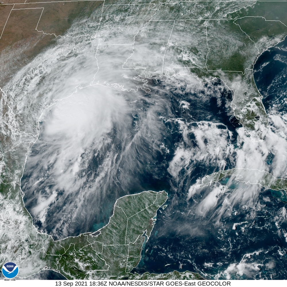
Throughout the day, we’ve been getting our first inputs from high-resolution models about rain accumulations tonight and on Tuesday for the Houston metro area. The early returns suggest that most of Houston may fare pretty OK from rain dropped by Nicholas. We still have some very serious concerns, however. Let’s discuss.
Our confidence is increasing that a line of storms associated with the core of Nicholas will move into our region from the southwest tonight. It looks like these storms will reach Brazoria County around midnight, or shortly thereafter. Then they should progress toward downtown and the I-45 South corridor some time after midnight and before 6am CT on Tuesday. This is a little slower than previously anticipated, and may give Houston residents a few hours after sunset this evening before roadway conditions deteriorate. (Gusty winds will probably also arrive in Harris County around midnight, or after).
The other major shift we’ve seen in some of the model guidance is that the threat for heavy rainfall is becoming more concentrated along the coast, in places like Brazoria, Galveston, and Chambers counties as well as the Clear Lake area of Harris County. If this forecast holds, areas inland of Interstate 10 may see only a couple of inches tonight, whereas the coast will face a higher threat of 5 to 15 inches. One of our big questions right now is whether the heaviest precipitation falls offshore, or along the coast in places like Matagorda, Sargent, Freeport, and Galveston Island.
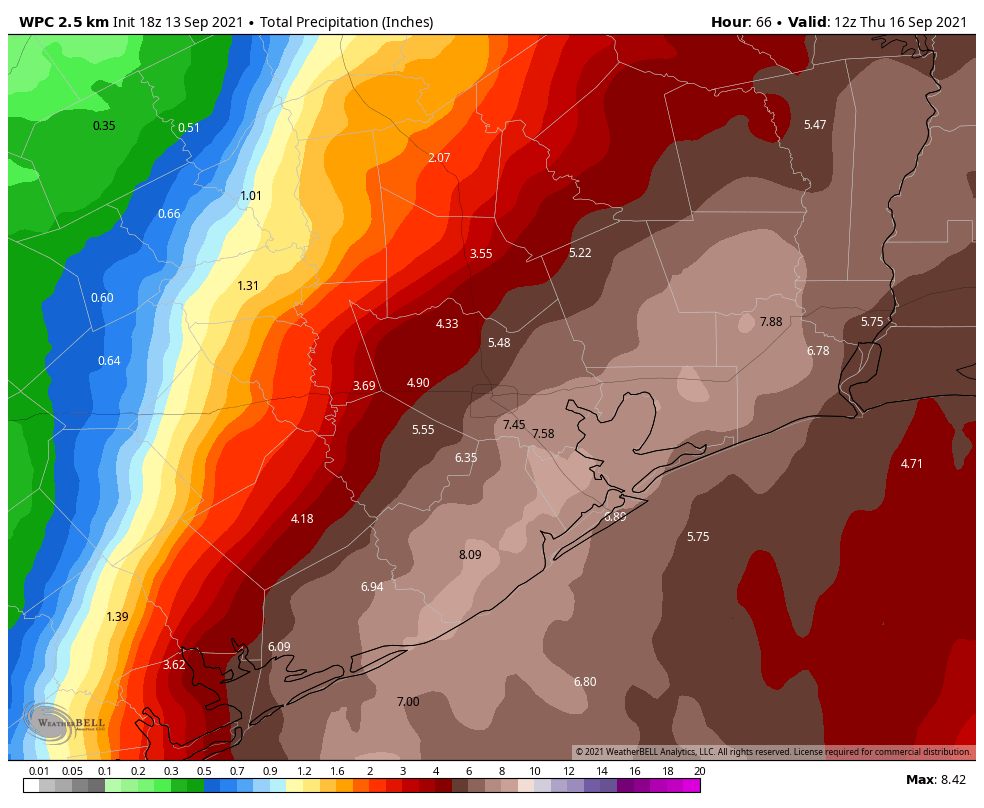
Matt and I have discussed this quite a bit this afternoon, and for now we’re holding to a Stage 3 flood scale warning for the entire Houston metro area. But that probably oversells the threat to locations north of Interstate 10. We’re going to continue to look at more data and decide whether to reduce our flood scale warning later today. We’ll leave you with this: It’s OK to have some hope about the Nicholas forecast, but we still have a lot of questions and a very explosive, tropical air mass headed this way.
Our next update will come at 6 p.m.
Why reduce the flood scale warning just because part of the region is under lower threat? Those of us south and closer to the coast are important here, too.
Part of the scale warning addresses how widespread the effects are likely to be. If the main threat is super-localized, that’s #2 on the scale even if it’s heavy in that location.
Thank you, that makes sense. I’m nervous about this, so I’m a bit jumpy.
Good Heavens, did you even read the article? They are remaining at Stage 3.
I was responding to the last paragraph: “But that probably oversells the threat to locations north of Interstate 10. We’re going to continue to look at more data and decide whether to reduce our flood scale warning later today.”
You conflated the two. He clearly qualified his comment by including “to locations north of Interstate 10.”
THEN he made a comment about looking at more data and possibly reducing the scale assuming he has better news not because south of i-10 doesn’t matter.
Please be kind, y’all. Everybody’s stressed right now.
That is one factor we’re taking under consideration. For example, we might call for a Stage 2 alert in Harris County, and a Stage 3 for coastal counties. I actually live “south and closer to the coast” so it’s not like I’m going to discount coastal residents.
I take comfort in the fact that I believe I live in the same general area as you. Thanks for looking out for the coastal areas and especially clear lake which the city of Houston tends to ignore.
I see, thank you. I’m sorry if I came across witchy. Y’all are great. I just feel sometimes like our area does get downplayed in general, even by y’all. And like I said above, I’m nervous about this one.
Kristin, when I moved to the Katy area in the mid 80’s, we were like a red- headed stepchild to the weather forecasters. We would be out here dodging tornados, with not a peep from the major tv stations. But when it started hitting the Memorial area, oh man, it was weather alert after weather alert. At least SCW cover us poor folks in the west end of Harris County. Thanks SCW.
Oh you’re in Katy? Did you evacuate?
Thank you for all you do…your forecasts and predictions are easy to read and understand without all the if, ands, or buts.
Because the flood scale takes that into consideration. Stage 2 is a similar flood event in certain, smaller, areas as opposed to a wider area are the region as a whole.
Oops, sorry. Didn’t see the previous replies to this. Good luck Kristin and take care!
He did not reduce it. He stated “we are holding to a Stage 3 flood scale warning for the entire Houston area. He simply stated that “probably oversells” the threat to locations north of I-10.
I thought that it said they were holding the warning at three, although that may be overselling it for some areas. Of course if you have lived around here a while, you know that some areas can see a lot of rain and localized flooding, and others not so much.
Does it like to you that the back half of the storm is trying to kind of, recharge? It looks like in satellite loops the circulation is still trying to fire up again further south.
But what about the Harry Styles concert? Going or skipping (assuming no cancellation)?
It’s a personal decision. If the promoters don’t cancel, it will be up to each person to accept some risk, or not.
Everyone’s going to want to know if you take your daughter or not. 😉 You might make or break this concert.
Omg lmao!! There’s truth in this!!
It was rescheduled
Where is it reported the Harry Styles concert has been rescheduled?
Where did you see this? I cannot find a confirmation
He posted a cancelation on Twitter less than 30 minutes ago
https://twitter.com/harry_styles/status/1437509364923785216
They just put it on the teevee too.
Please keep the Harry Styles updates in your reports–there are 17,000 of us dying to go–along with your daughter. I’ll go hell or high-water, although maybe not SUPER high-water! Please keep us updated. Everyone on fence about what to do.
“dying to go” might not be the best way to phrase it 😬
From his Twitter:
Unfortunately, due to the approaching storm in Houston, I’ve been advised that tonight’s show at the Toyota Center can’t happen. Safety must take priority, so please go home and be safe.
I’m so sorry, thank you for understanding.
I love you all. H
Sorry for yall planning on the concert, hopefully it can be rescheduled soon
What kind of winds are we looking at?
Does this look like a storm that will produce tornadoes?
With anything tropical…always expect a tornado spin off
I really appreciate your efforts in keeping us up to date. Thank you.
Beaumont area?
Hope to have some better guidance on Beaumont later this evening. It’s a little more uncertain.
Idea for winds in the Alvin area?
What about Baytown?
You guys are awesome and help us feel very prepared. We keep spreading the word about your blog and wonderful with and I promise we read every word. I took an intro meteorology class years ago and I love the data and analyzation you offer. Thanks Eric and Matt! 🙏
*wonderful WORK
I live near BW 8 & Bellaire Blvd…. I work in the Meyer Park area… I love how the storms can affect some areas between the 2, and not others, sometimes in the same hour, or 2. As a bus rider & bike commuter deciding whether to bring the bike, and umbrella, is often a fun game. 😀
I saw that storms ran thru Bellaire, TMC & Downtown, late this morning….all we got around BW8 was some light rain….Where I live Nicholas could give me 2-5 inches before leaving town, while the area around where I work could see much more, and even see Brays Bayou over flow, as usual, during serious storms. 😀
Eric & Matt, thank you guys for these reports. I live in Bay City but your information is really helpful. I think we’ll be fine down here.
Good luck!
So how confident are you guys with this forecast now, or is there still a lot of variance in regards to the track/rainfall? This storm seems to be very unpredictable, even when the landfall is almost here.
What do you think will happen with flights coming into Bush after 10:00 pm
Hey Eric, I appreciate all y’all do. I’m getting married Saturday. It’s an outside wedding in Spring TX. Are the rain chances Saturday caused by this storm and how confident are you in the 50% rain chances I’m seeing?
Thank you for the updates, my family really appreciates all the detailed information. I’ve been following your website ever since Harvey.
I really appreciate all the updates you provide. Just a suggestion, it would be helpful if you also posted high/low tide time as this effects the ability of Clear Creek and others to runoff.
I heard about Space City weather for the first time this morning while listening to KUT. I am so glad I was tuned in! When I got home I immediately subscribed to the emails. What a breath of fresh air to have reliable weather news sent to my inbox without the over-hype of major networks. Enjoying these updates tremendously already just from the few hours I’ve been a subscriber.
Thanks, Eric and Matt. I know everyone wants “precision” but the weather just doesn’t work that way. Years ago, a meteorologist I was working with told me “these storms aren’t on a train that’s timed to arrive and depart…it’s science and climate. They do their own thing”. Over the past 15 years, weather forecasting has gotten way better, and the NHC “track” is almost always spot on. It’s why I tune out all forecasts except yours and ignore “armchair weathermen” who want to read the “forecast models” their own way and freely share their useless information on Twitter and elsewhere. And, yes, the rainfall amounts may vary (and in a metro as large as Houston that variance can be significant).
Hi there, thank you for all you do! What do you think the Brazosport area has in store?
We live on the Kemah side of League City and would really appreciate you including some info for us. We devour your updates and always feel safe and knowledgeable when you give it to us straight. No scare tactics thank you!!
Thank you so much for your updates. Dare I ask your thoughts about Meyerland, north of Braeswood, around Meyerland Plaza?
I’m in Bellaire. In his blog post this morning, http://cityofbellairemayorsmusings.blogspot.com/, our mayor said “The most likely scenario is localized street flooding—remember, our streets are designed to hold excess water during periods of intense rainfall—and there’s no indication of widespread structural flooding in our area at this time. Conditions can change rapidly, though, so we mustn’t let our guards down”
What about counties outside the metro area? Matagorda county, wharton county, Colorado county. Thanks!
Hello Eric, forecast for Baytown, rain and wind
Starting tonight ?
How bad is it looking for Pasadena for both flooding and wind? We were “mostly” spared the worst of Harvey.
I had expected a much more dire prediction, since everything in town shut down for tonight and tomorrow. Of course, they love to act out of an “abunderance of caution.”
thank you for all your help and your no nonsense accurate coverage
Healthcare worker here. No formal call for Ride Out team to stay overnight in hospital but concern that employees may not be able to make it in tomorrow morning and take over patient care. I’m not scheduled to work tomorrow (finished a 7 day stretch) and would rather go home tonight if my replacement will be able to make it in at 7:00 am tomorrow. What do you think?
Thanks all you do. Every forecast is a moving target. You all make the best effort to get it right and keep us informed.
Thank you both for your clear, concise and always honest prognostications. You are both greatly appreciated. Lynn McCue
I just found out about this site recently & love it since I’ve literally been a nervous wreck (I dont know if by flash flooding that is thrown around so often if they are talking about roads/streets flooding or homes and that scares me). I live in La Porte close to underwood/spencer and the updates from some of the local news stations are comparing it to what happened to IDA & that scares me, I take care of my elderly mother & father (& dog) and am worried things are going to get so bad we’ll end up in waste deep water (or worse) now… Thank you so much Eric & Matt, any info I’d truly appreciate (my father is an old timer & wouldn’t evacuate during Harvey- we didn’t get water from outside during Harvey but it was close on several occasions, so I don’t think I’d be able to get him to leave for this)
Sorry about your concert tonight.
I flew out of IAH for work this morning, had a debate with my wife if I should cancel or not. Living in Spring (NW Harris county), I took a chance. I just hope my flight back home on Friday does not get delayed 🙂
Thanks for the update guys. It’s good to have someone I can trust to tell what’s really going on. We get a little nervous this time of year down here on the marsh.
Clay in Bayou Vista