Hi everyone. I hope everyone is enjoying this gray and windy day. We’ve seen scattered showers and a few thunderstorms through the morning and early afternoon hours, but nothing too serious.
Our main focus of concern is the development of storms this afternoon along a warm front draped just to the west of Houston. Additional daytime heating, and the approach of a cold front from the northwest, should create a line of storms that will move rapidly from west to east across the area. The National Weather Service has issued a tornado watch for the entire metro area due to the potential for some supercells to develop.
HRRR model forecast for a line of storms as of 4 pm CT on Monday. For illustration purposes only. (Weather Bell)
This line of storms should reach areas such as Katy and The Woodlands around 3 to 4 pm CT, pushing into central Houston including downtown and Sugar Land between 4 and 6 pm, and reach the coast shortly after sunset. As the front passes we’re going to see strong, and potentially damaging winds. There is the possibility for a tornado or two to develop, and also perhaps some hail.
I want to be clear: The overall conditions in the atmosphere are not super-supportive for severe weather. But the potential ingredients are there for some severe thunderstorms to come together, albeit briefly, this afternoon. Please be weather-aware if you are out and about. Some additional light to moderate rain will be possible tonight after the front passes. It will be a windy and chilly night, with temperatures quickly dropping into the 40s after midnight.
Good morning. Houston faces the possibility of storms today ahead of, and along with a cold front this afternoon. Our temperatures will plunge on Tuesday after the front, but we’ll warm up quickly and be back in the 70s by Thursday. Then another cold front arrives ahead of the weekend to drive temperatures down again. We may be looking at the region’s first freeze in more than a year by Saturday morning. We’ll see.
A hyperbolic hurricane outlook
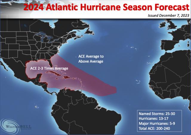
Before jumping into Houston’s forecast, I want to say a few words about a seasonal hurricane forecast that has been generating a lot of attention. You may have seen it on a local TV station, social media, or elsewhere, and the gist of it is that the forthcoming Atlantic hurricane season is going to be really busy. The source of this seasonal forecast—which is clearly a case of overhyping things to get attention—is Weather Bell. The not-subtle headline on the forecast is “Hurricane Season from Hell First look.” It was actually issued a month ago (I saw it then and ignored it, FWIW), but it has been gaining traction of late.
The graphic that accompanies the seasonal forecast. (Weather Bell)
Predicting a “season from hell” is quite a statement to make in <checks notes> January. The forecast is not signed, but it reads like it was written by Joe Bastardi, the site’s chief forecaster. I like Joe, and I think he’s a talented forecaster. But he is prone to hyping things up. Case in point is the graphic showing the maximum amount of storms heading into the Gulf of Mexico, Florida, and Southeastern United States. There is just no real way to predict where the favored area of activity will be in a given hurricane season, especially six to nine months in advance. Sure, Joe could be right. But to confidently make such a prediction in January? That’s folly.
The primary basis for this seasonal forecast is that the current El Niño in the Pacific Ocean (which tends to suppress Atlantic hurricane activity) will flip to a La Niña by this summer. For our purposes this really means the months of August, September, and October, when the strongest hurricanes tend to form in the Atlantic. Such a flip is possible, but far from certain. Based on the latest modeling, there’s about a 50 percent chance of La Niña next summer during hurricane season, 40 percent chance of neutral conditions, and 10 percent El Niño. So, hardly a slam dunk.
Here’s what I would take away from all of this. Texas enjoyed an exceedingly quiet hurricane season in 2023, with no real threats to speak of. That is unlikely to be the case again this coming season, when we probably will see more activity in the Gulf of Mexico. But anyone who is selling you on a hurricane season from hell, in January of all months, is probably trying to sell you something else. Caveat emptor. I’d recommend you start paying a little more heed to seasonal forecasts in April and May.
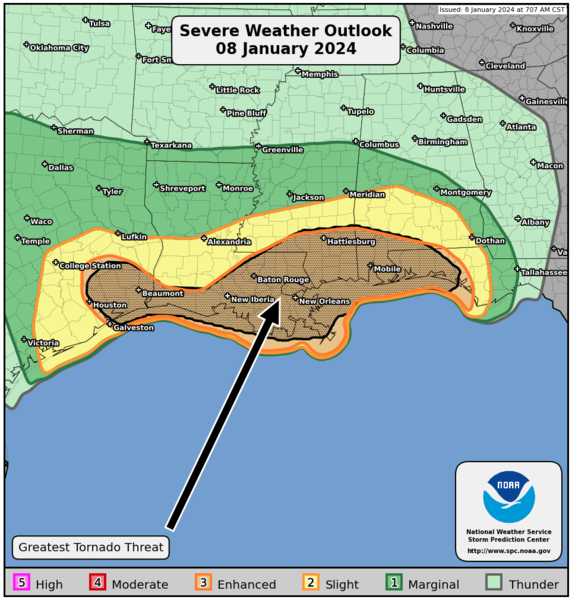
NOAA severe weather outlook for Monday. (NOAA)
Monday
Some light rain is falling across patches of the metro area this morning, and we’ll see some additional showers and a few thunderstorms later this morning and throughout the day. A line of storms will move through this afternoon, likely reaching the downtown area between 4 to 6 pm and then pushing off the coast shortly thereafter. The key question is whether these storms will become severe. We can be confident there will be strong winds, primarily from the west. Expect gusts up to 35 to 40 mph later today. Although the overall chances are low, we also can’t entirely rule out severe thunderstorms with the potential for hail and possibly a tornado. Unfortunately a lot of this mess will be setting up just ahead of the College Football National Championship Game at NRG Stadium this evening, and during the afternoon commute.
Highs today will reach into the low 70s, with a decent level of humidity, before the front pushes through this afternoon. After that we’ll turn breezy and colder, with temperatures dropping to about 40 degrees on Monday night. It’s going to be blustery outside with the strong winds overnight.
Tuesday
Expect cold and sunny weather, with highs in the low 50s. Winds will still be brisk, out of the north, gusting to 30 or even 35 mph. Lows on Tuesday night should drop into the upper 30s in Houston.
Wednesday
Warmer, as winds turn southerly. Expect highs in the upper 60s with mostly sunny skies. Lows on Wednesday night will be much warmer, dropping only into the 50s.
Thursday
Look for highs returning to the low 70s on Thursday, with partly sunny skies. There’s a slight chance of showers.
Friday
A cold front should arrive some time on Thursday night or Friday, chilling us back down again. Look for highs near 60 degrees. Lows on Friday night should drop into the 30s in Houston. Although there remains a fair amount of uncertainty, some parts of the metro area are likely to see at least a light freeze.
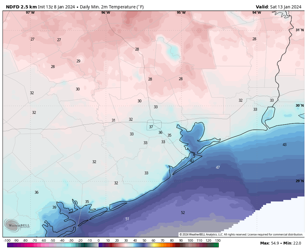
Here’s an early forecast for what temperatures may look like on Saturday morning. (Weather Bell)
Saturday, Sunday, and beyond
We can be confident that Saturday will be mostly sunny and cool, with highs likely in the upper 50s. There remains fairly low confidence for Sunday morning, the start of the Houston marathon. While we can be pretty sure there will be no precipitation, I don’t know whether temperatures will start out in the upper 30s or upper 40s. Daytime highs on Sunday are likely to reach around 60 or 65 degrees, with generally light winds. Fortunately dewpoints look to be reasonably low, so at this point I don’t expect humidity to be too much of a factor. But the models are still bouncing all over the place. Yet another front may arrive on Sunday night. Accordingly much of next week looks chilly, with highs perhaps in the 50s and lows in the 30s. Again, lots of uncertainty so we’ll see how it all plays out.
Earlier this morning, over on our companion site The Eyewall, Matt wrote about a series of winter storms that are going to affect the United States. Part of the post dealt with a topic that a lot of readers have been asking about, the stability of the polar vortex, and whether that means an outbreak of arctic air is likely to reach Texas later this month. The short answer is that yes, the second half of January does look colder. But how cold? That’s a forecast that’s impossible to make as of yet. Here’s Matt with the details.
There has been a lot of speculation on social media about the polar vortex coming later this month. The reasoning is attributed to a sudden stratospheric warming event (SSW) that displaces the polar vortex from the Pole and dumps cold air into the mid-latitudes where most people live. It sounds pretty terrible, unless of course you love cold. So what’s the deal, really?
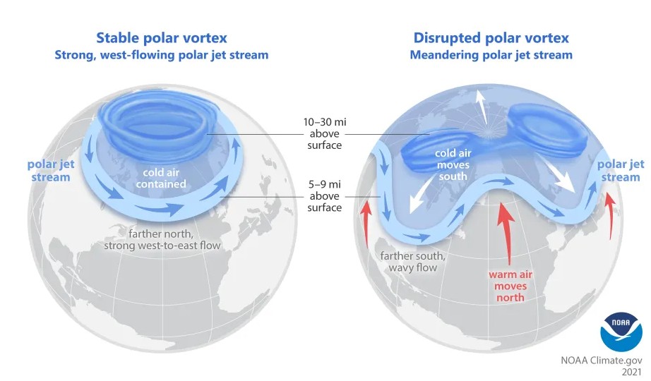
Every winter, the polar vortex strengthens over the North Pole. It basically houses the coldest air in the Northern Hemisphere. It’s never perfectly still, but it’s usually confined to the North Pole. Every so often, the polar vortex can be disrupted, allowing cold to leak out of the polar region and toward the mid-latitudes, where most people live.
An example of a stable polar vortex that is typically seen in winter (left) and a disrupted polar vortex (right), which happens from time to time during winter. (NOAA/UCAR)
The image above lays out, broadly how this happens. For example, this winter has been a mild one for most of the U.S. so far, and it’s not a shock that the polar vortex has been fairly strong.
One of the pathways to displace or split the polar vortex is by what we call a sudden stratospheric warming. What is that, and why does it matter? When we talk about the “polar vortex,” most meteorologists are actually referring to the stratospheric polar vortex. We’re looking about 10 miles and higher up in the atmosphere. That’s the actual polar vortex. When you think of the polar vortex, you’re likely thinking of blobs of intense cold that periodically drop into the U.S. during winter. So, they’re two fundamentally different things. Related, but different.
During some winters, there will be a disruption of the stability in the stratosphere that happens via a sudden warming event, where the strong westerly winds locking the polar vortex over the Pole can weaken or even reverse. When that happens it can release some of that cold from the polar region into the mid-latitudes, impacting the U.S. or Europe or Asia.
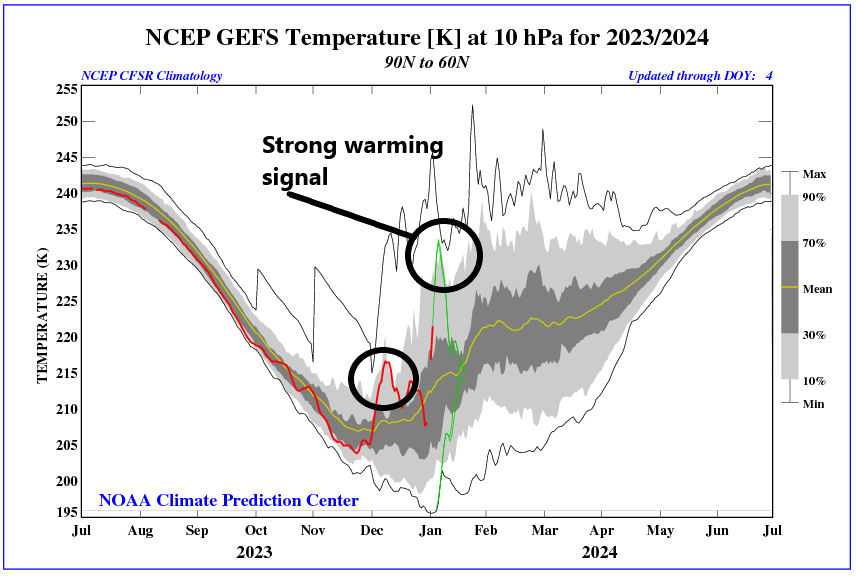
Stratospheric warming is ongoing, which may be enough to qualify as a lower-end sudden stratospheric warming event. (NOAA)
But that’s not a guarantee. No two SSWs are identical, and not every SSW will lead to a “release the hounds” cold air outbreak over the U.S. (or Europe or Asia). There’s a lot that we don’t completely understand about these events and what causes one to produce big cold or another to do little to nothing. But the bottom line here is that this year we are seeing a minor SSW event ongoing. This will do some work on the polar vortex, and it should allow for a relatively wavier jet stream heading into later January. That does not mean a repeat of the February 2021 or December 2022 cold events in Texas, but it could mean some pushes of stronger cold than we’ve seen so far this winter.
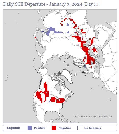
One hurdle right now is that snowfall across North America is running a good bit below normal.
Snowfall across North America is struggling mightily this year. (Rutgers University)
Snow cover is below average in the West, Canada, the Midwest, and Plains. Cold air modifies and moderates as it comes south, and when it travels over less snowy ground, it can moderate faster. This can change in the coming weeks, but will it happen in the Plains? That’s TBD.
The takeaway from all this is that a SSW event does *not* guarantee strong cold air. There are complicating factors involved that can prevent strong cold from materializing. However, an SSW event does tend to weaken the polar vortex and increase the odds that colder air could emerge from the polar regions at times in a few weeks. That does not necessarily mean a repeat of February 2021 (Uri). These types of situations occur several times a decade and most do not produce historic cold air like we saw in that event. But they can produce some of the coldest air of a given winter. So our advice: Sell the hype. But don’t be surprised if the forecast later this month turns a bit colder than we’ve seen so far this winter.
Good morning. Temperatures have dropped into the upper 30s to lower 40s across most of the Houston metro area this morning, and this is the coldest we’re going to get until the middle of next week. We’re still looking at the likelihood of widespread showers on Friday before a mostly sunny and cool winter weekend.
Thursday
After the cool start, temperatures today should reach about 60 degrees under mostly sunny skies. Winds will continue from the east, and we may start to see some gusts this afternoon of 20 or even 25 mph. Clouds will start to build in this evening, but I think rain chances will hold off at least until midnight, and probably more likely until the hours just before sunset on Friday. Look for lows tonight to drop down to around 50 degrees in Houston.
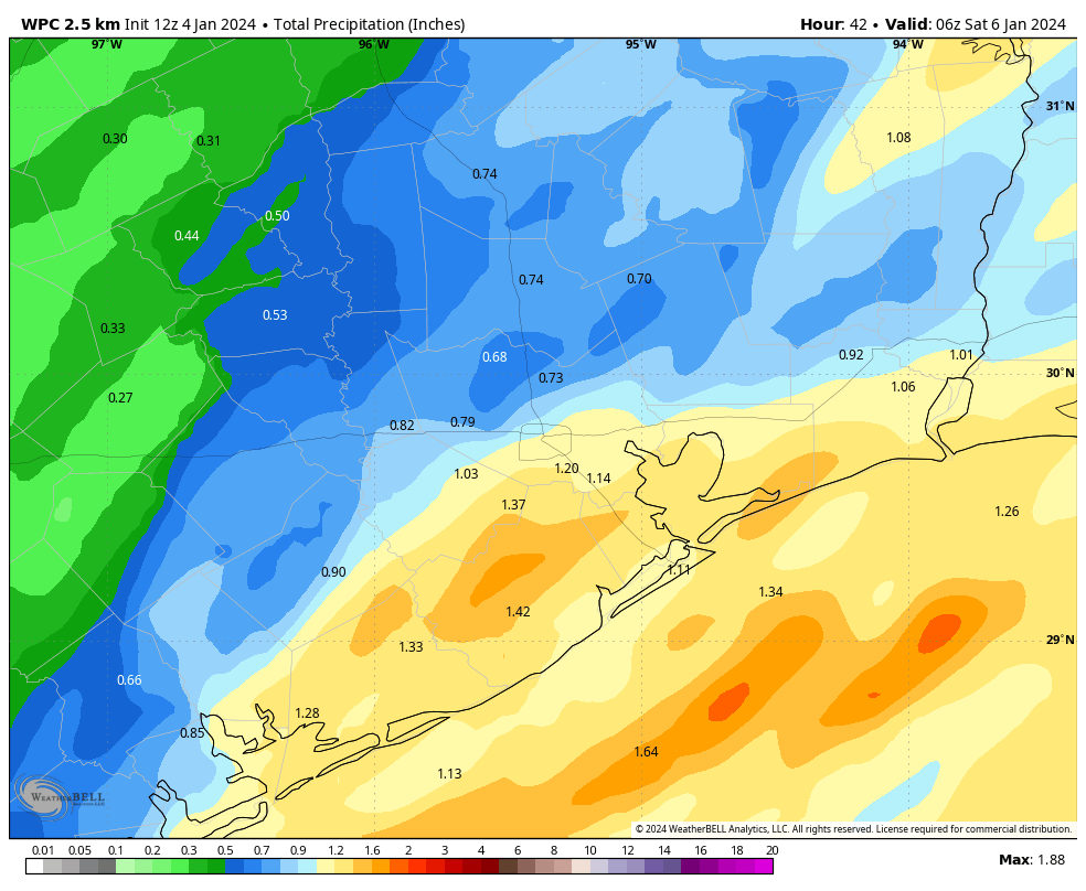
NOAA rain accumulation forecast for now through Friday night. (Weather Bell)
Friday
A low pressure system will bring widespread rain chances on Friday, particularly during the morning hours. There’s no indication in the atmosphere or forecast models for anything extreme, both in terms of rain accumulations or severe thunderstorms. Most of the area probably will pick up between 0.5 and 1.5 inches, with the greater totals more likely south of Interstate 10, closer to the coast. In terms of timing, the showers should generally move in from the west and exit to the east of Houston by around noon, give or take a couple of hours. We should see some partially clearing skies by later Friday afternoon, with highs in the low- to mid-60s.
Saturday and Sunday
The weekend should see partly to mostly sunny skies, with dry air, and daytime highs generally in the low 60s. Friday and Saturday nights should be cool, but by Sunday evening we’ll see a resurgent onshore flow that will start to pump up atmospheric moisture levels and humidity. This will set the stage for another round of showers on Monday.
Monday and Tuesday
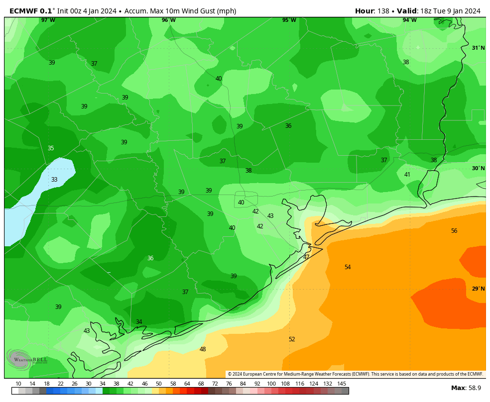
Monday could be a bit dynamic as a strong cold front approaches the area. This will bring showers, and potentially some strong thunderstorms during the daytime. We’ll try to have some better details on this for you in tomorrow’s update. The front will then bring some very strong northerly winds with it, with gusts up to 35 or 40 mph in Houston, and the potential for even stronger winds closer to the coast. These winds are likely to peak on Monday night and Tuesday morning, so that’s something to be aware of if you’re going to be out and about. This may be an issue for any tailgating associated with Monday evening’s College Football Playoff National Championship at NRG Stadium, depending on the timing of the front.
European model forecast for maximum wind gusts on Monday night and Tuesday morning. (Weather Bell)
Tuesday should be sharply colder, with highs only in the 50s to go along with the strong winds. Lows on Tuesday night will probably drop at least into the upper 30s for Houston, with a light freeze possible for areas further inland—we’ll see.
Rest of next week
We’ll likely warm back up by Wednesday or Thursday before another front brings things back down for the weekend. My sense is that startline temperatures for the Houston Marathon on Sunday morning will be in the vicinity of 40 degrees, but there’s still a lot of time to go before that forecast is set in stone.