Earlier this morning, over on our companion site The Eyewall, Matt wrote about a series of winter storms that are going to affect the United States. Part of the post dealt with a topic that a lot of readers have been asking about, the stability of the polar vortex, and whether that means an outbreak of arctic air is likely to reach Texas later this month. The short answer is that yes, the second half of January does look colder. But how cold? That’s a forecast that’s impossible to make as of yet. Here’s Matt with the details.
There has been a lot of speculation on social media about the polar vortex coming later this month. The reasoning is attributed to a sudden stratospheric warming event (SSW) that displaces the polar vortex from the Pole and dumps cold air into the mid-latitudes where most people live. It sounds pretty terrible, unless of course you love cold. So what’s the deal, really?
Every winter, the polar vortex strengthens over the North Pole. It basically houses the coldest air in the Northern Hemisphere. It’s never perfectly still, but it’s usually confined to the North Pole. Every so often, the polar vortex can be disrupted, allowing cold to leak out of the polar region and toward the mid-latitudes, where most people live.
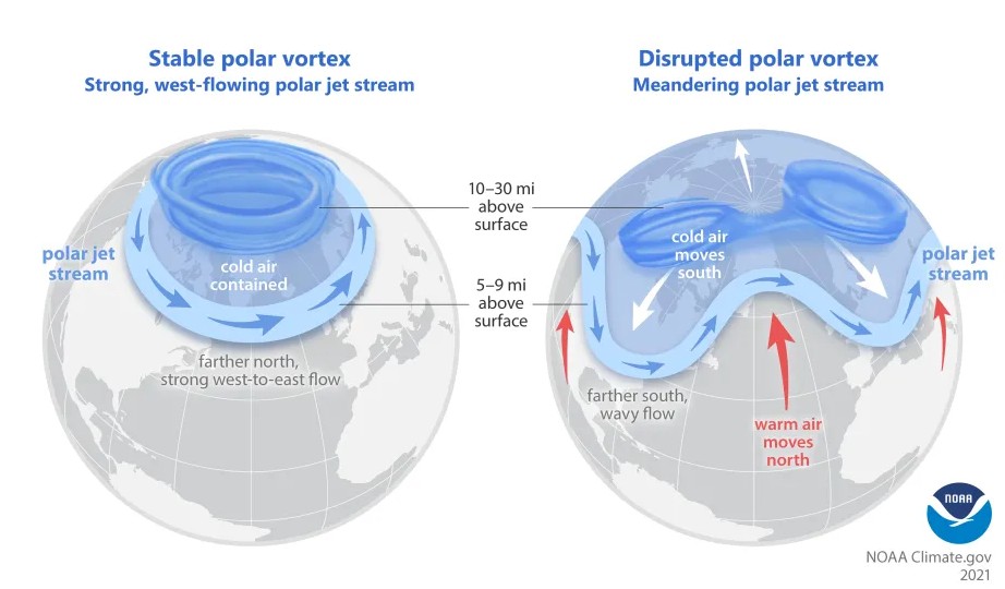
The image above lays out, broadly how this happens. For example, this winter has been a mild one for most of the U.S. so far, and it’s not a shock that the polar vortex has been fairly strong.
One of the pathways to displace or split the polar vortex is by what we call a sudden stratospheric warming. What is that, and why does it matter? When we talk about the “polar vortex,” most meteorologists are actually referring to the stratospheric polar vortex. We’re looking about 10 miles and higher up in the atmosphere. That’s the actual polar vortex. When you think of the polar vortex, you’re likely thinking of blobs of intense cold that periodically drop into the U.S. during winter. So, they’re two fundamentally different things. Related, but different.
During some winters, there will be a disruption of the stability in the stratosphere that happens via a sudden warming event, where the strong westerly winds locking the polar vortex over the Pole can weaken or even reverse. When that happens it can release some of that cold from the polar region into the mid-latitudes, impacting the U.S. or Europe or Asia.
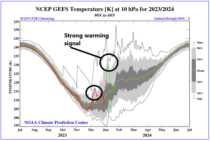
But that’s not a guarantee. No two SSWs are identical, and not every SSW will lead to a “release the hounds” cold air outbreak over the U.S. (or Europe or Asia). There’s a lot that we don’t completely understand about these events and what causes one to produce big cold or another to do little to nothing. But the bottom line here is that this year we are seeing a minor SSW event ongoing. This will do some work on the polar vortex, and it should allow for a relatively wavier jet stream heading into later January. That does not mean a repeat of the February 2021 or December 2022 cold events in Texas, but it could mean some pushes of stronger cold than we’ve seen so far this winter.
One hurdle right now is that snowfall across North America is running a good bit below normal.
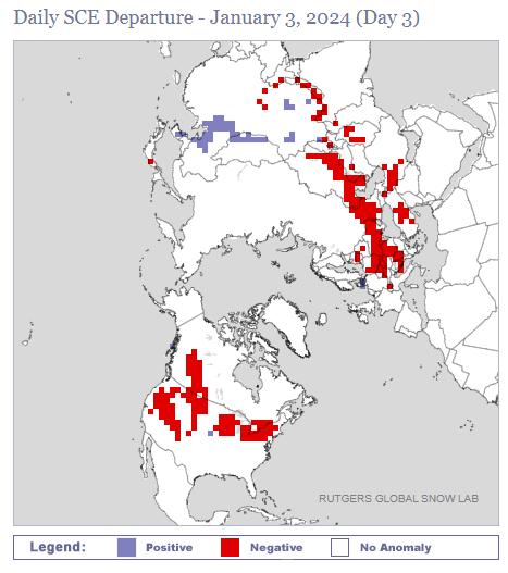
Snow cover is below average in the West, Canada, the Midwest, and Plains. Cold air modifies and moderates as it comes south, and when it travels over less snowy ground, it can moderate faster. This can change in the coming weeks, but will it happen in the Plains? That’s TBD.
The takeaway from all this is that a SSW event does *not* guarantee strong cold air. There are complicating factors involved that can prevent strong cold from materializing. However, an SSW event does tend to weaken the polar vortex and increase the odds that colder air could emerge from the polar regions at times in a few weeks. That does not necessarily mean a repeat of February 2021 (Uri). These types of situations occur several times a decade and most do not produce historic cold air like we saw in that event. But they can produce some of the coldest air of a given winter. So our advice: Sell the hype. But don’t be surprised if the forecast later this month turns a bit colder than we’ve seen so far this winter.


Farmers Almanac expects Jan 24th to be quite the freeze.
Based on…? Crickets buying more blankets? Marbled warblers stocking up firewood?
With respect, the Farmer’s Almanac also said that the coldest periods of winter would include early and late December, which were not that cold.
Thanks for your judicious and calm analysis.
I have seen some fearmongering predictions from other sources.
Kirk Lockwood
Please don’t use names for winter storms.
I’m on your team here, but for Feb 2021, I cannot begin to tell you how “Uri” is used extensively among people. It’s incredible. I blame ERCOT for that since they used it, but alas. Either way, it’s frustrating, but I at least mention it in case people have endorsed it as such.
You guys are great. Keep up the good work!
No one should be at all concerned with the polar vortex, this is an election year and all the hot air that is produced will keep the frigid air far to the north.
That is a great insight…. I actually laughed out loud….LOL
Nobody does this as well as you two!!!!
Thank you for this insightful writing!
Good explanation.
We can still choose to panic if we want too.
Winter Warming Summer Hell!
This is so interesting. I always appreciate what you guys do. Please don’t ever go away.
Agreed ☺️
Polar vortex – well written and informative!
Please no freeze. Especially no rainy and cold weather!